
Record setting heat is expected over the next several days from the Intermountain West through the northern Plains. Furthermore, fire weather concerns increase with dry and breezy conditions. Meanwhile, heavy rainfall and severe thunderstorm threats for the Ohio/Tennessee Valleys, central Appalachians and Southeast today. The threat shifts to central Gulf Coast and across central Texas this week. Read More >
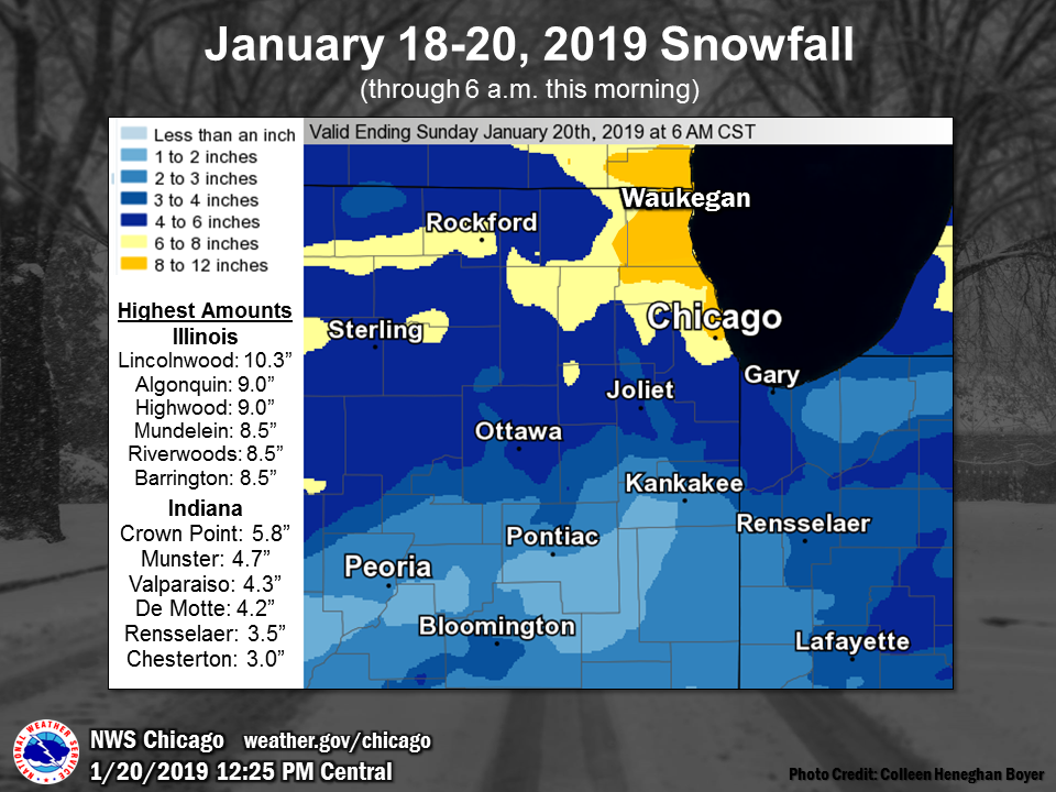
| A widespread snow event occurred on Friday night, Jan 18, through midday on Saturday, Jan 19. Most places received over three inches of snow and along and north of I-88 most places saw 6+" of snow. Winds increased early Saturday resulting in areas of blowing snow and reduced visibility throughout Saturday. After this event was complete, colder air moved into the area generating lake effect snow that mainly impacted northwest Indiana. |
|
|
Fast Facts
Snow/Ice Totals
 |
 |
||
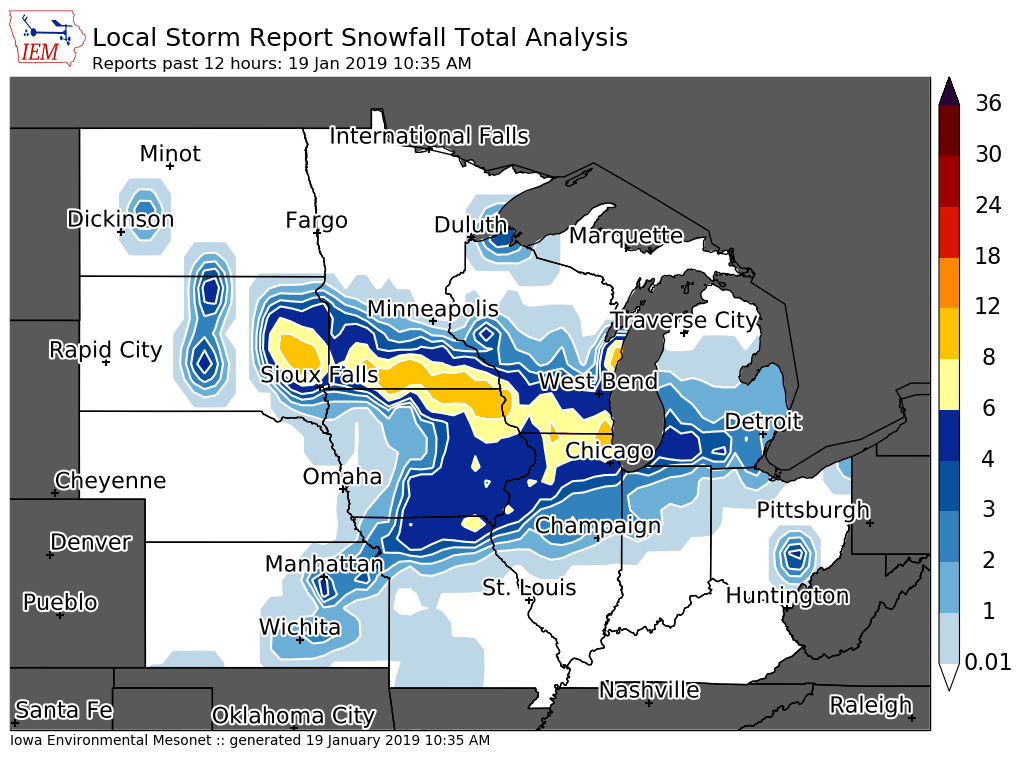
| Regional snowfall map. | Note this map does include some lake effect snow on the night of the 19th in far northeast Illinois. |
Public Information Statement
National Weather Service Chicago/Romeoville IL
1026 AM CST Sun Jan 20 2019


...2-Day Snowfall Roundup...

The following are snow amounts for the previous 2 days
as measured in the morning by NWS Cooperative Observers
and CoCoRaHS observers. Observations are usually
taken at 7 AM.

  2-DAY SNOW TOTALS FOR Sunday (01/20/19)
     as of 10:26 AM CST

ILLINOIS                                 2-Day Snowfall
  Location (County):                         Amt(inches) Reports

  Lincolnwood 2E (Cook)........................10.3     (2)
  Algonquin 1N (McHenry)........................9.0     (2)
  Highwood 1S (Lake)............................9.0     (2)
  Mundelein (Lake)..............................8.5     (2)
  Riverwoods (Lake).............................8.5     (2)
  Harwood Heights (Cook)........................8.5     (2)
  Barrington (Lake).............................8.5     (1)
  Oak Park 2S (Cook)............................8.2     (2)
  Palatine 1NNE (Cook)..........................8.0     (2)
  Buffalo Grove 2N (Lake).......................7.9     (1)
  Genoa (De Kalb)...............................7.9     (2)
  Lake Zurich (Lake)............................7.7     (2)
  Lily Lake 2E (Kane)...........................7.5     (2)
  Wheaton 2NNE (Du Page)........................7.5     (2)
  Waukegan 2N (Lake)............................7.3     (2)
  Oak Park 1NNE (Cook)..........................7.3     (2)
  Lincolnwood 3E (Cook).........................7.2     (1)
  Schaumburg 2E (Cook)..........................7.2     (2)
  Rockford 3NE (Winnebago)......................7.0     (1)
  Gurnee 2NE (Lake).............................7.0     (1)
  Elburn (Kane).................................7.0     (1)
  Hoffman Estates 2SE (Cook)....................7.0     (1)
  Winnetka 1ESE (Cook)..........................7.0     (1)
  Botanic Gardens (Cook)........................7.0     (2)
  Elgin 2W (Kane)...............................6.9     (2)
  Midway Coop (Cook)............................6.8     (2)
  Rockford 1NW (Winnebago)......................6.7     (1)
  Burr Ridge 2SW (Du Page)......................6.7     (2)
  Park Ridge (Cook).............................6.7     (2)
  Palatine 1E (Cook)............................6.7     (2)
  Rockford 6S (Winnebago).......................6.5     (1)
  Rockford 2ENE (Winnebago).....................6.5     (2)
  Lockport 1SE (Will)...........................6.5     (2)
  Cary (McHenry)................................6.5     (1)
  Mundelein 2WNW (Lake).........................6.5     (1)
  Gurnee 2W (Lake)..............................6.5     (1)
  Downers Grove 0.4NNE (Du Page)................6.5     (2)
  Arlington Heights 3SSW (Cook).................6.5     (1)
  Elgin (Kane)..................................6.5     (2)
  Bull Valley 2WNW (McHenry)....................6.4     (2)
  Rockford (Winnebago)..........................6.3     (2)
  Park Ridge 1WNW (Cook)........................6.1     (1)
  De Kalb (De Kalb).............................6.1     (2)
  Crystal Lake 1WSW (McHenry)...................6.1     (2)
  Lake Villa 2WSW (Lake)........................6.0     (1)
  Ashton (Lee)..................................6.0     (1)
  St. Charles (Kane)............................6.0     (1)
  Roselle 1ESE (Du Page)........................6.0     (1)
  Somonauk 2NE (De Kalb)........................6.0     (2)
  Elgin 1S (Kane)...............................5.9     (2)
  Elgin (Kane)..................................5.9     (2)
  Elk Grove Village 1ESE (Cook).................5.8     (2)
  Oak Lawn (Cook)...............................5.8     (2)
  Batavia (Kane)................................5.6     (2)
  North Aurora 2NE (Kane).......................5.5     (2)
  Elk Grove Village 2WSW (Cook).................5.5     (2)
  Batavia 2WNW (Kane)...........................5.2     (2)
  Homewood (Cook)...............................5.1     (2)
  O`hare Airport (Cook).........................5.0     (2)
  Peru 1ENE (La Salle)..........................5.0     (2)
  Sterling 4NE (Lee)............................5.0     (2)
  Aurora (Kane).................................5.0     (2)
  Geneva 4WSW (Kane)............................4.9     (2)
  Batavia 1WSW (Kane)...........................4.9     (2)
  Willow Springs (Cook).........................4.8     (2)
  New Lenox 2SE (Will)..........................4.8     (2)
  Plainfield 2SSE (Will)........................4.8     (2)
  St. Charles 6NW (Kane)........................4.8     (2)
  Plainfield 5SW (Kendall)......................4.7     (2)
  Woodstock 5nw (McHenry).......................4.5     (2)
  Geneva 1SSW (Kane)............................4.5     (2)
  Naperville 1NW (Du Page)......................4.5     (2)
  Elmhurst 2SE (Du Page)........................4.5     (2)
  La Grange Park 1SSW (Cook)....................4.5     (2)
  Palos Park 1SW (Cook).........................4.5     (2)
  Capron (Boone)................................4.5     (2)
  Manhattan (Will)..............................4.4     (2)
  Worth (Cook)..................................4.4     (2)
  Joliet 2n (Will)..............................4.3     (2)
  Carbon Hill 3.1N (Grundy).....................4.3     (2)
  Chicago Ridge (Cook)..........................4.3     (2)
  Coal City 4NNW (Grundy).......................4.3     (2)
  Romeoville (Will).............................4.1     (2)
  Lansing (Cook)................................4.1     (2)
  Peotone (Will)................................4.0     (2)
  La Salle (La Salle)...........................4.0     (2)
  Aurora 4SE (Du Page)..........................4.0     (2)
  Plainfield (Will).............................3.9     (2)
  Crete 3E (Will)...............................3.9     (2)
  Ottawa 2N (La Salle)..........................3.9     (2)
  Paw Paw (Lee).................................3.5     (2)
  Watseka 6.9WNW (Iroquois).....................3.5     (2)
  Mendota (La Salle)............................3.4     (2)
  Steward (Lee).................................3.2     (2)
  Ottawa (La Salle).............................3.0     (2)
  Ottawa 1NW (La Salle).........................3.0     (2)
  Manhattan 1ESE (Will).........................2.8     (2)
  St Anne (Kankakee)............................2.8     (2)
  Bourbonnais (Kankakee)........................2.6     (2)
  Ashkum 5.6E (Iroquois)........................1.8     (2)
  Herscher 3E (Kankakee)........................1.5     (2)
  Paxton (Ford).................................1.5     (2)


INDIANA                                    2-Day Snowfall
  Location (County):                         Amt(inches) Reports

  Crown Point (Lake)............................5.8     (2)
  Crown Point 2WSW (Lake).......................5.0     (2)
  Munster 2NNW (Lake)...........................4.7     (2)
  Valparaiso 6SSW (Porter)......................4.3     (2)
  De Motte 1NNW (Jasper)........................4.2     (2)
  De Motte 4SW (Jasper).........................4.1     (2)
  De Motte 6S (Jasper)..........................3.5     (2)
  Rensselaer 2SSW (Jasper)......................3.5     (2)
  Rensselaer (Jasper)...........................3.0     (2)
  Chesterton 4E (Porter)........................3.0     (1)
  Lakes Of The Four Seasons 2NNE (Porter).......3.0     (1)
  Valparaiso 2WSW (Porter)......................3.0     (1)
  Lowell (Lake).................................2.9     (1)
  Hebron 4NE (Porter)...........................2.9     (2)
  Valparaiso 1NNW (Porter)......................2.5     (2)
  Gary 5ENE (Lake)..............................2.2     (2)
  Lake Village (Newton).........................2.0     (1)
  Hebron 1NE (Porter)...........................2.0     (1)
  Valparaiso 4SW (Porter).......................2.0     (2)
  De Motte 1SSW (Jasper)........................2.0     (1)
  Valparaiso 2NW (Porter).......................1.5     (1)
  Kentland (Newton).............................1.5     (1)
  Remington (Jasper)............................1.5     (1)
  Morocco (Newton)..............................1.0     (1)
Public Snowfall Reports
PRELIMINARY LOCAL STORM REPORT...SUMMARY
NATIONAL WEATHER SERVICE CHICAGO IL
1024 AM CST SUN JAN 20 2019

..TIME...   ...EVENT...      ...CITY LOCATION...     ...LAT.LON...
..DATE...   ....MAG....      ..COUNTY LOCATION..ST.. ...SOURCE....
            ..REMARKS..

0959 AM     HEAVY SNOW       2 E LINCOLNWOOD         42.01N 87.70W
01/20/2019  M10.3 INCH       COOK               IL   COCORAHS

            CORRECTS PREVIOUS HEAVY SNOW REPORT FROM 2 E
            LINCOLNWOOD. STORM TOTAL.

1000 AM     SNOW             WAUKEGAN                42.36N 87.84W
01/20/2019  M9.1 INCH        LAKE               IL   TRAINED SPOTTER

            CORRECTS PREVIOUS SNOW REPORT FROM WAUKEGAN.
            STORM TOTAL.

1000 AM     SNOW             1 N ALGONQUIN           42.18N 88.29W
01/20/2019  M9.0 INCH        MCHENRY            IL   COCORAHS

            STORM TOTAL.

1000 AM     HEAVY SNOW       1 S HIGHWOOD            42.19N 87.81W
01/20/2019  M9.0 INCH        LAKE               IL   COCORAHS

            CORRECTS PREVIOUS HEAVY SNOW REPORT FROM 1 S
            HIGHWOOD. STORM TOTAL.

1138 AM     HEAVY SNOW       PALATINE                42.11N 88.04W
01/19/2019  M8.5 INCH        COOK               IL   TRAINED SPOTTER

            CORRECTS PREVIOUS HEAVY SNOW REPORT FROM
            PALATINE.

1130 AM     SNOW             2 W EVANSTON            42.04N 87.73W
01/19/2019  M6.5 INCH        COOK               IL   PUBLIC


1118 AM     SNOW             1 NW OAK FOREST         41.61N 87.76W
01/19/2019  E6.5 INCH        COOK               IL   PUBLIC

            CORRECTS PREVIOUS SNOW REPORT FROM 1 NW OAK
            FOREST.

1000 AM     SNOW             1 SE LOCKPORT           41.58N 88.04W
01/20/2019  M6.5 INCH        WILL               IL   COCORAHS

            CORRECTS PREVIOUS SNOW REPORT FROM 1 SE
            LOCKPORT. STORM TOTAL.

1000 AM     SNOW             ROCKFORD AIRPORT        42.20N 89.10W
01/20/2019  M6.3 INCH        WINNEBAGO          IL   OFFICIAL NWS OBS

            CORRECTS PREVIOUS SNOW REPORT FROM ROCKFORD
            AIRPORT. STORM TOTAL.

0220 PM     SNOW             DOWNERS GROVE           41.79N 88.01W
01/19/2019  M6.0 INCH        DUPAGE             IL   TRAINED SPOTTER

            CORRECTS PREVIOUS SNOW REPORT FROM DOWNERS
            GROVE.

1206 PM     SNOW             1 S MOUNT PROSPECT      42.05N 87.94W
01/19/2019  E5.5 INCH        COOK               IL   PUBLIC

            CORRECTS PREVIOUS SNOW REPORT FROM 1 S MOUNT
            PROSPECT.

1000 AM     SNOW             3 SW MIDWAY AIRPORT     41.75N 87.79W
01/20/2019  M5.3 INCH        COOK               IL   CO-OP OBSERVER

            CORRECTS PREVIOUS SNOW REPORT FROM 3 SW
            MIDWAY AIRPORT. STORM TOTAL.

1000 AM     SNOW             OHARE AIRPORT           41.98N 87.90W
01/20/2019  M5.0 INCH        COOK               IL   OFFICIAL NWS OBS

            CORRECTS PREVIOUS SNOW REPORT FROM OHARE
            AIRPORT. CORRECTS PREVIOUS SNOW REPORT FROM
            OHARE AIRPORT. STORM TOTAL.

1156 AM     SNOW             MOKENA                  41.53N 87.88W
01/19/2019  E4.8 INCH        WILL               IL   PUBLIC

            CORRECTS PREVIOUS SNOW REPORT FROM MOKENA.

1238 PM     SNOW             1 SE SOUTH HAVEN        41.54N 87.13W
01/19/2019  M4.7 INCH        PORTER             IN   PUBLIC


1000 AM     SNOW             1 ESE CHICAGO           41.88N 87.62W
01/20/2019  M4.7 INCH        COOK               IL   NWS EMPLOYEE

            CORRECTS PREVIOUS SNOW REPORT FROM 1 ESE
            CHICAGO. STORM TOTAL.

1100 AM     SNOW             2 N JOLIET              41.56N 88.08W
01/19/2019  M4.3 INCH        WILL               IL   TRAINED SPOTTER

            CORRECTS PREVIOUS SNOW REPORT FROM 2 N
            JOLIET.

1200 PM     SNOW             ROMEOVILLE              41.65N 88.09W
01/19/2019  M4.1 INCH        WILL               IL   OFFICIAL NWS OBS

            STORM TOTAL SO FAR.

1130 AM     SNOW             MOKENA                  41.53N 87.88W
01/19/2019  M4.1 INCH        WILL               IL   TRAINED SPOTTER

            CORRECTS PREVIOUS SNOW REPORT FROM MOKENA.

0237 PM     SNOW             PEOTONE                 41.33N 87.79W
01/19/2019  M4.0 INCH        WILL               IL   CO-OP OBSERVER

            CORRECTS PREVIOUS SNOW REPORT FROM PEOTONE.
            LIQUID EQUIVALENT 0.27 STORM TOTAL.

1225 PM     SNOW             LANSING                 41.57N 87.54W
01/19/2019  M3.5 INCH        COOK               IL   CO-OP OBSERVER


1027 AM     SNOW             WHITING                 41.68N 87.49W
01/19/2019  M3.5 INCH        LAKE               IN   PUBLIC

            CORRECTS PREVIOUS SNOW REPORT FROM WHITING.

1111 AM     SNOW             MOKENA                  41.53N 87.88W
01/19/2019  M2.5 INCH        WILL               IL   PUBLIC

            CORRECTS PREVIOUS SNOW REPORT FROM MOKENA.

1038 AM     SNOW             VALPARAISO              41.47N 87.06W
01/19/2019  M2.3 INCH        PORTER             IN   PUBLIC

            CORRECTS PREVIOUS SNOW REPORT FROM
            VALPARAISO.

0530 AM     SNOW             3 SW MIDWAY AIRPORT     41.74N 87.78W
01/20/2019  M1.5 INCH        COOK               IL   CO-OP OBSERVER

            CORRECTS PREVIOUS SNOW REPORT FROM 3 SW
            MIDWAY AIRPORT. SNOWFALL SINCE MIDNIGHT.
            0.05 INCHES OF LIQUID EQUIVALENT. TOTAL
            SNOWFALL SINCE THE EVENING OF 1/18 IS 6.8
            INCHES.
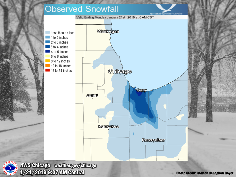
Jan 20-21 Lake Effect Snow
 |
Public Information Statement
National Weather Service Chicago IL
0945 AM CST Mon Jan 21 2019

...Morning Snowfall Roundup...

   The following are snow amounts for the previous 24 hours
   as measured in the morning by NWS Cooperative Observers
   and CoCoRaHS observers.
   Observations are usually taken at 7 AM.

   24-hour Snowfall Amounts for Monday(01/21/19)...


Northern Illinois                              Snow
  Location (County):                           fall(inches)

  Lansing (Cook)................................1.3
  Botanic Gardens (Cook)........................0.5
  Park Forest 1SW (Cook)........................0.4
  Riverwoods (Lake).............................0.4
  Mundelein (Lake)..............................0.4
  Palos Park 4WNW (Cook)........................0.3
  Park Ridge (Cook).............................0.3
  Homewood (Cook)...............................0.3
  Burr Ridge 2SW (Du Page)......................0.3
  Crete 3E (Will)...............................0.3
  Bridgeview 1NNW (Cook)........................0.2
  Chicago Ridge (Cook)..........................0.2
  Harwood Heights (Cook)........................0.2
  Palos Park 1SW (Cook).........................0.2
  Elk Grove Village 1ESE (Cook).................0.2
  Oak Park 1NNE (Cook)..........................0.2
  Elk Grove Village 2WSW (Cook).................0.2
  Lincolnwood 2E (Cook).........................0.2
  La Grange Park 1SSW (Cook)....................0.2
  Midway Coop (Cook)............................0.2
  Downers Grove 0.4NNE (Du Page)................0.1
  Manhattan 5ENE (Will).........................0.1
  Manhattan (Will)..............................0.1
  Ohare Airport (Cook)..........................0.1
  Rockford (Winnebago)..........................0.1
  Elgin (Kane)................................TRACE
  Hoffman Estates 5W (Cook)...................TRACE
  Palatine 1E (Cook)..........................TRACE
  Oak Park 2S (Cook)..........................TRACE
  Downers Grove 0.4NNE (Du Page)..............TRACE
  Aurora 4SE (Du Page)........................TRACE
  Plainfield 5SW (Kendall)....................TRACE
  Elgin 1S (Kane).............................TRACE
  Elgin 2W (Kane).............................TRACE
  Buffalo Grove 2N (Lake).....................TRACE
  Waukegan 2N (Lake)..........................TRACE
  Manhattan 1ESE (Will).......................TRACE
  Peotone (Will)..............................TRACE
  New Lenox 2SE (Will)........................TRACE
  Naperville 4SSW (Will)......................TRACE
  New Lenox 3E (Will).........................TRACE
  Rockford 3NE (Winnebago)....................TRACE
  Mundelein (Lake)............................TRACE
  Peotone (Will)..............................TRACE
  Park Forest (Cook)..........................TRACE

Northwest Indiana                              Snow
  Location (County):                           fall(inches)

  East Chicago 2SW (Lake).......................6.5
  Gary Airport (Lake)...........................6.0
  Hammond 2NW (Lake)............................5.0
  Gary 5ENE (Lake)..............................3.0
  Crown Point 1N (Lake).........................2.6
  Hebron 4NE (Porter)...........................2.6
  Crown Point (Lake)............................2.5
  De Motte 1NNW (Jasper)........................2.0
  Valparaiso 2WSW (Porter)......................1.0
  Crown Point 2WSW (Lake).......................0.8
  Valparaiso 6SSW (Porter)......................0.5
  Valparaiso 4SW (Porter).......................0.5
  Morocco (Newton)..............................0.5
  De Motte 4SW (Jasper).........................0.3
  St. John (Lake)...............................0.3
  Kentland (Newton)...........................TRACE

$$
Additional
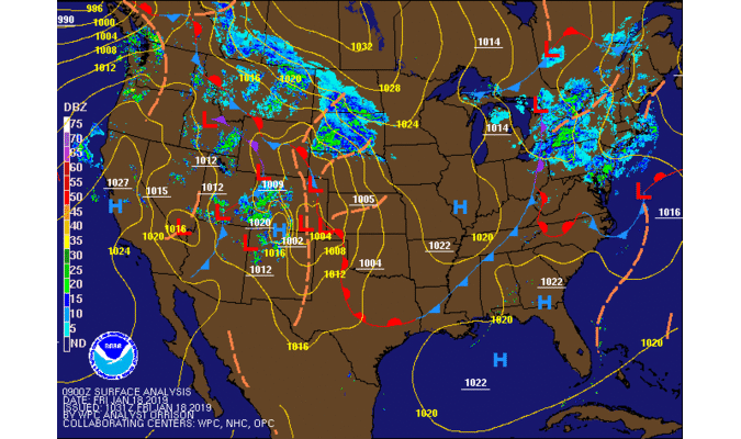 |
| Radar mosaic of the Jan 18-19 event. |
Links
 |
Media use of NWS Web News Stories is encouraged! Additional recaps can be found on the NWS Chicago Science & Past Events Page. |
|

