
Record setting heat is expected over the next several days from the Intermountain West through the northern Plains. Furthermore, fire weather concerns increase with dry and breezy conditions. Meanwhile, heavy rainfall and severe thunderstorm threats for the Ohio/Tennessee Valleys, central Appalachians and Southeast today. The threat shifts to central Gulf Coast and across central Texas this week. Read More >
Records: Chicago O'Hare broke a daily record for warm minimum temperature on June 17. The low was 78° breaking the old record of 77° in 1984.
Saturday, June 16
Maximum/Minimum Temperature and Precipitation Table
National Weather Service Chicago/Romeoville IL
716 AM CDT Sun Jun 17 2018

High temperature yesterday
Low temperature last 12 hours
Precipitation last 24 hours

.BR LOT 0617 C DH01/TAIRZX/DH07/TAIRZP/PPDRZZ

:ID Location                     High   Low    Pcpn
ORD: Chicago-O`Hare           :  92  /  78  /  0.00
CNII2: Chicago-Northerly Isl  :  84  /  71  /
MDW: Chicago-Midway           :  93  /  78  /  0.00
LOTI2: NWS Chicago-Romeoville :  91  /  75  /  0.00
RFD: Rockford Airport         :  90  /  73  /  0.00
DPA: DuPage Airport           :  92  /  74  /  0.00
UGN: Waukegan Airport         :  85  /  72  /  0.00
ARR: Aurora/Sugar Grove       :  93  /  71  /  0.00
PWK: Wheeling/CHI Exec        :  91  /  78  /  0.00
VPZ: Valparaiso IN            :  94  /  74  /  0.00
:
Unofficial Supplemental AWOS Locations
:
DKB: DeKalb                 :  91  /  72  /
JOT: Joliet                 :  93  /  76  /
IKK: Kankakee               :  93  /  74  /
IGQ: Lansing                :  91  /  74  /
C09: Morris                 :  91  /  72  /
VYS: Peru                   :  94  /  77  /
PNT: Pontiac                :  92  /  73  /
RZL: Rensselaer IN          :  90  /   M  /
RPJ: Rochelle               :  90  /  72  /
Sunday, June 17
Public Information Statement...UPDATED
National Weather Service Chicago IL
907 PM CDT Sun Jun 17 2018 /1007 PM EDT Sun Jun 17 2018/
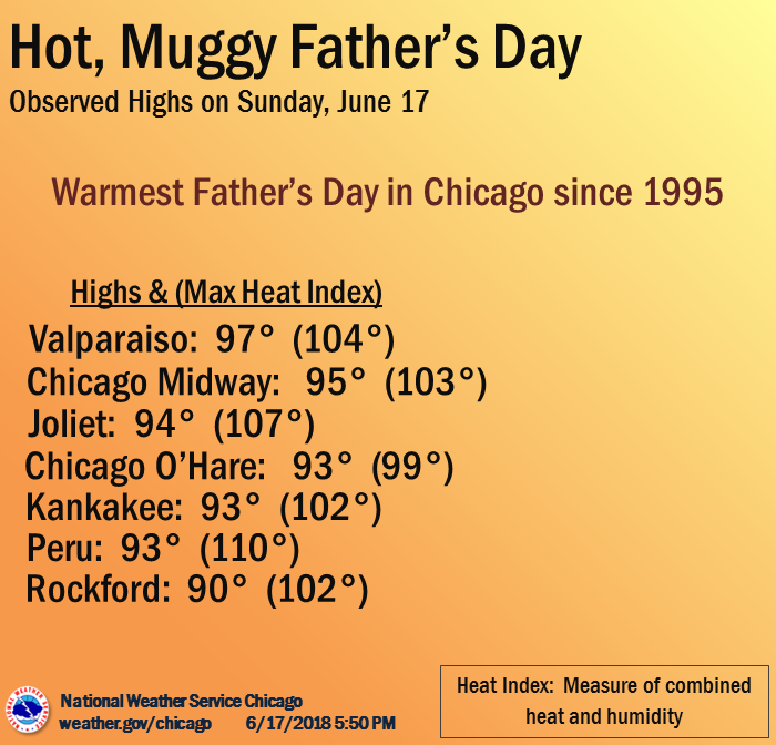
...Highest Temperatures and Heat Index Readings from Sunday
June 17...
Observations are collected from a variety of sources with varying
equipment and exposures. We thank all volunteer weather observers
for their dedication. Not all data listed are considered official.
Location Temp Heat Index
----------------------------------------------------
Valparaiso Airport 97 F 104 F
Chicago Midway Airport 95 F 103 F
Gary Airport 95 F 100 F
Wheeling - Chi Exec Airport 95 F 102 F
Joliet Airport 94 F 107 F
Chicago (O`Hare Airport) 93 F 99 F
Downtown Chicago 93 F
Kankakee Airport 93 F 102 F
Lansing Airport 93 F 105 F
Peru Airport 93 F 110 F
Sugar Grove - Aurora Airport 93 F 102 F
Waukegan Airport 93 F 102 F
West Chicago - DuPage Airport 93 F 103 F
Pontiac Airport 92 F 105 F
Morris Airport 91 F 102 F
Rockford Airport 91 F 102 F
Romeoville - Lewis Airport 91 F 100 F
Rochelle Airport 88 F 101 F
DeKalb Airport 87 F 100 F
Monday, June 18
Maximum/Minimum Temperature and Precipitation Table
National Weather Service Chicago/Romeoville IL
716 PM CDT Mon Jun 18 2018

High temperature last 18 hours
Low temperature last 18 hours
Precipitation last 24 hours

.BR LOT 0618 C DH19/TAIRZS/TAIRZI/PPDRZZ

:ID Location                    High   Low    Pcpn
ORD: Chicago-O`Hare          :  95  /  74  /  0.05
CNII2: Chicago-Northerly Isl :  93  /  67  /
MDW: Chicago-Midway          :  95  /  79  /  0.00
LOTI2: NWS Chicago-Romeoville:  92  /  76  /  0.00
RFD: Rockford Airport        :  91  /  74  /     T
DPA: DuPage Airport          :  93  /  76  /  0.00
UGN: Waukegan Airport        :  92  /  71  /  1.56
ARR: Aurora/Sugar Grove      :  93  /  76  /  0.00
PWK: Wheeling/CHI Exec       :  95  /  76  /     T
VPZ: Valparaiso IN           :  98  /  79  /  0.00
:
Unofficial Supplemental AWOS Locations
:
DKB: DeKalb                 :  92  /  72  /
JOT: Joliet                 :  94  /  78  /
IKK: Kankakee               :  94  /  76  /
IGQ: Lansing                :  94  /  76  /
C09: Morris                 :  91  /  75  /
VYS: Peru                   :  95  /  77  /
PNT: Pontiac                :  92  /  78  /
RZL: Rensselaer IN          :  88  /  82  /
RPJ: Rochelle               :  90  /  73  /

