Record setting heat is expected over the next several days from the Intermountain West through the northern Plains. Furthermore, fire weather concerns increase with dry and breezy conditions. Meanwhile, heavy rainfall and severe thunderstorm threats for the Ohio/Tennessee Valleys, central Appalachians and Southeast today. The threat shifts to central Gulf Coast and across central Texas this week. Read More >
Overview
|
Summary: |
 Event Summary |
Storm Reports
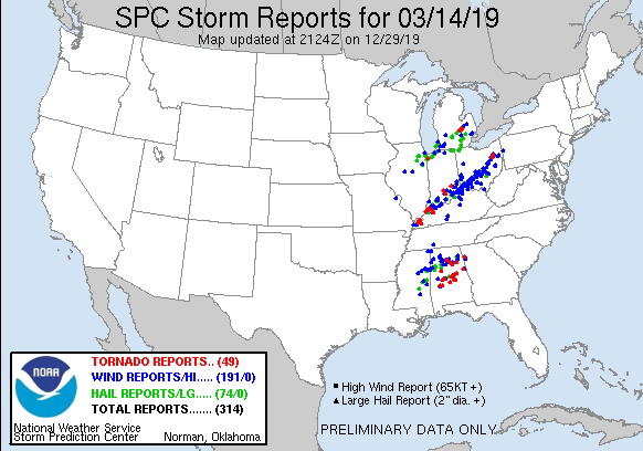 |
| Storm Reports |
PRELIMINARY LOCAL STORM REPORT...SUMMARY
NATIONAL WEATHER SERVICE CHICAGO IL
1125 AM CDT FRI MAR 15 2019
..TIME... ...EVENT... ...CITY LOCATION... ...LAT.LON...
..DATE... ....MAG.... ..COUNTY LOCATION..ST.. ...SOURCE....
..REMARKS..
0645 PM NON-TSTM WND GST GARY AIRPORT 41.62N 87.41W
03/14/2019 M58 MPH LAKE IN AWOS
AWOS STATION GYY, GARY AIRPORT.
0313 PM NON-TSTM WND GST 3 ESE VALPARAISO 41.45N 87.01W
03/14/2019 M62 MPH PORTER IN ASOS
ASOS STATION VPZ, VALPARAISO AIRPORT.
0304 PM NON-TSTM WND GST OHARE AIRPORT 41.98N 87.91W
03/14/2019 M60 MPH COOK IL ASOS
ASOS STATION ORD, CHICAGO OHARE.
0228 PM HAIL 5 SE VALPARAISO 41.42N 87.01W
03/14/2019 E0.70 INCH PORTER IN PUBLIC
0221 PM HAIL 4 N KOUTS 41.37N 87.03W
03/14/2019 E1.00 INCH PORTER IN AMATEUR RADIO
ESTIMATED 60 MPH WINDS.
0153 PM HAIL 4 SW LOWELL 41.25N 87.46W
03/14/2019 E1.00 INCH LAKE IN TRAINED SPOTTER
0153 PM HAIL HAMMOND 41.58N 87.50W
03/14/2019 E1.00 INCH LAKE IN PUBLIC
ESTIMATED 60 MPH WINDS TOO.
0152 PM HAIL 1 SSW MUNSTER 41.53N 87.51W
03/14/2019 E0.25 INCH LAKE IN TRAINED SPOTTER
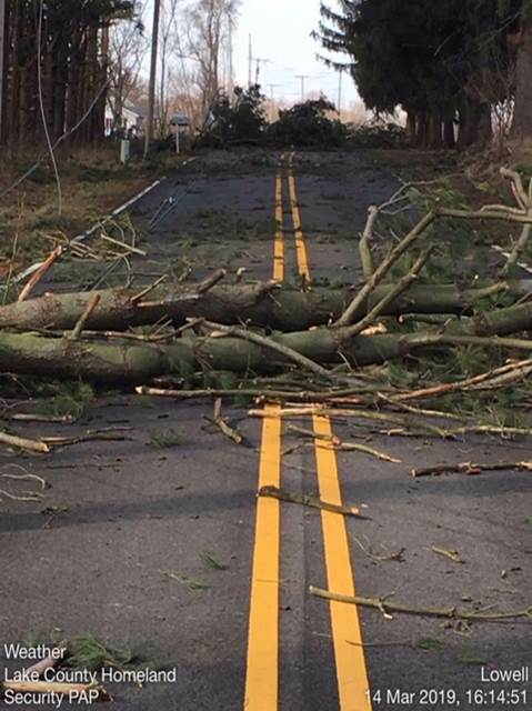
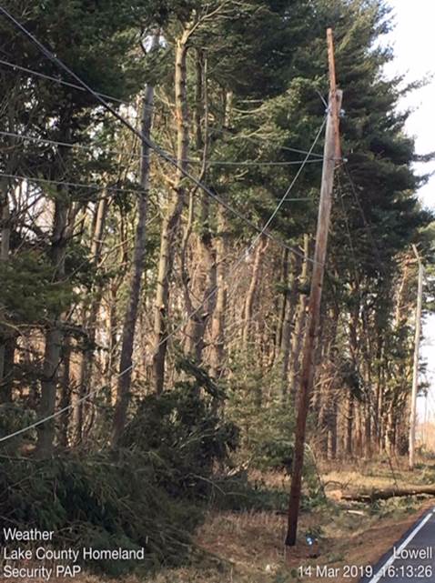
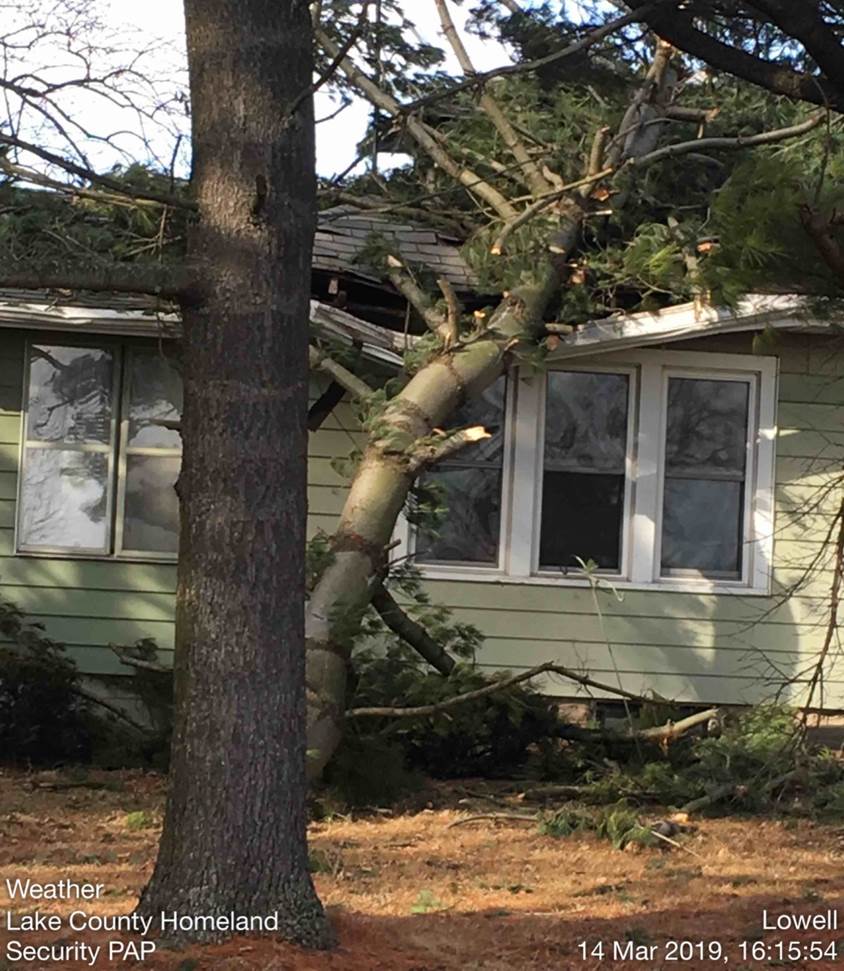
0151 PM TORNADO 2 SSE LOWELL 41.27N 87.41W
03/14/2019 LAKE IN EMERGENCY MNGR
THROUGH PICTURES AND OTHER DATA PROVIDED BY
LAKE COUNTY EMA, AS WELL AS TRAINED STORM
SPOTTERS, A SHORT-LIVED EF-0 TORNADO WAS
CONFIRMED. PATH LENGTH WAS 1.5 MI. DAMAGE
WAS ALMOST ENTIRELY TO TREES, INCLUDING
PORTION OF A LARGE ONE DOWNED ON A HOME.
SOME SHINGLE DAMAGE ON ANOTHER HOME,
MULTIPLE FENCES DAMAGED, AND ONE UTILITY
POLE SNAPPED AND OTHERS DAMAGED.
0149 PM HAIL DYER 41.50N 87.51W
03/14/2019 E1.50 INCH LAKE IN TRAINED SPOTTER
CORRECTS PREVIOUS HAIL REPORT FROM DYER.
0143 PM HAIL 2 SSE SAUK VILLAGE 41.47N 87.55W
03/14/2019 M1.00 INCH WILL IL COCORAHS
0130 PM HAIL MOMENCE 41.16N 87.66W
03/14/2019 E0.25 INCH KANKAKEE IL TRAINED SPOTTER
TRAINED SPOTTER REPORTS PEA SIZED HAIL IN
MOMENCE.
0125 PM HAIL 4 SE PEOTONE 41.30N 87.73W
03/14/2019 E0.25 INCH KANKAKEE IL PUBLIC
0124 PM HAIL 2 ESE LOCKPORT 41.58N 88.03W
03/14/2019 M0.25 INCH WILL IL TRAINED SPOTTER
ALSO 30-40 MPH WINDS.
0115 PM HAIL BOURBONNAIS 41.16N 87.88W
03/14/2019 M0.25 INCH KANKAKEE IL PUBLIC
0115 PM TSTM WND DMG 2 SSW CHEBANSE 40.97N 87.92W
03/14/2019 IROQUOIS IL EMERGENCY MNGR
IROQUOIS COUNTY EMERGENCY MANAGEMENT REPORTS
BARN DESTROYED BY HIGH WINDS. TIME ESTIMATED
BY RADAR.
0110 PM TSTM WND DMG CLIFTON 40.93N 87.94W
03/14/2019 IROQUOIS IL EMERGENCY MNGR
IROQUOIS COUNTY EMERGENCY MANAGEMENT REPORTS
ROOF DAMAGE TO A RESIDENCE IN CLIFTON. TIME
ESTIMATED BY RADAR.
0105 PM HAIL ASHKUM 40.88N 87.96W
03/14/2019 M1.00 INCH IROQUOIS IL TRAINED SPOTTER
1249 PM HAIL OAK BROOK 41.84N 87.95W
03/14/2019 E0.25 INCH DUPAGE IL TRAINED SPOTTER
1248 PM HAIL CLARENDON HILLS 41.80N 87.96W
03/14/2019 E0.25 INCH DUPAGE IL PUBLIC
1233 PM HAIL WILLOWBROOK 41.77N 87.94W
03/14/2019 M0.25 INCH DUPAGE IL PUBLIC
PEA TO HALF INCH HAIL.
1229 PM HAIL GURNEE 42.38N 87.94W
03/14/2019 E0.25 INCH LAKE IL TRAINED SPOTTER
1225 PM HAIL BOLINGBROOK 41.70N 88.07W
03/14/2019 E0.70 INCH WILL IL PUBLIC
1211 PM HAIL 2 W CRYSTAL LAWNS 41.57N 88.20W
03/14/2019 E0.70 INCH WILL IL PUBLIC
1207 PM HAIL 2 SW SHOREWOOD 41.50N 88.22W
03/14/2019 E1.00 INCH WILL IL TRAINED SPOTTER
1207 PM HAIL 1 W SHOREWOOD 41.52N 88.23W
03/14/2019 M1.00 INCH WILL IL NWS EMPLOYEE
1206 PM HAIL MORRIS 41.36N 88.42W
03/14/2019 M0.75 INCH GRUNDY IL PUBLIC
1141 AM HAIL LAKEVIEW 41.95N 87.66W
03/14/2019 E0.70 INCH COOK IL TRAINED SPOTTER
1140 AM HAIL 2 N MAZON 41.27N 88.43W
03/14/2019 E1.00 INCH GRUNDY IL TRAINED SPOTTER
1136 AM HAIL BROOKFIELD 41.82N 87.85W
03/14/2019 E0.25 INCH COOK IL PUBLIC
1132 AM HAIL LYONS 41.81N 87.82W
03/14/2019 E0.25 INCH COOK IL PUBLIC
1129 AM HAIL DARIEN 41.75N 87.97W
03/14/2019 E0.25 INCH DUPAGE IL TRAINED SPOTTER
1121 AM HAIL BOLINGBROOK 41.70N 88.07W
03/14/2019 E0.25 INCH WILL IL TRAINED SPOTTER
1109 AM HAIL DWIGHT 41.09N 88.43W
03/14/2019 E0.25 INCH LIVINGSTON IL LAW ENFORCEMENT
1103 AM HAIL HOMEWOOD 41.56N 87.66W
03/14/2019 M0.25 INCH COOK IL TRAINED SPOTTER
1100 AM TSTM WND DMG 2 NNE PULLMAN 41.73N 87.58W
03/14/2019 COOK IL TRAINED SPOTTER
MULTIPLE TREE BRANCHES DOWN (3-6 INCH
DIAMETER) IN CALUMET HEIGHTS NEIGHBORHOOD OF
CHICAGO.
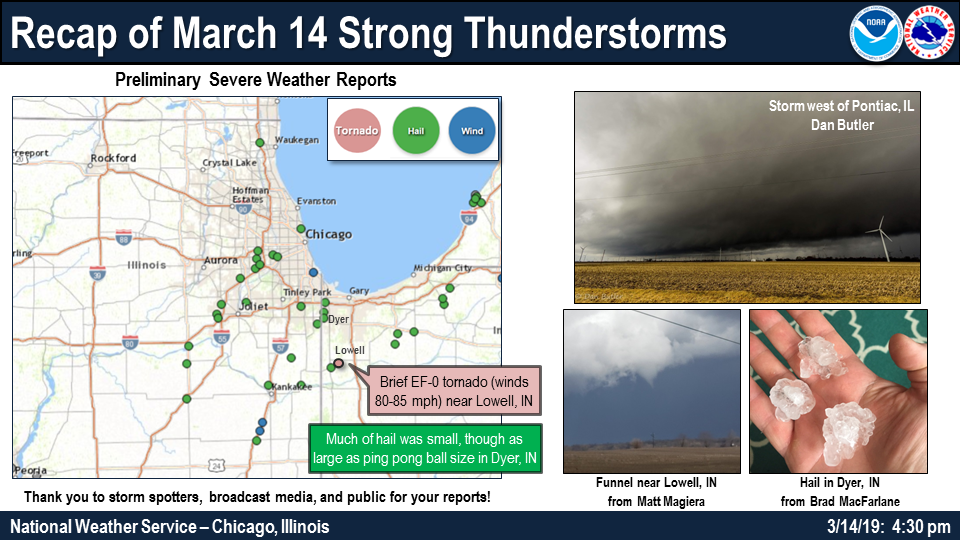
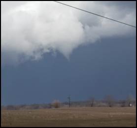
Lowell, Indiana Tornado:
|
Tornado - Lowell, IN
Track Map 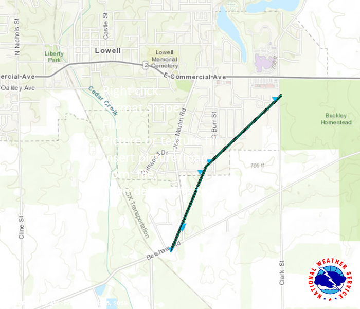 
|
|||||||||||||||||||
The Enhanced Fujita (EF) Scale classifies tornadoes into the following categories:
| EF0 Weak 65-85 mph |
EF1 Moderate 86-110 mph |
EF2 Significant 111-135 mph |
EF3 Severe 136-165 mph |
EF4 Extreme 166-200 mph |
EF5 Catastrophic 200+ mph |
 |
|||||
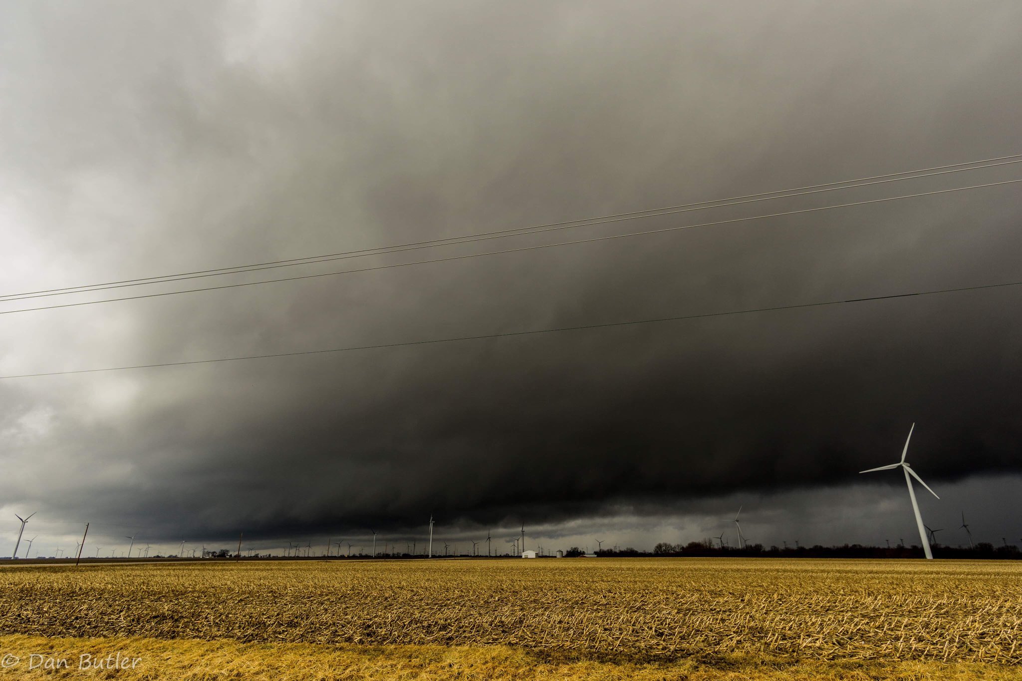
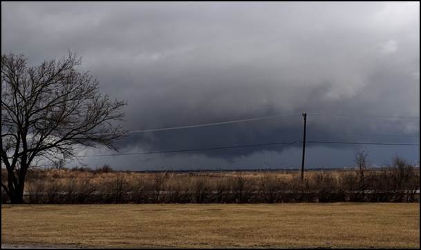
Photos
 |
 |
| Livingston County storm from Dan Butler | Wall Cloud near Minooka, IL by Eric Pershey |
 |
 |
PorterCoStorm-TorWarn.jpg) |
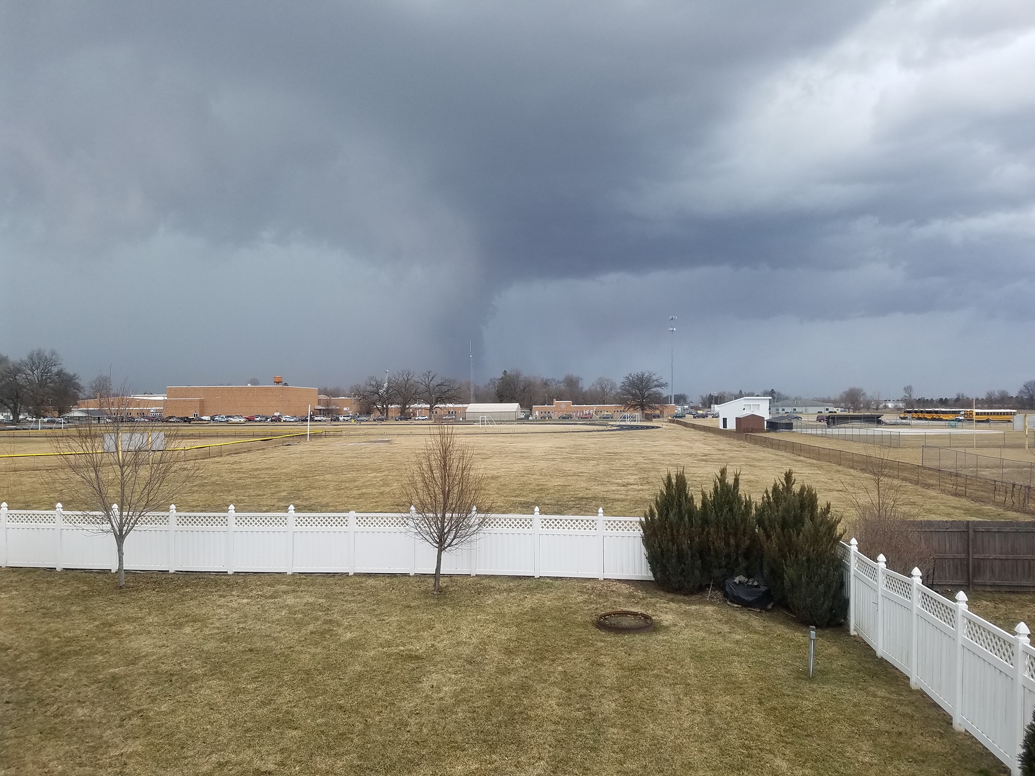 |
| Funnel near Lowell, IN by Matt Magiera | Hail in Dyer, IN by Brad MacFarlane | Porter County by Dan Butler | Lowering and possible wall cloud near the Malden and Kouts area in Porter County, IN by Kelly Barbour. |
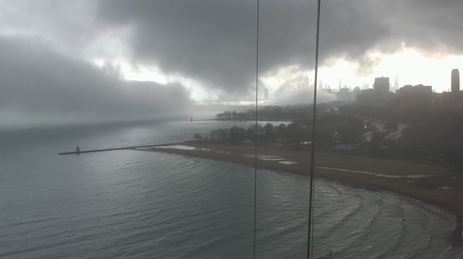 |
| Downtown Chicago early in the afternoon. The low clouds are due to a combination of rain-cooled downdrafts and marine layer fog over the cooler lake. There was not an imminent tornado threat in the city, but one can see how it can easily be mistaken as such with "scary looking clouds" such as this. This is where our trained storm spotter reports are valued so much! |
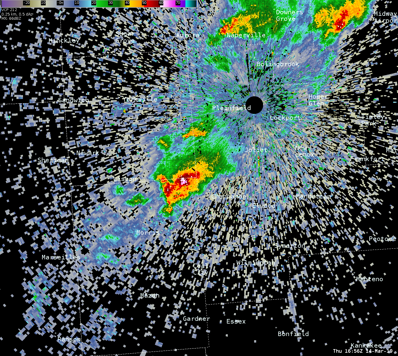
Radar
 |
 |
|
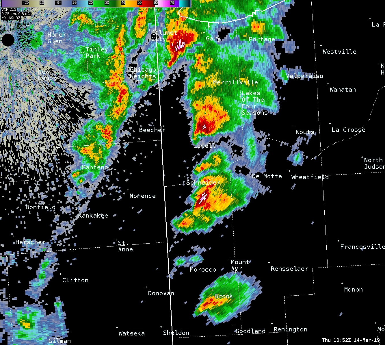
| Small but long-lived supercell that had started in Livingston County and persisted through Cook County. This was a look at it near Minooka. Rotation with this occasionally intensified. | Supercells in northwest Indiana at 1:52 p.m. | Supercells in northwest Indiana at 2:20 p.m. |
Non-Thunderstorm Winds
Public Information Statement
National Weather Service Chicago IL
744 AM CDT Fri Mar 15 2019

...Peak Non-Thunderstorm Wind Gusts from 3/14/19...

The following are peak observed non-thunderstorm wind
gusts from the afternoon and evening of 3/14/19.

Location                     Speed     Time/Date
Valparaiso Airport           62 MPH    0313 PM 03/14
Chicago OHare                60 MPH    0304 PM 03/14
Gary Airport                 58 MPH    0645 PM 03/14
Chicago Crib                 56 MPH    0340 PM 03/14
West Chicago - DuPage Arpt.  55 MPH    0237 PM 03/14
Sugar Grove - Aurora Arpt.   54 MPH    0403 PM 03/14
Joliet Lock-Dam              52 MPH    0500 PM 03/14
Chicago Midway               52 MPH    0336 PM 03/14
Rockford Airport             52 MPH    0133 PM 03/14
Kankakee Airport             51 MPH    0315 PM 03/14
Rensselaer Airport           51 MPH    0315 PM 03/14
Calumet Harbor               50 MPH    0318 PM 03/14
Pontiac Airport              49 MPH    0155 PM 03/14
Rochelle Airport             49 MPH    0235 PM 03/14
Wheeling-Chicago Exec. Arpt. 48 MPH    0504 PM 03/14
DeKalb Airport               48 MPH    0315 PM 03/14
Romeoville - Lewis Airport   48 MPH    0235 PM 03/14
Waukegan Airport             48 MPH    0456 PM 03/14
Peru Airport                 48 MPH    0235 PM 03/14
Morris Airport               47 MPH    0635 PM 03/14
Lansing Airport              46 MPH    0435 PM 03/14
Joliet Airport               45 MPH    0235 PM 03/14

Observations are collected from a variety of sources with varying
equipment and exposures. We thank all volunteer weather observers
for their dedication. Not all data listed are considered official.

$$

Kluber
Meteorology & Additional Info
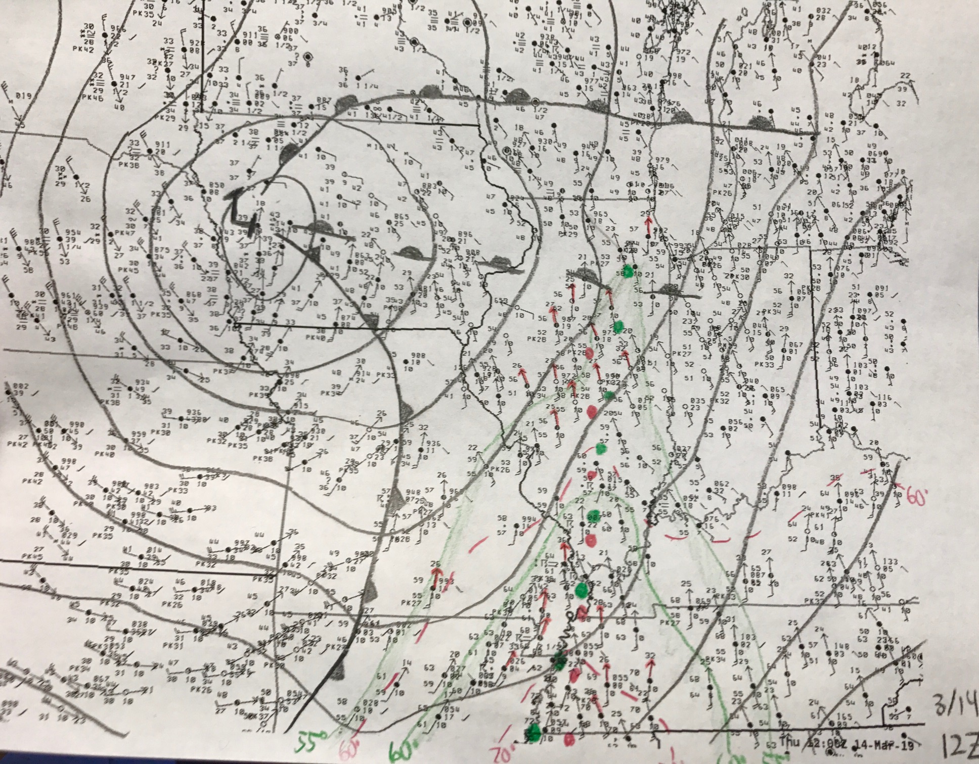 |
| Hand analyzed surface map at 7 am CDT on March 14. Keys are 1.) gusting surface winds helping to drive strong warm and moist (instability) advection, high values of moisture for the time of year, and a deep surface cyclone helping to induce backed surface winds (slightly east of south). These backed winds increase low-level helicity. |
 |
Media use of NWS Web News Stories is encouraged! Please acknowledge the NWS as the source of any news information accessed from this site. Additional recaps can be found on the NWS Chicago Past Events Page |
|