
Record setting heat is expected over the next several days from the Intermountain West through the northern Plains. Furthermore, fire weather concerns increase with dry and breezy conditions. Meanwhile, heavy rainfall and severe thunderstorm threats for the Ohio/Tennessee Valleys, central Appalachians and Southeast today. The threat shifts to central Gulf Coast and across central Texas this week. Read More >
Overview
|
Fast Facts:
|
 Summary |
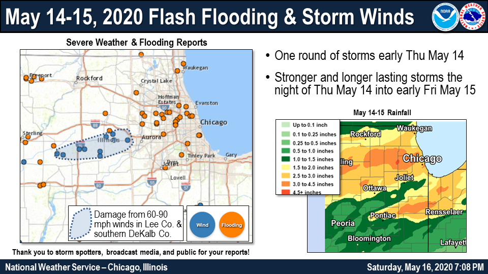
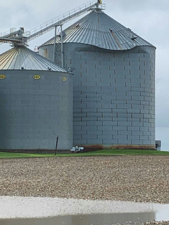
Storm Reports & Damage
 |
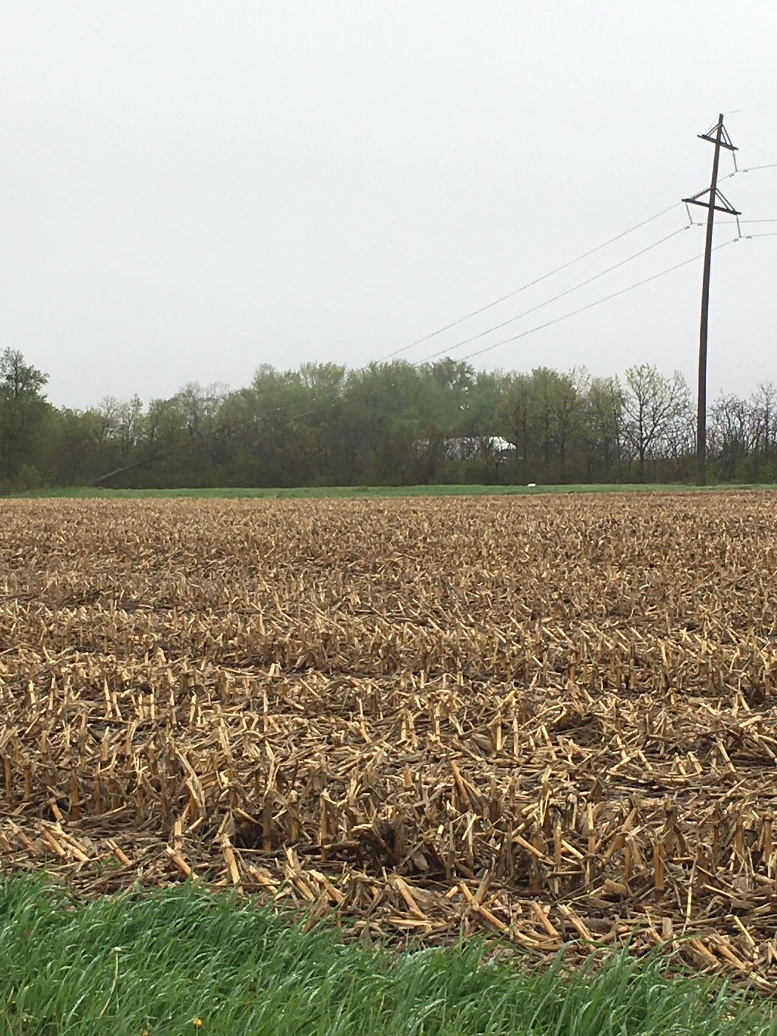 |
| Paw Paw, IL wind damage courtesy of Joel Svendsen. | One of over ten tall wooden utility poles downed along I-39 near Compton, IL. Courtesy of Dixie Eslinger. |
 |
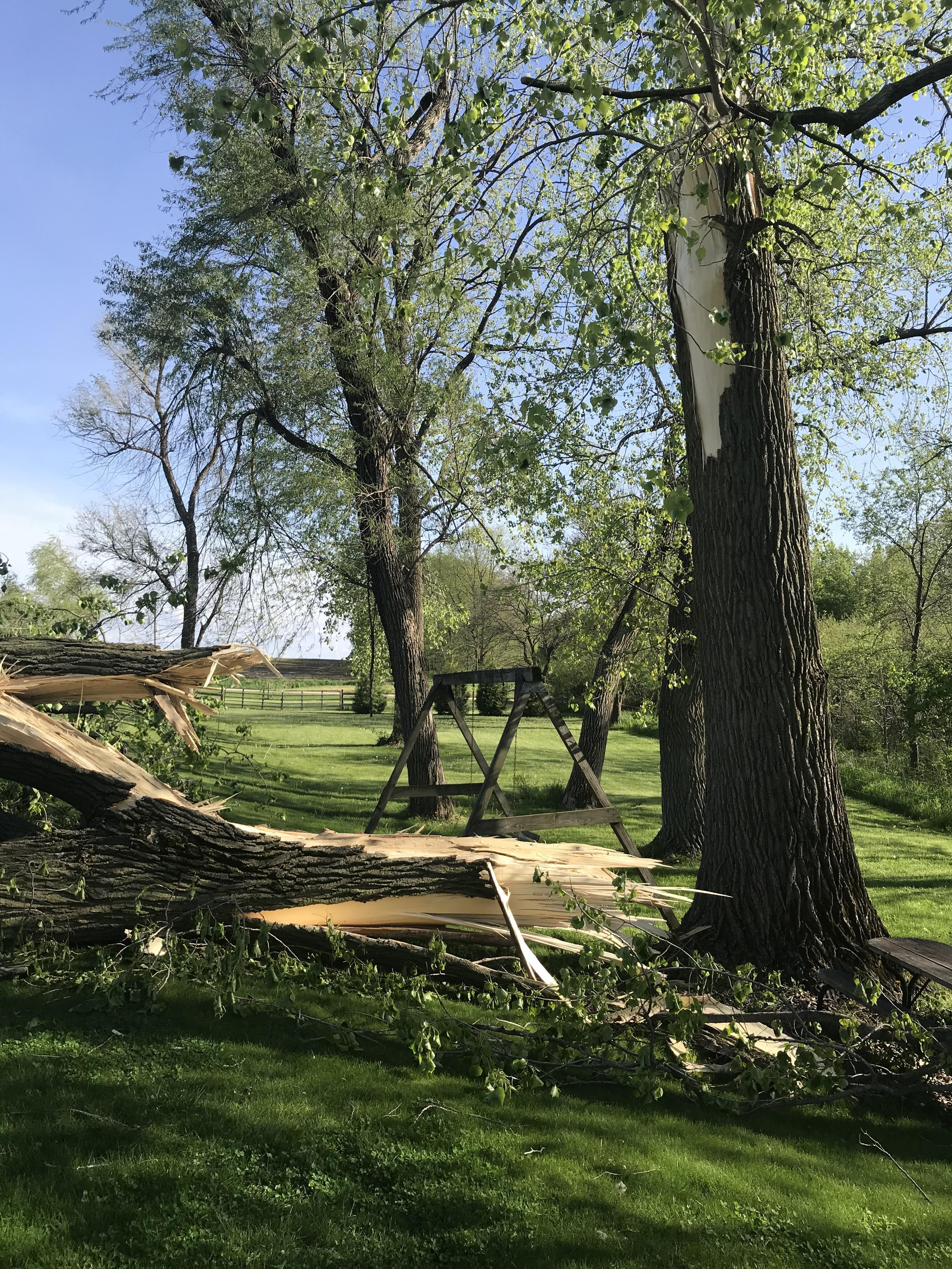 |
| Paw Paw, IL wind damage courtesy of Joel Svendsen. | Tree damage in eastern Lee County between Sublette and Compton, IL. Courtesy of Cora Mathieu. |
PRELIMINARY LOCAL STORM REPORT...SUMMARY
NATIONAL WEATHER SERVICE CHICAGO IL
701 PM CDT SAT MAY 16 2020

..TIME...   ...EVENT...      ...CITY LOCATION...     ...LAT.LON...
..DATE...   ....MAG....      ..COUNTY LOCATION..ST.. ...SOURCE....
            ..REMARKS..

0950 PM     FLASH FLOOD      CORNELL                 41.00N 88.73W
05/14/2020                   LIVINGSTON         IL   PUBLIC

            PUBLIC REPORT VIA SOCIAL MEDIA OF MULTIPLE
            ROADS FLOODED IN NORTHWEST PORTIONS OF
            LIVINGSTON COUNTY. LOCATION APPROXIMATE AND
            ESTIMATED BY RADAR.

0952 PM     FLASH FLOOD      1 N HERSCHER            41.06N 88.09W
05/14/2020                   KANKAKEE           IL   LAW ENFORCEMENT

            ILLINOIS 115 WAS CLOSED DURING THE PEAK OF
            THE HEAVY RAIN DUE TO FLASH FLOODING.

1010 PM     TSTM WND DMG     1 WSW MOMENCE           41.16N 87.69W
05/14/2020                   KANKAKEE           IL   TRAINED SPOTTER

            TREES AND POWER LINES DOWNED JUST WEST OF
            MOMENCE ALONG RIVER ROAD. REPORT RELAYED VIA
            HAM OPERATOR. TIME ESTIMATED VIA RADAR.

1030 PM     FLASH FLOOD      1 NW MOMENCE            41.18N 87.68W
05/14/2020                   KANKAKEE           IL   TRAINED SPOTTER

            ESTIMATED 2-FT OF WATER OVER 4000N ROAD
            NORTHWEST OF MOMENCE. REPORT RELAYED VIA HAM
            RADIO OPERATOR.

1035 PM     FLASH FLOOD      MOMENCE                 41.17N 87.66W
05/14/2020                   KANKAKEE           IL   PUBLIC

            MULTIPLE PUBLIC REPORTS OF FLASH FLOODING IN
            MOMENCE AREA RELAYED VIA MPING.

1045 PM     HEAVY RAIN       3 SW MIDWAY AIRPORT     41.74N 87.78W
05/14/2020  M1.10 INCH       COOK               IL   CO-OP OBSERVER

            RAINFALL AMOUNT FELL IN JUST TEN MINUTES.

1045 PM     HEAVY RAIN       HERSCHER                41.05N 88.10W
05/14/2020  M2.80 INCH       KANKAKEE           IL   BROADCAST MEDIA

            FELL IN 1 HOUR AND 15 MINUTES.

1100 PM     FLASH FLOOD      BRADLEY                 41.15N 87.86W
05/14/2020                   KANKAKEE           IL   LAW ENFORCEMENT

            BRADLEY PD REPORTS VIA SOCIAL MEDIA NUMEROUS
            STREETS AND UNDERPASSES FLOODED IN THE AREA.

1110 PM     TSTM WND DMG     4 W SUBLETTE            41.65N 89.30W
05/14/2020                   LEE                IL   EMERGENCY MNGR

            LEE COUNTY EMERGENCY MANAGEMENT REPORTS TREE
            DAMAGE IN WOODHAVEN AREA NEAR SUBLETTE. TIME
            ESTIMATED BY RADAR.

1118 PM     TSTM WND DMG     SUBLETTE                41.64N 89.23W
05/14/2020                   LEE                IL   PUBLIC

            PART OF ROOF UPLIFTED IN TOWN.

1118 PM     FLASH FLOOD      3.3 E HERSCHER          41.05N 88.03W
05/14/2020                   KANKAKEE           IL   TRAINED SPOTTER

            3.3 INCHES OF RAIN. WATER ALL THE WAY ACROSS
            STATE HIGHWAY 115. WATER ALL THE WAY ACROSS
            MOST ROADS IN THE AREA. HORSE CREEK ABOUT
            90% FULL ON 9000 W RD AND WELL OVER ITS
            BANKS AT 10000W RD AND AT STATE HIGHWAY 15.
            PILOT ROAD FLOODED ALL TEH WAY ACROSS IN
            HERSCHER.

1125 PM     TSTM WND DMG     2 E COMPTON             41.69N 89.04W
05/14/2020                   LEE                IL   PUBLIC

            OVER TEN TALL WOOD UTILITY POLES DOWNED
            ALONG I-39.

1130 PM     FLOOD            1 WNW AMBOY             41.72N 89.34W
05/14/2020                   LEE                IL   EMERGENCY MNGR

            LEE COUNTY EMERGENCY MANAGEMENT REPORTS
            FLOODING OF IL-26 NEAR US-30 AND OF
            RESIDENTIAL STREETS IN AMBOY.

1135 PM     TSTM WND DMG     PAW PAW                 41.69N 88.98W
05/14/2020                   LEE                IL   TRAINED SPOTTER

            ADDS TO PREVIOUS TSTM WND DMG REPORT FROM
            PAW PAW. NUMEROUS TREES DOWNED IN TOWN
            INCLUDING ALONG CHICAGO ROAD, CHAPMAN
            STREET, AND MAPLE STREET. TIME ESTIMATED VIA
            RADAR.

1135 PM     TSTM WND DMG     1 N LELAND              41.63N 88.80W
05/14/2020                   LA SALLE           IL   PUBLIC

            PHOTO SHARED VIA SOCIAL MEDIA OF TREE DAMAGE
            JUST NORTH OF LELAND. TIME ESTIMATED BY
            RADAR.

1150 PM     TSTM WND DMG     4 N LELAND              41.67N 88.80W
05/14/2020                   DE KALB            IL   PUBLIC

            LARGE TREE SNAPPED.

1155 PM     TSTM WND DMG     3 NE WATERMAN           41.80N 88.73W
05/14/2020                   DE KALB            IL   LAW ENFORCEMENT

            TREES AND POWER LINES DOWNED. TIME ESTIMATED
            PER RADAR.

1200 AM     TSTM WND DMG     4 N HINCKLEY            41.82N 88.65W
05/15/2020                   DE KALB            IL   PUBLIC

            CORRECTS PREVIOUS REPORT INCORRECTLY LISTED
            AS FLOOD REPORT. PHOTO SHARED VIA SOCIAL
            MEDIA OF TREE DAMAGE NORTH OF HINCKLEY. TIME
            ESTIMATED VIA RADAR.

1200 AM     FLOOD            2 E HUNTLEY             42.18N 88.38W
05/15/2020                   MCHENRY            IL   PUBLIC

            NUMEROUS PUBLIC REPORTS OF FLOODING IN THE
            HUNTLEY, ALGONQUIN, AND LAKEWOOD AREAS.
            RELAYED VIA MPING.

1206 AM     TSTM WND DMG     HINCKLEY                41.77N 88.64W
05/15/2020                   DE KALB            IL   PUBLIC

            LARGE BRANCHES OF A FEW TREES SNAPPED.

1215 AM     FLASH FLOOD      3 WNW SYCAMORE          42.00N 88.74W
05/15/2020                   DE KALB            IL   PUBLIC

            WATER OVER THE ROAD AND IMPASSIBLE. REPORTED
            AT IL 64 AND 1ST STREET, SYCAMORE, IL.

1220 AM     FLASH FLOOD      5 S CORTLAND            41.85N 88.69W
05/15/2020                   DE KALB            IL   LAW ENFORCEMENT

            WATER REPORTED OVER THE ROAD AND CROP DEBRIS
            FROM THE FIELDS ONTO THE ROAD. REPORTED AT
            PERRY ROAD AND SOMONAUK RD, DEKALB, IL.

1225 AM     TSTM WND GST     2 W SUGAR GROVE         41.77N 88.48W
05/15/2020  M60 MPH          KANE               IL   ASOS

            ASOS STATION KARR SUGAR GROVE - AURORA ARPT.

1230 AM     FLASH FLOOD      ELK GROVE VILLAGE       42.01N 87.99W
05/15/2020                   COOK               IL   TRAINED SPOTTER

            TOWNHOME COMPLEX NEAR THE ALEXIAN BROTHERS
            HOSPITAL NEAR BIESNER ROAD WITH WATER UP TO
            THE DOORWARYS. LAKE NEARBY IS OVERFLOWING.

1240 AM     FLASH FLOOD      1 W ELK GROVE VILLAGE   42.01N 88.02W
05/15/2020                   COOK               IL   PUBLIC

            PUBLIC REPORTS FLOODED RETENTION PONDS
            NEARING RESIDENTIAL STRUCTURES NEAR BEISNER
            ROAD AND GLOUCESTER DRIVE IN ELK GROVE
            VILLAGE. RELAYED VIA SPOTTER NETWORK.

1240 AM     FLASH FLOOD      1 SSE ZION              42.43N 87.83W
05/15/2020                   LAKE               IL   LAW ENFORCEMENT

            MULTIPLE INTERSECTIONS CLOSED DUE TO
            FLOODING IN THE COUNTY, INCLUDING IL 173 AND
            WADSWORTH.

1240 AM     FLASH FLOOD      CAROL STREAM            41.91N 88.14W
05/15/2020                   DUPAGE             IL   PUBLIC

            PUBLIC REPORTS KLEIN CREEK EXCEEDING
            BANKFULL IN CAROL STREAM. RELAYED VIA
            SPOTTER NETWORK.

1250 AM     FLOOD            1 NNW ROSELLE           41.99N 88.08W
05/15/2020                   COOK               IL   PUBLIC

            PUBLIC REPORT OF OVERFLOWING DETENTION POND
            NEAR MARION STREET AND ARTHUR AVENUE IN
            ROSELLE.

1252 AM     FLASH FLOOD      HANOVER PARK            42.00N 88.15W
05/15/2020                   COOK               IL   PUBLIC

            ONE TO TWO FEET OF WATER ON BARRINGTON ROAD.

0100 AM     FLASH FLOOD      1 NE NORWOOD PARK - CHI 42.00N 87.79W
05/15/2020                   COOK               IL   EMERGENCY MNGR

            REPORTED AT DEVON AND MILWAUKEE, CHICAGO,
            IL.

0100 AM     FLOOD            NORTH PARK - CHICAGO    41.98N 87.73W
05/15/2020                   COOK               IL   PUBLIC

            MULTIPLE PUBLIC REPORTS OF FLOODING IN FAR
            NORTHERN SECTIONS OF CHICAGO RELAYED VIA
            MPING.

0100 AM     FLASH FLOOD      CAROL STREAM            41.92N 88.14W
05/15/2020                   DUPAGE             IL   PUBLIC

            PHOTO SHARED VIA SOCIAL MEDIA OF WATER
            NEARING A STRUCTURE NEAR KUHN ROAD AND
            MUNSON DRIVE IN CAROL STREAM.

0115 AM     FLASH FLOOD      1 SSW MEDINAH           41.96N 88.06W
05/15/2020                   DUPAGE             IL   TRAINED SPOTTER

            SIGNIFICANT FLOODING MANY STREETS WATER
            COVERED 2-3 FEET DEEP. SIMILAR REPORTES FROM
            HANOVER, BARTLETTT, CAROL STREAM IN NORTH
            CENTRAL DUPAGE AND COOK COUNTIES.

0130 AM     FLASH FLOOD      NEW CITY - CHICAGO      41.81N 87.65W
05/15/2020                   COOK               IL   EMERGENCY MNGR

            VIADUCT FLOODED. REPORTED AT 47TH AND
            HALSTEAD, CHICAGO, IL.

0130 AM     FLASH FLOOD      ELMHURST                41.90N 87.92W
05/15/2020                   DUPAGE             IL   BROADCAST MEDIA

            ONE TO TWO FEET OF WATER ON THE I-290.

0400 AM     FLASH FLOOD      1 WSW GRAND BOULEVARD - 41.81N 87.64W
05/15/2020                   COOK               IL   BROADCAST MEDIA

            47TH STREET FLOODED AT RAILROAD UNDERPASS
            NEAR SHIELDS AVENUE. WATER RESCUE REPORTED.
            TIME ESTIMATED.

0400 AM     FLASH FLOOD      1 WSW NORTH PARK - CHIC 41.98N 87.75W
05/15/2020                   COOK               IL   BROADCAST MEDIA

            I-94 (EDENS EXPRESSWAY) BRIEFLY CLOSED DUE
            TO FLOODING. MULTIPLE WATER RESCUES OCCURRED
            BETWEEN I-90 AND TOUHY AVENUE.

0500 AM     FLASH FLOOD      SCHILLER PARK           41.97N 87.87W
05/15/2020                   COOK               IL   DEPT OF HIGHWAYS

            IL-DOT REPORTS LAWRENCE AVENUE CLOSED NEAR
            I-294 DUE TO FLOODED UNDERPASS.

0500 AM     FLOOD            1 SSE SOUTH ELGIN       41.98N 88.28W
05/15/2020                   KANE               IL   DEPT OF HIGHWAYS

            IL-DOT REPORTS IL-25 (STEARNS ROAD) CLOSED
            NEAR GILBERT STREET DUE TO FLOODING.

0500 AM     FLOOD            2 NNE LISLE             41.82N 88.06W
05/15/2020                   DUPAGE             IL   DEPT OF HIGHWAYS

            IL-DOT REPORTS IL-53 CLOSED NEAR BUTTERFIELD
            ROAD AND PARK BOULEVARD DUE TO FLOODING FROM
            THE EB DUPAGE RIVER.

0500 AM     FLASH FLOOD      1 ENE ELMHURST          41.91N 87.92W
05/15/2020                   DUPAGE             IL   BROADCAST MEDIA

            NORTH AVENUE CLOSED AT I-290 DUE TO FLOODED
            UNDERPASS. SOME INTERCHANGE RAMPS ALSO
            CLOSED.

0500 AM     FLOOD            1 WSW GOLF              42.06N 87.80W
05/15/2020                   COOK               IL   DEPT OF HIGHWAYS

            IL-DOT REPORTS IL-58 CLOSED AT IL-43 DUE TO
            FLOODING. IL-43 ALSO CLOSED NEAR IL-58 DUE
            TO FLOODED UNDERPASS.

0500 AM     FLOOD            1 N ORLAND PARK         41.64N 87.85W
05/15/2020                   COOK               IL   DEPT OF HIGHWAYS

            IL-DOT REPORTS IL-7 (SOUTHWEST HIGHWAY)
            CLOSED NEAR US-45 DUE TO FLOODING.

0515 AM     FLASH FLOOD      1 NNE INGALLS PARK      41.53N 88.04W
05/15/2020                   WILL               IL   DEPT OF HIGHWAYS

            IL-DOT REPORTS US-30 CLOSED NEAR HIGHLAND
            PARK DRIVE DUE TO FLOODED UNDERPASS.

0720 AM     HEAVY RAIN       HERSCHER                41.06N 88.09W
05/15/2020  M4.10 INCH       KANKAKEE           IL   PUBLIC

            PUBLIC REPORT OF 4.1 IN STORM TOTAL SINCE
            7AM THURSDAY.

0800 AM     HEAVY RAIN       CAROL STREAM            41.91N 88.14W
05/15/2020  M5.67 INCH       DUPAGE             IL   PUBLIC

            36 HOUR STORM TOTAL PRECIPITATION. RELAYED
            BY HAM OPERATOR.

0800 AM     HEAVY RAIN       1 S ST. CHARLES         41.91N 88.31W
05/15/2020  M4.69 INCH       KANE               IL   NWS EMPLOYEE

            STORM TOTAL PRECIPITATION. 24 HOUR TOTAL OF
            3.54 INCHES.

0800 AM     FLASH FLOOD      2 NW FRANKLIN PARK      41.95N 87.90W
05/15/2020                   COOK               IL   DEPT OF HIGHWAYS

            FLOODING OF IRVING PARK ROAD NEAR OHARE
            AIRPORT WITH NUMEROUS CARS FLOODED.

0900 AM     FLOOD            2 NNE DES PLAINES       42.07N 87.88W
05/15/2020                   COOK               IL   DEPT OF HIGHWAYS

            IL-DOT REPORTS CENTRAL ROAD CLOSED BETWEEN
            US-45 AND DEERLOVE ROAD DUE TO FLOODING.

0900 AM     FLOOD            2 NW NORTHLAKE          41.93N 87.92W
05/15/2020                   COOK               IL   DEPT OF HIGHWAYS

            IL-DOT REPORTS GRAND AVENUE NEAR I-294
            CLOSED DUE TO FLOODING.

0900 AM     FLOOD            2 NNW PARK CITY         42.37N 87.90W
05/15/2020                   LAKE               IL   DEPT OF HIGHWAYS

            IL-DOT REPORTS US-41 NEAR IL-132 CLOSED DUE
            TO FLOODING.

0900 AM     HEAVY RAIN       5 S TOWN OF PINES       41.61N 86.96W
05/15/2020  E3.30 INCH       PORTER             IN   TRAINED SPOTTER

            36 HOUR STORM TOTAL PRECIPITATION. 2.03
            INCHES LAST 15 HOURS.

0914 AM     HEAVY RAIN       1 NW SOUTH ELGIN        42.00N 88.31W
05/15/2020  M4.45 INCH       KANE               IL   PUBLIC

            PUBLIC REPORT OF 4.45 INCHES OF RAINFALL
            OVER LAST 2 DAYS.
Rainfall & Flooding
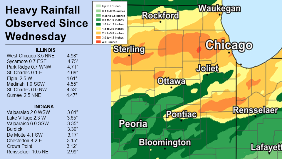 |
.png) |
| Rainfall Totals | Observed official Chicago rainfall (note times/dates). |
 |
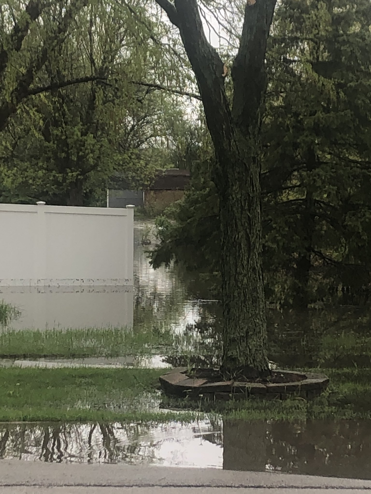 |
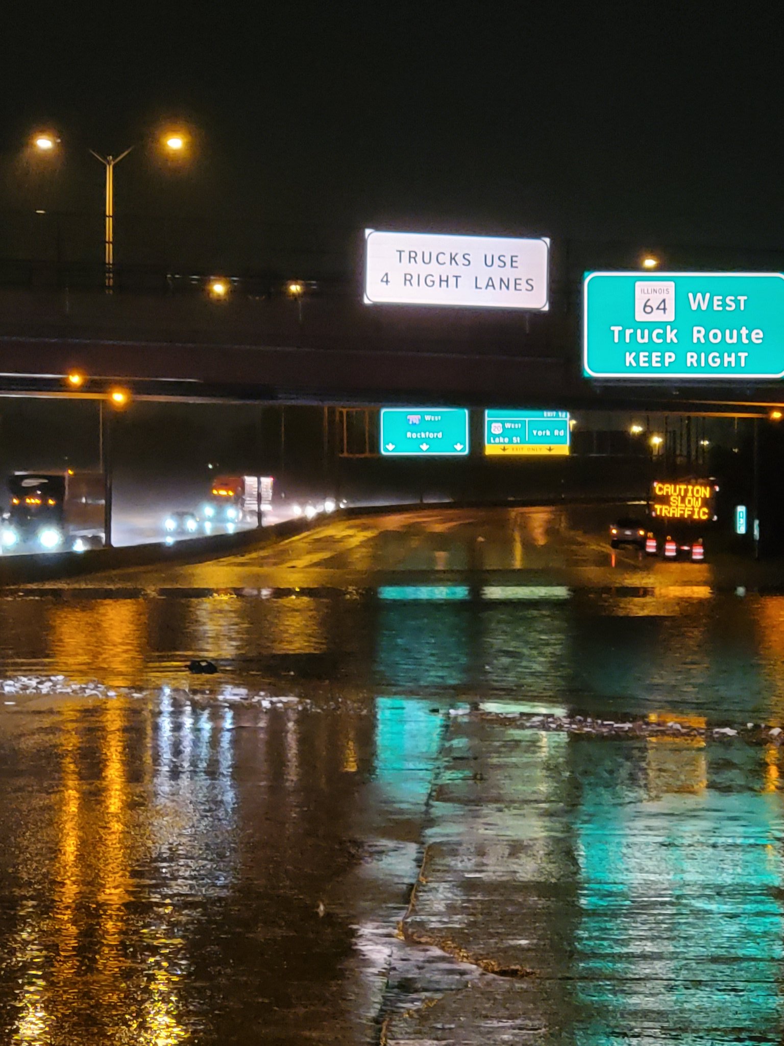
| Flooding photo from media partner, Bill Snyder, near 1:30 a.m. on Friday, May 15. | Roselle, IL flooding from Diego Garcia. |
Public Information Statement
National Weather Service Chicago/Romeoville IL
1214 PM CDT Fri May 15 2020


...2-Day Rainfall Round-up...

The following are rainfall amounts for the previous 2 days
as measured in the morning by NWS Cooperative observers
and CoCoRaHS observers. Observations are usually
taken at 7 AM.

  2-day rain totals for Friday (05/15/20)
     as of 12:14 PM CDT

ILLINOIS                                 2-Day rainfall
  Location (County):                         Amt(inches) reports

  West Chicago 3.5NNE (Du Page)................4.98     (2)
  Park Ridge 1WNW (Cook).......................4.71     (2)
  St. Charles (Kane)...........................4.69     (2)
  Elgin 2W (Kane)..............................4.61     (2)
  Elgin 2WNW (Kane)............................4.57     (2)
  St. Charles 6NW (Kane).......................4.53     (2)
  South Elgin 1NW (Kane).......................4.45     (2)
  De Kalb (De Kalb)............................4.35     (2)
  Kankakee 3.3E (Kankakee).....................4.35     (2)
  Geneva 1SSW (Kane)............................4.3     (2)
  Carol Stream (Du Page).......................4.29     (2)
  Roselle 1ESE (Du Page).......................4.28     (2)
  Batavia 2WNW (Kane)..........................4.28     (2)
  O`hare Airport (Cook)........................4.26     (2)
  Hoffman Estates 5W (Cook)....................4.23     (2)
  Elgin (Kane).................................4.22     (2)
  Cortland (De Kalb)...........................4.22     (2)
  West Chicago (Du Page).......................4.17     (2)
  Elgin 8WSW (Kane)............................4.16     (2)
  Waukegan (Lake)..............................4.14     (2)
  Herscher (Kankakee)..........................4.10     (2)
  Momence (Kankakee)...........................4.07     (2)
  Winnetka 1ESE (Cook).........................4.04     (2)
  Park Ridge (Cook)............................4.02     (2)
  Hoffman Estates 2SE (Cook)....................4.0     (2)
  Kankakee (Kankakee)..........................3.98     (2)
  Batavia 1WNW (Kane)..........................3.98     (2)
  Barrington (Lake)............................3.95     (2)
  Harwood Heights (Cook).......................3.94     (2)
  Elk Grove Village 2WSW (Cook)................3.92     (2)
  De Kalb 1SW (De Kalb)........................3.88     (2)
  Dixon (Lee)..................................3.86     (2)
  Gurnee 2W (Lake).............................3.83     (2)
  Elmhurst 1ESE (Du Page)......................3.81     (2)
  Elgin 1S (Kane)..............................3.81     (2)
  Elgin (Kane).................................3.81     (2)
  Wheaton 2NNE (Du Page)........................3.8     (2)
  Elmhurst (Du Page)...........................3.78     (2)
  Elk Grove Village 1ESE (Cook)................3.73     (2)
  Cary (McHenry)...............................3.72     (2)
  Bourbonnais (Kankakee).......................3.69     (2)
  DeKalb (De Kalb).............................3.67     (2)
  Herscher 3E (Kankakee).......................3.65     (2)
  North Aurora 2NE (Kane)......................3.61     (2)
  Glen Ellyn 1WSW (Du Page).....................3.6     (2)
  Gurnee 2NE (Lake)............................3.58     (1)
  Amboy (Lee)..................................3.56     (2)
  Geneva 4WSW (Kane)...........................3.51     (2)
  Steward (Lee)................................3.43     (2)
  Palatine 1NNE (Cook).........................3.41     (2)
  Gilberts (Kane)..............................3.39     (2)
  Oak Park 1NNE (Cook).........................3.37     (2)
  Ashton (Lee).................................3.34     (2)
  Glen Ellyn 2SSE (Du Page)....................3.33     (2)
  Genoa (De Kalb)...............................3.3     (2)
  Lisle Morton Arb (Du Page)...................3.29     (2)
  Batavia 1WSW (Kane)..........................3.25     (2)
  Schaumburg (Du Page).........................3.25     (2)
  Huntley (McHenry)............................3.24     (2)
  Rogers Park 2SW (Cook).......................3.24     (2)
  Glencoe (Cook)...............................3.23     (2)
  Dixon 3NNW (Lee).............................3.22     (2)
  Elburn (Kane).................................3.2     (2)
  Arlington Heights 1SW (Cook).................3.19     (2)
  Algonquin 1N (McHenry).......................3.18     (2)
  Elmhurst 2SE (Du Page).......................3.13     (2)
  Arlington Heights 1S (Cook)..................3.11     (2)
  Oak Park 1SW (Cook)..........................3.08     (2)
  Dwight (Livingston)..........................3.08     (2)
  Lake Zurich 1N (Lake)........................3.07     (2)
  Oak Park 2S (Cook)...........................3.07     (2)
  Chicago 5NE (Cook)...........................3.06     (2)
  Oregon (Ogle)................................3.02     (2)
  Manteno 2SSE (Kankakee)......................3.02     (1)
  Chicago 6NNE (Cook)..........................3.02     (2)
  Chicago 6ESE (Cook)..........................3.01     (2)
  Waukegan 2N (Lake)...........................2.99     (2)
  Oak Lawn (Cook)..............................2.97     (2)
  Lincolnwood 3E (Cook)........................2.96     (2)
  Villa Park 1NW (Du Page).....................2.95     (1)
  Crystal Lake 1WSW (McHenry)..................2.94     (2)
  Mount Prospect 3NE (Cook)....................2.93     (2)
  Bridgeview 1NNW (Cook).......................2.93     (2)
  Batavia (Kane)...............................2.89     (2)
  Sterling 4NE (Lee)...........................2.86     (2)
  Mundelein (Lake).............................2.86     (2)
  Lincolnwood 2E (Cook)........................2.86     (2)
  Zion (Lake)..................................2.85     (2)
  Mundelein (Lake).............................2.83     (2)
  Palatine 1E (Cook)...........................2.81     (2)
  Buffalo Grove 2N (Lake)......................2.78     (2)
  Winthrop Harbor 1SSW (Lake)..................2.74     (2)
  Chicago Ridge (Cook).........................2.73     (2)
  Midway Coop (Cook)...........................2.72     (2)
  Chebanse (Kankakee)..........................2.71     (2)
  Lisle 1SW (Du Page)..........................2.66     (2)
  Aurora (Kane)................................2.63     (2)
  St Anne (Kankakee)...........................2.62     (2)
  Downers Grove 0.4NNE (Du Page)...............2.61     (2)
  Mendota (La Salle)...........................2.61     (2)
  Naperville 1NW (Du Page)......................2.6     (2)
  Riverwoods (Lake)............................2.59     (2)
  Sugar Grove 1ENE (Kane)......................2.57     (2)
  Aurora 4NE (Du Page).........................2.55     (2)
  Aurora (Kane)................................2.54     (2)
  Mundelein 2WNW (Lake)........................2.53     (2)
  Naperville 2SE (Du Page)......................2.5     (1)
  Sugar Grove 1NE (Kane).......................2.47     (2)
  Oak Lawn 2WNW (Cook).........................2.46     (2)
  Lake Forest 2NNE (Lake)......................2.44     (2)
  Libertyville 2ESE (Lake).....................2.41     (2)
  Peotone (Will)................................2.4     (2)
  Beecher 3SSE (Will)..........................2.38     (2)
  La Grange Park 1SSW (Cook)...................2.38     (2)
  Rochelle (Ogle)..............................2.37     (1)
  Lake Zurich (Lake)...........................2.37     (2)
  Earlville 3S (La Salle)......................2.35     (2)
  Highwood 1S (Lake)...........................2.34     (2)
  Lake Villa 2WSW (Lake).......................2.33     (2)
  Montgomery 1SSE (Kendall)....................2.33     (2)
  Mendota (La Salle)...........................2.29     (2)
  McHenry (Stratton Lock & Dam) (McHenry)......2.27     (2)
  Westmont 1SSW (Du Page)......................2.27     (2)
  Lake Villa 1SSW (Lake).......................2.24     (2)
  Earlville 5NNE (De Kalb).....................2.16     (2)
  Wheeling (Cook)..............................2.14     (2)
  Naperville 2ESE (Du Page)....................2.14     (2)
  Streamwood 1W (Cook).........................2.13     (1)
  Lake Bluff 1W (Lake).........................2.12     (2)
  Lansing (Cook)...............................2.11     (1)
  Beecher 3ENE (Will)...........................2.1     (2)
  Aurora 4SE (Du Page).........................2.09     (2)
  Crystal Lake (McHenry).......................2.04     (2)
  Midway (Cook)................................2.03     (2)
  Romeoville (Will).............................2.0     (2)
  Oswego 5SSE (Kendall)........................1.99     (2)
  Lansing (Cook)...............................1.99     (1)
  Plano (Kendall)..............................1.98     (2)
  Countryside 1ENE (Cook)......................1.97     (2)
  Bolingbrook 3NE (Du Page)....................1.97     (2)
  Aurora 4SE (Du Page).........................1.96     (2)
  Westmont (Du Page)...........................1.93     (2)
  Manhattan 2SE (Will).........................1.93     (2)
  Oak Lawn 2SE (Cook)..........................1.93     (2)
  Palos Park 1SW (Cook)........................1.89     (2)
  Rockford 2ENE (Winnebago)....................1.87     (2)
  Plainfield 3ESE (Will).......................1.86     (2)
  Capron (Boone)...............................1.86     (2)
  Crete 3E (Will)..............................1.82     (2)
  North Utica 6N (La Salle)....................1.77     (2)
  Roscoe 2se (Winnebago).......................1.75     (2)
  Roscoe 2ESE (Winnebago)......................1.75     (2)
  Plainfield 2SSE (Will).......................1.74     (2)
  Naperville 4SSW (Will).......................1.73     (2)
  Watseka 6.9WNW (Iroquois)....................1.73     (2)
  La Salle (La Salle)..........................1.72     (2)
  Burr Ridge 2SW (Du Page).....................1.72     (2)
  Rockford (Winnebago).........................1.68     (2)
  Peru 1ENE (La Salle).........................1.67     (2)
  Somonauk 2NE (De Kalb).......................1.66     (2)
  Bull Valley 2WNW (McHenry)...................1.65     (2)
  Wonder Lake 1WNW (McHenry)...................1.64     (2)
  Harvard (McHenry)............................1.62     (2)
  Paw Paw (Lee)................................1.61     (1)
  Woodstock 5nw (McHenry)......................1.61     (2)
  Elmwood Park 1ESE (Cook).....................1.57     (1)
  Wonder Lake 1NE (McHenry)....................1.56     (2)
  Plainfield 5SW (Kendall).....................1.56     (2)
  Park Forest 1NNE (Cook)......................1.53     (2)
  Flossmoor 1ESE (Cook)........................1.53     (1)
  Pistakee Highlands (McHenry).................1.52     (1)
  Rockford 1NW (Winnebago)......................1.5     (2)
  Marseilles 5WNW (La Salle)...................1.48     (2)
  Woodstock 4SW (McHenry)......................1.46     (2)
  Ottawa 1NW (La Salle)........................1.43     (2)
  Ottawa 2N (La Salle)..........................1.4     (2)
  Romeoville (Will)............................1.39     (2)
  Manhattan 5ENE (Will)........................1.37     (2)
  Coal City 3N (Grundy)........................1.37     (2)
  Pontiac (Livingston).........................1.36     (1)
  Mokena 1W (Will).............................1.36     (2)
  Park Forest (Cook)...........................1.35     (1)
  Ottawa (La Salle)............................1.35     (2)
  Manhattan (Will).............................1.34     (2)
  Lockport 1SE (Will)..........................1.34     (2)
  Gibson 6NE (Ford)............................1.34     (2)
  Midlothian (Cook)............................1.34     (2)
  Flossmoor (Cook).............................1.34     (2)
  New Lenox 3E (Will)..........................1.32     (2)
  Wilmington 3SE (Will)........................1.32     (2)
  Ottawa (La Salle)............................1.32     (1)
  Dwight 4NNW (Grundy).........................1.32     (1)
  Peru (La Salle)...............................1.3     (1)
  Manhattan 1ESE (Will).........................1.3     (2)
  Chatsworth (Livingston).......................1.3     (1)
  Brandon Road Lock & Dam (Will)...............1.29     (1)
  Ashkum 5.6E (Iroquois).......................1.23     (2)
  Pontiac 1SE (Livingston)......................1.2     (1)
  Gibson 2SW (Ford).............................1.2     (1)
  Homewood (Cook)..............................1.19     (2)
  Cropsey 1NE (Livingston).....................1.19     (2)
  Morris 6ESE (Grundy).........................1.16     (1)
  New Lenox 3ENE (Will)........................1.15     (2)
  Morris 5NNW (Grundy).........................1.14     (2)
  Midlothian 1SE (Cook)........................1.12     (1)
  Watseka (Iroquois)............................1.1     (2)
  Minooka (Grundy).............................1.09     (2)
  Coal City (Grundy)...........................1.09     (2)
  Joliet 3WNW (Will)...........................1.08     (2)
  Gibson 3WNW (Ford)...........................1.08     (2)
  Elwood 5NE (Will)............................1.07     (2)
  Naperville 2ESE (Du Page)....................1.06     (1)
  Buckley (Iroquois)...........................1.05     (2)
  Morris 2SSE (Grundy).........................1.05     (2)
  Carbon Hill 3.1N (Grundy)....................1.05     (2)
  Coal City 4NNW (Grundy)......................1.05     (2)
  Joliet 2N (Will).............................1.02     (1)

INDIANA                                    2-Day rainfall
  Location (County):                         Amt(inches) reports

  Valparaiso 2WSW (Porter).....................3.81     (2)
  Lake Village 2W (Newton)......................3.5     (1)
  Valparaiso 6SSW (Porter).....................3.35     (2)
  Burdick (Porter).............................3.30     (2)
  Valparaiso 4SW (Porter)......................3.26     (2)
  De Motte 4SW (Jasper)........................3.17     (2)
  Crown Point 1N (Lake)........................3.12     (2)
  Crown Point (Lake)...........................3.12     (2)
  Rensselaer 10NNE (Jasper)....................2.99     (2)
  Hebron 4NE (Porter)..........................2.94     (2)
  Valparaiso 2WNW (Porter).....................2.94     (2)
  De Motte 1SSW (Jasper).......................2.94     (2)
  De Motte 1NNW (Jasper).......................2.89     (2)
  Valparaiso 2NW (Porter)......................2.89     (2)
  Hebron 1NE (Porter)..........................2.87     (1)
  Valparaiso (Porter)..........................2.86     (2)
  Valparaiso 2N (Porter).......................2.78     (2)
  Lake Village 8SE (Newton).....................2.6     (1)
  Chesterton 1ENE (Porter).....................2.56     (2)
  Wheatfield 3S (Jasper).......................2.48     (2)
  Wheatfield 5W (Jasper).......................2.35     (2)
  De Motte 6S (Jasper).........................2.34     (2)
  Griffith 1N (Lake)...........................2.32     (2)
  Dyer 1WNW (Lake).............................2.19     (1)
  Hobart 1SSW (Lake)...........................2.15     (2)
  Hebron 1NW (Porter)..........................2.14     (1)
  Munster 2NNW (Lake)...........................2.1     (2)
  Wheatfield 4WSW (Jasper).....................2.05     (2)
  Porter 1S (Porter)...........................2.01     (2)
  Rensselaer 5NW (Jasper)......................1.99     (2)
  St. John (Lake)..............................1.98     (1)
  Mount Ayr 2NNE (Newton)......................1.91     (2)
  Fair Oaks 6SW (Newton)........................1.9     (1)
  Portage 3E (Porter)..........................1.89     (2)
  Schererville 2ESE (Lake)......................1.7     (1)
  Morocco (Newton).............................1.68     (2)
  Schererville 1E (Lake).......................1.67     (2)
  Gary 5ENE (Lake).............................1.53     (2)
  Hammond 1SSW (Lake)..........................1.49     (2)
  Kentland (Newton)............................1.36     (1)
  Kentland 2SSE (Newton).......................1.31     (2)
  Rensselaer 8ENE (Jasper).....................1.31     (1)
  Rensselaer (Jasper)..........................1.22     (2)
  Hobart 2E (Lake).............................1.17     (2)
  Rensselaer 2SSW (Jasper).....................1.16     (2)
  Brook 4W (Newton)............................1.05     (2)

$$
Radar
 |
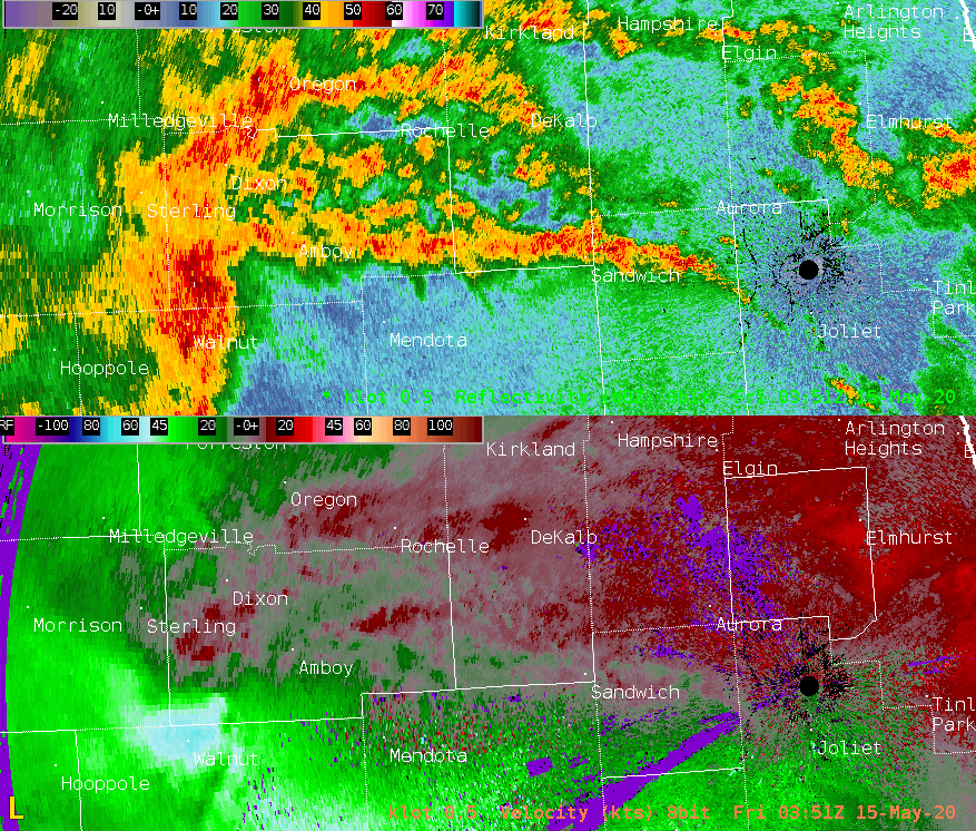 |
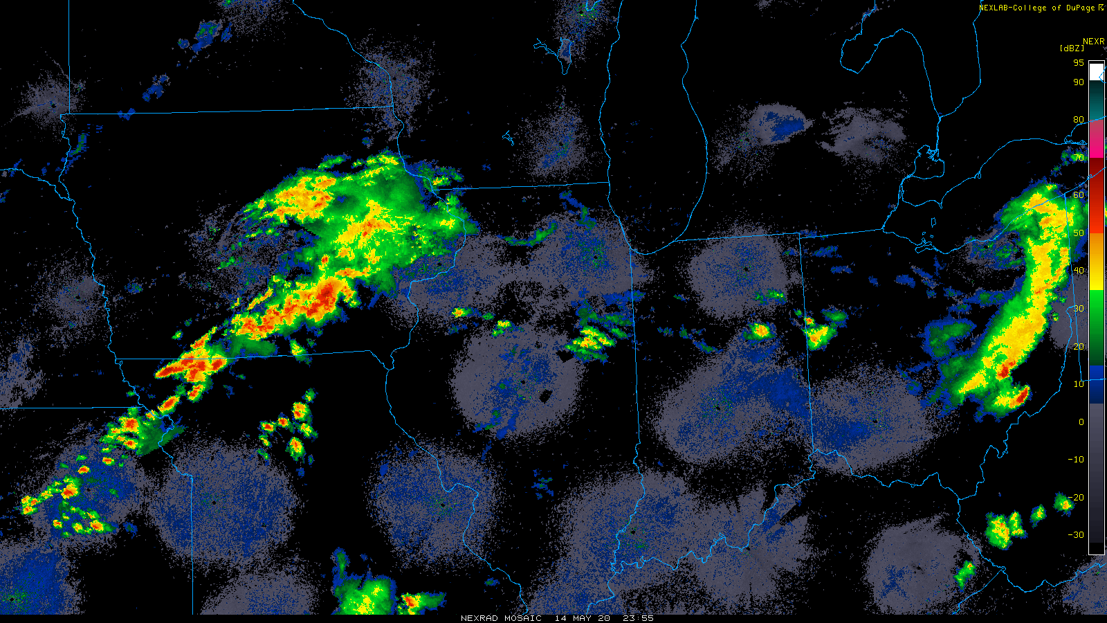
| Regional Radar from 7 p.m. May 14 - 5 a.m. May 15. | NWS Chicago radar loop of the reflectviity (top) and velocity (bottom) that is focused on the organized storm area that produced wind damage from Lee County IL through DeKalb County IL into Kane County, IL. |
Was the NWS Chicago Doppler Radar not Working?
Environment
 |
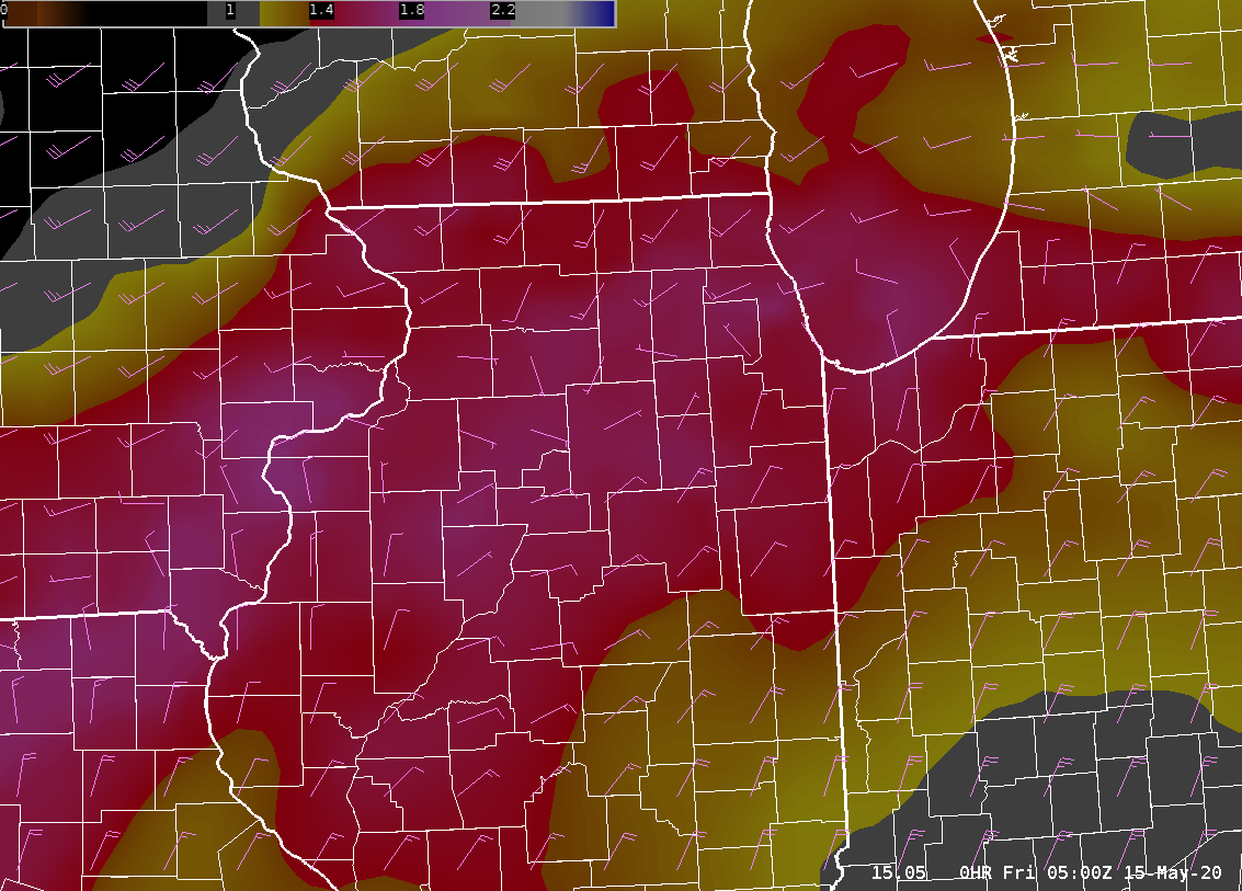 |
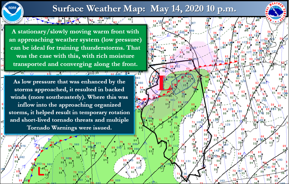
| Surface weather map from Thursday evening, May 14. | Model analysis from midnight on the early morning of Friday, May 15 of precipitable waters (color) up to 1.5+ inches (99th+ percentile for mid-May) and Corfidi Vectors (purple barbs) showing a corridor of minimal organized storm motion near the I-88/I-290 corridor -- a zone where flash flooding from training, slow-moving storms was realized. |
 |
Media use of NWS Web News Stories is encouraged! Please acknowledge the NWS as the source of any news information accessed from this site. Additional recaps can be found on the NWS Chicago Past Events Page |
|

