
Record setting heat is expected over the next several days from the Intermountain West through the northern Plains. Furthermore, fire weather concerns increase with dry and breezy conditions. Meanwhile, heavy rainfall and severe thunderstorm threats for the Ohio/Tennessee Valleys, central Appalachians and Southeast today. The threat shifts to central Gulf Coast and across central Texas this week. Read More >
Overview
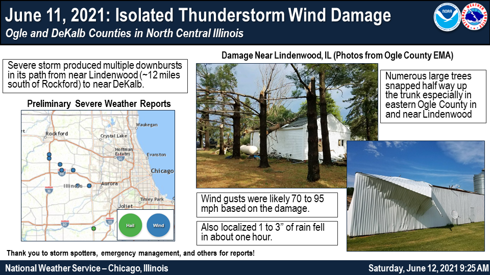
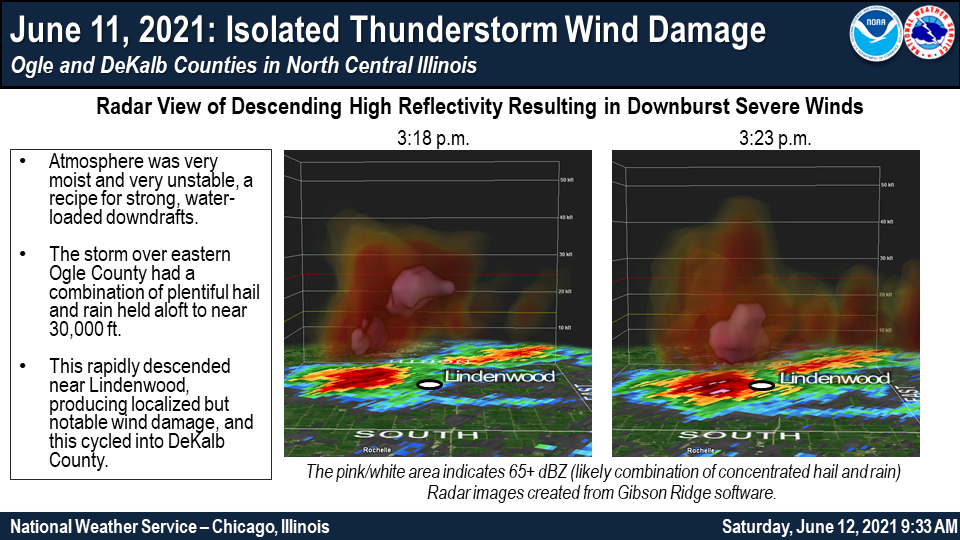
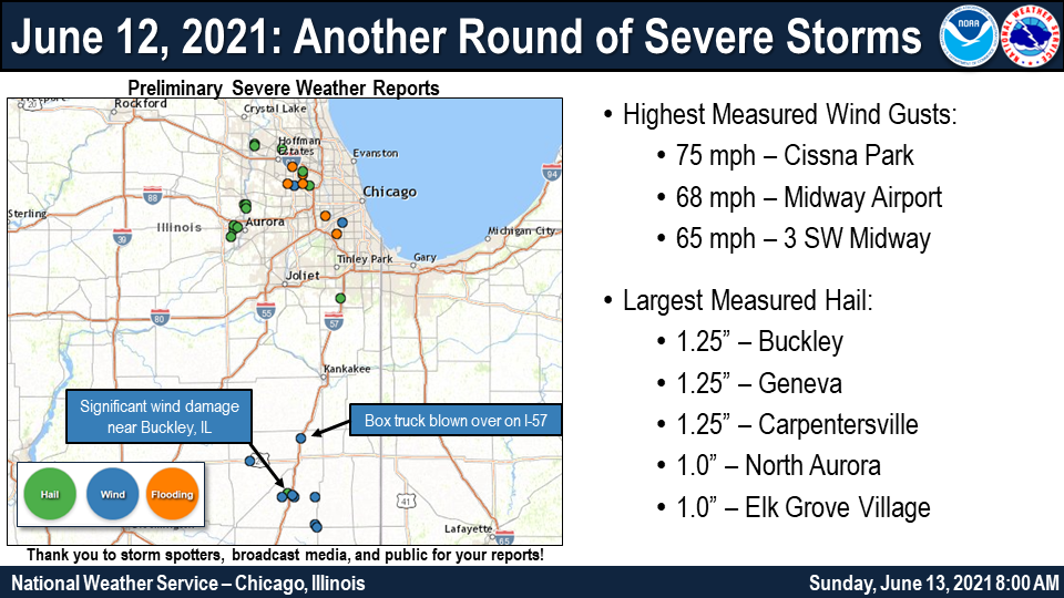
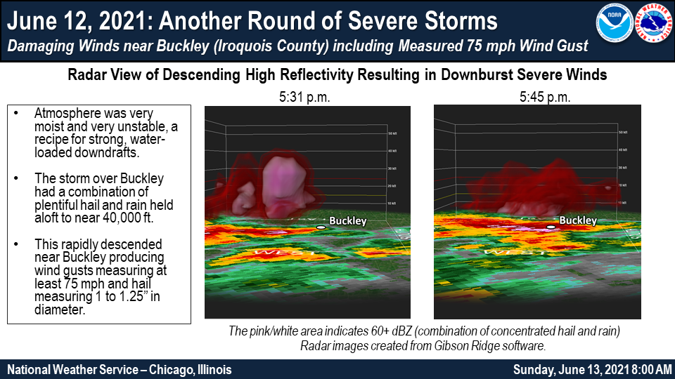
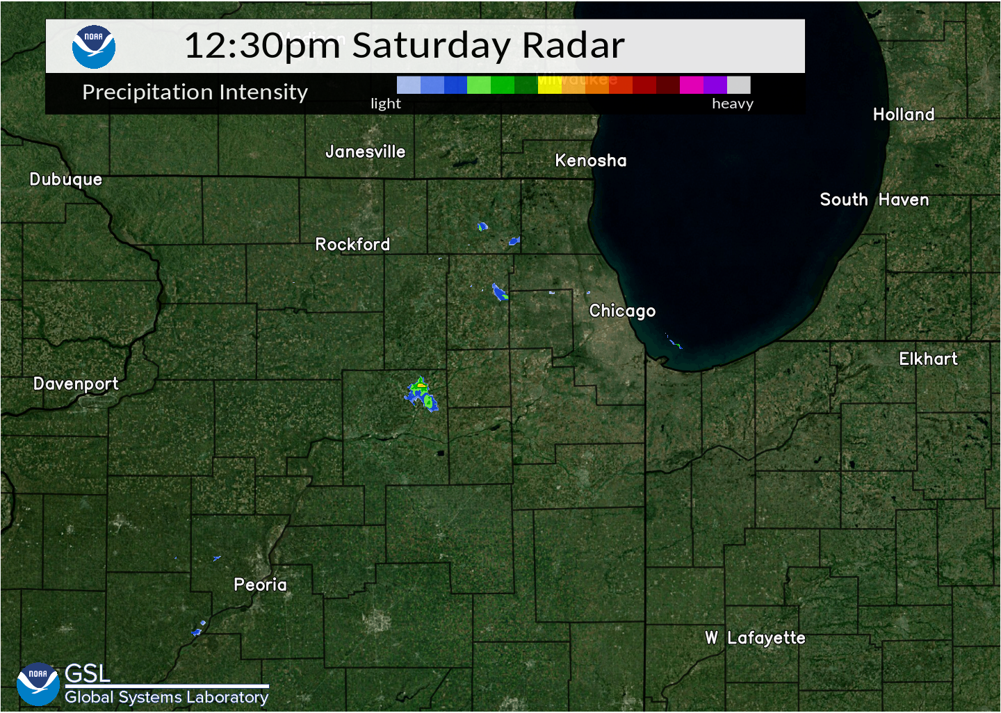
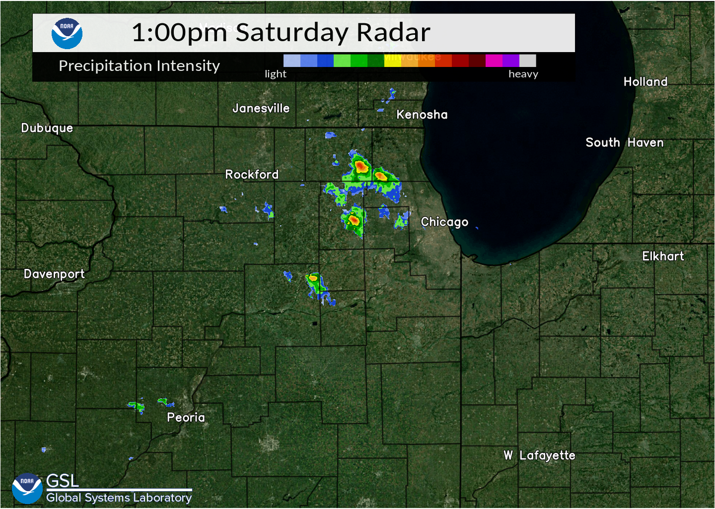
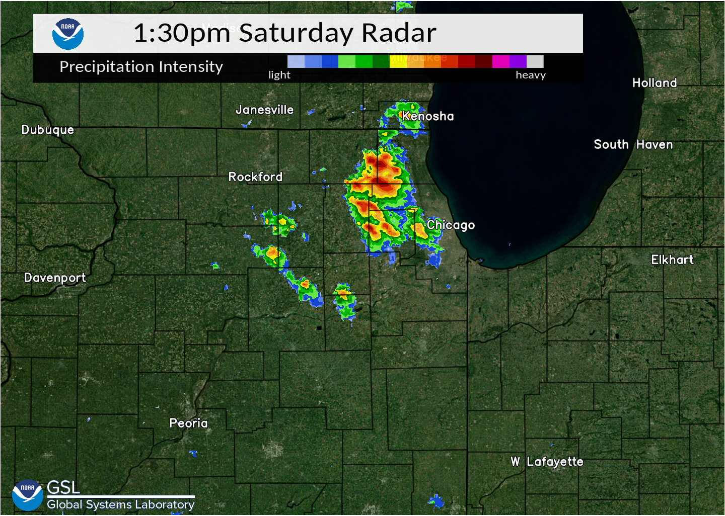
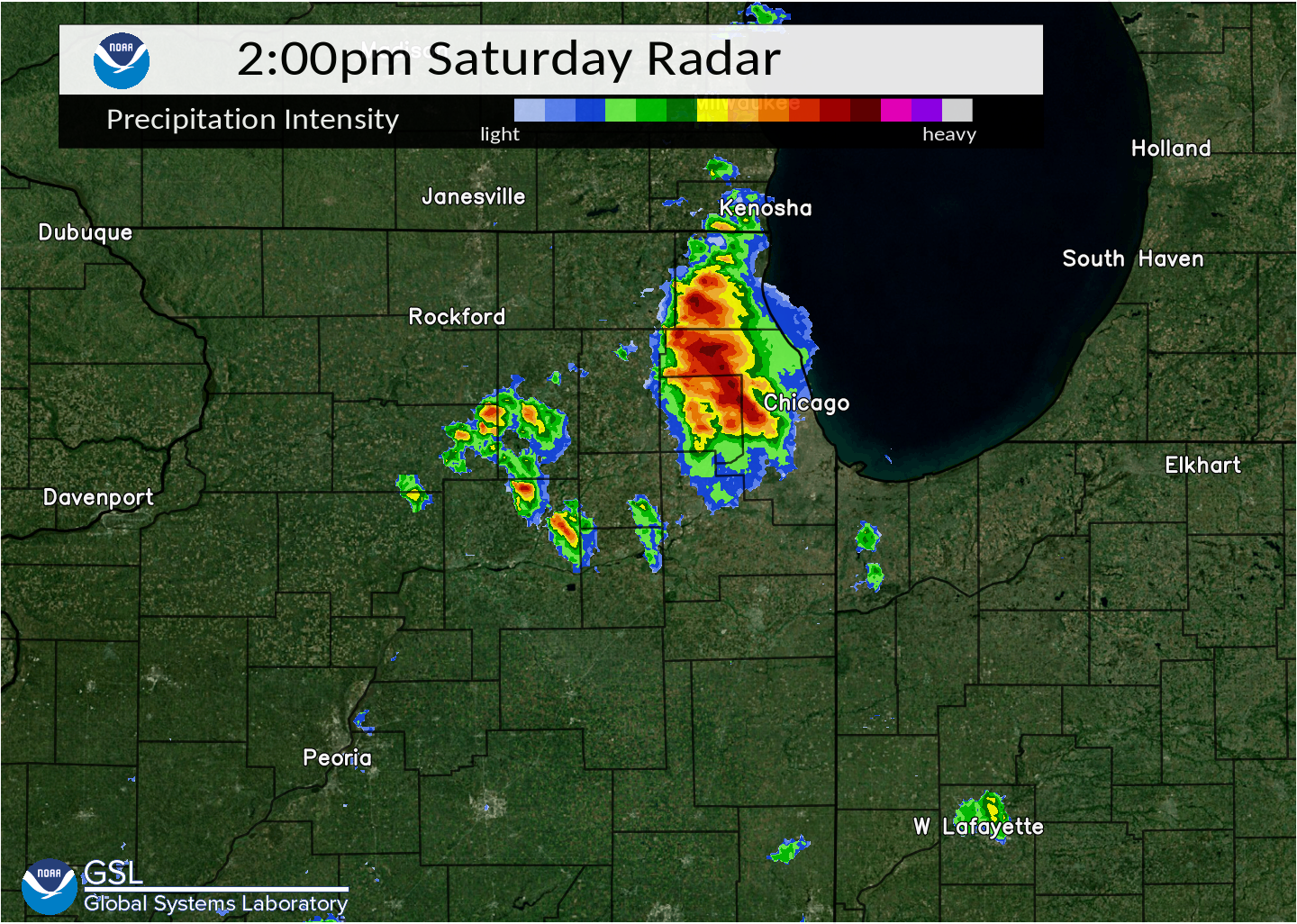
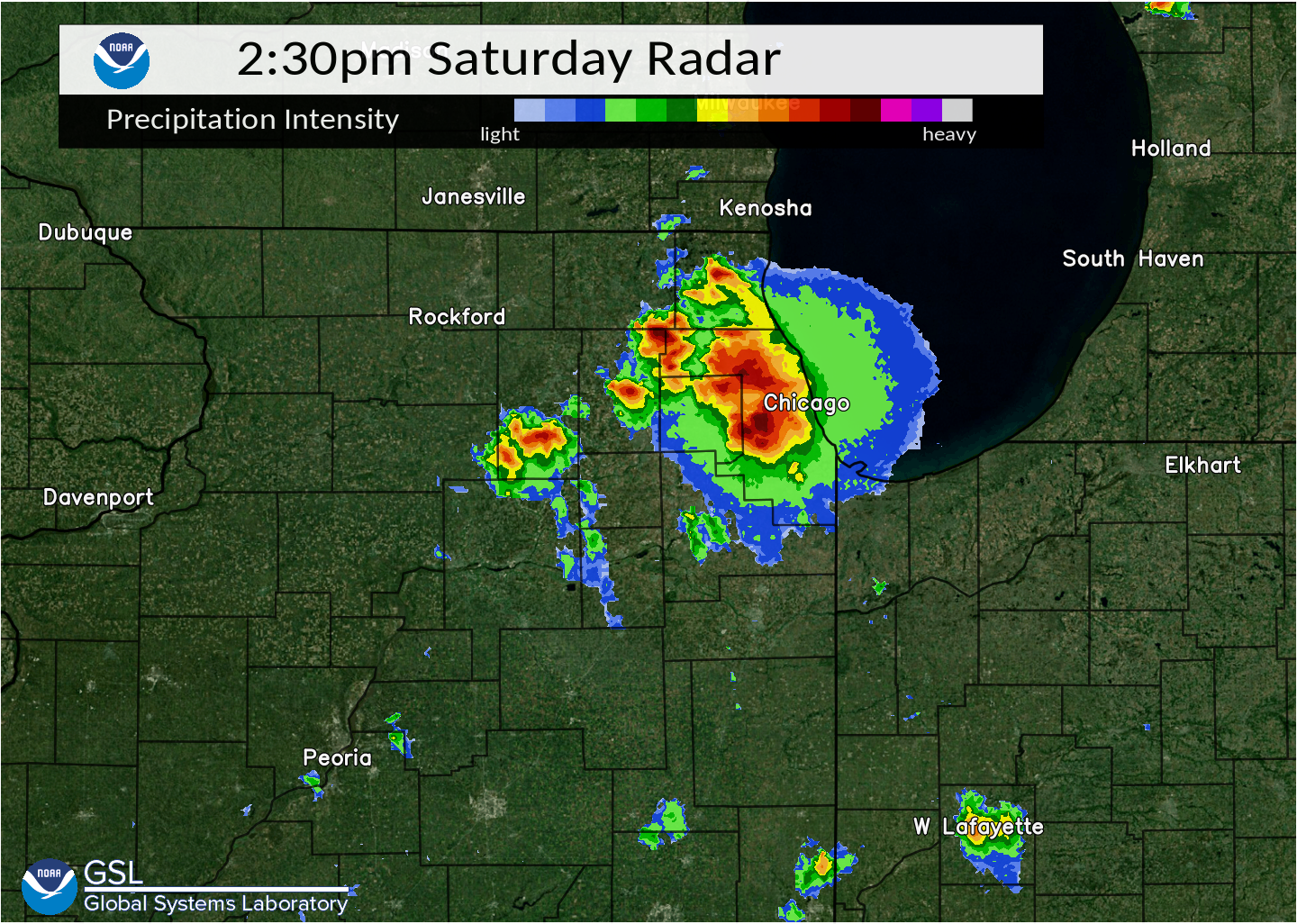
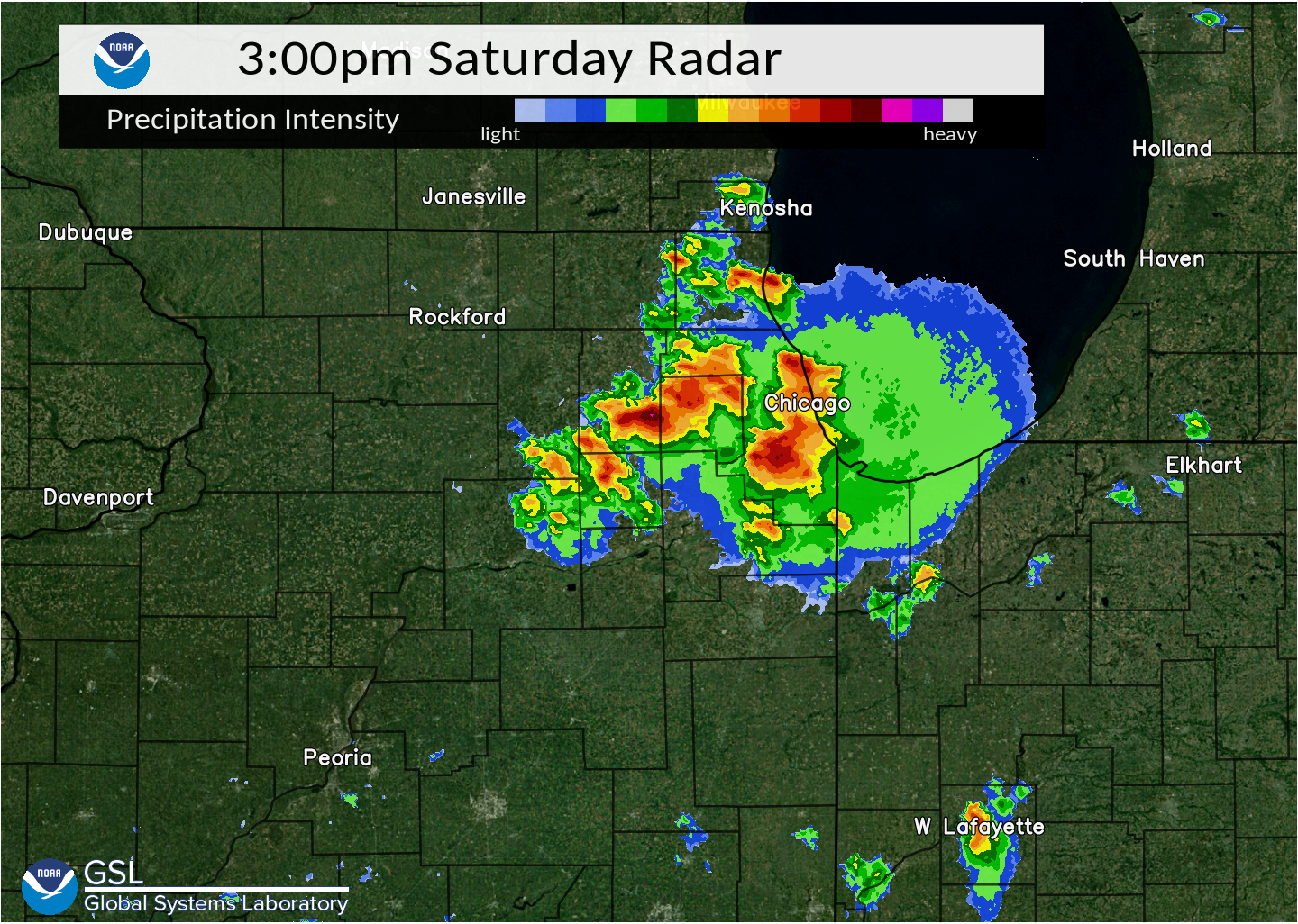
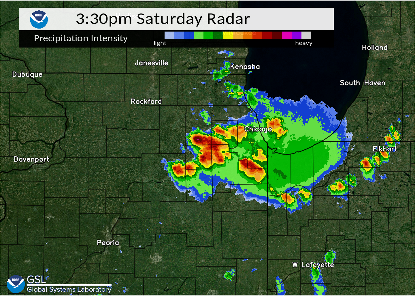
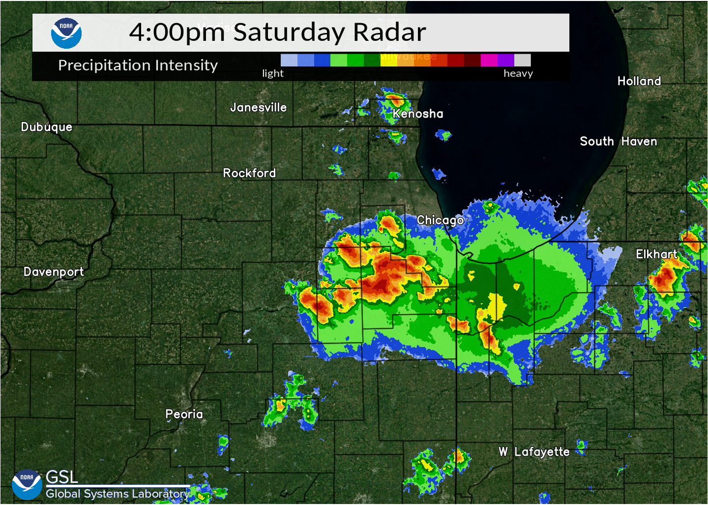
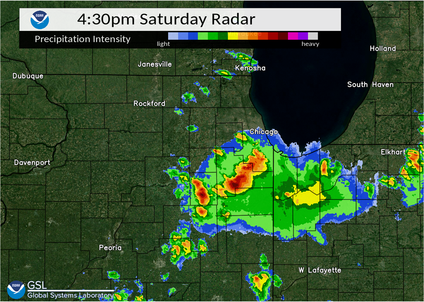
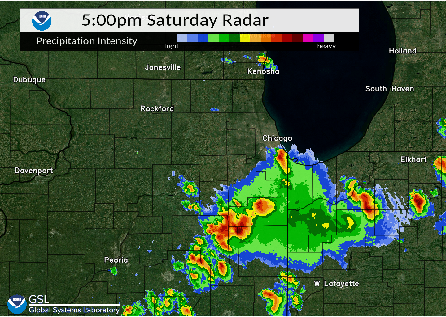
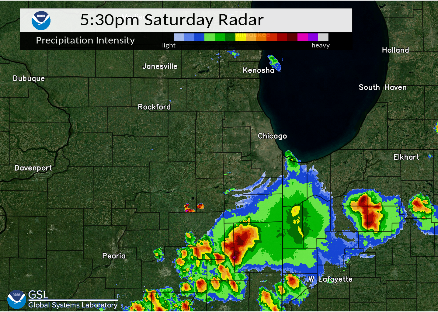
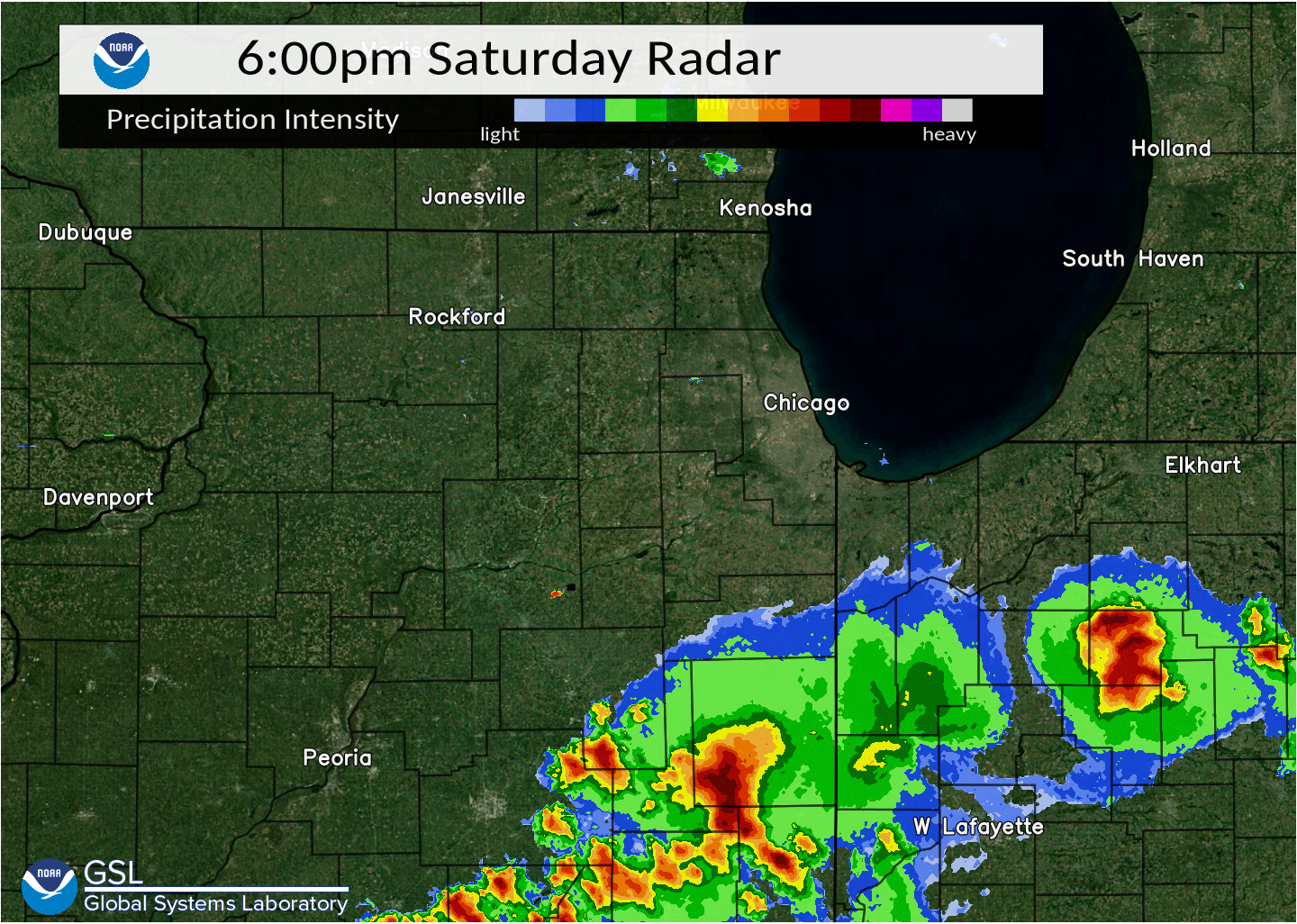
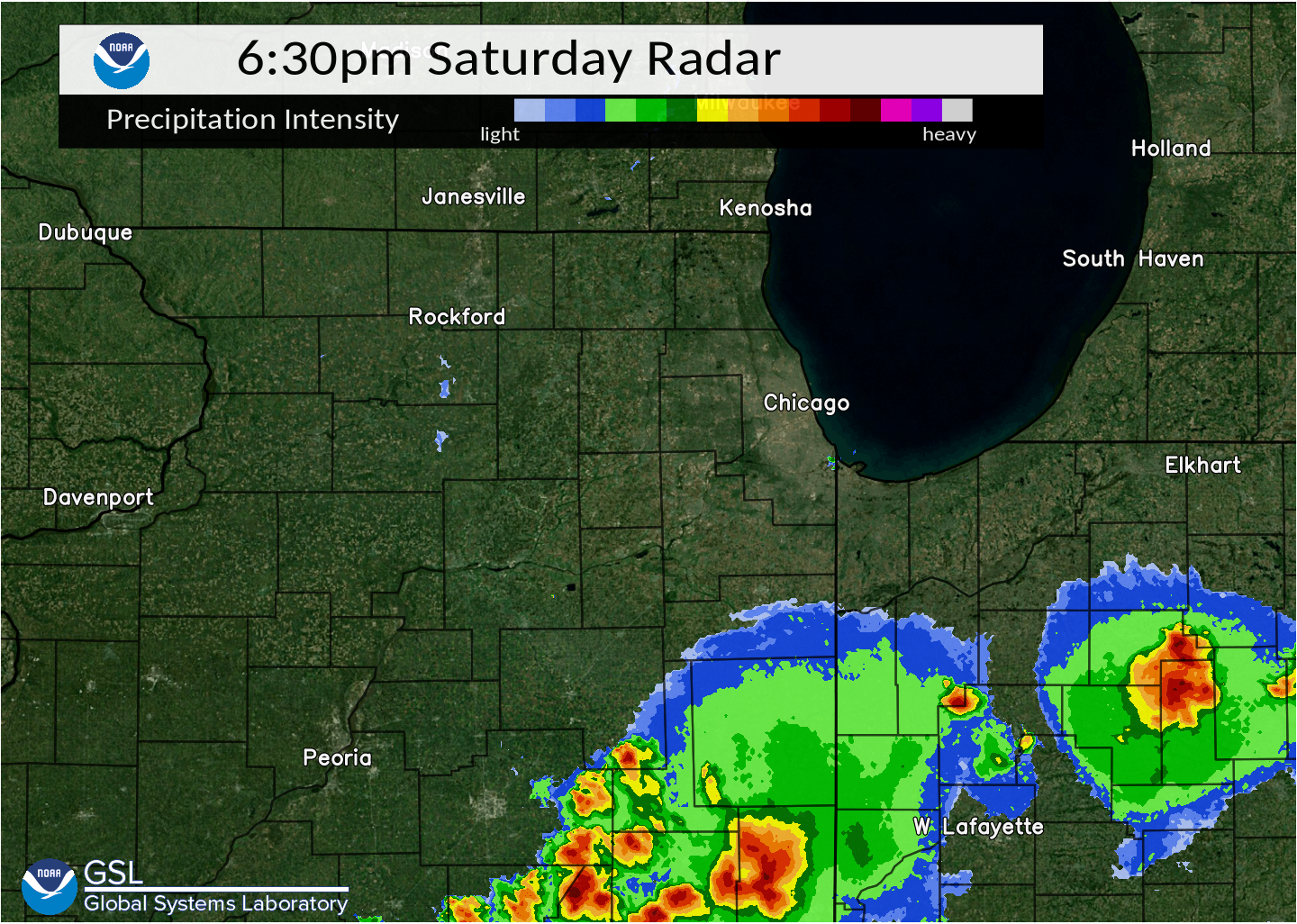
On June 11 and 12, 2021, scattered thunderstorms developed across northern Illinois leading to pockets of damaging winds, hail, and torrential rainfall. The worst severe weather struck Lindenwood on June 11 and Buckley on June 12 where in both locations, significant wind gusts in excess of 70 mph snapped trees and wind-driven hail pelted buildings. Finally, while some areas saw much-needed rainfall that amounted to over 1-2 inches, many others remained completely dry. Click through the tabs below for more information about the severe weather on June 11th and 12th, along with the two-day rainfall amounts..
June 11
 |
 |
PRELIMINARY LOCAL STORM REPORT...SUMMARY
NATIONAL WEATHER SERVICE CHICAGO IL
719 AM CDT SAT JUN 12 2021

..TIME...   ...EVENT...      ...CITY LOCATION...     ...LAT.LON...
..DATE...   ....MAG....      ..COUNTY LOCATION..ST.. ...SOURCE....
            ..REMARKS..

0326 PM     TSTM WND DMG     LINDENWOOD              42.05N 89.03W
06/11/2021                   OGLE               IL   EMERGENCY MNGR

            ROUGHLY EIGHT MILE SWATH OF TREE DAMAGE IN
            AND AROUND LINDENWOOD, WITH MULTIPLE PHOTOS
            OF LARGE AND HEALTHY TREES SNAPPED HALF WAY
            UP THE TRUNK. A LARGE OUTBUILDING WAS ALSO
            HEAVILY DAMAGED IN LINDENWOOD.

0326 PM     TSTM WND DMG     2 WSW MONROE CENTER     42.09N 89.03W
06/11/2021                   OGLE               IL   PUBLIC

            A 2 FOOT IN DIAMETER TREE WAS BLOWN DOWN AND
            IS NOW BLOCKING A ROAD 1 MILE SOUTH OF
            HIGHWAY 72. THE TREE APPEARED TO BE ROTTEN
            IN THE MIDDLE. TIME ESTIMATED BY RADAR.

0327 PM     TSTM WND DMG     LINDENWOOD              42.05N 89.03W
06/11/2021                   OGLE               IL   TRAINED SPOTTER

            AN APPROXIMATELY 60 FT COMMS TOWER WAS BLOWN
            DOWN. TIME ESTIMATED BY RADAR.

0152 PM     TSTM WND GST     2 W SUGAR GROVE         41.77N 88.48W
06/11/2021  M43 MPH          KANE               IL   ASOS

            ASOS STATION KARR SUGAR GROVE - AURORA ARPT.

0540 PM     HAIL             2 S MORRIS              41.33N 88.42W
06/11/2021  E0.70 INCH       GRUNDY             IL   STORM CHASER

            PEA TO DIME SIZE HAIL FALLING, AND LEAVES
            AND TWIGS BLOWN ONTO THE ROAD.

0344 PM     TSTM WND GST     3 SW CLARE              41.99N 88.88W
06/11/2021  M45 MPH          DE KALB            IL   PUBLIC

            PEAK WIND GUST FROM LOCAL MESONET STATION,
            ID KILMALTA3.

0352 PM     TSTM WND DMG     MALTA                   41.93N 88.86W
06/11/2021                   DE KALB            IL   LAW ENFORCEMENT

            POWER POLES LEANED OVER AND WIRES DOWNED DUE
            TO THE WIND. TIME ESTIMATED BY RADAR.

0415 PM     TSTM WND GST     1 NNW CORTLAND          41.93N 88.70W
06/11/2021  M48 MPH          DE KALB            IL   AWOS

            AWOS STATION KDKB DEKALB AIRPORT.

0428 PM     TSTM WND DMG     HINCKLEY                41.77N 88.64W
06/11/2021                   DE KALB            IL   LAW ENFORCEMENT

            TREE DOWNED ON WIRES.

0440 PM     HEAVY RAIN       3 SW CLARE              41.99N 88.88W
06/11/2021  M2.74 INCH       DE KALB            IL   PUBLIC

            1-HOUR RAINFALL FROM APPROXIMATELY 3:40 TO
            4:40 PM CDT. MESONET STATION ID KILMALTA3.
.
June 12
 |
 |
PRELIMINARY LOCAL STORM REPORT...SUMMARY
NATIONAL WEATHER SERVICE CHICAGO IL
911 PM CDT SAT JUN 12 2021

..TIME...   ...EVENT...      ...CITY LOCATION...     ...LAT.LON...
..DATE...   ....MAG....      ..COUNTY LOCATION..ST.. ...SOURCE....
            ..REMARKS..

0211 PM     HAIL             INVERNESS               42.11N 88.10W
06/12/2021  U0.75 INCH       COOK               IL   PUBLIC

            DIME SIZE HAIL REPORT FROM MPING.

0215 PM     HAIL             1 NE ELK GROVE VILLAGE  42.01N 87.98W
06/12/2021  E1.00 INCH       COOK               IL   PUBLIC

            NEAR ARLINGTON HEIGHTS RD AND LANDMEIER RD.

0220 PM     HAIL             CARPENTERSVILLE         42.12N 88.26W
06/12/2021  E1.25 INCH       KANE               IL   PUBLIC


0224 PM     TSTM WND GST     2 SE MEDINAH            41.95N 88.03W
06/12/2021  M61 MPH          DUPAGE             IL   TRAINED SPOTTER

            MEASURED USING HANDHELD METER.

0229 PM     HAIL             BENSENVILLE             41.95N 87.94W
06/12/2021  U0.88 INCH       DUPAGE             IL   TRAINED SPOTTER


0234 PM     HAIL             1 NNW CARPENTERSVILLE   42.13N 88.26W
06/12/2021  U0.75 INCH       KANE               IL   PUBLIC

            DIME SIZE HAIL REPORT FROM MPING.

0236 PM     HEAVY RAIN       2 E SCHAUMBURG          42.03N 88.04W
06/12/2021  M1.98 INCH       COOK               IL   COCORAHS

            40 MINUTE RAINFALL TOTAL.

0240 PM     HEAVY RAIN       BROOKFIELD              41.82N 87.85W
06/12/2021  M1.80 INCH       COOK               IL   PUBLIC

            30 MINUTE RAINFALL TOTAL.

0245 PM     TSTM WND GST     3 SW MIDWAY AIRPORT     41.74N 87.78W
06/12/2021  M65 MPH          COOK               IL   CO-OP OBSERVER


0248 PM     TSTM WND GST     MIDWAY AIRPORT          41.79N 87.75W
06/12/2021  M68 MPH          COOK               IL   ASOS


0250 PM     HAIL             1 NNW BATAVIA           41.87N 88.32W
06/12/2021  U0.75 INCH       KANE               IL   COCORAHS


0254 PM     HAIL             1 SSW GENEVA            41.87N 88.31W
06/12/2021  E1.25 INCH       KANE               IL   PUBLIC

            FROM PHOTO SHARED ON TWITTER. TIME ESTIMATED
            BASED ON RADAR.

0300 PM     HAIL             BATAVIA                 41.85N 88.31W
06/12/2021  M0.50 INCH       KANE               IL   TRAINED SPOTTER

            LARGEST HAILSTONES HALF AN INCH IN DIAMETER.

0310 PM     HEAVY RAIN       3 SW MIDWAY AIRPORT     41.74N 87.78W
06/12/2021  M1.10 INCH       COOK               IL   CO-OP OBSERVER

            40 MINUTE RAINFALL TOTAL.

0316 PM     HAIL             2 SW RICHTON PARK       41.46N 87.76W
06/12/2021  U0.75 INCH       WILL               IL   PUBLIC

            DIME SIZE HAIL REPORT FROM MPING.

0330 PM     HEAVY RAIN       WOOD DALE               41.96N 87.98W
06/12/2021  M2.20 INCH       DUPAGE             IL   PUBLIC


0330 PM     HEAVY RAIN       0.6 ESE ELK GROVE VILLA 42.00N 87.98W
06/12/2021  M2.49 INCH       COOK               IL   COCORAHS

            MINOR STREET FLOODING AND STANDING WATER.

0336 PM     HAIL             3 NW MONTGOMERY         41.76N 88.38W
06/12/2021  U0.50 INCH       KANE               IL   PUBLIC

            HALF-INCH HAIL REPORT FROM MPING.

0338 PM     HAIL             3 SW NORTH AURORA       41.78N 88.38W
06/12/2021  E1.00 INCH       KANE               IL   TRAINED SPOTTER

            NICKEL TO QUARTER SIZE HAIL.

0340 PM     HAIL             3 WNW AURORA            41.77N 88.36W
06/12/2021  M0.75 INCH       KANE               IL   EMERGENCY MNGR


0341 PM     HAIL             3 SE SUGAR GROVE        41.73N 88.40W
06/12/2021  E0.50 INCH       KANE               IL   TRAINED SPOTTER


0515 PM     TSTM WND DMG     2 NNW DANFORTH          40.85N 87.99W
06/12/2021                   IROQUOIS           IL   LAW ENFORCEMENT

            BOX TRUCK BLOWN OVER ON I-57 NEAR MILE
            MARKER 290. NO INJURIES PER ISP.

0517 PM     TSTM WND GST     CHATSWORTH              40.75N 88.29W
06/12/2021  M48 MPH          LIVINGSTON         IL   CO-OP OBSERVER

            HEAVY RAINFALL WITH POOR VISIBILITY.

0544 PM     TSTM WND DMG     3 W BUCKLEY             40.59N 88.10W
06/12/2021                   IROQUOIS           IL   TRAINED SPOTTER

            10 POWER POLES SNAPPED NEAR THEIR BASE ON
            COUNTY ROAD 700N WEST OF I-57, CONFIRMED BY
            VIDEO RELAYED VIA SOCIAL MEDIA.

0545 PM     TSTM WND DMG     1 SE BUCKLEY            40.59N 88.03W
06/12/2021                   IROQUOIS           IL   TRAINED SPOTTER

            PHOTO OF A LARGE HEALTHY TREE SNAPPED AT THE
            TRUNK JUST EAST OF BUCKLEY.

0545 PM     TSTM WND DMG     BUCKLEY                 40.60N 88.04W
06/12/2021                   IROQUOIS           IL   BROADCAST MEDIA

            LARGE TREE DOWNED IN BUCKLEY. POWER OUTAGES
            REPORTED IN THE AREA.

0547 PM     TSTM WND GST     2 NNW CISSNA PARK       40.59N 87.91W
06/12/2021  M75 MPH          IROQUOIS           IL   MESONET

            MEASURED BY A PERSONAL WEATHER STATION NORTH
            OF CISSNA PARK.

0550 PM     HAIL             2 WNW BUCKLEY           40.61N 88.07W
06/12/2021  E1.25 INCH       IROQUOIS           IL   BROADCAST MEDIA
.
Two-Day Rainfall
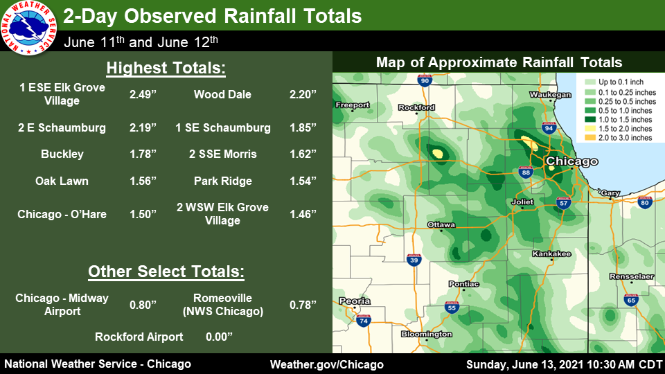 |
PUBLIC INFORMATION STATEMENT
NATIONAL WEATHER SERVICE CHICAGO/ROMEOVILLE IL
1015 AM CDT SUN JUN 13 2021

...2-DAY RAINFALL ROUND-UP...

THE FOLLOWING ARE RAINFALL AMOUNTS FOR THE PREVIOUS 2 DAYS
AS MEASURED IN THE MORNING BY NWS COOPERATIVE OBSERVERS AND
COCORAHS OBSERVERS. OBSERVATIONS ARE USUALLY TAKEN AT 7 AM.


2-DAY RAIN TOTALS FOR FRIDAY (06/11/21) AND SATURDAY (06/12/21)

ILLINOIS                                 2-DAY RAINFALL
  LOCATION (COUNTY):                        AMT(INCHES) REPORTS

  ELK GROVE VILLAGE 1ESE (COOK)................2.49     (2)
  SCHAUMBURG 2E (COOK).........................2.19     (2)
  SCHAUMBURG 1SE (COOK)........................1.85     (2)
  BUCKLEY (IROQUOIS)...........................1.78     (1)
  MORRIS 2SSE (GRUNDY).........................1.62     (2)
  OAK LAWN (COOK)..............................1.56     (1)
  PARK RIDGE (COOK)............................1.54     (1)
  O'HARE AIRPORT (COOK).........................1.5     (1)
  ELK GROVE VILLAGE 2WSW (COOK)................1.46     (2)
  COUNTRYSIDE 1ENE (COOK)......................1.45     (2)
  BRIDGEVIEW 1NNW (COOK).......................1.42     (1)
  HARWOOD HEIGHTS (COOK)........................1.4     (1)
  MORRIS (GRUNDY)..............................1.35     (1)
  AURORA (KANE)................................1.29     (1)
  MIDWAY COOP (COOK)...........................1.25     (1)
  LA GRANGE PARK 1SSW (COOK)...................1.17     (2)
  HOFFMAN ESTATES 2SE (COOK)...................1.17     (1)
  DEKALB (DE KALB).............................1.15     (1)
  LOMBARD 1NNW (DU PAGE)........................1.1     (2)
  OAK LAWN 2WNW (COOK).........................1.02     (1)
  AURORA 4NE (DU PAGE).........................1.01     (1)
  AURORA 4SE (DU PAGE).........................1.01     (1)
  ELMHURST 1ESE (DU PAGE)......................0.98     (1)
  OAK PARK 2S (COOK)...........................0.98     (1)
  MUNDELEIN (LAKE).............................0.96     (1)
  SUGAR GROVE 1NE (KANE).......................0.96     (2)
  MORRIS 5NNW (GRUNDY).........................0.94     (2)
  OAK LAWN 2SE (COOK)..........................0.92     (1)
  MONTGOMERY 1SSE (KENDALL)....................0.91     (1)
  ELMHURST (DU PAGE)...........................0.88     (2)
  CHICAGO RIDGE (COOK).........................0.88     (1)
  NAPERVILLE 4SSW (WILL).......................0.87     (1)
  OAK PARK 1SW (COOK)..........................0.87     (1)
  ELMHURST 2SE (DU PAGE).......................0.86     (2)
  LAKE ZURICH 1N (LAKE)........................0.85     (1)
  SUGAR GROVE 1ENE (KANE)......................0.82     (2)
  MIDWAY (COOK).................................0.8     (1)
  BARRINGTON (LAKE).............................0.8     (1)
  ROMEOVILLE (WILL)............................0.78     (2)
  BATAVIA (KANE)...............................0.78     (2)
  WHEATON 2NNE (DU PAGE).......................0.76     (2)
  VILLA PARK 1NW (DU PAGE).....................0.72     (1)
  ROMEOVILLE (WILL)............................0.66     (1)
  MANHATTAN 2SE (WILL).........................0.66     (1)
  LOCKPORT 1SE (WILL)..........................0.63     (1)
  PALOS PARK 1SW (COOK)........................0.61     (1)
  WEST CHICAGO (DU PAGE).......................0.61     (2)
  PARK FOREST (COOK)............................0.6     (1)
  CHANNAHON 2SSE (WILL).........................0.6     (1)
  CORTLAND (DE KALB)............................0.6     (1)
  OAK PARK 1NNE (COOK).........................0.57     (1)
  BRANDON ROAD LOCK & DAM (WILL)...............0.56     (1)
  JOLIET 2N (WILL).............................0.56     (1)
  NEW LENOX 3E (WILL)..........................0.56     (1)
  EARLVILLE 5NNE (DE KALB).....................0.55     (2)
  NEW LENOX 2SE (WILL).........................0.53     (2)
  CARBON HILL 3.1N (GRUNDY)....................0.52     (2)
  COAL CITY 4NNW (GRUNDY)......................0.52     (2)
  MARSEILLES LOCK & DAM (LA SALLE).............0.51     (1)
  PLAINFIELD 5SW (KENDALL).....................0.51     (2)
  MORRIS (GRUNDY)..............................0.51     (2)
  LAKE ZURICH (LAKE)............................0.5     (1)
  GENEVA 1SSW (KANE)............................0.5     (2)

$$
Additional Information
 |
Media use of NWS Web News Stories is encouraged! Please acknowledge the NWS as the source of any news information accessed from this site. Additional recaps can be found on the NWS Chicago Past Events Page |
|

