
Severe thunderstorms will be possible from the central Plains to the Mid-Atlantic and Northeast on Monday. Hazardous heat will linger across the southern U.S. and build across the West through mid-week. Hot and dry conditions will fuel fire weather concerns for Interior Alaska and the Four Corners region through Monday. Read More >
Overview
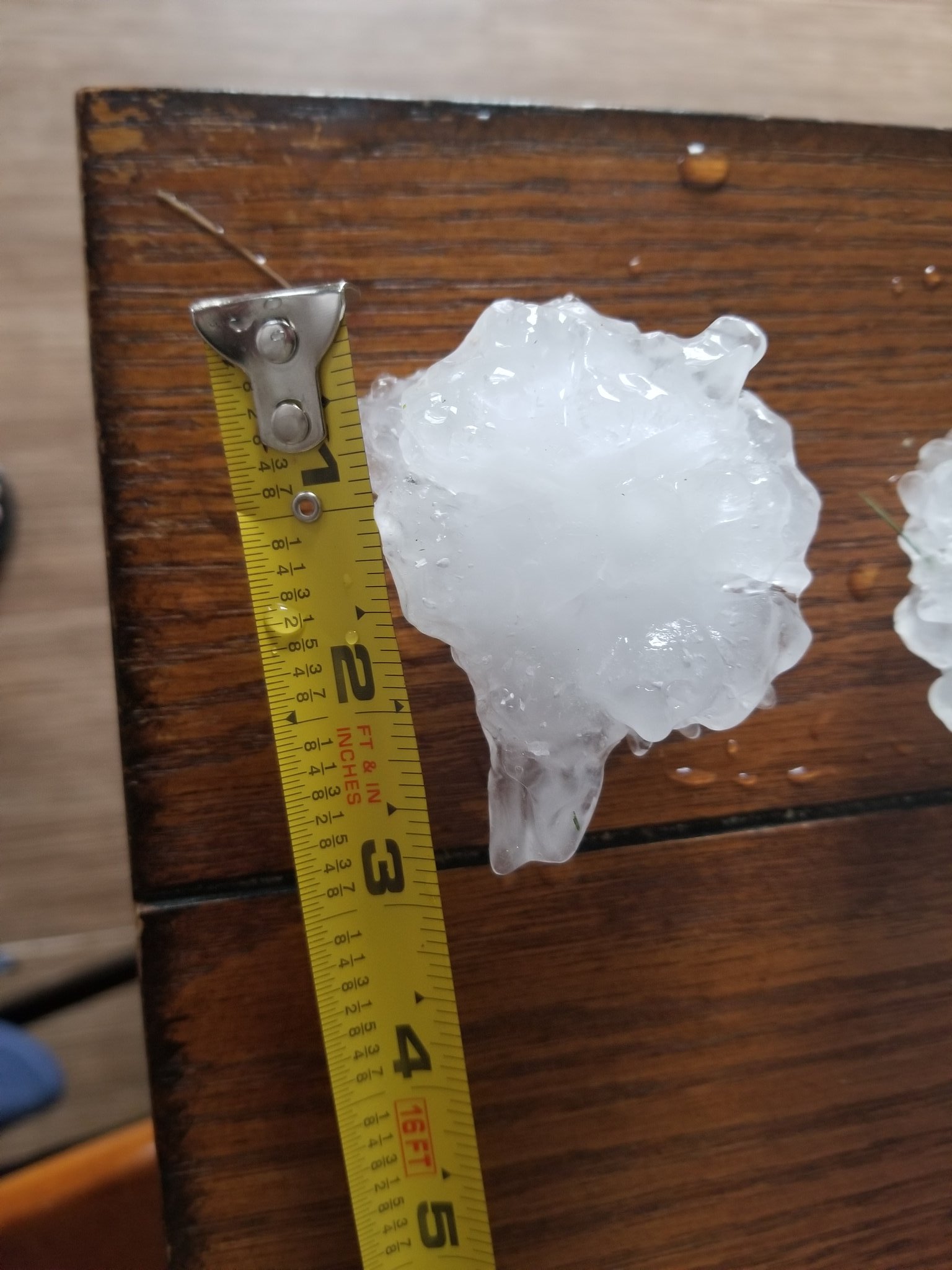
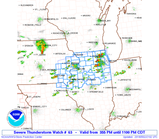
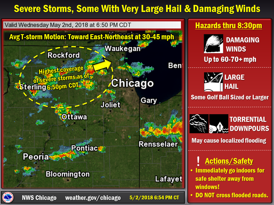
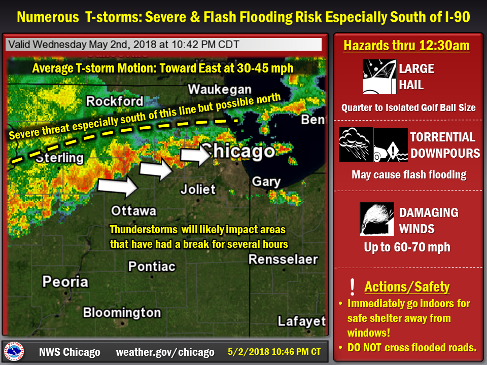
Temperatures in the mid 80s and gulf moisture led to a very unstable atmosphere on Wednesday. An upper level wave and forcing ahead of a slow moving cold front initiated storms across the Midwest, including numerous severe storms across Northern Illinois and Northwest Indiana. The strongest storms produced 2-3" diameter hail near Rockford, and a 67 MPH wind gust at Midway Airport, with significant wind damage near Midway. In addition, significant wind damage occurred in parts of northern Kankakee County and central Lake County Indiana. After a brief break in storms, a line of storms brought large hail up to 2-2.5" diameter to northern Lake and McHenry Counties, and heavy rain to areas mainly north of I-80.
Wind & Hail:
Wind
 |
 |
 |
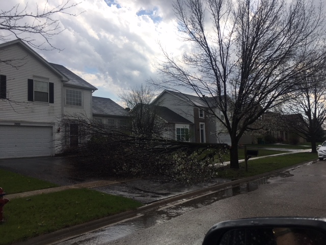 |
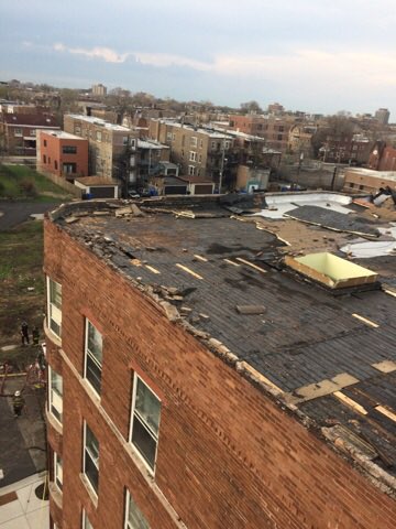
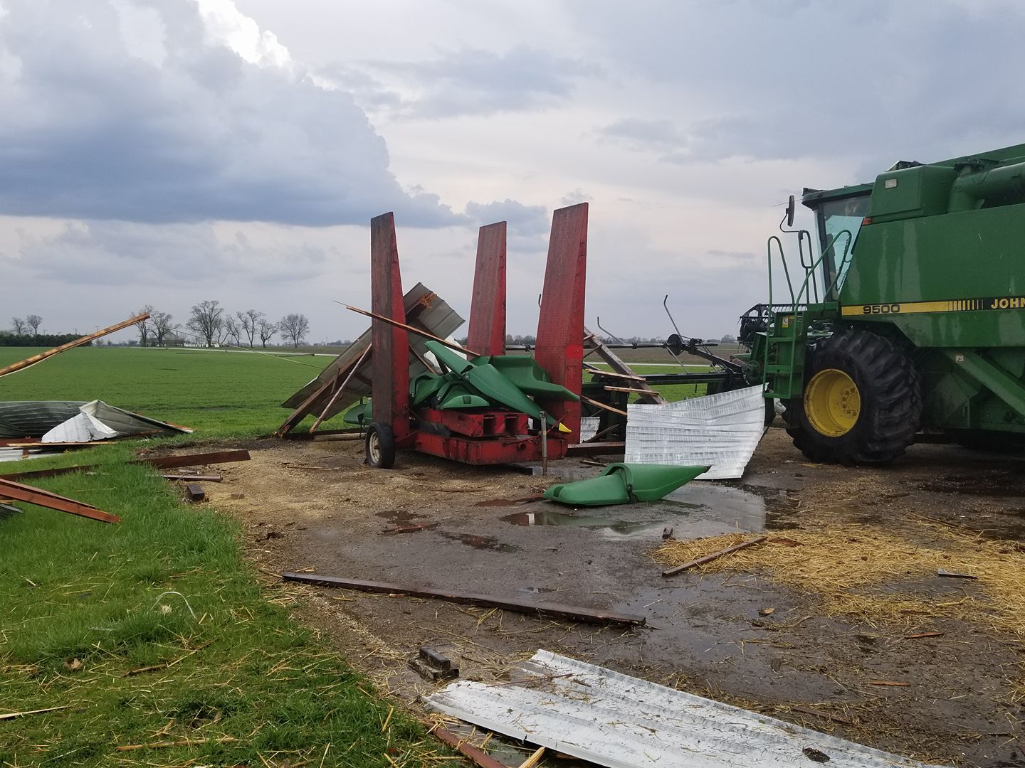
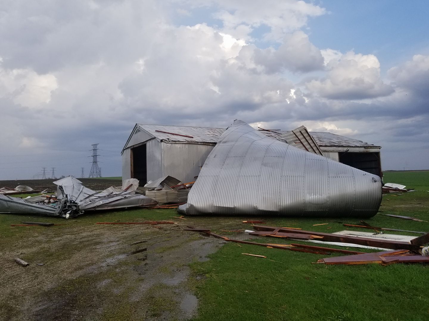
| Apartment Building damage near Washington Park, Chicago, IL - Photo from Chicago Fire Department | Wind damage near Manteno,IL - Photo from Patrick Pahl | Wind damage near Manteno, IL - Photo from Patrick Pahl | Wind damage in Plainfield, IL - Photo from JoAnna Green |
Hail
 |
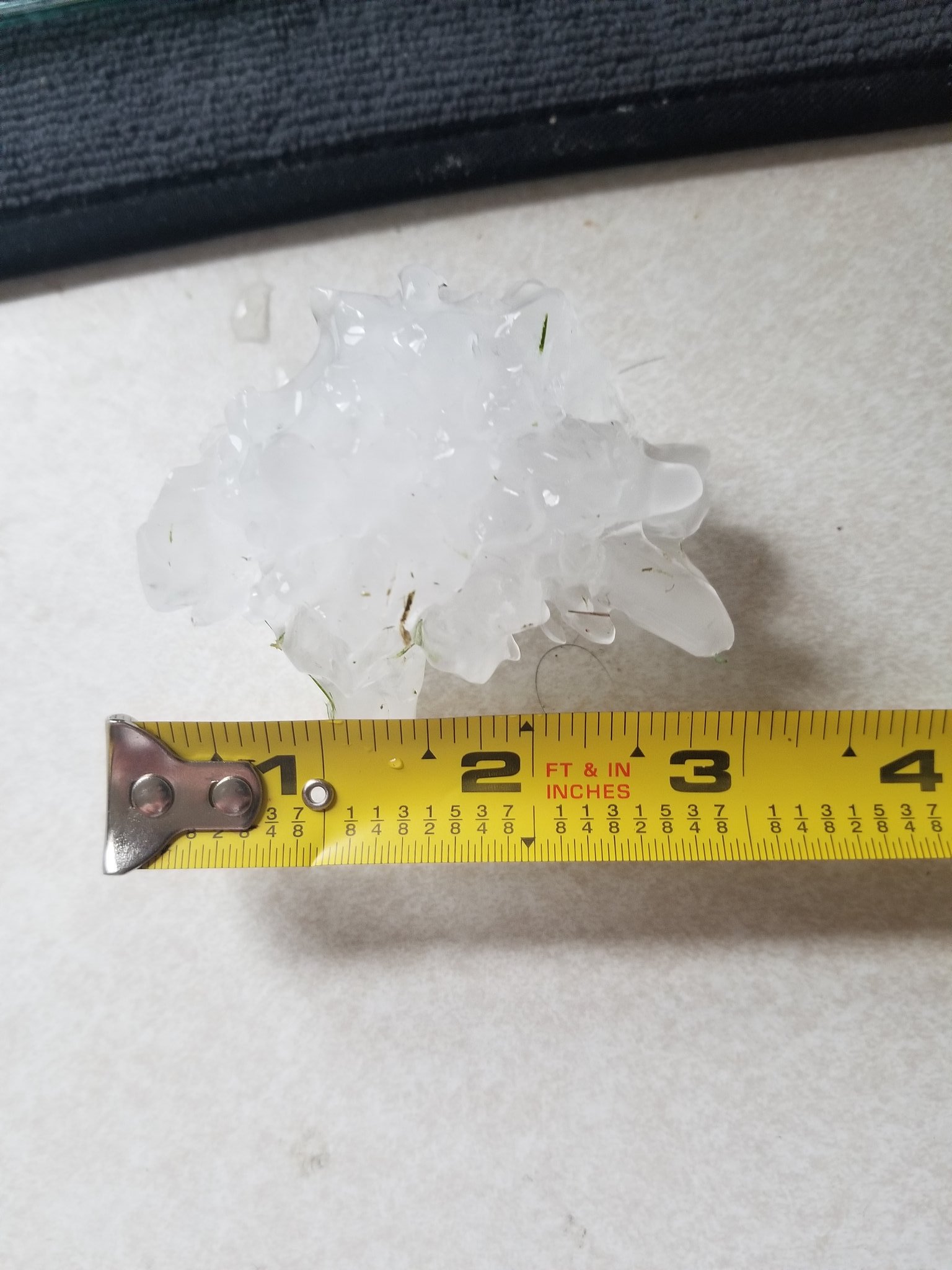 |
| 2.5 inch hail near Rockford | 3 inch heal near Rockford - Photo from Justin Kink |
Flooding
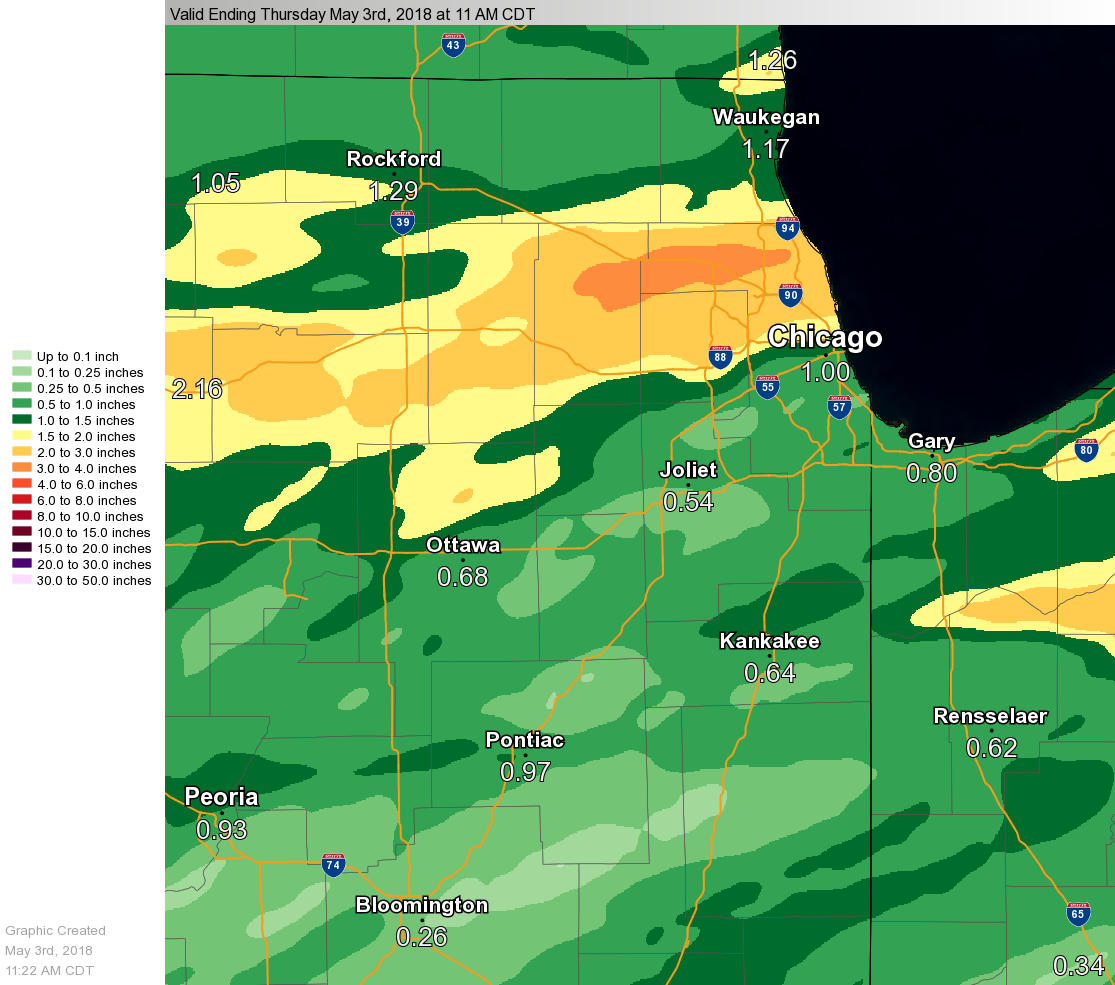
Rainfall totals over the past 24-hours
Public Information Statement
National Weather Service Chicago IL
1031 AM CDT Thu May 03 2018

...Morning Rainfall Roundup...

   The following are rain amounts for the previous 24-hours
   as measured in the morning by NWS Cooperative Observers
   and CoCoRaHS observers.
   Observations are usually taken between 6 AND 8 AM.

   24-hour rainfall amounts
       for Thursday(05/03/18)...


Illinois                                       Rain
  Location (County):                           fall (inches)

  Barrington (Lake)............................2.83
  Elgin (Kane).................................2.79
  Elgin 1S (Kane)..............................2.79
  Streamwood (Cook)............................2.78
  Arlington Heights 1SW (Cook).................2.67
  Elmwood Park 1ESE (Cook).....................2.62
  Elgin (Kane).................................2.55
  Elmhurst 1ESE (Du Page)......................2.55
  Evanston 1N (Cook)...........................2.47
  Roselle 1ESE (Du Page).......................2.47
  Mount Prospect 3NE (Cook)....................2.46
  Palatine 1NNE (Cook).........................2.43
  Wheeling (Cook)..............................2.43
  Elk Grove Village 1ESE (Cook)................2.37
  Botanic Gardens (Cook).......................2.36
  Schaumburg 2E (Cook).........................2.36
  St. Charles (Kane)...........................2.27
  Hoffman Estates 5W (Cook)....................2.25
  Elk Grove Village 2WSW (Cook)................2.25
  Carol Stream (Du Page).......................2.25
  Glencoe (Cook)...............................2.23
  Elgin 2WNW (Kane)............................2.23
  Park Ridge 1WNW (Cook).......................2.18
  Elgin 8WSW (Kane)............................2.14
  Harwood Heights (Cook).......................2.11
  Elmhurst 2SE (Du Page).......................2.11
  Elmhurst (Du Page)...........................2.11
  Lincolnwood 2E (Cook)........................2.09
  Batavia 1WSW (Kane)..........................2.06
  Lily Lake 2E (Kane)..........................2.05
  Gilberts (Kane)..............................2.04
  Elgin 2W (Kane)..............................2.03
  Geneva 4WSW (Kane)...........................2.00
  Elburn (Kane)................................2.00
  Rogers Park 2SW (Cook).......................1.97
  Batavia 2WNW (Kane)..........................1.95
  Batavia 1WNW (Kane)..........................1.95
  De Kalb (De Kalb)............................1.94
  Elburn (Kane)................................1.94
  Geneva 1SSW (Kane)...........................1.93
  Dixon 3NNW (Lee).............................1.91
  Aurora (Kane)................................1.90
  Glen Ellyn 1NNW (Du Page)....................1.86
  De Kalb 1SW (De Kalb)........................1.84
  Ohare (Cook).................................1.84
  St. Charles 6NW (Kane).......................1.83
  Oak Park 1NNE (Cook).........................1.82
  De Kalb (De Kalb)............................1.81
  Wheaton 2NNE (Du Page).......................1.81
  Dixon (Lee)..................................1.79
  Amboy (Lee)..................................1.77
  Ashton (Lee).................................1.74
  Chicago 6NNE (Cook)..........................1.68
  Sugar Grove 1NE (Kane).......................1.68
  Villa Park 1NW (Du Page).....................1.67
  Park Ridge (Cook)............................1.66
  Sugar Grove 1ENE (Kane)......................1.63
  Rochelle (Ogle)..............................1.57
  Steward (Lee)................................1.56
  Lombard 1NNW (Du Page).......................1.55
  Cary (McHenry)...............................1.51
  Batavia (Kane)...............................1.50
  West Chicago (Du Page).......................1.50
  Winnetka 1ESE (Cook).........................1.47
  Dekalb (De Kalb).............................1.45
  North Aurora 2NE (Kane)......................1.44
  Glen Ellyn 1WSW (Du Page)....................1.42
  Riverwoods (Lake)............................1.41
  Cary (McHenry)...............................1.35
  Lisle Morton Arb (Du Page)...................1.34
  Beecher 3ENE (Will)..........................1.31
  Paw Paw (Lee)................................1.27
  Aurora (Kane)................................1.25
  Downers Grove 0.4NNE (Du Page)...............1.22
  Naperville 1NW (Du Page).....................1.21
  Aurora 4SE (Du Page).........................1.20
  Naperville 2SE (Du Page).....................1.20
  Genoa (De Kalb)..............................1.18
  Berwyn 1NW (Cook)............................1.16
  Bannockburn (Lake)...........................1.16
  Naperville 2ESE (Du Page)....................1.15
  Highwood 1S (Lake)...........................1.15
  Naperville 2ESE (Du Page)....................1.12
  Mendota (La Salle)...........................1.12
  Earlville 3S (La Salle)......................1.11
  Oak Park 2S (Cook)...........................1.11
  Earlville 5NNE (De Kalb).....................1.11
  Lisle 1SW (Du Page)..........................1.10
  Somonauk 2NE (De Kalb).......................1.09
  Cortland (De Kalb)...........................1.07
  Lake in the Hills 2.5W (McHenry).............1.07
  Rochelle (Ogle)..............................1.07
  Aurora 4SE (Du Page).........................1.05
  Crystal Lake 1WSW (McHenry)..................1.05
  Algonquin 1N (McHenry).......................1.03
  Homewood (Cook)..............................1.02
  Yorkville 2SE (Kendall)......................1.02
  Plano (Kendall)..............................1.01
  North Utica 6N (La Salle)....................1.01
  Lake Zurich 1N (Lake)........................1.00
  Buffalo Grove 2N (Lake)......................0.98
  Westmont (Du Page)...........................0.98
  Chicago 5NE (Cook)...........................0.97
  Lake Zurich (Lake)...........................0.97
  Downers Grove 1S (Du Page)...................0.95
  Huntley (McHenry)............................0.95
  Waukegan (Lake)..............................0.93
  Montgomery 1SSE (Kendall)....................0.92
  Mendota (La Salle)...........................0.92
  Byron 3N (Ogle)..............................0.91
  Mundelein (Lake).............................0.91
  Sheridan 3SSE (La Salle).....................0.90
  Crete 3E (Will)..............................0.90
  Lansing (Cook)...............................0.90
  Rockford 1NW (Winnebago).....................0.87
  Lockport 1SE (Will)..........................0.86
  Rockford 2ENE (Winnebago)....................0.84
  Monee (Will).................................0.82
  Chicago 6ESE (Cook)..........................0.80
  Lake Bluff 1W (Lake).........................0.80
  Peru 1SW (La Salle)..........................0.80
  Rockford 3NE (Winnebago).....................0.80
  Rockford (Winnebago).........................0.80
  Libertyville 2ESE (Lake).....................0.79
  Lansing (Cook)...............................0.78
  Mundelein 2WNW (Lake)........................0.77
  Westmont 1SSW (Du Page)......................0.76
  Countryside 1ENE (Cook)......................0.75
  Waukegan 2N (Lake)...........................0.75
  Oglesby 1ESE (La Salle)......................0.75
  Belvidere (Boone)............................0.74
  Flossmoor (Cook).............................0.74
  Midlothian 1SE (Cook)........................0.74
  Winthrop Harbor (Lake).......................0.73
  Peru (La Salle)..............................0.73
  Mundelein (Lake).............................0.72
  Gurnee 2NE (Lake)............................0.71
  Zion (Lake)..................................0.71
  Oak Lawn 2SE (Cook)..........................0.70
  Momence (Kankakee)...........................0.70
  Bourbonnais (Kankakee).......................0.69
  Marseilles (La Salle)........................0.69
  Channahon 2SSE (Will)........................0.68
  Naperville 3SE (Du Page).....................0.67
  Manteno 2NW (Kankakee).......................0.67
  Peotone (Will)...............................0.67
  Pontiac (Livingston).........................0.66
  Gurnee 2W (Lake).............................0.65
  Midlothian (Cook)............................0.64
  La Grange Park 1SSW (Cook)...................0.64
  Coal City 3N (Grundy)........................0.64
  Winthrop Harbor 1SSW (Lake)..................0.64
  McHenry (McHenry)............................0.64
  Dwight 4NNW (Grundy).........................0.61
  Peru 1ENE (La Salle).........................0.61
  Plainfield 2SSE (Will).......................0.61
  Minooka (Grundy).............................0.60
  Mazon 0.5ENE (Grundy)........................0.59
  Harvard (McHenry)............................0.58
  Wilmington 6NW (Will)........................0.57
  Morris 2N (Grundy)...........................0.56
  Oak Lawn (Cook)..............................0.55
  Roscoe 2ESE (Winnebago)......................0.54
  Machesney Park 3ENE (Winnebago)..............0.54
  Roscoe 2se (Winnebago).......................0.54
  Capron (Boone)...............................0.53
  Streator (Livingston)........................0.53
  Woodstock 5nw (McHenry)......................0.53
  La Salle (La Salle)..........................0.52
  Woodstock 4SW (McHenry)......................0.52
  Lakemoor 2NW (McHenry).......................0.52
  Coal City 4NNW (Grundy)......................0.51
  Carbon Hill 3.1N (Grundy)....................0.51
  Morris 6ESE (Grundy).........................0.51
  Morris (Grundy)..............................0.51
  Channahon 1NNE (Will)........................0.50
  Hebron (McHenry).............................0.49
  Morris 2SSE (Grundy).........................0.49
  Fox Lake 2SE (Lake)..........................0.49
  Ashkum 5.6E (Iroquois).......................0.48
  Kankakee 4WNW (Kankakee).....................0.48
  Lake Villa 2WSW (Lake).......................0.48
  Bull Valley 2WNW (McHenry)...................0.48
  Plainfield 3ESE (Will).......................0.48
  St Anne (Kankakee)...........................0.48
  Darien (Du Page).............................0.47
  Pontiac 1SE (Livingston).....................0.47
  Joliet 2n (Will).............................0.47
  Worth (Cook).................................0.46
  Woodstock 1SSW (McHenry).....................0.46
  Joliet Lock/dam (Will).......................0.46
  Kankakee (Kankakee)..........................0.46
  Palos Park 1SW (Cook)........................0.45
  Park Forest 1NNE (Cook)......................0.45
  Emington 2SSE (Livingston)...................0.45
  Midway (Cook)................................0.45
  Woodstock 1SW (McHenry)......................0.44
  Plainfield (Will)............................0.44
  Park Forest (Cook)...........................0.43
  Morris 5NNW (Grundy).........................0.42
  Oswego 5SSE (Kendall)........................0.42
  Wonder Lake 1WNW (McHenry)...................0.42
  Midway Coop (Cook)...........................0.42
  Chebanse (Kankakee)..........................0.41
  Ottawa 1NW (La Salle)........................0.41
  Ottawa 2N (La Salle).........................0.41
  Pistakee Highlands (McHenry).................0.41
  Homer Glen 1ENE (Will).......................0.41
  Ottawa (La Salle)............................0.40
  Wonder Lake 1NE (McHenry)....................0.39
  Oak Lawn 2WNW (Cook).........................0.38
  Cissna Park 1S (Iroquois)....................0.38
  Elwood 5NE (Will)............................0.38
  Manhattan 2SE (Will).........................0.38
  Chicago Ridge (Cook).........................0.36
  Manhattan 5ENE (Will)........................0.36
  Joliet (Will)................................0.35
  Manhattan (Will).............................0.35
  Paxton (Ford)................................0.34
  Herscher 3E (Kankakee).......................0.34
  Wilmington 3SE (Will)........................0.34
  Romeoville (Will)............................0.33
  Burr Ridge 2SW (Du Page).....................0.32
  Seneca 1NNE (La Salle).......................0.31
  New Lenox 3ENE (Will)........................0.31
  Momence 6SSW (Kankakee)......................0.30
  Willow Springs (Cook)........................0.30
  Morris (Grundy)..............................0.29
  Paxton (Ford)................................0.29
  Seneca 2SSW (La Salle).......................0.28
  Manhattan 1ESE (Will)........................0.28
  Kankakee (Kankakee)..........................0.27
  Bridgeview 1NNW (Cook).......................0.26
  Streator 4ENE (La Salle).....................0.26
  Palos Park 4WNW (Cook).......................0.25
  New Lenox 2SE (Will).........................0.25
  Gibson 6NE (Ford)............................0.22
  New Lenox 3E (Will)..........................0.22
  Chatsworth (Livingston)......................0.20
  Fairbury (Livingston)........................0.20
  Chatsworth (Livingston)......................0.20
  Buckley (Iroquois)...........................0.16
  Gibson 3WNW (Ford)...........................0.14
  Dwight (Livingston)..........................0.10
  Watseka 6.9WNW (Iroquois)....................0.09
  Watseka (Iroquois)...........................0.08
  Cropsey 1NE (Livingston).....................0.03

Indiana                                        Rain
  Location (County):                           fall (inches)

  Wheatfield 5W (Jasper).......................1.62
  Valparaiso 7WSW (Porter).....................1.54
  Winfield 1NE (Lake)..........................1.51
  De Motte 1NNW (Jasper).......................1.41
  Crown Point 2WSW (Lake)......................1.29
  Valparaiso 6WSW (Porter).....................1.29
  Hebron 1NW (Porter)..........................1.23
  Valparaiso 1NE (Porter)......................1.19
  Schererville 1E (Lake).......................1.17
  Valparaiso 2NW (Porter)......................1.17
  De Motte 1SSW (Jasper).......................1.16
  Valparaiso 2WNW (Porter).....................1.11
  Hobart 1NNW (Lake)...........................1.10
  Valparaiso 2WSW (Porter).....................1.06
  (kb9f)Valparaiso 4S (Porter).................1.03
  Hebron 1NE (Porter)..........................1.03
  Portage 3E (Porter)..........................1.03
  Portage 1ESE (Porter)........................1.02
  (w9mal)Merrillville 2NNW (Lake)..............0.98
  Valparaiso 4SW (Porter)......................0.98
  Valparaiso (Porter)..........................0.95
  Valparaiso 1ESE (Porter).....................0.94
  Valparaiso 2N (Porter).......................0.92
  Crown Point (Lake)...........................0.90
  Crown Point 1N (Lake)........................0.90
  Dyer 1WNW (Lake).............................0.87
  Munster 2NNW (Lake)..........................0.87
  Gary 5ENE (Lake).............................0.79
  Griffith 1N (Lake)...........................0.77
  St. John (Lake)..............................0.73
  (w9opr)Wheatfield 1ENE (Jasper)..............0.72
  Rensselaer 10NNE (Jasper)....................0.67
  Kentland 2SSE (Newton).......................0.64
  Wheatfield 4WSW (Jasper).....................0.61
  Lake Village (Newton)........................0.55
  Morocco (Newton).............................0.52
  De Motte 4SW (Jasper)........................0.49
  Mount Ayr 2NNE (Newton)......................0.48
  Wheatfield 3S (Jasper).......................0.44
  Lake Village 2W (Newton).....................0.40
  Rensselaer 6SE (Jasper)......................0.38
  Remington (Jasper)...........................0.36
  De Motte 6S (Jasper).........................0.35
  Kentland (Newton)............................0.30
  Rensselaer 2SSW (Jasper).....................0.29
  Rensselaer 4N (Jasper).......................0.26
  Rensselaer (Jasper)..........................0.26
  Rensselaer 5NW (Jasper)......................0.25
  Rensselaer 2N (Jasper).......................0.25
  Brook 4W (Newton)............................0.15
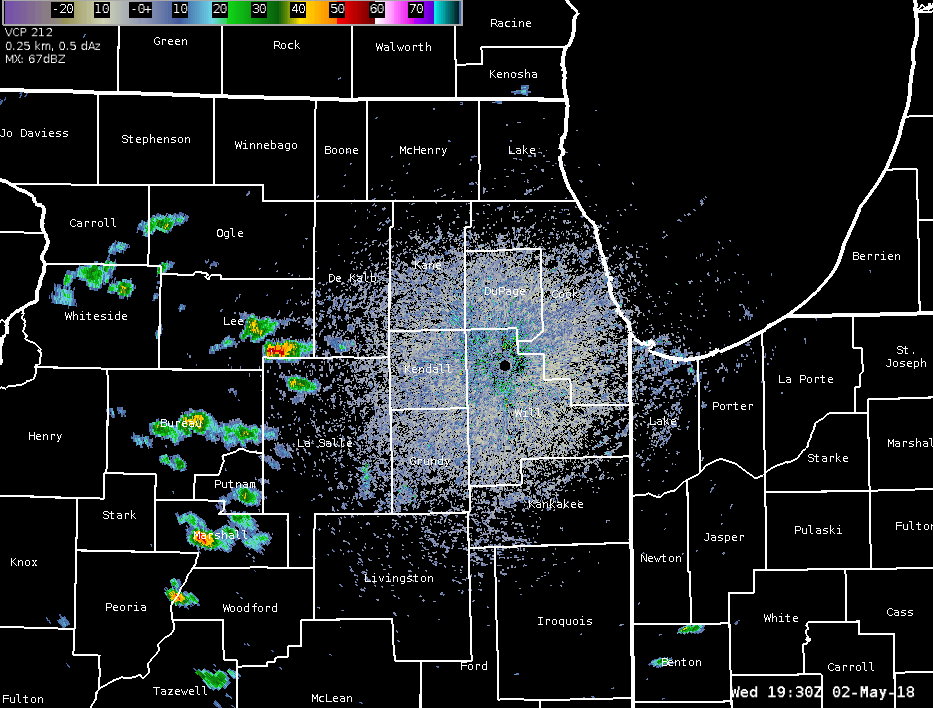
Radar:
Radar loop for 2:30-10 p.m. CDT
 |
Environment
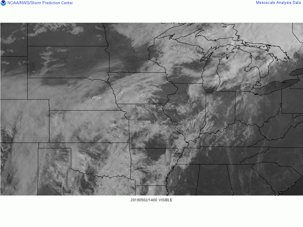
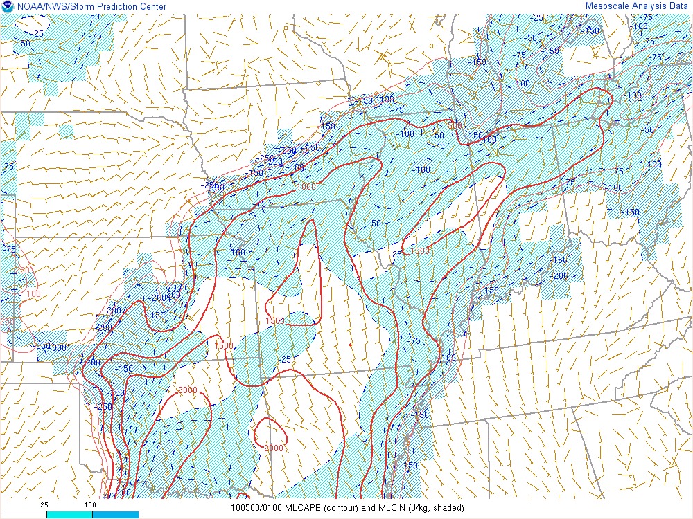
Clearing after the passage of a decaying thunderstorm complex Wednesday morning allowed for several hours of mostly sunny skies late morning into the early afternoon. Associated heating and a gradual increase of surface dew points from Gulf of America moisture allowed the the atmosphere to destabilize prior to the initialization of thunderstorms around 2pm. The cap on the environment, which initially suppressed storms, quickly eroded during the mid afternoon. This allowed storm coverage to increase as environmental shear gradually increased, setting up an environment conducive for severe convection across northern Illinois and northwest Indiana.
 |
 |
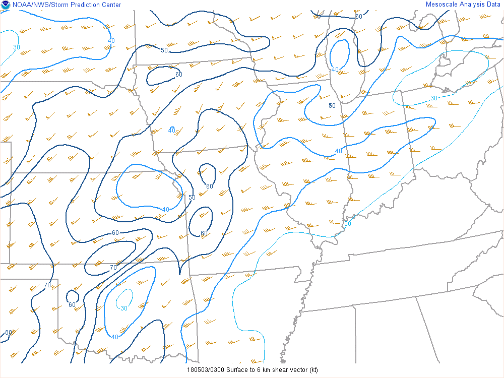 |
| Figure 1: Visible satellite showing clearing behind a decaying thunderstorm complex across central Illinois in the morning. | Figure 2: MLCAPE (red outline) and MLCIN (blue shade) showing destabilization and erosion of the cap. | Figure 3: 0-6 km shear gradually increased as storms moved across northern Illinois |
Service
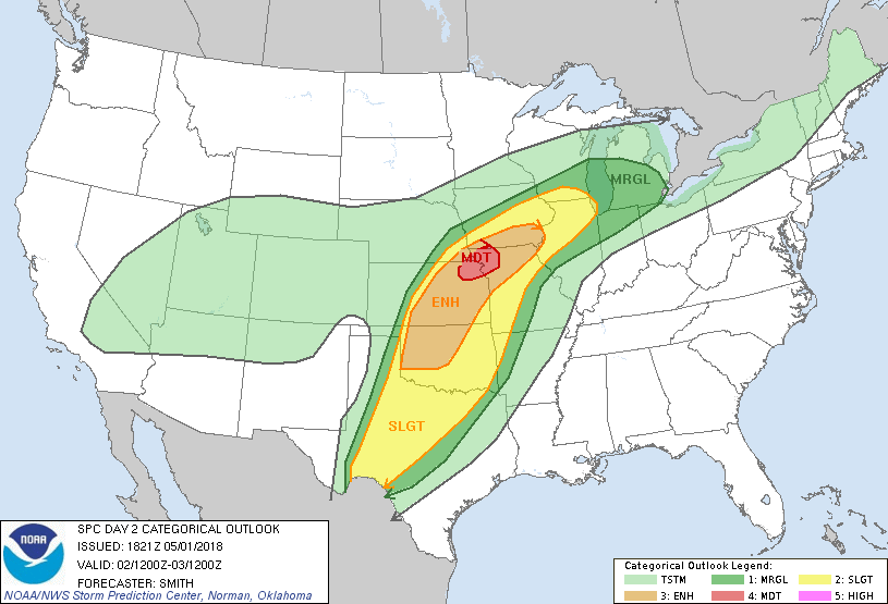
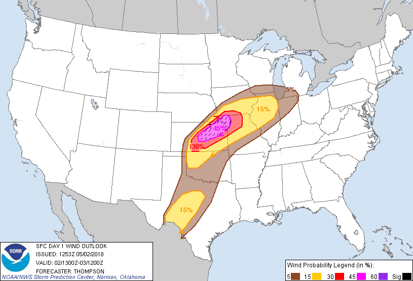
| NWS Storm Prediction Center Severe Weather Outlooks for May 2nd and Dates Issued | ||
 |
 |
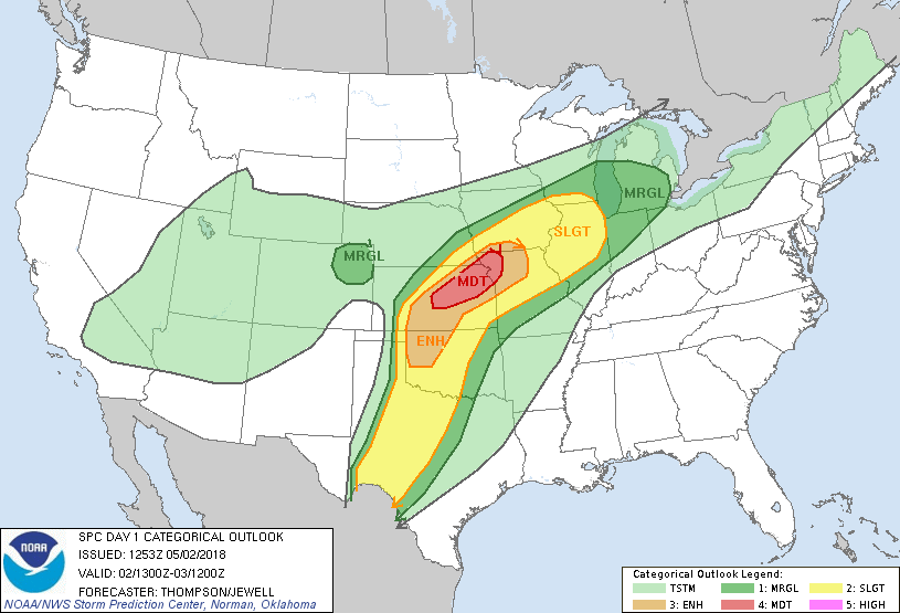 |
| April 30th | May 1st | May 2nd (8 a.m.) |
 |
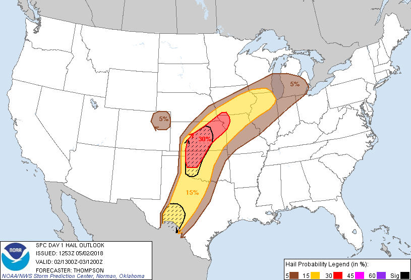 |
| May 2nd Damaging Wind Outlook (8 a.m.) | May 2nd Large Hail Outlook (8 a.m.) |
| Watches Issued | |
 |
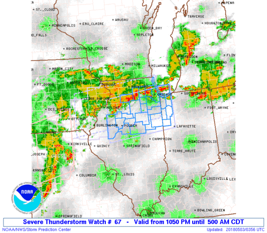 |
| Severe Thunderstorm Watch Issued at 3:55 pm | Severe Thunderstorm Watch Issued at 10:50 pm |
| NWS Chicago Issued Products and Services | |
 |
 |
| Weather Story issued May 1st | Weather Story issued May 2nd |
 |
 |
| Graphical NOWcast issued at 6:54 p.m. | Graphical NOWcast issued at 10:46 p.m. |
 |
 |
| Warning Polygons | Warnings and Storm Reports |
Storm Reports
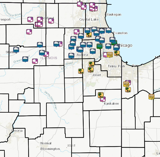
Storm report map and text for the past 24-hours: https://www.weather.gov/source/crh/lsrmap.html?zoom=8&lat=41.33&lon=-89.4&hr=24
PRELIMINARY LOCAL STORM REPORT...SUMMARY
NATIONAL WEATHER SERVICE CHICAGO/ROMEOVILLE IL
1136 PM CDT WED MAY 2 2018

..TIME...   ...EVENT...      ...CITY LOCATION...     ...LAT.LON...
..DATE...   ....MAG....      ..COUNTY LOCATION..ST.. ...SOURCE....
            ..REMARKS..

0934 PM     HAIL             LINDENHURST             42.42N 88.03W
05/02/2018  M1.00 INCH       LAKE               IL   TRAINED SPOTTER

            RELAYED VIA TWITTER.

0934 PM     HAIL             LAKE VILLA              42.42N 88.08W
05/02/2018  M2.00 INCH       LAKE               IL   PUBLIC

            RELAYED VIA TWITTER.

0933 PM     HAIL             LAKE VILLA              42.42N 88.08W
05/02/2018  M2.00 INCH       LAKE               IL   TRAINED SPOTTER

            2.25 INCH DIAMETER HAIL AT FAIRFIELD AND PETITE LAKE
            ROAD.

0932 PM     HAIL             LAKE VILLA              42.42N 88.08W
05/02/2018  M1.00 INCH       LAKE               IL   AMATEUR RADIO

0931 PM     HAIL             ANTIOCH                 42.47N 88.08W
05/02/2018  E1.50 INCH       LAKE               IL   PUBLIC

            RELAYED VIA TWITTER.

0931 PM     HAIL             LAKE VILLA              42.42N 88.08W
05/02/2018  M1.75 INCH       LAKE               IL   LAW ENFORCEMENT

            AT DEEP LAKE ROAD JUST SOUTH OF GRASS LAKE ROAD.

0928 PM     HAIL             ANTIOCH                 42.47N 88.08W
05/02/2018  M1.75 INCH       LAKE               IL   TRAINED SPOTTER

            HAIL STONES BETWEEN GOLFBALL AND EGG SIZED. NUMEROUS
            BRANCHES DOWN. DAMAGE TO SIDING AND CARS.

0928 PM     HAIL             ANTIOCH                 42.47N 88.08W
05/02/2018  M1.75 INCH       LAKE               IL   TRAINED SPOTTER

            FROM LAKE COUNTY SKYWARN. ROUTE 59 AND GRASS LAKE ROAD.

0920 PM     HAIL             SPRING GROVE            42.44N 88.24W
05/02/2018  M2.00 INCH       MCHENRY            IL   TRAINED SPOTTER

            2.25 INCH DIAMETER HAIL VIA LAKE COUNTY SKYWARN. NEAREST
            INTERSECTION WINN ROAD AND ROUTE 12.

0910 PM     HAIL             RICHMOND                42.48N 88.31W
05/02/2018  E2.75 INCH       MCHENRY            IL   PUBLIC

            2.5 TO 2.75 INCH DIAMETER HAIL RELAYED VIA FACEBOOK.

0823 PM     HAIL             2 NE CEDAR LAKE         41.39N 87.41W
05/02/2018  U1.25 INCH       LAKE               IN   PUBLIC

            VIA MPING.

0804 PM     TSTM WND GST     CEDAR LAKE              41.37N 87.44W
05/02/2018  M61.00 MPH       LAKE               IN   TRAINED SPOTTER

0718 PM     TSTM WND DMG     HOFFMAN ESTATES         42.06N 88.14W
05/02/2018                   COOK               IL   TRAINED SPOTTER

            DOWNED PINE TREE ABOUT 40 FEET TALL. ESTIMATED WINDS
            AROUIND 65 MPH.

0706 PM     HAIL             GILBERTS                42.10N 88.37W
05/02/2018  E1.50 INCH       KANE               IL   PUBLIC

            RELAYED VIA TWITTER.

0640 PM     HAIL             CORTLAND                41.93N 88.69W
05/02/2018  M0.50 INCH       DE KALB            IL   TRAINED SPOTTER

0640 PM     HAIL             S DE KALB               41.93N 88.75W
05/02/2018  M1.00 INCH       DE KALB            IL   TRAINED SPOTTER

            MILNER AVE AND SOUTH 1ST STREET. QUARTER SIZED HAIL
            COVERING THE GROUND. TIME ESTIMATED.

0635 PM     HAIL             DE KALB                 41.93N 88.75W
05/02/2018  M1.00 INCH       DE KALB            IL   PUBLIC

0632 PM     HAIL             2 S BYRON               42.10N 89.26W
05/02/2018  M1.00 INCH       OGLE               IL   EMERGENCY MNGR

0623 PM     HAIL             BELVIDERE               42.25N 88.85W
05/02/2018  M1.25 INCH       BOONE              IL   AMATEUR RADIO

            RELAYED VIA RFD HAM NET

0620 PM     TSTM WND GST     3 S DUNNS BRIDGE        41.19N 86.97W
05/02/2018  M61.00 MPH       JASPER             IN   TRAINED SPOTTER

            MEASURED VIA MOBILE WEATHER STATION AT SR 10 AND CR 400E
            IN JASPER COUNTY.

0616 PM     HAIL             LEE                     41.79N 88.94W
05/02/2018  E1.75 INCH       DE KALB            IL   PUBLIC

            SOCIAL MEDIA REPORT

0614 PM     HAIL             SE ROCKFORD             42.27N 89.06W
05/02/2018  M3.00 INCH       WINNEBAGO          IL   PUBLIC

            DELAYED REPORT VIA TWITTER FROM FAR SOUTHEAST ROCKFORD.

0614 PM     HAIL             ROCKFORD                42.27N 89.06W
05/02/2018  M2.50 INCH       WINNEBAGO          IL   PUBLIC

            MULTIPLE SOCIAL MEDIA REPORTS OF 2.5 INCH DIAMATER HAIL
            IN FAR SE ROCKFORD

0610 PM     HAIL             2 E ROCKFORD AIRPORT    42.20N 89.06W
05/02/2018  E1.50 INCH       WINNEBAGO          IL   AMATEUR RADIO

0607 PM     HAIL             ROCKFORD AIRPORT        42.20N 89.10W
05/02/2018  M2.00 INCH       WINNEBAGO          IL   AMATEUR RADIO

            REPORT RELAYED BY ROCKFORD HAM NET

0605 PM     HAIL             5 SSW ROCKFORD          42.20N 89.09W
05/02/2018  M1.75 INCH       WINNEBAGO          IL   TRAINED SPOTTER

            MULTIPLE REPORTS OF GOLF BALL SIZED HAIL AROUND THE
            ROCKFORD AIRPORT.

0600 PM     HAIL             WEST BROOKLYN           41.69N 89.15W
05/02/2018  M1.00 INCH       LEE                IL   TRAINED SPOTTER

            MAINLY DIME TO NICKEL SIZE HAIL, BUT ONE QUARTER SIZE
            STONE.

0554 PM     HAIL             WINNEBAGO               42.27N 89.24W
05/02/2018  M1.00 INCH       WINNEBAGO          IL   TRAINED SPOTTER

            PENNY TO QUARTER SIZE HAIL ON THE SOUTHWEST SIDE OF
            WINNEBAGO

0546 PM     TSTM WND DMG     LOWELL                  41.29N 87.41W
05/02/2018                   LAKE               IN   BROADCAST MEDIA

            MULTIPLE TREES OF UNKNOWN SIZE SNAPPED, POWER POLE
            SNAPPED, AND TRAILER FLIPPED ON US 41 IN LOWELL. TIME
            ESTIMATED.

0515 PM     HAIL             BOURBONNAIS             41.16N 87.88W
05/02/2018  M1.00 INCH       KANKAKEE           IL   TRAINED SPOTTER

            QUARTER SIZE HAIL AND 60 MPH WIND GUSTS.

0510 PM     TSTM WND DMG     4 NW BOURBONNAIS        41.21N 87.92W
05/02/2018                   KANKAKEE           IL   EMERGENCY MNGR

            20 POWER POLES DOWNED AND SEVERAL ROOFS PULLED BACK.

0510 PM     TSTM WND DMG     4 NNW BOURBONNAIS       41.22N 87.92W
05/02/2018                   KANKAKEE           IL   TRAINED SPOTTER

            18 POWER POLES DOWNED...ALONG WITH A CORN CRIB AND METAL
            SILOS IN A DEBRIS FIELD ORIENTED ROUGHLY TOWARD EAST.
            LOCATION A QUARTER MILE SOUTH OF 6731N 2250W.

0503 PM     TSTM WND DMG     CHICAGO                 41.88N 87.63W
05/02/2018                   COOK               IL   EMERGENCY MNGR

            CHICAGO OEMC REPORTS NUMEROUS TREES DOWN AND AN APARTMENT
            BUILDING ROOF PEELED BACK. DAMAGE IS EAST OF THE DAN
            RYAN/I-94 POSSIBLY TO THE LAKE AND BETWEEN 63RD AND 39TH
            STREETS. DELAYED REPORT AND TIME ESTIMATED FROM RADAR.

0500 PM     TSTM WND DMG     5 N CHATHAM             41.80N 87.62W
05/02/2018                   COOK               IL   FIRE DEPT/RESCUE

            ROOF DAMAGE TO A BUILDING ACROSS FROM WASHINGTON PARK AT
            51ST AND KING DRIVE...5035 KING DRIVE. ALSO DOWNED TREES
            IN THE AREA. DAMAGE RESULTED IN AN EVACUATION ORDER BY
            CFD AND DEPT OF BUILDINGS. TIME ESTIMATED BY RADAR.

0453 PM     HAIL             MIDWAY AIRPORT          41.78N 87.75W
05/02/2018  E1.00 INCH       COOK               IL   PUBLIC

            REPORTED BY SOUTHWEST AIRLINES EMPLOYEE.

0452 PM     TSTM WND DMG     MIDWAY AIRPORT          41.78N 87.75W
05/02/2018                   COOK               IL   PUBLIC

            MULTIPLE REPORTS OF DAMANGE FROM STRONG WINDS AND QUARTER
            SIZE HAIL NEAR MIDWAY AIRPORT. DAMAGE TO TREES, VEHICLES,
            LIGHT POLES, AND HOUSES INCLUDING SIDING AND A LARGE
            SECTION OF ROOF TORN OFF.

0451 PM     TSTM WND GST     MIDWAY AIRPORT          41.78N 87.75W
05/02/2018  M67.00 MPH       COOK               IL   ASOS

            58 KNOT GUST.

0446 PM     HAIL             SUMMIT                  41.78N 87.82W
05/02/2018  E1.00 INCH       COOK               IL   PUBLIC

            REPORT VIA TWITTER

0445 PM     TSTM WND DMG     CREST HILL              41.57N 88.11W
05/02/2018                   WILL               IL   TRAINED SPOTTER

            MULTIPLE TREE LIMBS OF 2-6 INCHES IN DIAMETER DOWN AND
            ONE EVERGREEN TREE 15-20 INCHES IN DIAMETER UPROOTED

0445 PM     TSTM WND DMG     ROMEOVILLE              41.65N 88.09W
05/02/2018                   WILL               IL   EMERGENCY MNGR

            SEVERAL TELEPHONE POLES SNAPPED IN HALF ON RENWICK ROAD

0445 PM     TSTM WND DMG     CREST HILL              41.57N 88.11W
05/02/2018                   WILL               IL   TRAINED SPOTTER

            A COUPLE TREE LIMBS TWO INCHES IN DIAMETER DOWN AND PEA
            SIZE HAIL

0430 PM     TSTM WND DMG     6 SW PLAINFIELD         41.55N 88.29W
05/02/2018                   KENDALL            IL   NWS EMPLOYEE

            LARGE TREE BRANCH BROKEN. REPORTED BY OFF DUTY NWS
            EMPLOYEE. TIME ESTIMATED.
Additional Information
 |
Media use of NWS Web News Stories is encouraged! Please acknowledge the NWS as the source of any news information accessed from this site. |
|

