Louisville, KY
Weather Forecast Office
Have you ever wondered why frost can form on nights when the temperatures only fall to 36 or 37 degrees? The Kentucky Mesonet recently added some extra temperature sensors at varying heights that show just why this could occur. The plot below shows a 24-hour trace of the temperature measured at 0.5 meters above the ground (in blue), at 2 meters above the ground (in red), and at 3 meters above ground (in orange). An official temperature reading is taken in a special instrument shelter that shades from the direct sunlight as well as provides ventilation AND is situated at 2 meters above the ground level. So the readings you see at Standiford Field (aka, the Louisville Airport) as well as at Bluegrass Airport in Lexington are taken at 2 meters above the ground.
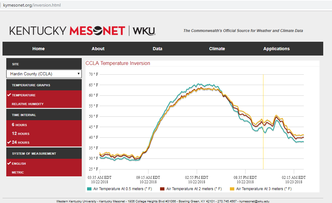
Notice on the right side of the image above, the readings taken at night are cooler closer to the ground. The difference between the 0.5- and 2-meter temperatures in this plot are on the order of 3-5 degrees at night! On a clear and calm night, the temperature close to the ground easily can be 5 or more degrees cooler than at the standard height. Thus you sometimes will see a forecast of frost even with lows in the upper 30s. This property of warmer air above the surface is night is called an "inversion", as it is typical to see temperatures drop as you go aloft during the day (see the daytime readings in the plot above).
Current Hazards
Hazardous Weather Outlook
Storm Prediction Center
Submit a Storm Report
Advisory/Warning Criteria
Radar
Fort Knox
Evansville
Fort Campbell
Nashville
Jackson
Wilmington
Latest Forecasts
El Nino and La Nina
Climate Prediction
Central U.S. Weather Stories
1-Stop Winter Forecast
Aviation
IDSS Forecast Points
Air Quality
Fire Weather
Recreation Forecasts
1-Stop Drought
Event Ready
1-Stop Severe Forecast
Past Weather
Climate Graphs
1-Stop Climate
CoCoRaHS
Local Climate Pages
Tornado History
Past Derby/Oaks/Thunder Weather
Football Weather
Local Information
About the NWS
Forecast Discussion
Items of Interest
Spotter Training
Regional Weather Map
Decision Support Page
Text Products
Science and Technology
Outreach
LMK Warning Area
About Our Office
Station History
Hazardous Weather Outlook
Local Climate Page
Tornado Machine Plans
Weather Enterprise Resources
US Dept of Commerce
National Oceanic and Atmospheric Administration
National Weather Service
Louisville, KY
6201 Theiler Lane
Louisville, KY 40229-1476
502-969-8842
Comments? Questions? Please Contact Us.


 Weather Story
 Weather Map
 Local Radar