Louisville, KY
Weather Forecast Office
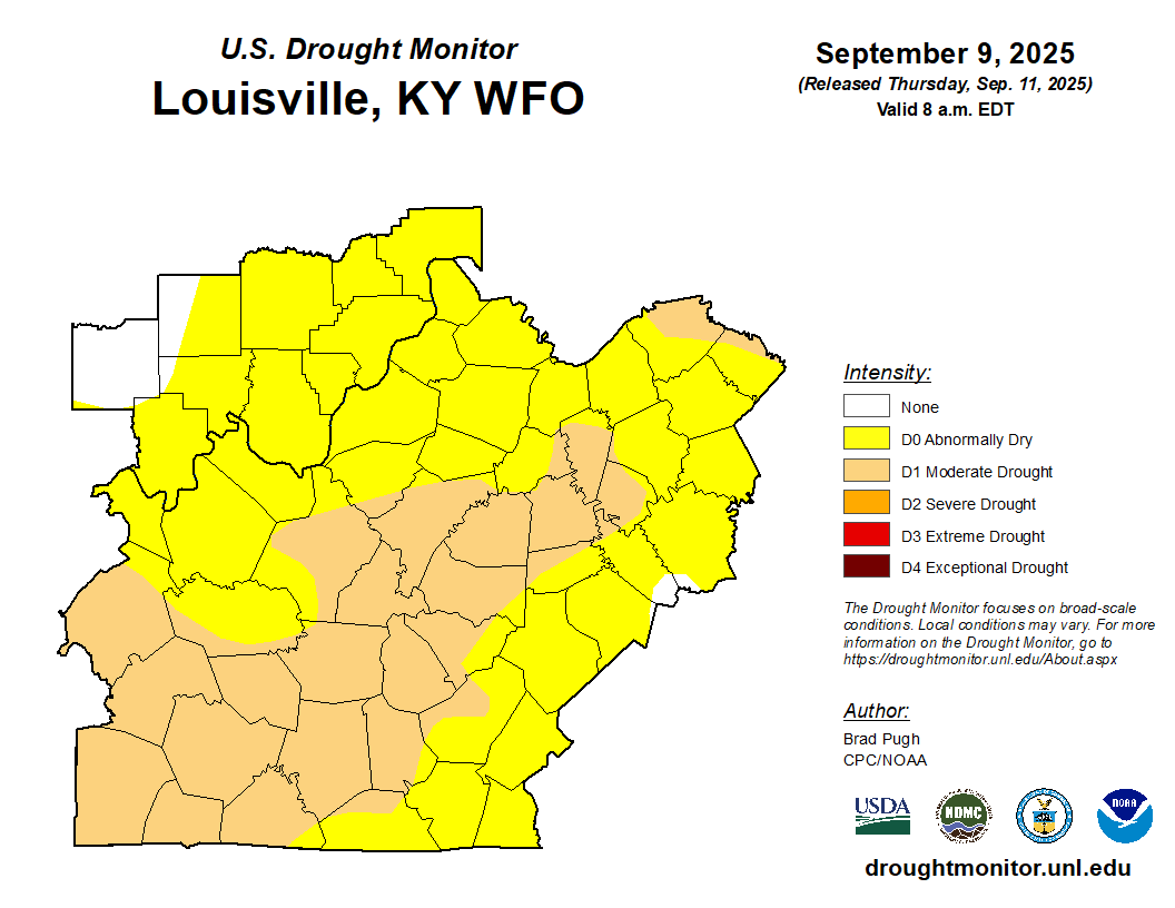
While portions of Kentucky and Indiana received beneficial rainfall during the second half of last week, mainly dry weather across the region since last weekend has contributed to the persistence of abnormally dry and drought conditions across most of the region.
Here are updated slides with the latest drought information for southern Indiana and central Kentucky:
Drought Update September 11th, 2025
Here are some key points from this week's Drought Monitor update:
Severe Drought (D2) was introduced in SW KY.
Moderate Drought (D1) was expanded across western KY while reduced across portions of central and eastern KY. Abnormally Dry (D0) conditions were also reduced across portions of eastern KY.
Minor changes to Indiana this week with an addition of Moderate Drought (D1) across a portion of east central IN.
Drought conditions are likely to worsen as above normal temperatures and little to no rainfall are expected over the next week.
For more information, go to the U.S. Drought Monitor.
Current Hazards
Hazardous Weather Outlook
Storm Prediction Center
Submit a Storm Report
Advisory/Warning Criteria
Radar
Fort Knox
Evansville
Fort Campbell
Nashville
Jackson
Wilmington
Latest Forecasts
El Nino and La Nina
Climate Prediction
Central U.S. Weather Stories
1-Stop Winter Forecast
Aviation
IDSS Forecast Points
Air Quality
Fire Weather
Recreation Forecasts
1-Stop Drought
Event Ready
1-Stop Severe Forecast
Past Weather
Climate Graphs
1-Stop Climate
CoCoRaHS
Local Climate Pages
Tornado History
Past Derby/Oaks/Thunder Weather
Football Weather
Local Information
About the NWS
Forecast Discussion
Items of Interest
Spotter Training
Regional Weather Map
Decision Support Page
Text Products
Science and Technology
Outreach
LMK Warning Area
About Our Office
Station History
Hazardous Weather Outlook
Local Climate Page
Tornado Machine Plans
Weather Enterprise Resources
US Dept of Commerce
National Oceanic and Atmospheric Administration
National Weather Service
Louisville, KY
6201 Theiler Lane
Louisville, KY 40229-1476
502-969-8842
Comments? Questions? Please Contact Us.


 Weather Story
 Weather Map
 Local Radar