October 2019 Precipitation Highlights:
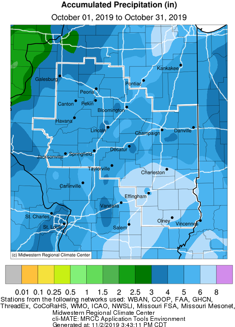
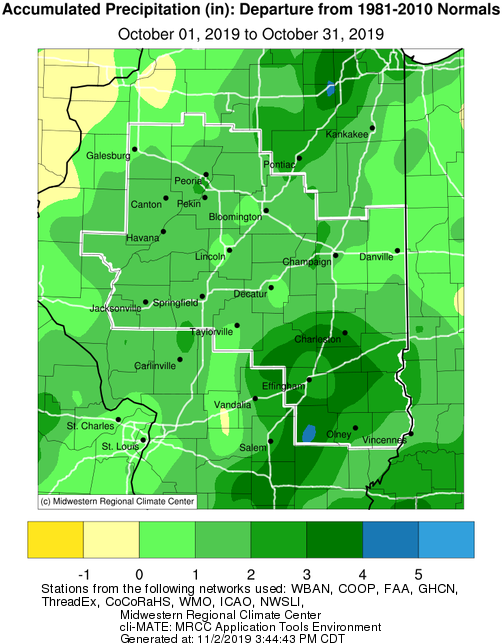
- The first 25 days of October were pretty dry and favored harvest conditions in central and southeast IL. Much of central IL only had 1 to 2 inches of rain during the first 3.5 weeks of the month. Then the remnants of tropical storm Olga came up from the western Gulf of America into east central Illinois by sunset Saturday evening Oct 26th bringing a widespread 1-3 inch rain, with the heaviest amounts in the heart of central IL along I-55. Another 1-2 inch rain fall over much of central IL from Oct 28-31st with much of central and southeast IL having 4 to 6 inches of precipitation during October, with Flora having 8.3 inches of rain! Thus the colder and very wet weather pattern during the last week of October delayed harvest activities. Aside from some minor wind damage in Pana in southeast Christian county around sunrise on Oct 10th, there was no severe weather over central and southeast IL during October.
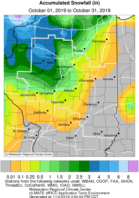
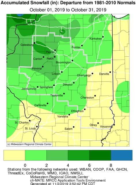
- The much colder weather at end of the month brought an early season snowfall to central IL on Halloween with 1-5 inches of snow falling over areas west of I-57. Peoria had 3.9 inches of snow on Oct 31st making it the snowiest day in October, while the 4.2 inch snow during the month made it the snowiest October on record! Springfield's 2.3 inch snow and Lincoln's 2 inch snow on Oct 31st made it their snowiest Halloween on record.
Review of Halloween 2019 Snow Event
 |
 |
October 2019 Temperature Highlights:
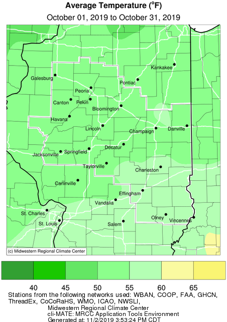
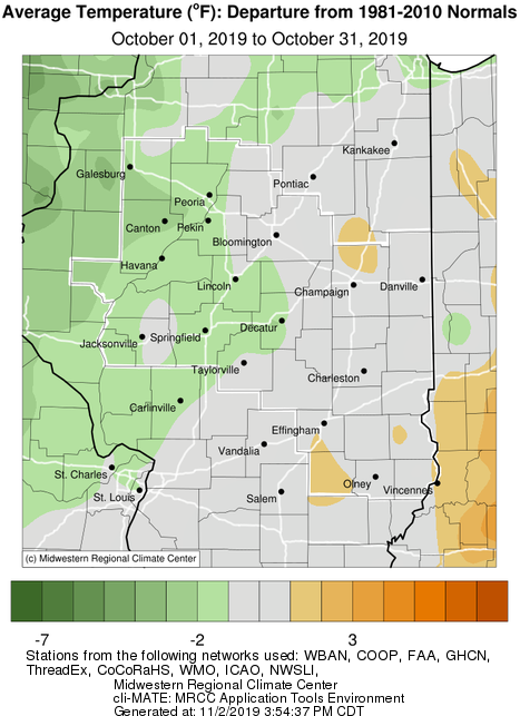
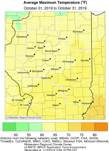
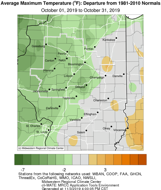
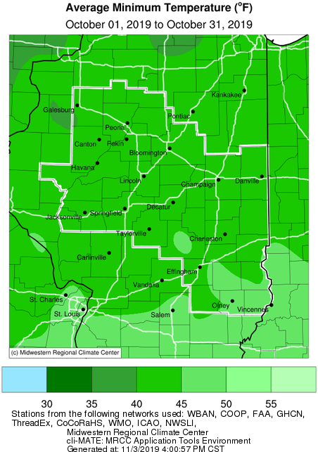
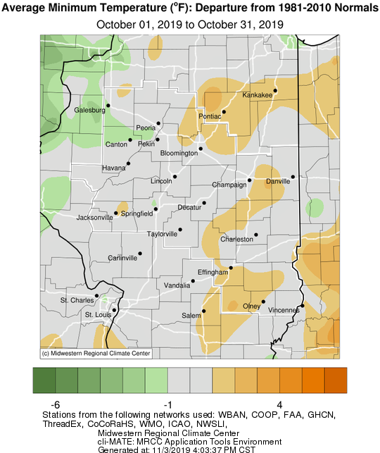
- Temperatures were 1-2 degrees below normal over areas west of I-57 during October, while eastern IL was closer to normal or even 1-2 degrees above normal in southeast Illinois. Hot and humid summerlike weather started the month with highs in the upper 80s to mid 90s from Oct 1-2 with muggy lows in the upper 60s and lower 70s. The 1st freeze of the fall season occurred early Saturday morning Oct 12th over much of central IL with lows in the lower 30s along and north of I-72. Frost continued to affect parts of central and southeast IL from the mornings of Oct 12-18th. It was a very cold and brisk Halloween with a few inches of snow from I-55 northwest and highs only in the low to mid 30s with some cities setting their coolest highs on record on Oct 31st. Some cities delayed their trick-or-treating due to the inclement weather on Halloween. A hard freeze occurred over Illinois on Halloween night with lows in the low to mid 20s over central IL, and upper 20s in southeast IL effectively ending the growing season across Illinois. Peoria tied a record low of 21 degrees on early Friday morning Nov 1st.
 |
 |
October Climate Statistics:
|
City
|
Precipitation
|
Departure from Normal |
Snow |
Departure
from
Normal
|
Average Temperature
|
Departure from Normal |
|
Charleston
|
6.08" |
+2.32" |
0.2" |
+0.2" |
55.3 |
-1.0 |
| Danville |
4.66"
|
+1.09" |
NA |
NA |
54.5 |
-0.5 |
|
Decatur
|
4.99" |
+1.74" |
1.0" |
+1.0" |
53.9 |
-2.3 |
| Effingham |
6.20" |
+2.61" |
0.0" |
0.0" |
56.5 |
+1.2
|
|
Flora
|
8.30" |
+4.63" |
NA |
NA |
56.9 |
+1.6 |
|
Galesburg
|
3.37" |
+0.62" |
3.0" |
+3.0" |
50.1 |
-2.4 |
|
Havana
|
4.93" |
+1.89" |
1.2" |
+1.2" |
NA |
NA |
|
Jacksonville
|
3.96" |
+0.95" |
0.2" |
+0.2" |
54.7 |
+0.5 |
|
Lincoln
|
4.74" |
+1.66" |
2.0" |
+2.0" |
52.8 |
-1.0 |
|
Normal
|
5.43"
|
+2.15 |
3.2" |
+3.1" |
52.9 |
-0.2 |
|
Olney
|
5.96" |
+1.97" |
0.0" |
0.0" |
56.9 |
+0.7 |
|
Paris
|
4.55" |
+1.17" |
0.0" |
-0.1" |
54.5 |
-0.3 |
|
Peoria
|
5.30" |
+2.46" |
4.2" |
+4.2" |
52.0 |
-2.0 |
| Springfield |
4.66"
|
+1.51" |
2.3" |
+2.3" |
53.3 |
-1.8 |
|
Taylorville
|
4.51" |
+0.96" |
NA |
NA |
NA |
NA |
|
Tuscola
|
4.17" |
+0.92" |
0.0" |
0.0" |
54.9 |
+0.4 |
|
Urbana
|
5.00" |
+1.74" |
0.0" |
-0.1" |
53.7 |
-0.2 |
The following links are the monthly climate summaries for area cities. Only the summaries for Peoria, Springfield, and Lincoln are considered "official", meaning they are the station of record for their respective locations. The other summaries are "supplemental", meaning another location in the area is the official climate station for the city.
- Peoria -- Peoria International Airport
- Springfield -- Abraham Lincoln Capital Airport
- Lincoln -- National Weather Service Office
- Champaign -- University of Illinois-Willard Airport
- Decatur -- Decatur Airport
- Lawrenceville -- Lawrenceville-Vincennes International Airport
- Mattoon -- Coles County Memorial Airport
Climate data for other cities is available at http://w2.weather.gov/climate/xmacis.php?wfo=ilx
