Overview
|
A line of severe thunderstorms pushed across portions of central Illinois mainly north of I-72 during the morning of Wednesday, June 17th. A remnant outflow boundary from morning storms / effective warm front set up near and between the I-72 and I-70 corridors Wednesday afternoon and evening and served as the focus for intense thunderstorms later in the day. Several tornadoes were reported along with widespread damaging wind gusts up to around 80 mph, wind-driven hail as large as 3 inches in diameter, and localized flash flooding. |
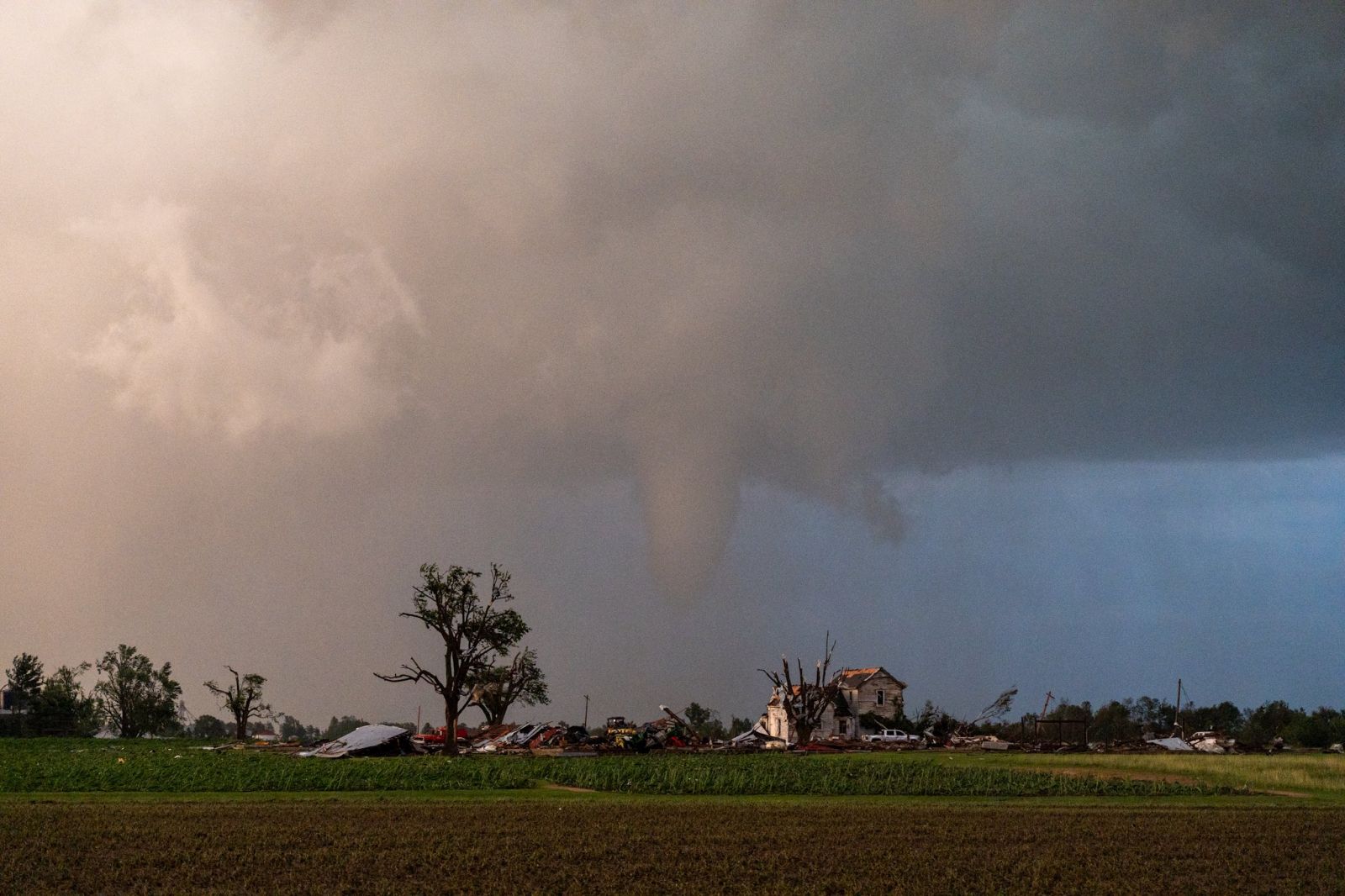 Tornado near Effingham, IL (Photo: Jakob McMillin) |
Tornadoes
Select a tornado from the table to zoom into the track and view more information. The default table view is limited to 8 tracks, but can be scrolled by a mouse wheel or dynamically expanded. Additionally, the table can fill the entire window by clicking the small circular expanding arrow icon at the very top right of the table and returned to its original size by clicking the button again. The side information panel that opens over the map can be closed using the "X" on the upper right corner of the pop-up. Zoom into the map and click damage points to see detailed information and pictures from the surveys.
|
NOTE: times shown below are local to your device's time zone. |

The Enhanced Fujita (EF) Scale classifies tornadoes into the following categories:
| EF0 Weak 65-85 mph |
EF1 Moderate 86-110 mph |
EF2 Significant 111-135 mph |
EF3 Severe 136-165 mph |
EF4 Extreme 166-200 mph |
EF5 Catastrophic 200+ mph |
 |
|||||
| Tornadoes that fail to impact any ratable damage indicators on the EF-Scale are rated EF-Unknown (EF-U) | |||||
Storm Reports
Preliminary Local Storm Report...Summary National Weather Service Lincoln IL 1057 AM CDT Thu Jun 18 2026 ..TIME... ...EVENT... ...CITY LOCATION... ...LAT.LON... ..DATE... ....MAG.... ..COUNTY LOCATION..ST.. ...SOURCE.... ..REMARKS.. 1028 AM Tstm Wnd Dmg Chenoa 40.74N 88.72W 06/17/2026 McLean IL Emergency Mngr Semi rollover reported near the city of Chenoa. 1120 AM Rain Rushville 40.12N 90.56W 06/17/2026 M1.24 Inch Schuyler IL Emergency Mngr 3 hour rainfall total. 1245 PM Rain 1 SW Havana 40.29N 90.07W 06/17/2026 M1.33 Inch Mason IL Mesonet Mesonet station HAVI2 0.7 W Havana. 1245 PM Rain 1 WSW London Mills 40.71N 90.28W 06/17/2026 M1.40 Inch Fulton IL Mesonet Mesonet station LNMI2 0.7 W London Mills. 0100 PM Rain 2 E Bloomington 40.48N 88.96W 06/17/2026 M1.20 Inch McLean IL NWS Employee Rainfall since 10 am and still raining at 1 pm. 0100 PM Rain Havana 40.30N 90.06W 06/17/2026 M1.70 Inch Mason IL Public 0111 PM Rain 2 NNW Washington 40.74N 89.42W 06/17/2026 M1.61 Inch Tazewell IL Mesonet Mesonet station EW4888 Washington. 0111 PM Rain Washington 40.70N 89.42W 06/17/2026 M1.58 Inch Tazewell IL Mesonet Mesonet station EW8799 Washington. 0111 PM Rain 3 ENE East Peoria 40.69N 89.53W 06/17/2026 M1.55 Inch Tazewell IL Mesonet Mesonet station EW6160 East Peoria. 0114 PM Rain 1 NNE Peoria Intl Airpo 40.67N 89.68W 06/17/2026 M1.25 Inch Peoria IL ASOS ASOS station KPIA Peoria Intl Arpt. 0115 PM Rain 1 SSW Germantown Hills 40.76N 89.48W 06/17/2026 M1.91 Inch Woodford IL Mesonet Mesonet station AX391 GERMANTOWN HILLS. 0115 PM Rain 2 NW Metamora 40.81N 89.38W 06/17/2026 M1.68 Inch Woodford IL Mesonet Mesonet station AU804 1 NW Metamora. 0115 PM Rain 3 N Panola 40.82N 89.02W 06/17/2026 M1.24 Inch Woodford IL Mesonet Mesonet station 8089D 2 N Panola. 0115 PM Rain Pekin 40.57N 89.63W 06/17/2026 M1.94 Inch Tazewell IL Mesonet Mesonet station FW0283 Pekin. 0115 PM Rain 1 NW Washington 40.71N 89.42W 06/17/2026 M1.54 Inch Tazewell IL Mesonet Mesonet station FW7110 Washington. 0115 PM Rain 1 S Goodfield 40.61N 89.28W 06/17/2026 M1.22 Inch Tazewell IL Mesonet Mesonet station DW8284 Goodfield. 0115 PM Rain 2 WNW Browning 40.14N 90.42W 06/17/2026 M1.03 Inch Schuyler IL Mesonet Mesonet station DW9440 Browning. 0115 PM Rain Galesburg Airport 40.93N 90.43W 06/17/2026 M1.39 Inch Knox IL AWOS AWOS station KGBG Galesburg Arpt. 0115 PM Rain Avon 40.66N 90.44W 06/17/2026 M2.30 Inch Fulton IL Emergency Mngr Rainfall so far today. 0115 PM Rain 5 ENE Waynesville 40.26N 89.04W 06/17/2026 M1.07 Inch De Witt IL Mesonet Mesonet station DW9761 Waynesville. 0116 PM Rain 4 NE East Peoria 40.70N 89.52W 06/17/2026 M2.06 Inch Tazewell IL Mesonet Mesonet station GW3458 East Peoria. 0116 PM Rain 2 ESE Bloomington 40.47N 88.96W 06/17/2026 M1.12 Inch McLean IL Mesonet Mesonet station GW0991 Bloomington. 0116 PM Rain 2 WSW Henry 41.10N 89.40W 06/17/2026 M1.60 Inch Marshall IL Mesonet Mesonet station CW9319 Henry. 0116 PM Rain Lewistown 40.40N 90.16W 06/17/2026 M1.58 Inch Fulton IL Mesonet Mesonet station GW1851 Lewistown. 0117 PM Rain 3 E South Pekin 40.49N 89.60W 06/17/2026 M1.23 Inch Tazewell IL Mesonet Mesonet station FW1256 Pekin. 0120 PM Rain 1 NNW Morton 40.63N 89.48W 06/17/2026 M1.07 Inch Tazewell IL Mesonet Mesonet station MRTNV 1 NNW Morton. 0120 PM Rain 1 NNW Galesburg 40.96N 90.37W 06/17/2026 M1.22 Inch Knox IL Mesonet Mesonet station DW8259 Galesburg. 0121 PM Rain 3 ENE East Peoria 40.69N 89.53W 06/17/2026 M2.09 Inch Tazewell IL Mesonet Mesonet station EW6160 East Peoria. 0121 PM Rain Washington 40.70N 89.42W 06/17/2026 M1.90 Inch Tazewell IL Mesonet Mesonet station EW8799 Washington. 0121 PM Rain 2 NNW Washington 40.74N 89.42W 06/17/2026 M1.72 Inch Tazewell IL Mesonet Mesonet station EW4888 Washington. 0125 PM Rain 2 NW Metamora 40.81N 89.38W 06/17/2026 M1.85 Inch Woodford IL Mesonet Mesonet station AU804 1 NW Metamora. 0125 PM Rain 1 S Goodfield 40.61N 89.28W 06/17/2026 M1.24 Inch Tazewell IL Mesonet Mesonet station DW8284 Goodfield. 0126 PM Rain 2 WSW Henry 41.10N 89.40W 06/17/2026 M1.62 Inch Marshall IL Mesonet Mesonet station CW9319 Henry. 0126 PM Rain Lewistown 40.40N 90.16W 06/17/2026 M1.58 Inch Fulton IL Mesonet Mesonet station GW1851 Lewistown. 0127 PM Rain 4 NE East Peoria 40.70N 89.52W 06/17/2026 M2.51 Inch Tazewell IL Mesonet Mesonet station GW3458 East Peoria. 0130 PM Rain 1 SE West Peoria 40.69N 89.62W 06/17/2026 M3.39 Inch Peoria IL Mesonet Mesonet station AW321 PEORIA. 0135 PM Rain 3 N Panola 40.82N 89.02W 06/17/2026 M1.42 Inch Woodford IL Mesonet Mesonet station 8089D 2 N Panola. 0140 PM Rain 1 NNW Morton 40.63N 89.48W 06/17/2026 M1.23 Inch Tazewell IL Mesonet Mesonet station MRTNV 1 NNW Morton. 0145 PM Rain 1 WSW London Mills 40.71N 90.28W 06/17/2026 M1.41 Inch Fulton IL Mesonet Mesonet station LNMI2 0.7 W London Mills. 0200 PM Rain Astoria 40.23N 90.36W 06/17/2026 M1.98 Inch Fulton IL Mesonet Rainfall so far today. 0230 PM Rain 1 SSW Germantown Hills 40.76N 89.48W 06/17/2026 M2.26 Inch Woodford IL Mesonet Mesonet station AX391 GERMANTOWN HILLS. 0230 PM Rain 1 NW Washington 40.71N 89.42W 06/17/2026 M2.49 Inch Tazewell IL Mesonet Mesonet station FW7110 Washington. 0230 PM Rain Pekin 40.57N 89.63W 06/17/2026 M2.06 Inch Tazewell IL Mesonet Mesonet station FW0283 Pekin. 0230 PM Rain 5 ENE Waynesville 40.26N 89.04W 06/17/2026 M1.22 Inch De Witt IL Mesonet Mesonet station DW9761 Waynesville. 0231 PM Rain 3 ENE East Peoria 40.69N 89.53W 06/17/2026 M2.98 Inch Tazewell IL Mesonet Mesonet station EW6160 East Peoria. 0231 PM Rain Washington 40.70N 89.42W 06/17/2026 M2.88 Inch Tazewell IL Mesonet Mesonet station EW8799 Washington. 0231 PM Rain 2 NNW Washington 40.74N 89.42W 06/17/2026 M2.19 Inch Tazewell IL Mesonet Mesonet station EW4888 Washington. 0234 PM Rain 1 NNE Peoria Intl Airpo 40.67N 89.68W 06/17/2026 M1.76 Inch Peoria IL ASOS ASOS station KPIA Peoria Intl Arpt. 0235 PM Rain 2 NW Metamora 40.81N 89.38W 06/17/2026 M2.23 Inch Woodford IL Mesonet Mesonet station AU804 1 NW Metamora. 0235 PM Rain 1 S Goodfield 40.61N 89.28W 06/17/2026 M1.98 Inch Tazewell IL Mesonet Mesonet station DW8284 Goodfield. 0235 PM Rain Galesburg Airport 40.93N 90.43W 06/17/2026 M1.06 Inch Knox IL AWOS AWOS station KGBG Galesburg Arpt. 0236 PM Rain 2 WSW Henry 41.10N 89.40W 06/17/2026 M2.02 Inch Marshall IL Mesonet Mesonet station CW9319 Henry. 0237 PM Rain Lewistown 40.40N 90.16W 06/17/2026 M1.84 Inch Fulton IL Mesonet Mesonet station GW1851 Lewistown. 0239 PM Rain 1 SE West Peoria 40.69N 89.62W 06/17/2026 M4.37 Inch Peoria IL Mesonet Mesonet station AW321 PEORIA. 0240 PM Rain 3 N Panola 40.82N 89.02W 06/17/2026 M1.76 Inch Woodford IL Mesonet Mesonet station 8089D 2 N Panola. 0240 PM Rain 1 NNW Galesburg 40.96N 90.37W 06/17/2026 M1.52 Inch Knox IL Mesonet Mesonet station DW8259 Galesburg. 0245 PM Rain 1 NNW Morton 40.63N 89.48W 06/17/2026 M1.61 Inch Tazewell IL Mesonet Mesonet station MRTNV 1 NNW Morton. 0245 PM Rain 1 SW Havana 40.29N 90.07W 06/17/2026 M1.36 Inch Mason IL Mesonet Mesonet station HAVI2 0.7 W Havana. 0257 PM Hail Dunlap 40.86N 89.68W 06/17/2026 M1.00 Inch Peoria IL Emergency Mngr Quarter size hail. 0300 PM Rain 5 ENE Waynesville 40.26N 89.04W 06/17/2026 M1.30 Inch De Witt IL Mesonet Mesonet station DW9761 Waynesville. 0308 PM Tstm Wnd Dmg Germantown Hills 40.77N 89.47W 06/17/2026 Woodford IL Broadcast Media Large tree blown down over road at 1419 Hickory Point in Germantown Hills. 0308 PM Hail 2 W Emden 40.30N 89.52W 06/17/2026 M0.88 Inch Logan IL Broadcast Media Nickel size hail west of Emden. 0311 PM Rain Washington 40.70N 89.42W 06/17/2026 M2.95 Inch Tazewell IL Mesonet Mesonet station EW8799 Washington. 0313 PM Hail Metamora 40.79N 89.36W 06/17/2026 M1.00 Inch Woodford IL Public Quarter size hail. 0315 PM Rain 2 NW Metamora 40.81N 89.38W 06/17/2026 M2.49 Inch Woodford IL Mesonet Mesonet station AU804 1 NW Metamora. 0315 PM Rain 1 SSW Germantown Hills 40.76N 89.48W 06/17/2026 M2.31 Inch Woodford IL Mesonet Mesonet station AX391 GERMANTOWN HILLS. 0315 PM Rain 3 N Panola 40.82N 89.02W 06/17/2026 M1.76 Inch Woodford IL Mesonet Mesonet station 8089D 2 N Panola. 0315 PM Rain 4 E Royal 40.19N 87.89W 06/17/2026 M1.03 Inch Vermilion IL Mesonet Mesonet station CW7268 Hope. 0315 PM Rain 1 S Goodfield 40.61N 89.28W 06/17/2026 M2.32 Inch Tazewell IL Mesonet Mesonet station DW8284 Goodfield. 0316 PM Rain 2 WSW Henry 41.10N 89.40W 06/17/2026 M2.11 Inch Marshall IL Mesonet Mesonet station CW9319 Henry. 0317 PM Hail Armington 40.34N 89.31W 06/17/2026 M1.00 Inch Tazewell IL Broadcast Media Quarter size hail. 0317 PM Rain 2 ESE Bloomington 40.47N 88.96W 06/17/2026 M1.21 Inch McLean IL Mesonet Mesonet station GW0991 Bloomington. 0317 PM Rain Lewistown 40.40N 90.16W 06/17/2026 M1.94 Inch Fulton IL Mesonet Mesonet station GW1851 Lewistown. 0318 PM Rain 3 E South Pekin 40.49N 89.60W 06/17/2026 M1.36 Inch Tazewell IL Mesonet Mesonet station FW1256 Pekin. 0320 PM Rain 1 NNW Morton 40.63N 89.48W 06/17/2026 M1.66 Inch Tazewell IL Mesonet Mesonet station MRTNV 1 NNW Morton. 0320 PM Rain 2 S Cooksville 40.51N 88.72W 06/17/2026 M1.07 Inch McLean IL Mesonet Mesonet station EW0890 Cooksville. 0320 PM Rain 2 N Urbana 40.13N 88.21W 06/17/2026 M1.06 Inch Champaign IL Mesonet Mesonet station URBNC 1 N Urbana. 0330 PM Tstm Wnd Dmg Waynesville 40.24N 89.13W 06/17/2026 De Witt IL Emergency Mngr Multiple trees blown down and blocking roads in Waynesville. 0330 PM Rain 2 E Wapella 40.22N 88.92W 06/17/2026 M1.25 Inch De Witt IL Emergency Mngr Had 1.25 inches of rain in an hour from 230 to 330 pm. 0333 PM Rain 2 E Bloomington 40.48N 88.96W 06/17/2026 M1.46 Inch McLean IL NWS Employee Rain getting heavier at 333 pm. 0344 PM Tstm Wnd Dmg Wapella 40.22N 88.96W 06/17/2026 De Witt IL Emergency Mngr Power pole snapped at 106 N Locust street in Wapella. 0347 PM Flash Flood Lexington 40.64N 88.78W 06/17/2026 McLean IL Emergency Mngr Localized urban flooding in Lexington with 4 inches of rain so far today. 0348 PM Flash Flood Heyworth 40.32N 88.99W 06/17/2026 McLean IL Public Report from mPING: Street/road flooding; Street/road closed; Vehicles stranded. 0350 PM Tstm Wnd Dmg 2 E Clinton 40.15N 88.92W 06/17/2026 De Witt IL Emergency Mngr Two power poles snapped along highway 10 and Weldon Springs road east of Clinton. Powerline hanging down. 0351 PM Rain Washington 40.70N 89.42W 06/17/2026 M3.01 Inch Tazewell IL Mesonet Mesonet station EW8799 Washington. 0355 PM Rain 2 NW Metamora 40.81N 89.38W 06/17/2026 M2.53 Inch Woodford IL Mesonet Mesonet station AU804 1 NW Metamora. 0355 PM Rain 1 S Goodfield 40.61N 89.28W 06/17/2026 M2.46 Inch Tazewell IL Mesonet Mesonet station DW8284 Goodfield. 0358 PM Rain 4 NE East Peoria 40.70N 89.52W 06/17/2026 M3.47 Inch Tazewell IL Mesonet Mesonet station GW3458 East Peoria. 0406 PM Flash Flood Heyworth 40.31N 88.98W 06/17/2026 McLean IL Emergency Mngr Low lying and Urban flooding in Heyworth. 0410 PM Rain Lexington 40.64N 88.78W 06/17/2026 M4.00 Inch McLean IL Emergency Mngr Some urban flooding in Lexington. 0415 PM Tstm Wnd Dmg Petersburg 40.01N 89.85W 06/17/2026 Menard IL Law Enforcement Photos of wind damage at Hand of Fate Brewery Building in Petersburg. 0415 PM Tstm Wnd Dmg Petersburg 40.01N 89.85W 06/17/2026 Menard IL Law Enforcement Photo of Ameren Roof damage at 6th and Sheridan streets in Petersburg. 0415 PM Flash Flood Bellflower 40.34N 88.53W 06/17/2026 McLean IL Emergency Mngr Water covering highway 136 both lanes at 3900 E South of Bellflower. 0420 PM Hail 3 SSW Sweetwater 40.02N 89.72W 06/17/2026 M0.70 Inch Menard IL Public 0420 PM Rain Saybrook 40.43N 88.53W 06/17/2026 M2.00 Inch McLean IL Emergency Mngr Two inches of rainfall in Saybrook so far today. 0425 PM Rain 1 SE West Peoria 40.69N 89.62W 06/17/2026 M3.98 Inch Peoria IL Mesonet Rainfall so far today by Personal Weather Station. 0430 PM Rain 1 SSW Germantown Hills 40.76N 89.48W 06/17/2026 M2.35 Inch Woodford IL Mesonet Mesonet station AX391 GERMANTOWN HILLS. 0431 PM Rain Washington 40.70N 89.42W 06/17/2026 M3.02 Inch Tazewell IL Mesonet Mesonet station EW8799 Washington. 0438 PM Flood Saybrook 40.43N 88.53W 06/17/2026 McLean IL Emergency Mngr Saybrook has reports of water flowing on several streets as well as standing water in yards. 0438 PM Tstm Wnd Dmg Wapella 40.22N 88.96W 06/17/2026 De Witt IL Public Large oak tree split with part falling on a property fence. 0440 PM Hail 2 NW Littleton 40.26N 90.65W 06/17/2026 M0.88 Inch Schuyler IL Public 0440 PM Funnel Cloud 3 NE Springfield 39.83N 89.61W 06/17/2026 Sangamon IL Broadcast Media Funnel cloud on camera. 0443 PM Rain 1.8 W Washington 40.70N 89.44W 06/17/2026 M3.97 Inch Tazewell IL Broadcast Media Rainfall so far today from Personal Weather Station. 0445 PM Flash Flood 5 SSE Bloomington 40.41N 88.96W 06/17/2026 McLean IL Emergency Mngr Photo of flooded roadway at 1600E and 900N south of Bloomington and south of I-74. 0446 PM Tstm Wnd Dmg 2 E Dawson 39.86N 89.42W 06/17/2026 Sangamon IL Emergency Mngr Power Poles and trees blown down on highway 36 est of Dawson. 0450 PM Tstm Wnd Dmg 5 NE Clinton 40.20N 88.89W 06/17/2026 De Witt IL Emergency Mngr Photos of transmission poles blown down at Prairie Center and Drive In roads. 0453 PM Hail 1 W Illiopolis 39.85N 89.26W 06/17/2026 M1.75 Inch Sangamon IL Public Corrects previous hail report from 1 W Illiopolis. Report from mPING: Golf Ball (1.75 in.). Time estimated from radar. 0454 PM Rain 1 NNE Peoria Intl Airpo 40.67N 89.68W 06/17/2026 M2.24 Inch Peoria IL ASOS ASOS station KPIA Peoria Intl Arpt. 0455 PM Hail Illiopolis 39.85N 89.24W 06/17/2026 M1.75 Inch Sangamon IL Mesonet Corrects previous hail report from Illiopolis. Golf Ball size hail. Time estimated from radar. 0458 PM Flash Flood 1 NW Downs 40.41N 88.89W 06/17/2026 McLean IL Emergency Mngr Photos of flooding at 19052 country road 850 North located northwest of Downs. 0500 PM Tstm Wnd Dmg Niantic 39.85N 89.17W 06/17/2026 Macon IL Emergency Mngr Shed destroyed by high winds. 0502 PM Tstm Wnd Dmg 2 SE Niantic 39.84N 89.14W 06/17/2026 Macon IL Storm Chaser Sheet metal blown into a field near Niantic. 0502 PM Hail 2 SE Niantic 39.84N 89.14W 06/17/2026 M2.00 Inch Macon IL Storm Chaser 0503 PM Tstm Wnd Dmg Champaign 40.11N 88.26W 06/17/2026 Champaign IL Emergency Mngr Powerline down at 1209 West Park with tree down on wire. 0508 PM Hail Boody 39.76N 89.05W 06/17/2026 M1.75 Inch Macon IL Emergency Mngr Corrects previous hail report from Boody. Golf ball size hail near route 48 outside of Boody. Time estimated from radar. 0508 PM Hail Boody 39.76N 89.05W 06/17/2026 M1.50 Inch Macon IL Emergency Mngr Corrects previous hail report from Boody. Photo of ping pong size hail with a ruler. Time estimated from radar. 0510 PM Tstm Wnd Dmg Decatur 39.84N 88.95W 06/17/2026 Macon IL Emergency Mngr Powerline line blown down at Shadow Ridge in Decatur. 0510 PM Hail Elwin 39.78N 88.98W 06/17/2026 M1.50 Inch Macon IL Emergency Mngr Ping Pong size hail. 0514 PM Rain 2 NW Littleton 40.26N 90.65W 06/17/2026 M2.20 Inch Schuyler IL Public Rainfall so far today. 0515 PM Tstm Wnd Dmg 2 S Macon 39.68N 89.00W 06/17/2026 Macon IL Amateur Radio Power poles snapped off near the ground near highway 51 south of Walker Road. 0515 PM Tstm Wnd Dmg 4 SE Harristown 39.80N 89.02W 06/17/2026 Macon IL Storm Chaser 10 trees snapped. 0515 PM Rain 5 ENE Waynesville 40.26N 89.04W 06/17/2026 M2.56 Inch De Witt IL Mesonet Mesonet station DW9761 Waynesville. 0515 PM Funnel Cloud Stonington 39.64N 89.19W 06/17/2026 Christian IL Emergency Mngr Funnel cloud observed on east side of highway 48 in Stonington. 0518 PM Rain 4 SSE Bloomington 40.43N 88.97W 06/17/2026 M4.00 Inch McLean IL Emergency Mngr Rainfall up to 4 inches so far today in Bloomington township. 0520 PM Rain Rushville 40.12N 90.56W 06/17/2026 M1.57 Inch Schuyler IL Emergency Mngr Rainfall so far today in Rushville. 0521 PM Flash Flood Illiopolis 39.85N 89.25W 06/17/2026 Sangamon IL Public Report from mPING: Street/road flooding; Street/road closed; Vehicles stranded. 0522 PM Flash Flood 3 SE Lincoln 40.12N 89.32W 06/17/2026 Logan IL Emergency Mngr Route 121 flooded southeast of Lincoln with water over road. 0525 PM Rain 1 S Goodfield 40.61N 89.28W 06/17/2026 M2.47 Inch Tazewell IL Mesonet Mesonet station DW8284 Goodfield. 0530 PM Rain 2 N Towanda 40.59N 88.90W 06/17/2026 M2.78 Inch McLean IL Mesonet Rainfall so far today. Ditches full of water. 0534 PM Rain 2 N West Peoria 40.72N 89.64W 06/17/2026 M1.99 Inch Peoria IL Public Rainfall so far today in Peoria. 0541 PM Rain 1 ENE Washington 40.71N 89.39W 06/17/2026 M3.54 Inch Tazewell IL Public Rainfall so far today in Washington. 0545 PM Rain 1 NNW Morton 40.63N 89.48W 06/17/2026 M1.70 Inch Tazewell IL Mesonet Mesonet station MRTNV 1 NNW Morton. 0545 PM Rain 2 N Urbana 40.13N 88.21W 06/17/2026 M1.98 Inch Champaign IL Mesonet Mesonet station URBNC 1 N Urbana. 0545 PM Rain Willard Airport 40.03N 88.28W 06/17/2026 M1.32 Inch Champaign IL ASOS ASOS station KCMI Willard Arpt. 0551 PM Hail Decatur Airport 39.83N 88.86W 06/17/2026 M1.00 Inch Macon IL Emergency Mngr 0551 PM Hail Decatur 39.84N 88.95W 06/17/2026 E0.75 Inch Macon IL Public Report from mPING: Dime (0.75 in.). 0552 PM Tstm Wnd Dmg Forsyth 39.92N 88.96W 06/17/2026 Macon IL Public Tree damage and some siding off homes. 0553 PM Hail 1 W Decatur 39.84N 88.97W 06/17/2026 M1.00 Inch Macon IL Public 0558 PM Hail 2 W Decatur 39.85N 88.99W 06/17/2026 E1.00 Inch Macon IL Public Report from mPING: Quarter (1.00 in.). 0600 PM Rain 2 E Bloomington 40.48N 88.96W 06/17/2026 M1.67 Inch McLean IL Mesonet Rainfall since 10 am today. 0600 PM Tstm Wnd Dmg Decatur 39.84N 88.95W 06/17/2026 Macon IL Emergency Mngr Numerous powerlines blown down across Macon county. 0600 PM Tstm Wnd Gst Decatur Airport 39.83N 88.86W 06/17/2026 M78 MPH Macon IL ASOS 0600 PM Rain 5 ENE Waynesville 40.26N 89.04W 06/17/2026 M2.58 Inch De Witt IL Mesonet Mesonet station DW9761 Waynesville. 0602 PM Tstm Wnd Dmg 1 E Long Creek 39.80N 88.82W 06/17/2026 Macon IL Public Delayed report. 6 large two foot diameter trees blown down or uprooted. Shingles peeled off roof. Time estimated from radar. 0606 PM Funnel Cloud 3 NE Villa Grove 39.90N 88.13W 06/17/2026 Champaign IL Public 0613 PM Flash Flood 1 SE Decatur 39.83N 88.94W 06/17/2026 Macon IL Public Report from mPING: Street/road flooding; Street/road closed; Vehicles stranded. 0615 PM Funnel Cloud 4 S Allerton 39.85N 87.92W 06/17/2026 Edgar IL Public 0617 PM Tstm Wnd Dmg 1 S Macon 39.69N 89.00W 06/17/2026 Macon IL Public Photos showing metal grain bin blown into corn field and some tree limbs blown down. 0617 PM Flash Flood 1 S Decatur 39.83N 88.95W 06/17/2026 Macon IL Public Report from mPING: Street/road flooding; Street/road closed; Vehicles stranded. 0618 PM Hail 3 N Cadwell 39.72N 88.53W 06/17/2026 M3.00 Inch Moultrie IL NWS Employee Photo of 3 inch diameter jagged hailstone with ruler along with corn damaged from the large hail on farmland between Lovington and Arthur. 0619 PM Hail 4 SW Hammond 39.77N 88.65W 06/17/2026 E1.75 Inch Moultrie IL Public Report from mPING: Golf Ball (1.75 in.). 0620 PM Tstm Wnd Dmg Lovington 39.72N 88.63W 06/17/2026 Moultrie IL Public Turkey Barn partially lost roof. Chimney was damaged on house. Trees blown down. 0620 PM Hail Lovington 39.72N 88.63W 06/17/2026 M2.50 Inch Moultrie IL Public Wind driven tennis ball size hail put holes in siding and broke windows. 0625 PM Hail 1 SE Arthur 39.71N 88.46W 06/17/2026 M3.00 Inch Douglas IL Public 0628 PM Hail Arthur 39.72N 88.47W 06/17/2026 M1.75 Inch Douglas IL Public 0630 PM Rain 2 N Normal 40.54N 88.98W 06/17/2026 M2.00 Inch McLean IL Public Rainfall so far today. 0635 PM Hail Chesterville 39.70N 88.39W 06/17/2026 M2.00 Inch Douglas IL Public 0640 PM Tornado 3 NE Mattoon 39.51N 88.33W 06/17/2026 Coles IL Emergency Mngr *** 1 INJ *** Semi flipped over on southbound I-57 at mile marker 191. Semi truck driver injured. 0644 PM Hail 3 N Humboldt 39.64N 88.32W 06/17/2026 M3.00 Inch Coles IL Public Relayed via social media. 0644 PM Hail 1 E Arcola 39.68N 88.30W 06/17/2026 E1.50 Inch Douglas IL Public Report from mPING: Ping Pong Ball (1.50 in.). 0645 PM Tornado 3 NNE Mattoon 39.51N 88.34W 06/17/2026 Coles IL Emergency Mngr A tornado touched down east of Mattoon and tracked ESE into the northwest side Charleston. 0646 PM Hail Humboldt 39.61N 88.32W 06/17/2026 M2.50 Inch Coles IL Public Relayed via social media. 0647 PM Tstm Wnd Dmg 4 SE Clinton 40.11N 88.91W 06/17/2026 De Witt IL Emergency Mngr Route 10 between Weldon Springs and Taft road closed due to power lines down. 0647 PM Tstm Wnd Dmg 3 SSE Clinton 40.11N 88.93W 06/17/2026 De Witt IL Emergency Mngr A tree on power line, with tree currently on fire. 0649 PM Hail 2 SW Humboldt 39.58N 88.35W 06/17/2026 M2.75 Inch Coles IL Storm Chaser 0650 PM Rain NWS Lincoln 40.15N 89.34W 06/17/2026 M1.97 Inch Logan IL Official NWS Obs Rainfall since this Wednesday morning Station Elevation: 586 ft. 0651 PM Hail 3 N Charleston 39.52N 88.18W 06/17/2026 E2.75 Inch Coles IL Public Report from mPING: Baseball (2.75 in.). 0656 PM Tstm Wnd Dmg 1 NW Charleston 39.49N 88.19W 06/17/2026 Coles IL Broadcast Media Mobile homes destroyed and flipped. Time estimated by radar. 0656 PM Tstm Wnd Dmg Charleston 39.49N 88.18W 06/17/2026 Coles IL Emergency Mngr Siding torn off and partial roofing removed from apartment building with many tree limbs down. Time estimated by radar. 0658 PM Tstm Wnd Dmg 1 NW Charleston 39.50N 88.19W 06/17/2026 Coles IL Broadcast Media Significant tree damage, lines down, and building damage at Coles County fairgrounds. Time estimated by radar. 0700 PM Rain 1 SE Arthur 39.71N 88.47W 06/17/2026 M3.00 Inch Douglas IL Public 0700 PM Hail Charleston 39.48N 88.18W 06/17/2026 M1.75 Inch Coles IL Public 0703 PM Tstm Wnd Dmg 1 NW Langleyville 39.57N 89.37W 06/17/2026 Christian IL Emergency Mngr Trees and powerlines blown down on route 104 between Taylorville and Kincaid. 0706 PM Tstm Wnd Dmg 2 W Ashmore 39.53N 88.06W 06/17/2026 Coles IL Emergency Mngr Photos showing damage to property at Ashmore Estates along with tree damage. 0707 PM Rain Astoria 40.23N 90.36W 06/17/2026 M2.78 Inch Fulton IL Mesonet Rainfall so far today. 0708 PM Tstm Wnd Dmg Blue Mound 39.70N 89.12W 06/17/2026 Macon IL Broadcast Media Some damage to Meridian Elementary School in Blue Mound. 0715 PM Rain Lane 40.12N 88.86W 06/17/2026 M2.15 Inch De Witt IL Mesonet Rainfall so far today with 1.08 inches of rain in past two hours. 0715 PM Tstm Wnd Dmg Ashmore 39.54N 88.01W 06/17/2026 Coles IL Public About a mile or more of powerlines down along IL16 from Ashmore eastbound, as well as several downed trees and snapped power poles and branches. 0728 PM Rain 1 WSW Decatur Airport 39.83N 88.87W 06/17/2026 M2.89 Inch Macon IL ASOS ASOS station KDEC Decatur Arpt. 0730 PM Flash Flood Arthur 39.72N 88.47W 06/17/2026 Douglas IL Public Three foot depth water from a creek flowing out of its banks. 0731 PM Rain Willard Airport 40.03N 88.28W 06/17/2026 M2.30 Inch Champaign IL ASOS ASOS station KCMI Willard Arpt. 0734 PM Tstm Wnd Dmg Marshall 39.39N 87.69W 06/17/2026 Clark IL Emergency Mngr Delayed report. Businesses with roof blown off in downtown Marshall near Rt 1 and Archer Ave. Time estimated from radar. 0745 PM Rain 2 SW Chesterville 39.69N 88.42W 06/17/2026 M3.24 Inch Douglas IL Mesonet Mesonet station FW5656 Arcola. 0752 PM Flash Flood 1 S Paris 39.60N 87.70W 06/17/2026 Edgar IL Public Report from mPING: Street/road flooding; Street/road closed; Vehicles stranded. 0800 PM Tstm Wnd Dmg Stewardson 39.26N 88.63W 06/17/2026 Shelby IL Emergency Mngr Several power lines and trees down across town. 0800 PM Rain 5 NW Oliver 39.54N 87.75W 06/17/2026 M3.63 Inch Edgar IL Cocorahs Cocorahs station IL-ED-5 Paris 6.0 SSW. 0800 PM Rain 2 ENE Urbana 40.11N 88.18W 06/17/2026 M1.40 Inch Champaign IL Public Rainfall so far today. 0807 PM Tornado 3 ESE Shumway 39.17N 88.60W 06/17/2026 Effingham IL Trained Spotter 0807 PM Rain Tuscola 39.80N 88.29W 06/17/2026 M1.81 Inch Douglas IL Public Rainfall so far today. Some minor street flooding early this evening. 0808 PM Tornado 1.5 NW Dieterich 39.08N 88.40W 06/17/2026 Effingham IL Trained Spotter 0822 PM Rain 4 ENE Rushville 40.15N 90.51W 06/17/2026 M2.20 Inch Schuyler IL Public Rainfall so far today at Turtle Lake. 0822 PM Tornado 2 SW Montrose 39.15N 88.40W 06/17/2026 Effingham IL Broadcast Media Homes damaged from a tornado southwest of Montrose. 0830 PM Flash Flood 1 SE Tuscola 39.79N 88.27W 06/17/2026 Douglas IL Public Report from mPING: Street/road flooding; Street/road closed; Vehicles stranded. 0900 PM Rain 2 SW Chesterville 39.69N 88.42W 06/17/2026 M3.43 Inch Douglas IL Mesonet Mesonet station FW5656 Arcola. 0912 PM Tstm Wnd Dmg Charleston 39.48N 88.18W 06/17/2026 Coles IL Public Large Trees uprooted with large tree limbs blown down near County Market grocery store. 0925 PM Rain 3 NNE Villa Grove 39.91N 88.14W 06/17/2026 M3.14 Inch Champaign IL Mesonet Mesonet station 8414D 3 NNE Villa Grove. 0930 PM Rain 2.8 N Heyworth 40.35N 88.98W 06/17/2026 M4.35 Inch McLean IL Mesonet Personal Weather Station report. 0930 PM Rain 1.2 S Downs 40.38N 88.87W 06/17/2026 M3.91 Inch McLean IL Mesonet Personal Weather Station. 0930 PM Rain 2.9 N Downs 40.44N 88.87W 06/17/2026 M3.66 Inch McLean IL Mesonet Personal Weather Station. 0930 PM Rain 1.9 SSW Ellsworth 40.42N 88.73W 06/17/2026 M3.54 Inch McLean IL Mesonet Personal Weather Station. 0930 PM Rain Brocton 39.72N 87.93W 06/17/2026 M3.76 Inch Edgar IL Mesonet Personal Weather Station. 0942 PM Hail Willow Hill 39.00N 88.02W 06/17/2026 E1.00 Inch Jasper IL Public Report from mPING: Quarter (1.00 in.). 0954 PM Rain 1 WSW Decatur Airport 39.83N 88.87W 06/17/2026 M3.13 Inch Macon IL ASOS ASOS station KDEC Decatur Arpt. 1155 PM Tstm Wnd Gst Lawrenceville Airport 38.76N 87.60W 06/17/2026 M56 MPH Lawrence IL Emergency Mngr Northwest thunderstorm wind gust of 56 mph at Lawrenceville airport. 0800 AM Rain 2 W Lincoln 40.15N 89.40W 06/18/2026 M2.20 Inch Logan IL Broadcast Media
Rain Reports
COCORAHS PRECIPITATION REPORTS FOR THE PREVIOUS 24 HOURS
ENDING AROUND 7 AM LOCAL TIME
THESE REPORTS ARE CONSIDERED SUPPLEMENTAL AND UNOFFICIAL

.B ILX 0618 C DH07/PP/SF/SD
:
:
:CENTRAL ILLINOIS
:
:                                             SNOW   SNOW
:                                      PCPN   FALL   DEPTH
:
IL-DW-05  : FARMER CITY 1.5 SSW      : 3.56 /    M /     M
IL-DW-08  : FARMER CITY 2.6 WSW      : 3.40 /    M /     M
IL-MCL-04 : HEYWORTH 0.6 E           : 2.99 /    M /     M
IL-MA-34  : ILLIOPOLIS 4.4 NNE       : 2.86 /    M /     M
IL-LG-09  : BEASON 4.0 SW            : 2.81 /    M /     M
IL-MCL-45 : LE ROY 1.8 WSW           : 2.75 /    M /     M
IL-TZ-49  : WASHINGTON 2.3 W         : 2.75 /    M /     M
IL-MA-42  : MOUNT ZION 0.7 ENE       : 2.67 /    M /     M
IL-TZ-23  : WASHINGTON 1.7 NE        : 2.59 /    M /     M
IL-MA-40  : DECATUR 6.5 WSW          : 2.56 /  0.0 /   0.0
IL-TZ-34  : EUREKA 3.5 W             : 2.56 /    M /     M
IL-MCL-86 : HUDSON 0.8 S             : 2.55 /    M /     M
IL-TZ-40  : MORTON 5.1 E             : 2.53 /    M /     M
IL-PR-09  : DUNLAP 2.6 S             : 2.49 /    M /     M
IL-DW-07  : CLINTON 0.4 WSW          : 2.42 /  0.0 /   0.0
IL-TZ-41  : MORTON 1.0 ESE           : 2.42 /    M /     M
IL-MCL-56 : BLOOMINGTON 3.9 ESE      : 2.39 /    M /     M
IL-ME-12  : PETERSBURG 0.2 W         : 2.39 /    M /     M
IL-MCL-29 : ELLSWORTH 2.5 W          : 2.38 /    M /     M
IL-ME-02  : PETERSBURG 1.3 N         : 2.38 /    M /     M
IL-TZ-44  : WASHINGTON 2.1 NW        : 2.38 /    M /     M
IL-MCL-50 : BLOOMINGTON 3.8 SW       : 2.37 /    M /     M
IL-WF-03  : GERMANTOWN HILLS 0.5 SSW : 2.37 /    M /     M
IL-TZ-36  : WASHINGTON 2.0 NNW       : 2.37 /  0.0 /   0.0
IL-MA-29  : OREANA 1.3 S             : 2.35 /    M /     M
IL-ME-15  : ATHENS 0.4 ENE           : 2.33 /    M /     M
IL-MCL-80 : CARLOCK 2.1 NNE          : 2.32 /    M /     M
IL-MA-16  : LATHAM 1.8 SE            : 2.32 /    M /     M
IL-WF-27  : METAMORA 1.1 WNW         : 2.25 /    M /     M
IL-MCL-85 : BLOOMINGTON 2.1 SW       : 2.23 /    M /     M
IL-FL-24  : LEWISTOWN 0.3 W          : 2.20 /    M /     M
IL-KX-09  : KNOXVILLE 0.7 NW         : 2.18 /  0.0 /     M
IL-MA-32  : WARRENSBURG 0.6 E        : 2.17 /    M /     M
IL-SY-06  : RUSHVILLE 4.1 NE         : 2.16 /    M /     M
IL-LG-06  : LINCOLN 0.1 NNE          : 2.13 /    M /     M
IL-LG-52  : LINCOLN 0.5 NW           : 2.13 /  0.0 /   0.0
IL-MCL-59 : CARLOCK 0.1 ESE          : 2.11 /    M /     M
IL-KX-29  : WATAGA 3.0 SW            : 2.11 /    M /     M
IL-LG-02  : LINCOLN 0.6 NNW          : 2.09 /  0.0 /   0.0
IL-LG-49  : LINCOLN 2.0 ENE          : 2.08 /    M /     M
IL-WF-24  : METAMORA 6.4 W           : 2.07 /    M /     M
IL-MCL-41 : BLOOMINGTON 2.0 SW       : 2.04 /    M /     M
IL-MCL-26 : LE ROY 4.2 WSW           : 2.04 /    M /     M
IL-WF-30  : METAMORA 6.1 W           : 2.01 /    M /     M
IL-KX-28  : ABINGDON 0.4 N           : 1.99 /    M /     M
IL-LG-19  : LINCOLN 6.4 NE           : 1.99 /    M /     M
IL-TZ-52  :                          : 1.93 /    M /     M
IL-MCL-02 : ARROWSMITH 1.7 NNE       : 1.92 /  0.0 /   0.0
IL-LG-15  : CHESTNUT 1.9 W           : 1.92 /    M /     M
IL-FL-16  : FAIRVIEW 2.0 SE          : 1.92 /    M /     M
IL-MG-14  : JACKSONVILLE 2.6 SE      : 1.91 /    M /     M
IL-MCL-38 : NORMAL 3.6 NE            : 1.90 /  0.0 /     M
IL-KX-24  : GALESBURG 2.5 N          : 1.89 /    M /     M
IL-FL-07  : BRYANT 0.1 ENE           : 1.87 /    M /     M
IL-WF-28  : EAST PEORIA 6.9 NNE      : 1.81 /    M /     M
IL-PR-35  : TRIVOLI 4.7 S            : 1.75 /    M /     M
IL-PR-23  : TRIVOLI 0.4 E            : 1.72 /    M /     M
IL-MCL-17 : BLOOMINGTON 2.7 NE       : 1.70 /  0.0 /   0.0
IL-MCL-60 : BLOOMINGTON 1.6 WSW      : 1.67 /    M /     M
IL-FL-17  : CANTON 1.2 ESE           : 1.65 /    M /     M
IL-MCL-64 : NORMAL 1.2 ESE           : 1.64 /    M /     M
IL-PR-08  : PEORIA 3.4 WNW           : 1.63 /  0.0 /   0.0
IL-KX-27  : GILSON 5.7 ENE           : 1.58 /    M /     M
IL-MCL-66 : NORMAL 1.4 WNW           : 1.56 /    M /     M
IL-KX-26  : GALESBURG 5.7 E          : 1.54 /    M /     M
IL-TZ-10  : TREMONT 3.6 E            : 1.54 /    M /     M
IL-MCL-72 : BLOOMINGTON 3.7 NE       : 1.50 /    M /     M
IL-SK-10  : BRADFORD 0.3 WSW         : 1.44 /    M /     M
IL-KX-23  : WILLIAMSFIELD 1.7 NNE    : 1.43 /    M /     M
IL-TZ-50  : TREMONT 4.3 SSE          : 1.32 /  0.0 /   0.0
IL-CS-03  : ARENZVILLE 5.3 NNE       : 1.29 /  0.0 /   0.0
IL-MH-05  : HENRY 1.4 SW             : 1.21 /    M /     M
IL-SK-07  : WYOMING 0.3 SSW          : 1.20 /    M /     M
IL-SG-72  : SPRINGFIELD 2.0 N        : 1.19 /    M /     M
IL-MH-08  : LACON 4.3 NE             : 1.08 /    M /     M
IL-ME-13  : TALLULA 3.0 WSW          : 1.07 /    M /     M
IL-ME-08  : PETERSBURG 6.5 SSE       : 1.05 /    M /     M
IL-SG-04  : RIVERTON 1.9 W           : 1.01 /    M /     M
IL-CN-04  : EDINBURG 3.0 W           : 0.98 /    M /     M
IL-CN-03  : PANA 6.2 NNE             : 0.97 /    M /     M
IL-SG-46  : SPRINGFIELD 5.3 WNW      : 0.93 /    M /     M
IL-CN-13  : MORRISONVILLE 0.5 SSE    : 0.90 /  0.0 /   0.0
IL-SG-79  : SPRINGFIELD 5.1 N        : 0.78 /    M /     M
IL-MG-17  : JACKSONVILLE 4.6 N       : 0.73 /    M /     M
IL-SG-66  : SPRINGFIELD 2.2 SE       : 0.66 /    M /     M
IL-SG-80  : PLEASANT PLAINS 1.7 WSW  : 0.52 /    M /     M
:
:
:EAST CENTRAL ILLINOIS
:
:                                             SNOW   SNOW
:                                      PCPN   FALL   DEPTH
:
IL-MU-01  : ARTHUR 0.8 NNW           : 3.63 /    M /     M
IL-ED-15  : PARIS 6.7 S              : 3.35 /  0.0 /   0.0
IL-MU-08  : LOVINGTON 4.1 NNW        : 3.14 /    M /     M
IL-CP-149 : RANTOUL 1.4 NNE          : 2.76 /    M /     M
IL-CP-59  : MAHOMET 1.7 NNE          : 2.60 /    M /     M
IL-DG-11  : TUSCOLA 0.6 NNE          : 2.56 /    M /     M
IL-CP-93  : CHAMPAIGN 2.2 S          : 2.53 /    M /     M
IL-CP-37  : SIDNEY 0.9 N             : 2.50 /    M /     M
IL-PT-20  : MONTICELLO 0.6 ENE       : 2.49 /    M /     M
IL-CP-159 : RANTOUL 1.2 NE           : 2.49 /  0.0 /   0.0
IL-CP-139 : MAHOMET 1.6 E            : 2.47 /    M /     M
IL-CP-122 : CHAMPAIGN 2.2 SW         : 2.41 /    M /     M
IL-CP-109 : SAVOY 0.6 SSE            : 2.41 /    M /     M
IL-CP-178 : SAVOY 0.5 SE             : 2.40 /    M /     M
IL-CP-118 : SADORUS 0.2 WSW          : 2.38 /  0.0 /     M
IL-CP-136 : MAHOMET 3.0 NE           : 2.35 /    M /     M
IL-PT-25  : DE LAND 2.7 S            : 2.33 /    M /     M
IL-CP-50  : SAVOY 2.6 WSW            : 2.33 /    M /     M
IL-CP-104 : HOMER 2.0 NW             : 2.26 /    M /     M
IL-DG-04  : TUSCOLA 0.5 WSW          : 2.26 /  0.0 /   0.0
IL-CP-181 : HOMER 0.5 NNE            : 2.21 /    M /     M
IL-CP-28  : CHAMPAIGN 1.3 SSW        : 2.13 /    M /     M
IL-CP-62  : CHAMPAIGN 2.5 S          : 2.12 /    M /     M
IL-PT-27  : DE LAND 3.3 NE           : 2.10 /    M /     M
IL-CP-01  : HOMER 2.0 N              : 2.08 /  0.0 /   0.0
IL-CP-72  : HOMER 2.1 NNE            : 2.08 /    M /     M
IL-PT-16  : MANSFIELD 3.1 S          : 2.06 /    M /     M
IL-CP-155 : CHAMPAIGN 2.9 SSW        : 2.04 /    M /     M
IL-CP-135 : URBANA 2.2 SE            : 2.03 /  0.0 /   0.0
IL-CP-165 : CHAMPAIGN 2.3 SSE        : 2.02 /    M /     M
IL-VR-25  : HOOPESTON 0.6 E          : 2.02 /  0.0 /   0.0
IL-CP-58  : URBANA 0.9 SSE           : 2.02 /    M /     M
IL-CP-145 : URBANA 1.6 ESE           : 2.02 /    M /     M
IL-CP-174 : URBANA 1.5 S             : 2.01 /    M /     M
IL-CP-64  : CHAMPAIGN 2.4 SSE        : 1.98 /  0.0 /   0.0
IL-CP-147 : CHAMPAIGN 2.6 WNW        : 1.96 /    M /     M
IL-CP-177 : URBANA 5.4 ENE           : 1.95 /    M /     M
IL-PT-14  : CERRO GORDO 3.9 N        : 1.91 /    M /     M
IL-DG-15  : NEWMAN 0.3 SE            : 1.91 /    M /     M
IL-CP-169 : URBANA 0.9 SSE           : 1.89 /    M /     M
IL-PT-08  : WHITE HEATH 3.7 NNE      : 1.83 /  0.0 /   0.0
IL-CP-151 : URBANA 0.5 W             : 1.81 /    M /     M
IL-CP-148 : CHAMPAIGN 2.2 SSE        : 1.80 /    M /     M
IL-VR-44  : DANVILLE 2.5 E           : 1.79 /    M /     M
IL-CP-111 : CHAMPAIGN 0.6 NNE        : 1.77 /    M /     M
IL-CP-150 : URBANA 1.9 ENE           : 1.75 /    M /     M
IL-PT-02  : CISCO 2.1 NNE            : 1.74 /    M /     M
IL-VR-45  : FITHIAN 2.6 ESE          : 1.73 /    M /     M
IL-CP-166 : PHILO 0.4 SE             : 1.73 /    M /     M
IL-PT-26  : BEMENT 1.5 SE            : 1.71 /    M /     M
IL-CL-03  : MARSHALL 1.1 SSW         : 1.70 /    M /     M
IL-VR-35  : GEORGETOWN 0.5 NNW       : 1.69 /    M /     M
IL-CP-89  : CHAMPAIGN 0.3 ESE        : 1.65 /    M /     M
IL-CL-05  : MARSHALL 0.1 S           : 1.64 /    M /     M
IL-VR-04  : HENNING 3.4 SSE          : 1.62 /    M /     M
IL-VR-49  : OAKWOOD 0.5 SSE          : 1.58 /    M /     M
IL-VR-30  : DANVILLE 0.7 NNW         : 1.52 /    M /     M
IL-VR-46  : COLLISON 2.0 SE          : 1.50 /    M /     M
IL-VR-53  : FITHIAN 6.4 N            : 1.50 /    M /     M
IL-CP-12  : URBANA 0.1 SSE           : 1.50 /    M /     M
IL-VR-33  : DANVILLE 4.2 NW          : 1.49 /    M /     M
IL-VR-38  : DANVILLE 3.1 NNW         : 1.43 /    M /     M
IL-VR-14  : DANVILLE 0.6 NW          : 1.42 /    M /     M
IL-CM-04  : GREENUP 0.2 W            : 1.41 /    M /     M
IL-VR-42  : FITHIAN 0.6 NNW          : 1.39 /    M /     M
IL-CE-13  : CHARLESTON 0.8 NW        : 1.12 /    M /     M
IL-SH-01  : SHELBYVILLE 0.5 NE       : 1.05 /    M /     M
IL-MU-12  : BETHANY 1.1 E            : 0.96 /    M /     M
IL-SH-06  : PANA 4.7 SSE             : 0.80 /    M /     M
IL-CE-08  : CHARLESTON 4.7 SSW       : 0.69 /    M /     M
IL-SH-05  : MOWEAQUA 1.1 ESE         : 0.68 /    M /     M
IL-ED-05  : PARIS 6.0 SSW            : 0.62 /    M /     M
:
:
:SOUTHEAST ILLINOIS
:
:                                             SNOW   SNOW
:                                      PCPN   FALL   DEPTH
:
IL-EF-10  : WATSON 0.3 NE            : 1.80 /    M /     M
IL-EF-09  : TEUTOPOLIS 3.4 SE        : 1.74 /    M /     M
IL-EF-34  : DIETERICH 10.1 SW        : 1.68 /    M /     M
IL-CW-03  : HUTSONVILLE 0.3 WNW      : 1.09 /    M /     M
IL-JS-05  : YALE 0.1 SSW             : 0.91 /    M /     M
IL-RC-06  : OLNEY 1.5 NE             : 0.53 /    M /     M
IL-RC-08  : OLNEY 0.3 ESE            : 0.50 /    M /     M
IL-LW-06  : SUMNER 1.0 SW            : 0.40 /    M /     M
.END

$$
Radar
Header
 |
 |
 |
|
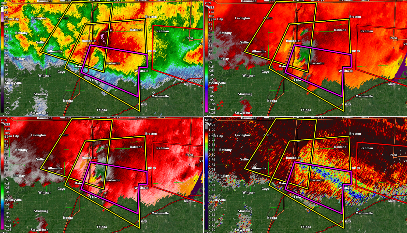
| Charleston 6:45PM: Reflectivity (top, left), SRV (top, right), Velocity (bottom, left), Correlation Coefficient (bottom, right) |
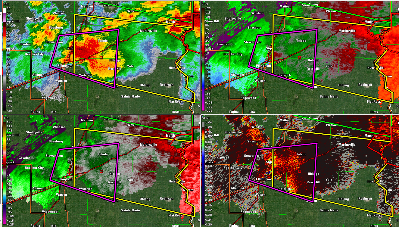
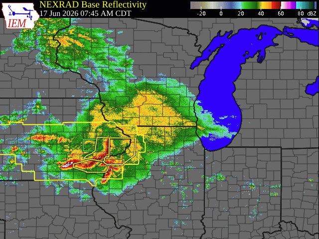
Effingham Area Tornado 8:13PM: Reflectivity (top, left), SRV (top, right), Velocity (bottom, left), Correlation Coefficient (bottom, right) | Regional Radar Mosaic capturing multiple waves of thunderstorms on June 17th, 2026 | Caption |
Environment
Several rounds of significant convection impacted central Illinois on June 17th, 2026. Clusters of thunderstorms initially formed on the nose of a strong low-level jet streak across Iowa during the pre-dawn hours, then tracked southeastward along a warm frontal boundary into central Illinois through midday. As the clusters organized into lines, 70-90mph wind gusts in Iowa prompted the issuance of a downstream Tornado Watch north of the I-70 corridor. With an unfavorably dry/stable boundary layer initially in place, only scattered damaging wind gusts were reported in north-central Illinois...with the most concentrated corridor of 60-70mph winds focused along a Galesburg...to Peoria...to Chenoa line.
Thunderstorms re-developed along a remnant outflow boundary from the morning convection by mid to late afternoon...with the most intense cells materializing along and south of a Springfield to Paris line where several tornadoes occurred and hail larger than baseballs (3" diameter) was reported across portions of Moultrie, Douglas, and Coles counties.
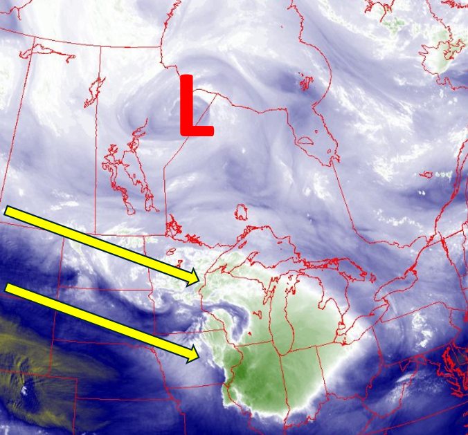
Mid-morning water vapor imagery (Figure 1) showed an unseasonably deep upper low centered over northern portions of Manitoba and Ontario (indicated by the red L on the image below)...while a vigorous polar jet stream was noted on the S/SW periphery of the low (yellow arrows). This type of synoptic pattern is more typical of April rather than June and resulted in unusually strong mid/upper level winds across the Northern Plains into the Midwest. In addition, note the series of curls embedded within the jet stream from North Dakota to Wisconsin. These short-wave troughs were providing additional synoptic lift as they tracked southeastward toward the southern Great Lakes.
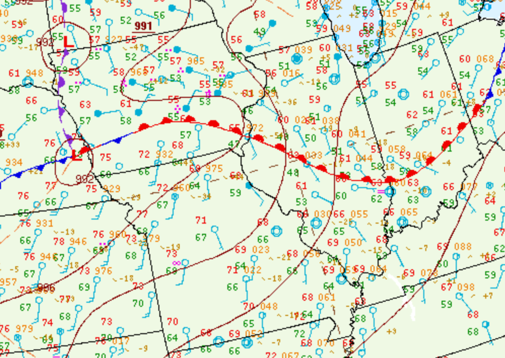
7AM CDT surface analysis (Figure 2) revealed a well-defined warm front extending from southern Iowa to southern Indiana. Dewpoints to the north of the boundary were only in the upper 40s and lower 50s across much of central Illinois, while much richer moisture characterized by dewpoints in the middle to upper 60s was noted south of the front across Kansas and Missouri.
Mesoanalysis from the Storm Prediction Center (SPC) showed the stable boundary layer (Figure 3) across central Illinois and highlighted the much more unstable environment south of the warm front where Surface Based Convective Available Potential Energy (SBCAPE) values ranged from 1500-2500J/kg across Kansas into western Missouri.
 |
 |
 |
| Figure 1: WATER VAPOR IMAGERY 1030AM CDT JUNE 17, 2026 | Figure 2: SURFACE MAP 7AM CDT JUNE 17, 2026 |
Figure 3: SURFACE BASED CAPE 9AM CDT JUNE 17, 2026 |
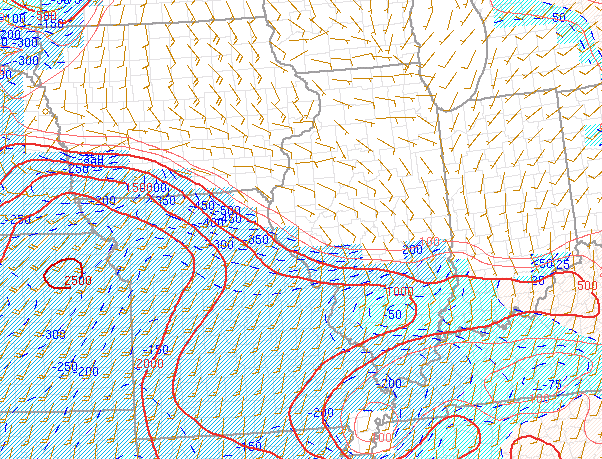
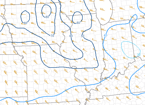
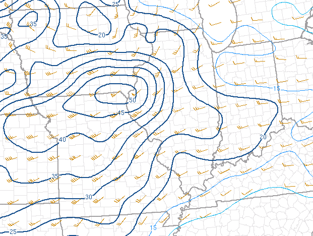
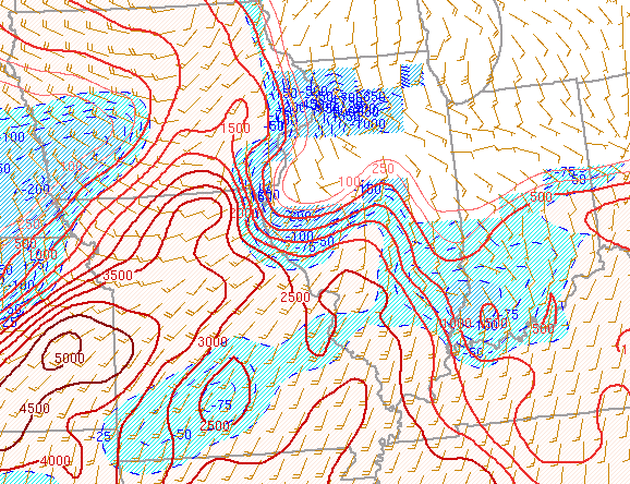
Given the very strong jet stream winds aloft, impressive deep-layer shear values of 50-70kt were evident (Figure 4). In addition, low-level 0-1km shear was maximized at 45-50kt near the warm front across northern Missouri and far southern Iowa (Figure 5). The 9am CDT Significant Tornado Parameter (STP, Figure 6) was maximized in the Kansas City area eastward into northern Missouri, while remaining below 0.5 across central Illinois.
 |
 |
 |
| Figure 4: 0-6KM SHEAR 9AM CDT JUNE 17, 2026 | Figure 5: 0-1KM SHEAR 9AM CDT JUNE 17, 2026 | Figure 6: SIGNIFICANT TORANDO PARAMETER 9AM CDT JUNE 17, 2026 |
As anticipated, thunderstorms initially developed on the nose of a 50-60kt low-level jet streak along the warm front across central and southern Iowa during the pre-dawn hours. Clusters of storms evolved into a linear structure, then began accelerating southeastward along the warm front after daybreak. With favorable inflow from the low-level jet supporting the convection, numerous wind gusts of 70-90mph were observed across eastern Iowa. As the line pushed eastward into the drier and more stable airmass across central Illinois, it gradually lost momentum: however, a corridor of 60-70mph gusts caused sporadic wind damage along a Galesburg...to Peoria....to Chenoa line. Further south along the trailing line, winds were considerably lighter, but still downed tree branches in a few locations. Note the well-defined squall line on the 9:31am CDT radar imagery below (Figure 7).
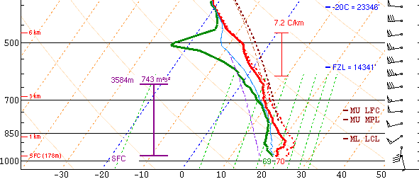
The early morning squall line pushed the warm front southward to a Hannibal, Missouri to Salem, Illinois line toward midday. At the same time, the strong low-level jet streak that had been oriented from the Texas panhandle northeastward to Iowa shifted eastward and directed its elevated moisture/instability inflow over the effective frontal boundary into central Illinois. This resulted in waves of mainly elevated thunderstorms with copious rainfall, but little in the way of wind or hail from late morning into the early afternoon. The showers and thunderstorms gradually tapered off and shifted further east, leading to a brief lull in precipitation by mid-afternoon. Given the break in the storms, NWS Lincoln launched a special weather balloon (Figure 8) in order to sample the storm environment. While the 3pm CDT sounding continued to show a stable boundary layer north of the warm front/outflow boundary with SBCAPEs of just 366J/kg, a large degree of both speed and directional shear was observed. Southeasterly surface winds of around 10kt veer to westerly and increased to 70-75kt at 12,000ft aloft. This created 0-6km bulk shear of 64kt and 0-1km shear of 47kt. Given strong southwesterly flow in the warm sector across Missouri and southern Illinois, the frontal boundary was expected to lift back northward later in the afternoon into the early evening. With extreme shear and an anticipated uptick in instability, concern was growing that supercell thunderstorms would rapidly initiate along the front. Thanks to a feed of warm/moist air from the south and plenty of shear to produce rotating updrafts, all severe hazards were expected with the storms...including tornadoes, damaging wind gusts in excess of 70mph, and hail larger that golf balls.
2pm mesoanalysis from SPC (Figure 9) showed a markedly destabilizing airmass within the warm sector across Missouri where SBCAPEs had increased into the 3000-4000J/kg range. While much of central Illinois was still relatively stable, the outflow boundary had edged northward...allowing the more unstable airmass to approach the I-72 corridor from the south.
 |
 |
 |
| Figure 7: RADAR IMAGERY 9:31AM CDT JUNE 17, 2026 |
Figure 8: NWS LINCOLN UPPER AIR SOUNDING 3PM CDT JUNE 17, 2026 | Figure 9: SURFACE BASED CAPE 2PM CDT JUNE 17, 2026 |
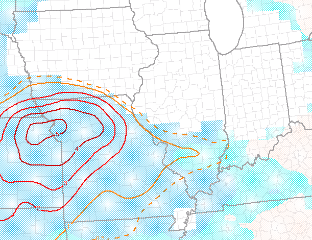
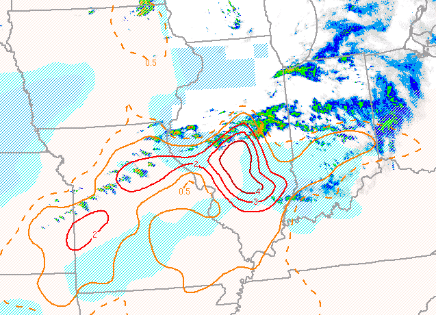
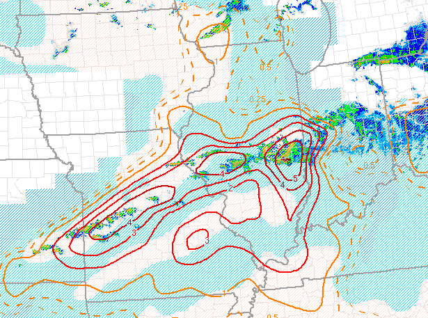
Subsequently, the Significant Tornado Parameter (STP, Figure 10) increased near the slowly moving boundary, with maximum values of 3-4 from near Springfield and Decatur southeastward toward Salem.
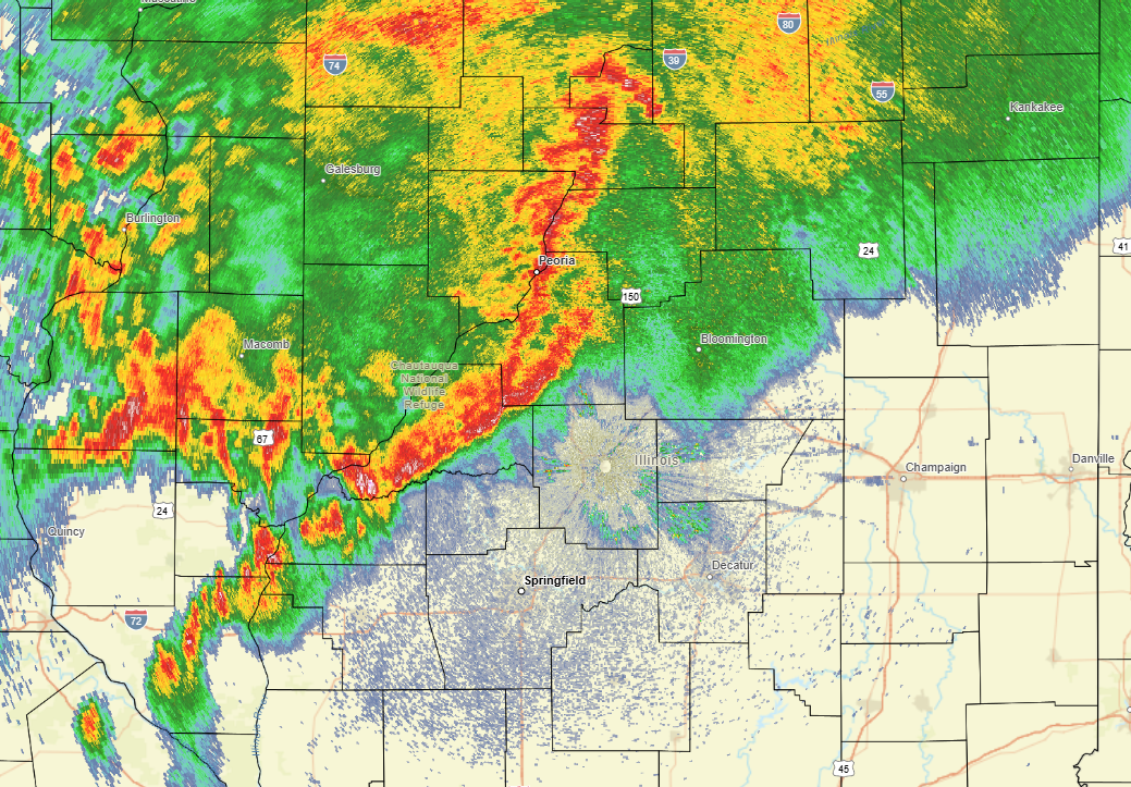
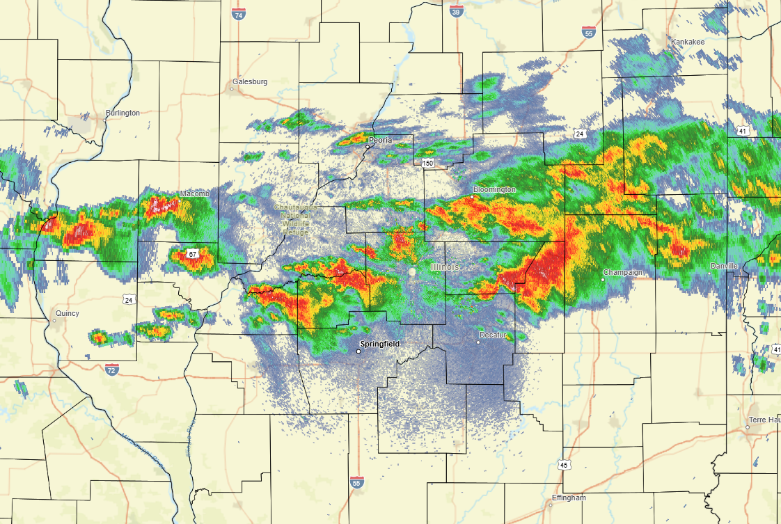
Shortly after 3pm, thunderstorms began developing north of the outflow boundary from far northern Missouri eastward toward Bloomington-Normal. As the atmosphere destabilized and the broken line of storms sagged further southeastward toward the higher low-level shear near the boundary, the storms quickly began rotating...prompting the issuance of numerous severe thunderstorm and tornado warnings. Note the developing hook echoes on the 4pm radar imagery below (Figure 11)...particularly with the cells over Cass, Menard, and northeastern Macon County.
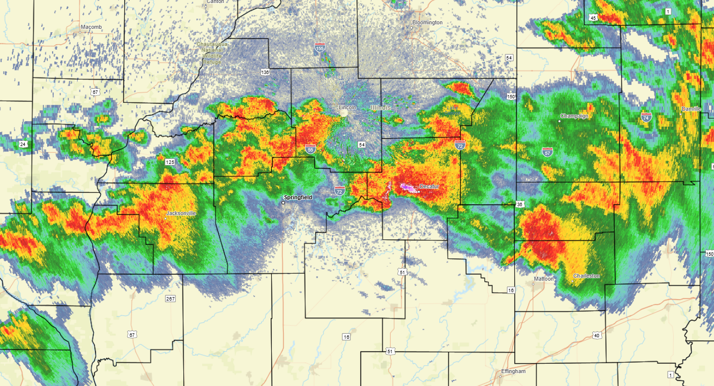
Storm structure continued to improve as the line pushed south of the I-72 corridor where low-level shear was strongest and the Significant Tornado Parameter (STP) was maximized. In the 5:51pm radar imagery (Figure 12), note the prominent supercell over Macon County. The high reflectivity core (pink color) resulted in golf ball-sized hail (1.75" diameter) in parts of Decatur and quarter-sized hail (1.00" diameter) at the Decatur Airport. The airport also logged a 78mph wind gust at around 6pm CDT.
 |
 |
 |
| Figure 10: Caption | Figure 11: RADAR IMAGERY 4PM CDT JUNE 17, 2026 |
Figure 12: RADAR IMAGERY 5:51PM CDT JUNE 17, 2026 |
By 6pm CDT, maximum values of the Significant Tornado Parameter (STP, Figure 13) had shifted into east-central Illinois along and south of the I-70 corridor and had increased to 4-6. This gave further confidence for the potential of strong tornadoes over the next few hours.
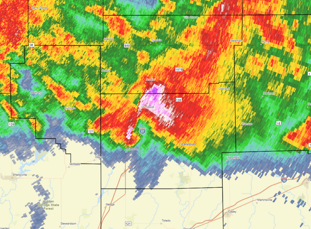
6:45pm CDT radar imagery (Figure 14) showed an intense supercell interacting with the highly favorable environment across east-central Illinois. A well-defined hook echo was evident just north of Mattoon. This storm went on to produce damage on the north side of Mattoon into parts of Charleston. In addition, the high-reflectivity core of the storm had a history of dropping hailstones larger than baseballs (3" diameter) near Arthur and Humboldt. This particular cell was part of a family of supercells that had produced a swath of large hail and possible tornadoes from far eastern Sangamon County near Illiopolis southeastward through Decatur, Arthur, and Charleston before it eventually weakened. As the evening progressed, additional tornadic supercells impacted locations south of I-70...including Effingham where significant damage was reported. The storms gradually shifted south and east of the NWS Lincoln County Warning Area (CWA) after 10pm CDT.
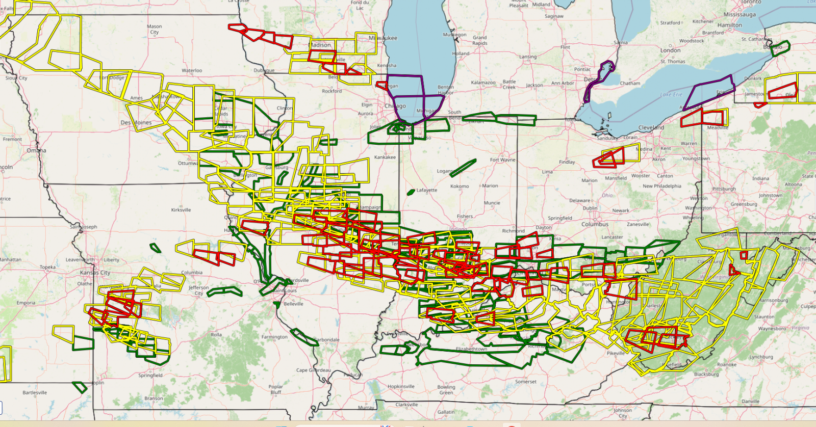
This was a significant weather event not only for central Illinois, but for surrounding areas as well. Figure 15 is a map highlighting all Severe Thunderstorm, Tornado, and Flash Flood Warnings issued by the National Weather Service on June 17th. A large swath of warnings stretched from Iowa southeastward into the Ohio River Valley. NWS Lincoln issued a total of 58 weather warnings.
 |
 |
 |
| Figure 13: SIGNIFICANT TORNADO PARAMETER 6PM CDT JUNE 17, 2026 | Figure 14: RADAR IMAGERY 6:45PM CDT JUNE 17, 2026 |
Figure 15: JUNE 17, 2026 WARNINGS |
Photos & Video
Header
 |
 |
|
|
| Tornado near Shumway, IL (Photo: Jon Hohulin) |
Tornado near Island Grove, IL (Photo: Ross Wolf) |
Tornado near Effingham, IL (Photo: Jakob McMillin) |
Caption (source) |
 |
Media use of NWS Web News Stories is encouraged! Please acknowledge the NWS as the source of any news information accessed from this site. |
|

