
Catastrophic Super Typhoon Bavi's eyewall has reached Rota and is expected to bring dangerous winds, heavy rainfall and storm surge to Guam, Rota, Tinian and Saipan. A Typhoon Warning remains in effect. Heavy to excessive rainfall will continue to bring a flooding threat from coastal Mid-Atlantic to southern New England through Monday. Read More >
Overview
|
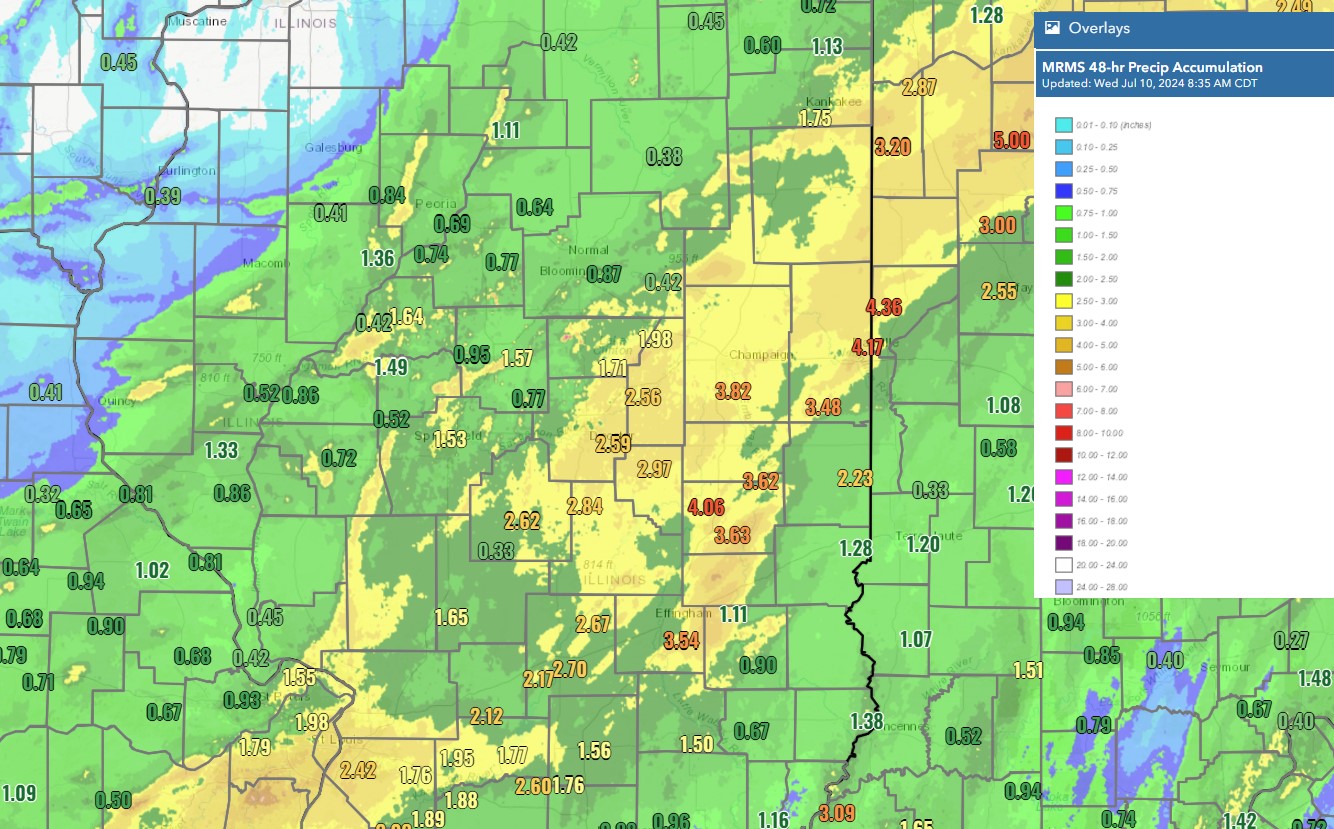
Hurricane Beryl, which was the earliest Category 5 hurricane on record in the Atlantic basin, struck the Windward Islands and moved across the Caribbean Sea before making landfall on the Yucatan Peninsula of Mexico. After weakening as it emerged in the Gulf of America, it restrengthened into a Category 1 hurricane before another landfall on the Texas coast southwest of Houston on Monday, July 8th. Its remnants tracked northeast and reached western Indiana by the evening on Tuesday, July 9th. Rainfall amounts of 2 to 5 inches occurred across portions of central and eastern Illinois, with the highest amounts in an area from around Mattoon northeast to Danville. Some flooding of farm fields and roads occurred as a result, especially near the I-57 corridor. As the system pulled further away from our area, some wind gusts of 25-40 mph occurred, with one gust of 54 mph in west central Indiana near Lafayette. While not common, tropical remnants have been known to track across Illinois. Click here to view a history of how they have impacted our area. |
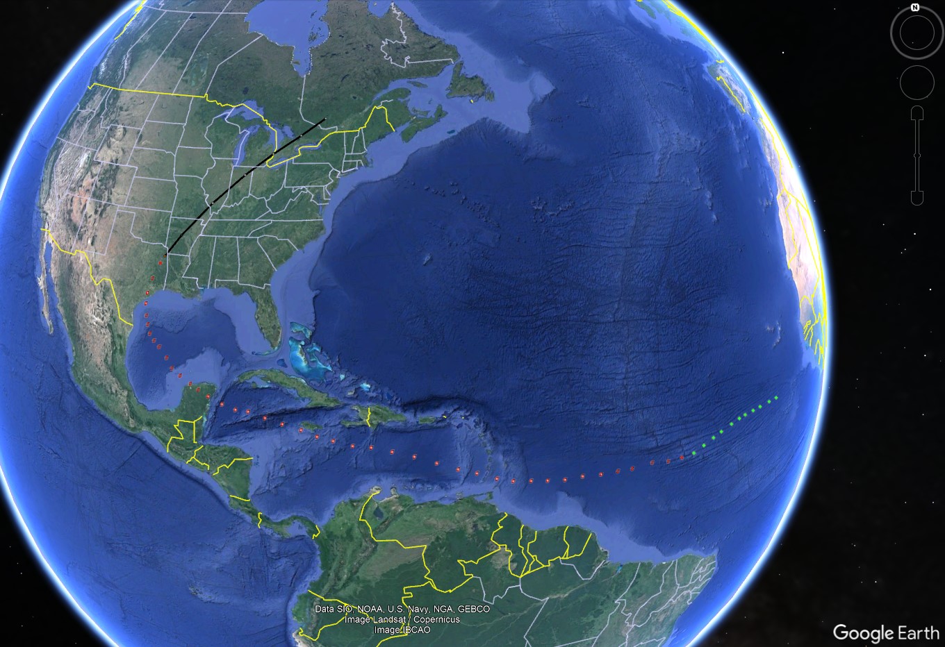 Approximate track of Beryl, from its formation off the Africa coast to its post-tropical phase over the Midwest. Image from Google Earth. |
Storm Reports
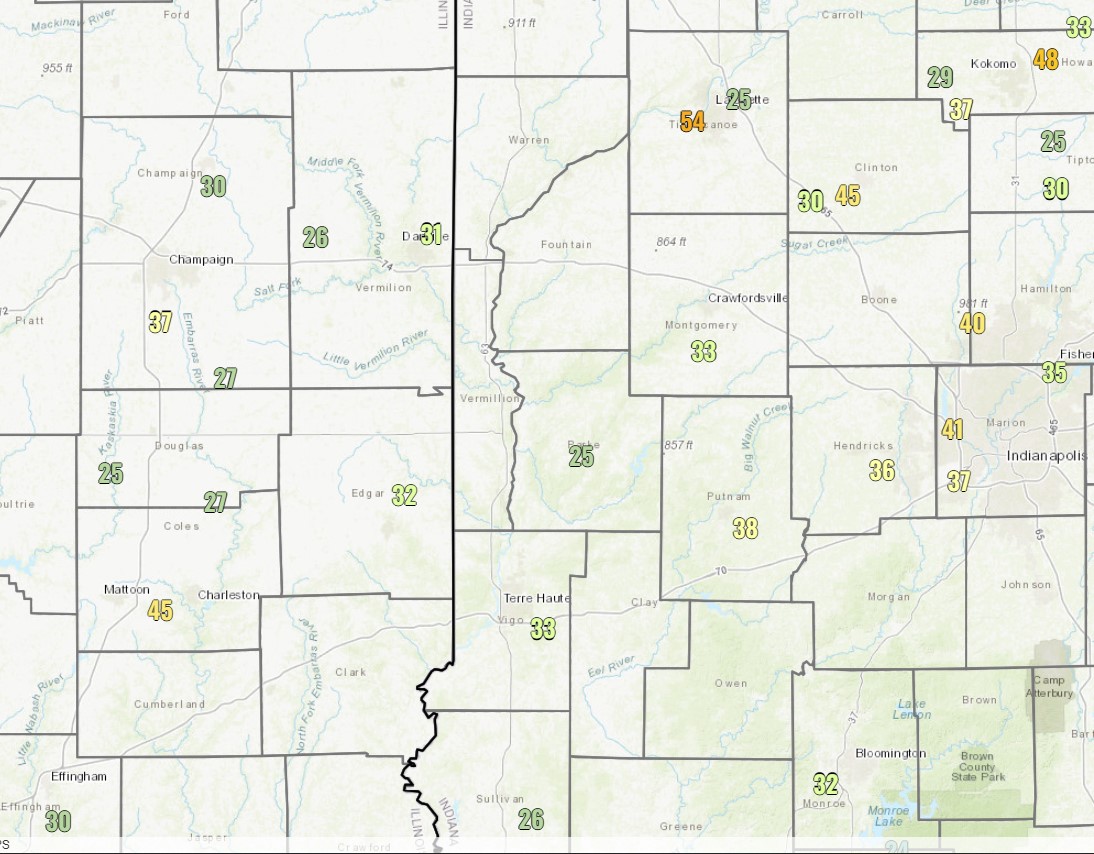
As the storm system pulled away from Illinois, it produced wind gusts of 25 to 40 mph in eastern Illinois and western Indiana. The highest wind gust in Illinois was 45 mph at the Coles County Airport near Mattoon.
Rain Reports
Public Information Statement National Weather Service Lincoln IL 859 AM CDT Wed Jul 10 2024 ...48-HOUR PRECIPITATION REPORTS... Location Amount Time/Date Provider ...Illinois... ...Cass County... 3 SE Bluff Springs 0.82 in 0630 AM 07/10 COCORAHS Beardstown 0.77 in 0850 AM 07/10 CWOP ...Champaign County... Urbana 2.2 SE 4.39 in 0700 AM 07/10 COCORAHS Urbana 4.18 in 0850 AM 07/10 CWOP 2 ESE Urbana 4.10 in 0845 AM 07/10 AWS Urbana 1.9 ENE 4.04 in 0700 AM 07/10 COCORAHS Homer 2.1 NNE 4.01 in 0700 AM 07/10 COCORAHS Urbana 3.94 in 0700 AM 07/10 COCORAHS Champaign 2.5 S 3.90 in 0700 AM 07/10 COCORAHS Urbana 2.6 ENE 3.87 in 0700 AM 07/10 COCORAHS Urbana 1.8 S 3.87 in 0800 AM 07/10 COCORAHS Homer 2.0 NW 3.86 in 0800 AM 07/10 COCORAHS Philo 3.85 in 0700 AM 07/10 COCORAHS Sidney 0.9 N 3.84 in 0620 AM 07/10 COCORAHS Urbana 1.6 ESE 3.81 in 0645 AM 07/10 COCORAHS Ogden 3.80 in 0600 AM 07/10 COOP Willard Arpt 3.80 in 0753 AM 07/10 ASOS Champaign 0.3 ESE 3.79 in 0830 AM 07/10 COCORAHS Homer 2.0 N 3.78 in 0700 AM 07/10 COCORAHS Champaign 0.3 NNE 3.78 in 0800 AM 07/10 COCORAHS Champaign 2.3 SSE 3.74 in 0800 AM 07/10 COCORAHS Champaign 2.4 SSE 3.73 in 0800 AM 07/10 COCORAHS Urbana 3.73 in 0700 AM 07/10 COCORAHS Urbana 0.1 SSE 3.72 in 0700 AM 07/10 COCORAHS Champaign 3S 3.72 in 0800 AM 07/10 COOP Champaign 2.2 SSE 3.71 in 0700 AM 07/10 COCORAHS Urbana 3.71 in 0846 AM 07/10 CWOP Urbana 1.2 NNE 3.70 in 0700 AM 07/10 COCORAHS Champaign 1.3 SSW 3.69 in 0700 AM 07/10 COCORAHS Savoy 0.6 SSE 3.69 in 0700 AM 07/10 COCORAHS Homer 2.0 WSW 3.68 in 0630 AM 07/10 COCORAHS Penfield 2.6 N 3.65 in 0700 AM 07/10 COCORAHS Champaign 2.9 SSW 3.64 in 0700 AM 07/10 COCORAHS Champaign 0.6 NNE 3.61 in 0600 AM 07/10 COCORAHS 0.7 SE Champaign 3.57 in 0800 AM 07/10 HADS Urbana 0.5 W 3.55 in 0700 AM 07/10 COCORAHS Champaign 2.6 WNW 3.37 in 0700 AM 07/10 COCORAHS Champaign 2.2 NW 3.32 in 0700 AM 07/10 COCORAHS St. Joseph 1.1 ENE 3.28 in 0600 AM 07/10 COCORAHS Homer 0.6 NNW 3.25 in 0704 AM 07/10 COCORAHS 3 WSW Homer 3.16 in 0845 AM 07/10 AWS Champaign 3.5 SSE 3.15 in 0700 AM 07/10 COCORAHS Mahomet 1.8 ENE 3.06 in 0700 AM 07/10 COCORAHS Mahomet 3.0 NE 3.05 in 0700 AM 07/10 COCORAHS Rantoul 1.1 NE 3.00 in 0337 AM 07/10 COCORAHS Champaign 9SW 2.98 in 0800 AM 07/10 HADS Urbana 2.98 in 0845 AM 07/10 CWOP Mahomet 1.6 E 2.95 in 0645 AM 07/10 COCORAHS Mahomet 1.0 NW 2.90 in 0700 AM 07/10 COCORAHS Broadlands 0.1 SSW 2.85 in 1201 AM 07/10 COCORAHS Mahomet 1.7 NNE 2.82 in 0700 AM 07/10 COCORAHS Mahomet 2.76 in 0700 AM 07/10 COCORAHS Mahomet 1.2 S 2.70 in 0700 AM 07/10 COCORAHS 1 NE Rantoul 2.66 in 0800 AM 07/10 COCORAHS Foosland 5.0 ENE 2.64 in 0700 AM 07/10 COCORAHS Fisher 2.54 in 0700 AM 07/10 COOP 2.5 W Champaign 2.51 in 0815 AM 07/10 USGS Dewey 2.70 NW 2.41 in 0756 AM 07/10 COCORAHS ...Christian County... 2.5 W Taylorville 2.72 in 0700 AM 07/10 COOP Taylorville Arpt 2.66 in 0835 AM 07/10 AWOS Pana 2.41 in 0600 AM 07/10 COOP Pana 6.2 NNE 2.41 in 0700 AM 07/10 COCORAHS Morrisonville 2.29 in 0847 AM 07/10 CWOP Morrisonville 0.5 SSE 2.20 in 0730 AM 07/10 COCORAHS Edinburg 3.0 W 1.72 in 0700 AM 07/10 COCORAHS ...Clark County... Casey 1.95 in 0730 AM 07/10 COOP Marshall 1.1 SSW 1.40 in 0600 AM 07/10 COCORAHS Marshall 1.39 in 0850 AM 07/10 CWOP ...Clay County... Flora 1.70 in 0700 AM 07/10 UCOOP Clay City 6 SSE 1.30 in 0600 AM 07/10 COOP ...Coles County... Charleston 4.7 SSW 4.74 in 0800 AM 07/10 COCORAHS Mattoon 0.5 NW 4.36 in 0700 AM 07/10 COCORAHS Mattoon 4.23 in 0800 AM 07/10 COOP Coles Co. Mem AP 3.79 in 0753 AM 07/10 ASOS ...Cumberland County... Neoga 4.00 in 0615 AM 07/10 COOP ...De Witt County... Farmer City 1.5 SSW 1.85 in 0700 AM 07/10 COCORAHS Lane 1.66 in 0821 AM 07/10 CWOP Farmer City 2.7 WSW 1.65 in 0600 AM 07/10 COCORAHS Clinton 1SSW 1.18 in 0700 AM 07/10 COOP Waynesville 0.97 in 0846 AM 07/10 CWOP ...Douglas County... Hindsboro 5.09 in 0840 AM 07/10 CWOP Tuscola 3.88 in 0700 AM 07/10 COOP Tuscola 0.5 WSW 3.88 in 0700 AM 07/10 COCORAHS Arcola 3.66 in 0845 AM 07/10 CWOP 1.5 NE Chesterville 3.54 in 0830 AM 07/10 USGS Camargo 4.5 ESE 3.48 in 0703 AM 07/10 COCORAHS Newman 3.38 in 0600 AM 07/10 COCORAHS Camargo 3.20 in 0845 AM 07/10 AWS ...Edgar County... Paris 6.0 SSW 2.64 in 0700 AM 07/10 COCORAHS Edgar Co. Arpt 2.25 in 0835 AM 07/10 AWOS ...Effingham County... Teutopolis 3.4 SE 4.15 in 0730 AM 07/10 COCORAHS Watson 3.27 in 0845 AM 07/10 CWOP Dieterich 10.1 SW 3.15 in 0700 AM 07/10 COCORAHS Effingham 2.3 WNW 2.88 in 0700 AM 07/10 COCORAHS Teutopolis 2.75 in 0845 AM 07/10 CWOP Effingham 4.2 WNW 2.70 in 0643 AM 07/10 COCORAHS Beecher City 2.66 in 0710 AM 07/10 COOP Altamont 3.8 SSW 2.64 in 0740 AM 07/10 COCORAHS Effingham Arpt 2.17 in 0835 AM 07/10 AWOS Altamont 2.16 in 0849 AM 07/10 AWS ...Fulton County... Canton 1.2 ESE 1.63 in 0700 AM 07/10 COCORAHS Canton 1.39 in 0700 AM 07/10 COOP Lewistown 0.3 W 0.79 in 0700 AM 07/10 COCORAHS Lewistown 0.78 in 0845 AM 07/10 CWOP Avon 0.67 in 0700 AM 07/10 COOP Bryant 0.1 ENE 0.64 in 0613 AM 07/10 COCORAHS 0.7 W London Mills 0.54 in 0745 AM 07/10 USGS ...Jasper County... Yale 0.1 SSW 2.10 in 0700 AM 07/10 COCORAHS Newton 1.95 in 0845 AM 07/10 CWOP 1.1 W Newton 1.95 in 1200 AM 07/10 COOP Newton 1.75 in 0845 AM 07/10 CWOP ...Knox County... Yates City 0.96 in 0625 AM 07/10 COOP Delong 0.66 in 0849 AM 07/10 CWOP Williamsfield 1.7 NNE 0.43 in 0630 AM 07/10 COCORAHS Galesburg Arpt 0.33 in 0835 AM 07/10 AWOS Altona 4.7 ESE 0.19 in 0700 AM 07/10 COCORAHS Knoxville 0.12 in 0800 AM 07/10 COOP ...Lawrence County... Lawrenceville AP 1.47 in 0753 AM 07/10 ASOS 1.7 W Lawrenceville 1.12 in 0800 AM 07/10 COOP 1 W Lawrenceville 1.12 in 0800 AM 07/10 COCORAHS ...Logan County... Lincoln 2.05 in 0600 AM 07/10 COCORAHS Lincoln 2 ENE 1.95 in 0700 AM 07/10 OFFICIAL NWS OBS 6 NE Lincoln 1.92 in 0700 AM 07/10 COCORAHS Lincoln 0.6 NNW 1.79 in 0700 AM 07/10 COCORAHS Lincoln 2.0 ENE 1.69 in 0730 AM 07/10 COCORAHS 2 NW Chestnut 1.40 in 0530 AM 07/10 COCORAHS Elkhart 0.7 ENE 1.30 in 0630 AM 07/10 COCORAHS Chestnut 1.9 W 1.12 in 0700 AM 07/10 COCORAHS Mount Pulaski 1.02 in 0400 AM 07/10 COOP ...Macon County... Decatur Arpt 2.86 in 0754 AM 07/10 ASOS Decatur 3.2 SW 2.69 in 0730 AM 07/10 COCORAHS Decatur 1 SSE 2.59 in 1200 AM 07/10 COOP 2 S Oreana 2.52 in 0800 AM 07/10 COCORAHS 2 NNW Elwin 2.19 in 0850 AM 07/10 AWS Warrensburg 0.6 E 1.41 in 0700 AM 07/10 COCORAHS Latham 1.8 SE 1.25 in 0800 AM 07/10 COCORAHS ...Marshall County... Henry 1.4 SW 1.92 in 0645 AM 07/10 COCORAHS Lacon Arpt 1.11 in 0835 AM 07/10 AWOS Henry 0.81 in 0846 AM 07/10 CWOP ...Mason County... Havana 3.0 E 1.82 in 0742 AM 07/10 COCORAHS ...McLean County... Saybrook 4.3 SSE 1.92 in 0700 AM 07/10 COCORAHS Le Roy 4.2 WSW 1.48 in 0700 AM 07/10 COCORAHS Bloomington 1.6 WSW 1.28 in 0700 AM 07/10 COCORAHS Bloomington 3.9 ESE 1.22 in 0600 AM 07/10 COCORAHS Bloomington 3.8 SW 1.21 in 0700 AM 07/10 COCORAHS Bloomington 1.5 ESE 1.16 in 0700 AM 07/10 COCORAHS Bloomington 5.0 WSW 1.15 in 0700 AM 07/10 COCORAHS Bloomington 0.95 in 0700 AM 07/10 COOP Normal 1.2 ESE 0.94 in 0700 AM 07/10 COCORAHS Cooksville 0.90 in 0845 AM 07/10 CWOP 3 W Ellsworth 0.89 in 0700 AM 07/10 COCORAHS Downs 2 NW 0.86 in 0800 AM 07/10 COCORAHS 4 NE Normal 0.84 in 0500 AM 07/10 COOP Carlock 0.1 ESE 0.82 in 0730 AM 07/10 COCORAHS Normal 1.4 WNW 0.78 in 0700 AM 07/10 COCORAHS Towanda 0.78 in 0848 AM 07/10 CWOP Bloomington Arpt 0.77 in 0756 AM 07/10 AWOS ...Menard County... 1.9 NW Oakford 1.48 in 0745 AM 07/10 USGS Athens 4 WSW 1.12 in 0600 AM 07/10 COOP Petersburg 6.5 SSE 1.12 in 0600 AM 07/10 COCORAHS Petersburg 0.2 W 1.06 in 0630 AM 07/10 COCORAHS Petersburg 1.3 N 1.04 in 0700 AM 07/10 COCORAHS 3.3 N Greenview 1.01 in 0745 AM 07/10 USGS ...Morgan County... 1 NNE Jacksonville Airport 2.38 in 0700 AM 07/10 COCORAHS 0.8 SW Meredosia 1.67 in 1100 PM 07/09 HADS Jacksonville 1.2 SW 1.53 in 0631 AM 07/10 COCORAHS Jacksonville 1.50 in 0700 AM 07/10 COOP Jacksonville 2.6 SE 1.38 in 0700 AM 07/10 COCORAHS 2.0 E Jacksonville 0.87 in 0530 AM 07/10 COOP 0.8 SW Meredosia 0.85 in 0830 AM 07/10 HADS Murrayville 0.82 in 0600 AM 07/10 COCORAHS Jacksonville Arpt 0.57 in 0835 AM 07/10 AWOS ...Moultrie County... Arthur 0.8 NNW 3.65 in 0500 AM 07/10 COCORAHS Arthur 1W 3.60 in 0730 AM 07/10 COOP Lovington 3.40 in 0600 AM 07/10 COOP Lovington 4.1 NNW 3.10 in 0700 AM 07/10 COCORAHS 2.0 NW Lovington 2.04 in 0830 AM 07/10 USGS ...Peoria County... Trivoli 0.4 E 1.69 in 0700 AM 07/10 COCORAHS PEORIA 1.45 in 0848 AM 07/10 CWOP Trivoli 1.3 W 1.35 in 0600 AM 07/10 COCORAHS Peoria 3.4 WNW 1.02 in 0700 AM 07/10 COCORAHS Peoria Heights 0.90 in 0845 AM 07/10 AWS Peoria Heights 0.89 in 0850 AM 07/10 CWOP Dunlap 2.6 S 0.81 in 0700 AM 07/10 COCORAHS Peoria 5 NW 0.80 in 0800 AM 07/10 COOP Peoria Intl Arpt 0.78 in 0754 AM 07/10 ASOS Dunlap 2.6 NE 0.67 in 0758 AM 07/10 COCORAHS 2 ESE Edelstein 0.65 in 0700 AM 07/10 COCORAHS 0.9 E Chillicothe 0.54 in 0800 AM 07/10 HADS ...Piatt County... 4 NE Hammond 3.88 in 0800 AM 07/10 COCORAHS Bement 1.5 SE 2.94 in 0700 AM 07/10 COCORAHS Monticello 6.5 WSW 2.82 in 0700 AM 07/10 COCORAHS 4 N Cerro Gordo 2.79 in 0700 AM 07/10 COCORAHS White Heath 3.7 NNE 2.79 in 0800 AM 07/10 COCORAHS 3 S Mansfield 2.60 in 0700 AM 07/10 COCORAHS Cisco 2.58 in 0600 AM 07/10 COOP Cisco 2.1 NNE 2.56 in 0730 AM 07/10 COCORAHS Mansfield 3.2 NE 2.50 in 0800 AM 07/10 COCORAHS ...Richland County... Olney 2 S 0.98 in 0600 AM 07/10 COOP Olney 1.5 NE 0.94 in 0800 AM 07/10 COCORAHS Olney Noble AP 0.84 in 0835 AM 07/10 AWOS Olney 0.73 in 0845 AM 07/10 CWOP ...Sangamon County... Springfield 2.6 WNW 1.80 in 0700 AM 07/10 COCORAHS Springfield 2.0 N 1.64 in 0639 AM 07/10 COCORAHS Pawnee 1.56 in 0845 AM 07/10 CWOP Springfield 1.54 in 0850 AM 07/10 CWOP Spfld Capital AP 1.53 in 0843 AM 07/10 ASOS Springfield 1.49 in 0846 AM 07/10 CWOP Springfield 4.4 W 1.44 in 0700 AM 07/10 COCORAHS Sherman 1.30 in 0700 AM 07/10 COOP 1 ESE Chatham 1.29 in 0700 AM 07/10 COCORAHS Springfield 2.2 SE 1.25 in 0700 AM 07/10 COCORAHS 1 SSE Grandview 1.24 in 0848 AM 07/10 AWS Plainfield 1.10 in 0849 AM 07/10 CWOP 2 W Riverton 1.03 in 0600 AM 07/10 COCORAHS 1.5 W Rochester 1.03 in 0745 AM 07/10 USGS Buffalo 0.89 in 0700 AM 07/10 COOP Chatham 0.88 in 0845 AM 07/10 CWOP ...Schuyler County... Illinois River 0.85 in 0745 AM 07/10 HADS Browning 0.72 in 0845 AM 07/10 CWOP Rushville 3.9 ESE 0.64 in 0700 AM 07/10 COCORAHS 0.6 NE Ripley 0.52 in 0745 AM 07/10 COOP Rushville 0.42 in 0845 AM 07/10 CWOP ...Scott County... Florence 0.84 in 0830 AM 07/10 HADS ...Shelby County... Shelbyville 0.5 NE 3.10 in 0700 AM 07/10 COCORAHS Moweaqua 2 S 2.86 in 0600 AM 07/10 COOP 1.6 SE Cowden 2.44 in 0830 AM 07/10 USGS 1.5 E Shelbyville 1.45 in 0830 AM 07/10 HADS 3.6 E Tower Hill 1.19 in 0830 AM 07/10 USGS ...Stark County... Toulon 0.5 ESE, IL 0.90 in 0631 AM 07/10 COCORAHS ...Tazewell County... Morton 1.04 in 0700 AM 07/10 COOP Pekin 0.91 in 0845 AM 07/10 CWOP East Peoria 0.90 in 0849 AM 07/10 CWOP Morton 5.1 E 0.89 in 0700 AM 07/10 COCORAHS East Peoria 0.87 in 0841 AM 07/10 CWOP Pekin 0.84 in 0848 AM 07/10 CWOP Eureka 3.5 W 0.83 in 0613 AM 07/10 COCORAHS Washington 0.82 in 0845 AM 07/10 CWOP Washington 1.7 NE 0.78 in 0700 AM 07/10 COCORAHS 1 NNW Morton 0.77 in 0849 AM 07/10 AWS Tremont 3.6 E 0.77 in 0625 AM 07/10 COCORAHS Washington 0.73 in 0841 AM 07/10 CWOP 1.0 E East Peoria 0.71 in 0745 AM 07/10 HADS Goodfield 0.69 in 0845 AM 07/10 CWOP ...Vermilion County... Danville 5.56 in 0846 AM 07/10 CWOP Danville 4.86 in 0607 AM 07/10 COCORAHS Henning 3.4 SE 4.67 in 0700 AM 07/10 COCORAHS Danville 3.1 NNW 4.62 in 0615 AM 07/10 COCORAHS Danville 1.1 WNW 4.48 in 0715 AM 07/10 COCORAHS Danville 4.2 NW 4.43 in 0538 AM 07/10 COCORAHS Danville 0.7 NNW 4.42 in 0545 AM 07/10 COCORAHS Hoopeston 0.6 E 4.32 in 0400 AM 07/10 COCORAHS Danville Arpt 4.22 in 0835 AM 07/10 AWOS Sidell 4N 4.18 in 0700 AM 07/10 COOP Fithian 0.6 NNW 4.01 in 0700 AM 07/10 COCORAHS Fithian 2.6 ESE 3.83 in 0700 AM 07/10 COCORAHS Fithian 3.69 in 0850 AM 07/10 CWOP Georgetown 0.1 NNW 3.57 in 0700 AM 07/10 COCORAHS Westville 0.1 W 3.50 in 0612 AM 07/10 COCORAHS 2.3 E Tilton 3.35 in 1200 AM 07/10 COOP Hope 3.09 in 0845 AM 07/10 CWOP ...Woodford County... Metamora 6.4 W 1.04 in 0800 AM 07/10 COCORAHS Germantown Hills 0.5 SSW 0.97 in 0700 AM 07/10 COCORAHS East Peoria 6.9 NNE 0.86 in 0700 AM 07/10 COCORAHS 1 NW Metamora 0.81 in 0846 AM 07/10 CWOP Metamora 1.1 WNW 0.72 in 0631 AM 07/10 COCORAHS Roanoke 0.71 in 0700 AM 07/10 COOP Eureka 0.65 in 0845 AM 07/10 CWOP Congerville 0.64 in 0745 AM 07/10 HADS 2 N Panola 0.63 in 0845 AM 07/10 AWS Congerville 0.6 WSW 0.61 in 0700 AM 07/10 COCORAHS Observations are collected from a variety of sources with varying equipment and exposures. We thank all volunteer weather observers for their dedication. Not all data listed are considered official.
 |
Media use of NWS Web News Stories is encouraged! Please acknowledge the NWS as the source of any news information accessed from this site. |
|

