
Anomalously warm, dry and breezy conditions will bring elevated to critical fire weather conditions across portions of the Intermountain West into the Plains though early this week. Another elevated risk is possible across the central Appalachians. A rapid warm-up is in the forecast beginning Monday across the central and eastern U.S.. Read More >
Forecasting lake effect snow is a significant forecasting challenge in the Great Lakes during the winter months. There are numerous factors that determine the intensity and location of lake effect snow bands including the available moisture, instability (propensity for the air to rise if forced upwards), wind speed, and wind direction to name a few. One factor that is important with respect to the intensity of lake effect snow is the "fetch". Fetch is essentially the distance that air must travel from the upwind side of the lake (Wisconsin) to the downwind side of the lake (Michigan). A longer "fetch" enables more warmth and moisture to be added to the air as it crosses the lake and this typically results in stronger lake effect snow bands As for the location of where the heaviest snow will fall over land, wind direction is probably the most important factor.
Wind direction is measured in degrees, as on a compass where 360 degrees is north, 90 degrees is east, 180 degrees is south, and 270 degrees is west. Since Lake Michigan is elongated north-south, and since southwest lower Michigan is on the eastern edge of it, lake effect snow from Lake Michigan will generally occur when the wind has a westerly component to it. Wind with an easterly component will result in lake effect snow remaining offshore of southwest lower Michigan.
The forecast area of the Grand Rapids National Weather Service office includes the stretch of Lake Michigan shore from near Ludington to South Haven. This discussion will focus on the impact of wind direction on the location of lake effect snow bands between these two locations. Research has shown that the prevailing wind direction will affect the location of the heaviest lake effect snow that occurs along specific areas of the coast and the adjacent inland areas. To examine where the heaviest snow will fall under different prevailing wind directions, we will begin from near northerly flow or 360 degrees, and then transition to near southerly flow or 180 degrees. The maps below are color coded to indicate the threat that a particular county would have for heavy snow for a given range in wind direction (with the assumption that other indicators are favorable for the development of significant lake effect snow). Counties highlighted in red would have a significant threat for receiving heavy snow for the given wind direction while counties colored in blue would have a moderate threat.
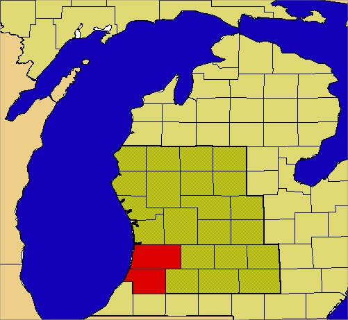
At near northerly flow, where the wind direction is from 325 to 350 degrees, the heaviest lake effect snow will occur across Allegan and Van Buren Counties. The lake effect snow bands will originate across northern Lake Michigan and may clip Big and Little Sable points in extreme western Mason and Oceana Counties, respectively.The snow bands then come ashore in the area from Saugatuck to South Haven and may affect areas as far inland as Kalamazoo.
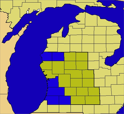
When the flow is more northwest, from 305 to 325 degrees, the heaviest snow area is more expansive and includes Ottawa and Kalamazoo Counties in addition to Allegan and Van Buren Counties. This includes Kalamazoo and Holland as well as Saugatuck and South Haven. A separate area further north consisting of Mason and Lake Counties also sees heavy snow, including Ludington and Baldwin. This may be a result of a favorable trajectory for lake effect snow bands that form over Lake Superior to pass over northern Lake Michigan before coming ashore in the area from Manistee to Ludington. This "Lake Superior Connection" can occur in the northerly flow regime as well, but the bands remain offshore of Mason County, or only clip Big Sable Point, as discussed above.
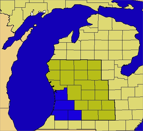
West-northwest flow, from 280 to 305 degrees, typically produces heavy lake effect snow across the same region as northwest flow, except for Lake and Mason Counties, as the "Lake Superior Connection" snow bands will tend to come inland much further north than Ludington. Ottawa, Allegan, Van Buren and Kalamazoo Counties are still affected from the bands that originate across northern or central Lake Michigan.
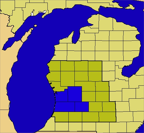
Westerly flow, from 280 to 260 degrees, typically brings the heaviest lake effect snow to areas from Grand Haven to South Haven and inland to Grand Rapids and Hastings. This is a function of fetch, as well as wind direction. Although most, if not all of the coast from Ludington to South Haven will see lake effect snow with westerly flow, the heaviest snow can be expected to occur where the fetch is greatest. Indeed, a look at the map shows that Lake Michigan is widest adjacent to the areas where the heaviest snow tends to occur.
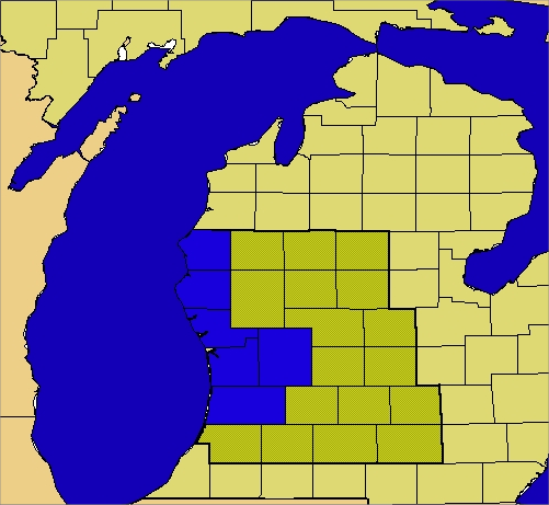
West-Southwest flow, from 235 to 260 degrees, results in heavier snow falling from Allegan, Ottawa, Muskegon, Kent, Oceana and Mason Counties. The relatively short fetch across Lake Michigan results in the heaviest snow being concentrated nearest to the shore. Among the inland locations, only Kent County manages to see some heavier snow as the snow bands that reach here have a longer fetch across central Lake Michigan.
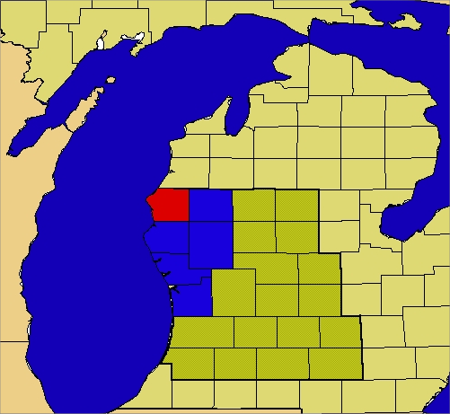
For southwest flow, from 215 to 235 degrees, Mason County is most favored for heavy snow, with Lake, Oceana, Newyago, Muskegon and Ottawa Counties also seeing some heavier lake effect snow. Again the longer fetch plays a role, as the snow bands with the longest time over water will be coming ashore in Mason County.
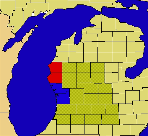
For southerly flow, from 190 to 215 degrees, Mason and Oceana Counties are most favored, with Ottawa and Muskegon Counties also picking up some heavier snow. Once again, the snow bands with the longest fetch will be providing the heaviest snow. The southerly flow will mean that the snow will be occurring relatively close to the coast. It should be pointed out that the cases with southerly or southwesterly flow are much less common than the northerly or northwest flow cases, as southerly flow will usually occur when warmer air is moving across the lakes, resulting in less favorable conditions for lake effect snow bands to form.