Tropical Depression Two is expected to gradually strengthen and could bring tropical storm conditions to the Florida Panhandle beginning late Monday. Areas of flash flooding will be possible through Thursday along the eastern and central Gulf Coast. Severe thunderstorms will develop and move along a cold front crossing the Upper Midwest Monday, and through the Ohio Valley/Mid-Atlantic on Tuesday. Read More >
January 28 - 31, 2019: Days of Snow, Low Visibility, and Extreme Cold
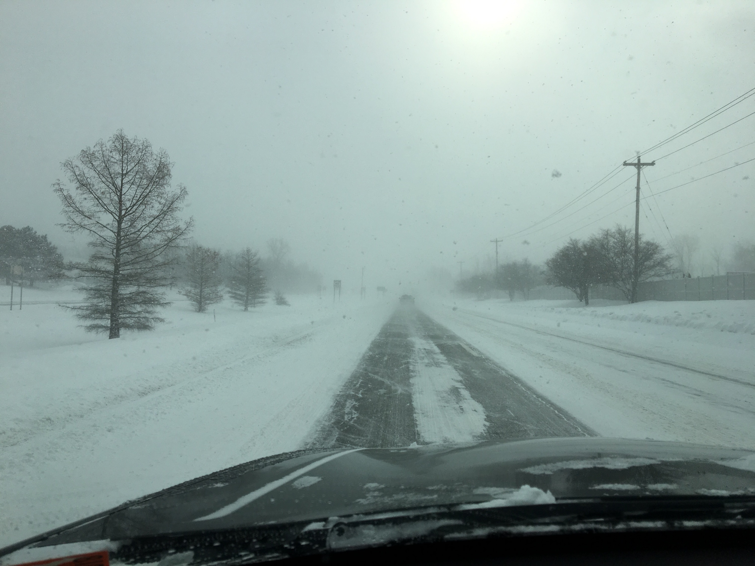 |
| A typical scene across Lower Michigan during the cold and snow event with low visibility due to blowing snow and hazardous driving conditions. Photo taken on 1/29/2019 in the Grand Rapids area. |
Much of the Midwest experienced an arctic cold outbreak and a prolonged period of falling and blowing snow during the last few days of January. More than a foot of snow fell across parts of Lower Michigan with wind chills from -20 to -40 F. The combination of the extreme cold and snow led to dangerous and life-threatening travel conditions across the state closing schools and businesses for a number of days. Additionally, numerous car pile-ups led to the closure of many area roadways, highways, and interstates. The remarkable longevity of the cold and snowy conditions combined with the sheer number of impacts from school, business, and road closures will surely make the end of January 2019 remembered for years.
Web Stories Created by Neighboring NWS Offices:
Extreme Cold
Dangerous to life-threatening cold invaded the Midwest leading to some of the coldest air in Lower Michigan in decades. Winds off of Lake Michigan protected northern and central portions of Lower Michigan from the coldest temperatures and wind chills, but areas mainly along and south of I-94 faced the full brunt of the arctic outbreak as winds curved around the lake. All in all, low temperatures were coldest on the mornings of 1/30 and 1/31 with values of -5 to -20 F with dangerously cold wind chills of -20 to -40 F, coldest where the influences of Lake Michigan were not applicable. The highs on 1/30 and 1/31 also struggled to climb into the single digits above zero, making the 2-day period one of the coldest stretches in Lower Michigan since 1994.
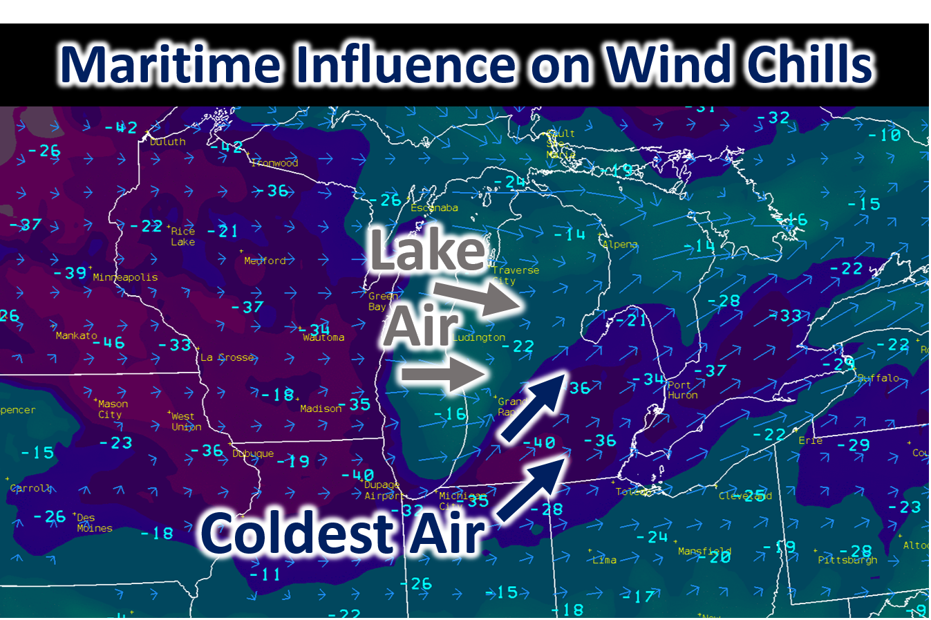 |
Wind Chills (shaded and values) and wind (arrows) valid at ~11 PM EDT 1/30/2019.
Check out the lists of coldest 2-day temperatures and wind chills across Lower Michigan:
|
2-Day Coldest Wind Chills ...ALLEGAN COUNTY... WAYLAND -33 F 0939 PM 01/30 2 WNW BRADLEY -31 F 0819 PM 01/30 WAYLAND -29 F 0610 PM 01/30 3 E ALLEGAN -29 F 0800 PM 01/30 1 ESE NORTH DORR -28 F 0559 PM 01/30 FENNVILLE -27 F 0610 AM 01/30 W MICH REGIONAL ARPT -26 F 0800 AM 01/30 ALLEGAN -26 F 0540 PM 01/30 FENNVILLE - AG MESONET -23 F 0900 AM 01/30 2 W FENNVILLE -23 F 0900 AM 01/30 ...BARRY COUNTY... PIERCE CEDAR CREEK INSTITUTE -30 F 0600 AM 01/31 2 WNW DOWLING -29 F 0900 AM 01/31 ...CALHOUN COUNTY... 2 WNW BROWNLEE PARK -42 F 0814 AM 01/31 W K KELLOGG AIRPORT -40 F 0353 PM 01/30 MARSHALL BROOKS FIELD -37 F 1116 PM 01/30 CALHOUN COUNTY ROAD COMMISSI -34 F 1000 PM 01/30 5 WSW CERESCO -34 F 1000 PM 01/30 AG MESONET - ALBION -31 F 0800 PM 01/30 1 NW ALBION -31 F 0800 PM 01/30 1 E BROWNLEE PARK -30 F 1050 PM 01/30 ...CLARE COUNTY... 2 SW LEOTA -24 F 0612 AM 01/31 ...CLINTON COUNTY... CAPITAL CITY AIRPORT -38 F 0653 PM 01/30 1 N HASLETT -26 F 0801 PM 01/30 ...EATON COUNTY... CHARLOTTE FITCH BEACH ARPT -38 F 0736 AM 01/31 OLIVET -35 F 0649 AM 01/31 2 W WAVERLY -28 F 0658 PM 01/30 CHARLOTTE - WINDSWEPT FARMS -23 F 0900 AM 01/30 1 WNW GRESHAM -23 F 0900 AM 01/30 ...GRATIOT COUNTY... WHEELER -35 F 0818 AM 01/31 ITHACA AG MESONET - PIONEER/ -33 F 1200 AM 01/31 6 ENE ITHACA -33 F 1200 AM 01/31 GRATIOT COMMUNITY AIRPORT -30 F 0915 AM 01/31 SAINT LOUIS -29 F 0804 AM 01/31 1 W PERRINTON -26 F 0643 PM 01/30 ...INGHAM COUNTY... 3 NE HOLT -35 F 0900 PM 01/30 MSU DEPT. OF HORTICULTURE TE -35 F 0900 PM 01/30 MASON JEWETT ARPT -34 F 0716 PM 01/30 HANCOCK TURFGRASS RESEARCH C -32 F 0900 PM 01/30 LESLIE - LAVERN ELDRED FARM -32 F 0600 PM 01/30 1 SSE EAST LANSING -32 F 0900 PM 01/30 2 NW LESLIE -32 F 0600 PM 01/30 2 SSW EAST LANSING -25 F 0801 PM 01/30 ...IONIA COUNTY... IONIA COUNTY ARPT -34 F 0606 PM 01/30 CLARKSVILLE AG MESONET -30 F 0600 PM 01/30 2 NNW CLARKSVILLE -30 F 0600 PM 01/30 BELDING AG MESONET -29 F 0900 PM 01/30 3 ENE GRATTAN -29 F 0900 PM 01/30 ...ISABELLA COUNTY... 1 SSE MOUNT PLEASANT -30 F 0905 AM 01/30 MT PLEASANT MUNI ARPT -26 F 0956 AM 01/30 MOUNT PLEASANT -25 F 0855 AM 01/30 4 SSE SHEPHERD -25 F 1135 PM 01/30 ...JACKSON COUNTY... 2 WNW JACKSON -42 F 1030 PM 01/30 LEONI -40 F 0900 PM 01/30 JACKSON COUNTY-REYNOLDS FIEL -40 F 0956 PM 01/30 1 WNW JACKSON -35 F 1059 PM 01/30 1 ESE SANDSTONE -30 F 1117 PM 01/30 ...KALAMAZOO COUNTY... KZOO/BATTLE CREEK INTL AIRPO -40 F 0853 AM 01/31 FULTON -37 F 0924 AM 01/31 1 ENE COMSTOCK -34 F 0814 AM 01/31 KALAMAZOO NATURE CENTER - MA -31 F 0600 PM 01/30 2 SE COOPER -31 F 0600 PM 01/30 ...KENT COUNTY... GERALD R FORD INTL -31 F 0653 PM 01/30 2 ESE COMSTOCK PARK -26 F 0620 AM 01/30 2 WNW KENTWOOD -25 F 0745 AM 01/30 2 SE CEDAR SPRINGS -22 F 0932 PM 01/30 KENT CITY - MAWN -21 F 0900 AM 01/30 1 ENE CASNOVIA -21 F 0900 AM 01/30 2 E WRIGHT -21 F 0600 AM 01/30 SPARTA AG MESONET -21 F 0600 AM 01/30 WALKER -19 F 0846 AM 01/30 2 N CANNONSBURG -19 F 0847 AM 01/30 1 SSW ADA -18 F 1030 AM 01/31 2 ENE BELMONT -17 F 0803 AM 01/30 1 ESE WALKER -17 F 0801 AM 01/30 1 WSW GRANDVILLE -15 F 0801 AM 01/30 2 SW EAST GRAND RAPIDS -15 F 0702 AM 01/30 2 S GRAND RAPIDS -15 F 0331 PM 01/30 ...LAKE COUNTY... 1 S BALDWIN -21 F 0738 AM 01/30 ...MASON COUNTY... BIG SABLE POINT -26 F 0330 AM 01/30 MASON CO APT -25 F 0616 AM 01/30 LUDINGTON -25 F 0530 AM 01/30 2 W SCOTTVILLE -24 F 0602 AM 01/30 3 SSE LUDINGTON -22 F 0615 AM 01/30 LUDINGTON -22 F 0600 AM 01/30 4 SE LUDINGTON -22 F 0600 AM 01/30 ...MECOSTA COUNTY... MECOSTA - SACKETT FARMS - MA -29 F 0900 AM 01/30 1 NNE SYLVESTER -29 F 0900 AM 01/30 BIG RAPIDS ROBEN-HOOD ARPT -25 F 0755 AM 01/30 ...MONTCALM COUNTY... 1 W ENTRICAN -29 F 1200 AM 01/31 ENTRICAN -28 F 1200 AM 01/31 STANTON -23 F 0940 PM 01/30 ...MUSKEGON COUNTY... MUSKEGON GLERL -30 F 0540 AM 01/30 WHITE RIVER LIGHTHOUSE -26 F 0746 AM 01/30 MUSKEGON COUNTY AIRPORT -26 F 0638 AM 01/30 1 NNW RAVENNA -26 F 0705 AM 01/30 NORTON SHORES -23 F 0615 AM 01/30 1 WSW NORTON SHORES -23 F 0717 AM 01/30 WOLF LAKE -21 F 0704 AM 01/30 1 ENE NORTON SHORES -19 F 0515 AM 01/30 1 WSW NORTON SHORES -17 F 0530 AM 01/30 ...NEWAYGO COUNTY... FREMONT MUNICIPAL ARPT -28 F 0635 AM 01/30 REEMAN -28 F 0635 AM 01/30 FREMONT -26 F 0825 AM 01/30 FREMONT -24 F 0824 AM 01/30 WHITE CLOUD -22 F 0836 AM 01/30 1 S NEWAYGO -16 F 0658 AM 01/30 ...OCEANA COUNTY... 4 SSE HART -32 F 0535 AM 01/30 PENTWATER -25 F 0530 AM 01/30 HART AG MESONET -24 F 0600 AM 01/30 1 WSW WEARE -24 F 0600 AM 01/30 4 SSE HART -21 F 1216 AM 01/30 3 ENE PENTWATER -20 F 0630 AM 01/30 ...OSCEOLA COUNTY... 1 E EVART -29 F 0813 AM 01/30 1 NW REED CITY -26 F 0817 AM 01/30 2 SE HERSEY -24 F 0919 AM 01/30 ...OTTAWA COUNTY... HOLLAND HARBOR -26 F 1000 AM 01/30 2 SSW JAMESTOWN -23 F 0705 PM 01/30 1 NW GRAND HAVEN -23 F 0500 AM 01/30 2 NNE MACATAWA -23 F 0519 AM 01/30 1 NNE JAMESTOWN -20 F 0811 AM 01/30 HUDSONVILLE -18 F 1045 PM 01/30 HUDSONVILLE -18 F 0300 PM 01/30 1 WSW HUDSONVILLE -18 F 0300 PM 01/30 3 N OLIVE CENTER -18 F 0900 AM 01/30 WEST OLIVE AG MESONET - NORT -18 F 0900 AM 01/30 ...VAN BUREN COUNTY... LAWTON -35 F 1200 PM 01/30 1 E LAWTON -34 F 0801 AM 01/31 LAWTON - OXLEY FARMS - MAWN -34 F 0900 AM 01/31 3 W PAW PAW -34 F 0900 AM 01/31 LAWRENCE - MANDIGO FARMS - -34 F 0900 AM 01/31 HARTFORD -32 F 0200 PM 01/30 1 NNE HARTFORD -32 F 0300 PM 01/30 2 WSW GOBLES -30 F 0220 PM 01/30 SOUTH HAVEN RGNL ARPT -26 F 0816 PM 01/30 1 W GRAND JUNCTION -19 F 0900 AM 01/30 GRAND JUNCTION -19 F 0900 AM 01/30 ...MARITIME STATIONS... SOUTH HAVEN GLERL -30 F 0920 AM 01/30
_______________________________
Broken or Tied Records:
A RECORD FOR THE COLDEST HIGH TEMPERATURE (LOW MAXIMUM) ON JANUARY
30 WAS SET KALAMAZOO, MI. THE HIGH TEMPERATURE ONLY REACHED -1
DEGREES, BREAKING THE RECORD OF 5 DEGREES IN 1899. THIS WAS ONLY
THE FIFTH TIME A HIGH TEMPERATURE BELOW ZERO WAS RECORDED AT
KALAMAZOO AND THE FIRST SINCE JANUARY 19 1994.

THE RECORD FOR THE COLDEST HIGH TEMPERATURE (LOW MAXIMUM) WAS TIED
on JANUARY 31st IN GRAND RAPIDS, MI. THE HIGH TEMPERATURE FOR THE
CALENDAR DAY ONLY REACHED 4 DEGREES. THIS TIED THE PREVIOUS RECORD
OF 4 SET IN 1971.

A RECORD LOW TEMPERATURE (MINIMUM) FOR JANUARY 30 WAS SET AT
KALAMAZOO, MI. THE LOW TEMPERATURE OF -15 DEGREES BROKE THE PREVIOUS
RECORD OF -13 DEGREES IN 1951.

A RECORD LOW TEMPERATURE (MINIMUM) FOR JANUARY 31 WAS SET AT
KALAMAZOO, MI. THE LOW TEMPERATURE OF -18 DEGREES BROKE THE PREVIOUS
RECORD OF -15 DEGREES IN 1899.
A RECORD LOW TEMPERATURE (MINIMUM) OF -14 DEGREES WAS TIED AT LANSING MI on 1/31. THE OLD RECORD WAS -14 SET IN 1899. |
2-Day Coldest Air Temperatures ...ALLEGAN COUNTY... 1 NW PLAINWELL -17 F 0900 AM 01/31 WAYLAND -15 F 0849 AM 01/31 WAYLAND -14 F 0810 AM 01/31 ALLEGAN -13 F 0830 AM 01/31 2 WNW BRADLEY -12 F 0900 AM 01/31 3 E ALLEGAN -12 F 0800 AM 01/31 1 ESE NORTH DORR -10 F 0914 AM 01/31 FENNVILLE -7 F 0905 AM 01/31 FENNVILLE - AG MESONET -6 F 0800 AM 01/30 2 W FENNVILLE -5 F 0900 AM 01/30 W MICH REGIONAL ARPT -4 F 0816 AM 01/30 SAUGATUCK -3 F 0823 AM 01/30 ...BARRY COUNTY... 2 WNW DOWLING -17 F 0600 AM 01/31 PIERCE CEDAR CREEK INSTITUTE -17 F 0800 AM 01/31 HASTINGS -16 F 0700 AM 01/31 ...CALHOUN COUNTY... 2 WNW BROWNLEE PARK -20 F 0844 AM 01/31 AG MESONET - ALBION -18 F 0900 AM 01/31 1 E BROWNLEE PARK -18 F 0820 AM 01/31 W K KELLOGG AIRPORT -18 F 1253 PM 01/31 CALHOUN COUNTY ROAD COMMISSI -18 F 0900 AM 01/31 1 NW ALBION -18 F 0900 AM 01/31 5 WSW CERESCO -18 F 0900 AM 01/31 1 E SPRINGFIELD -17 F 0700 AM 01/31 MARSHALL BROOKS FIELD -17 F 1255 PM 01/31 ...CLARE COUNTY... 2 SW LEOTA -21 F 0812 AM 01/31 HARRISON -9 F 0700 AM 01/31 ...CLINTON COUNTY... CAPITAL CITY AIRPORT -14 F 1253 PM 01/31 2 SSE SAINT JOHNS -14 F 1000 PM 01/30 1 N HASLETT -13 F 1216 AM 01/31 ...EATON COUNTY... OLIVET -19 F 0824 AM 01/31 CHARLOTTE - WINDSWEPT FARMS -17 F 0800 AM 01/31 CHARLOTTE FITCH BEACH ARPT -16 F 1256 PM 01/31 1 WNW GRESHAM -16 F 0900 AM 01/31 EATON RAPIDS -14 F 0800 AM 01/31 1 NNW DIMONDALE -14 F 0800 AM 01/31 2 W WAVERLY -13 F 0853 AM 01/31 ...GRATIOT COUNTY... GRATIOT COMMUNITY AIRPORT -14 F 1255 PM 01/31 ITHACA AG MESONET - PIONEER/ -14 F 0900 AM 01/31 ITHACA -14 F 0800 AM 01/31 6 ENE ITHACA -14 F 0900 AM 01/31 SAINT LOUIS -14 F 0814 AM 01/31 WHEELER -12 F 0853 AM 01/31 1 W PERRINTON -12 F 0843 AM 01/31 ...INGHAM COUNTY... LESLIE - LAVERN ELDRED FARM -16 F 0900 AM 01/31 2 NW LESLIE -16 F 0900 AM 01/31 2 W OKEMOS -15 F 0832 AM 01/31 HANCOCK TURFGRASS RESEARCH C -15 F 0800 AM 01/31 3 NE HOLT -15 F 0900 AM 01/31 MSU DEPT. OF HORTICULTURE TE -15 F 0900 AM 01/31 1 SSE EAST LANSING -14 F 0900 AM 01/31 1 SSW MASON -14 F 0700 AM 01/31 1 WNW WEBBERVILLE -14 F 0800 AM 01/31 MASON JEWETT ARPT -14 F 1255 PM 01/31 2 SSW EAST LANSING -11 F 0830 AM 01/31 ...IONIA COUNTY... CLARKSVILLE AG MESONET -15 F 0900 AM 01/31 2 NNW CLARKSVILLE -15 F 0300 AM 01/31 IONIA COUNTY ARPT -15 F 0746 AM 01/31 BELDING AG MESONET -12 F 0900 AM 01/31 3 ENE GRATTAN -12 F 0900 AM 01/31 BELDING -11 F 0901 AM 01/31 ...ISABELLA COUNTY... 4 SSE SHEPHERD -15 F 0745 AM 01/31 MOUNT PLEASANT -13 F 0755 AM 01/31 1 SSE MOUNT PLEASANT -13 F 0815 AM 01/31 MT PLEASANT MUNI ARPT -12 F 1255 PM 01/31 1 NE MOUNT PLEASANT -12 F 0900 AM 01/31 ...JACKSON COUNTY... LEONI -21 F 0820 AM 01/31 1 WNW JACKSON -17 F 0810 AM 01/31 1 ESE SANDSTONE -16 F 0815 AM 01/31 JACKSON COUNTY-REYNOLDS FIEL -16 F 1256 PM 01/31 3 NNE JACKSON -16 F 0800 AM 01/31 2 WNW JACKSON -15 F 0830 AM 01/31 2 WNW LEONI -14 F 0837 AM 01/31 ...KALAMAZOO COUNTY... FULTON -21 F 0820 AM 01/31 KZOO/BATTLE CREEK INTL AIRPO -18 F 1253 PM 01/31 KALAMAZOO NATURE CENTER - MA -18 F 0700 AM 01/31 2 NW OSHTEMO -18 F 0900 AM 01/31 2 SE COOPER -17 F 0900 AM 01/31 3 ENE PORTAGE -17 F 0900 AM 01/31 1 ENE COMSTOCK -16 F 0849 AM 01/31 ...KENT COUNTY... 1 E BYRON CENTER -13 F 0939 AM 01/31 2 WNW KENTWOOD -11 F 0805 AM 01/31 NWS FORECAST OFFICE GRAND RA -11 F 0700 AM 01/31 2 SE CEDAR SPRINGS -10 F 1132 PM 01/30 1 SSW ADA -10 F 0925 AM 01/31 2 N CANNONSBURG -10 F 0902 AM 01/31 GERALD R FORD INTL -10 F 1253 PM 01/31 2 ESE COMSTOCK PARK -10 F 0824 AM 01/31 2 NW GRAND RAPIDS -9 F 1000 AM 01/31 WALKER -8 F 0846 AM 01/31 2 SW EAST GRAND RAPIDS -8 F 0701 AM 01/31 KENT CITY - MAWN -8 F 0900 AM 01/30 1 ENE CASNOVIA -8 F 0900 AM 01/30 2 E WRIGHT -8 F 1200 AM 01/31 SPARTA AG MESONET -8 F 1200 AM 01/31 2 ENE BELMONT -7 F 0853 AM 01/31 1 WSW GRANDVILLE -6 F 0932 PM 01/30 1 ESE WALKER -5 F 0831 AM 01/31 GRANDVILLE -5 F 0910 PM 01/30 2 S GRAND RAPIDS -5 F 0816 AM 01/31 ...LAKE COUNTY... 1 S BALDWIN -8 F 0738 AM 01/30 ...MASON COUNTY... LUDINGTON -6 F 0606 AM 01/30 LUDINGTON -6 F 0700 AM 01/30 4 SE LUDINGTON -6 F 0600 AM 01/30 MASON CO APT -5 F 0556 AM 01/30 2 W SCOTTVILLE -5 F 0632 AM 01/30 3 SSE LUDINGTON -4 F 0700 AM 01/30 LUDINGTON -4 F 0624 AM 01/30 BIG SABLE POINT -3 F 0400 AM 01/30 5 NNE LUDINGTON -2 F 0847 AM 01/31 ...MECOSTA COUNTY... BIG RAPIDS WATER WORKS -19 F 0700 AM 01/31 MECOSTA - SACKETT FARMS - MA -14 F 0800 AM 01/31 1 NNE SYLVESTER -13 F 0900 AM 01/31 BIG RAPIDS ROBEN-HOOD ARPT -12 F 0655 AM 01/31 ...MONTCALM COUNTY... ENTRICAN -16 F 0800 AM 01/31 STANTON -15 F 0830 AM 01/31 1 W ENTRICAN -14 F 0900 AM 01/31 ...MUSKEGON COUNTY... 1 NNW RAVENNA -8 F 0830 AM 01/30 WOLF LAKE -5 F 0759 AM 01/30 NORTON SHORES -4 F 0745 AM 01/30 CLOVERVILLE -4 F 0740 AM 01/30 MUSKEGON COUNTY AIRPORT -4 F 0724 AM 01/30 1 WSW NORTON SHORES -3 F 0747 AM 01/30 1 ENE ROOSEVELT PARK -3 F 0700 AM 01/30 MUSKEGON GLERL -3 F 0800 AM 01/30 1 WSW NORTON SHORES -2 F 0800 AM 01/30 WHITE RIVER LIGHTHOUSE -2 F 0630 AM 01/30 1 WSW NORTON SHORES -1 F 0957 AM 01/30 ...NEWAYGO COUNTY... 4 WSW FREMONT -10 F 0700 AM 01/31 FREMONT -9 F 0824 AM 01/30 WHITE CLOUD -8 F 0810 AM 01/30 1 S NEWAYGO -8 F 0433 AM 01/31 FREMONT -8 F 0845 AM 01/30 FREMONT - AG MESONET -7 F 0900 AM 01/30 2 S FREMONT -7 F 0900 AM 01/30 FREMONT MUNICIPAL ARPT -6 F 0835 AM 01/30 REEMAN -6 F 0835 AM 01/30 1 NNW WHITE CLOUD -6 F 0900 AM 01/30 ...OCEANA COUNTY... 4 SSE HART -8 F 0630 AM 01/30 4 SSE HART -6 F 0631 AM 01/30 HART AG MESONET -6 F 0700 AM 01/30 1 WSW WEARE -6 F 0600 AM 01/30 PENTWATER -4 F 0530 AM 01/30 3 ENE PENTWATER -4 F 0630 AM 01/30 HART -4 F 0700 AM 01/30 ...OSCEOLA COUNTY... 1 E EVART -24 F 0713 AM 01/31 2 SE HERSEY -19 F 0700 AM 01/31 ...OTTAWA COUNTY... 1 NNE JAMESTOWN -6 F 0901 AM 01/31 HUDSONVILLE -6 F 0805 PM 01/30 HUDSONVILLE -6 F 0800 PM 01/30 2 SSW JAMESTOWN -5 F 0945 AM 01/31 1 WSW HUDSONVILLE -5 F 1200 AM 01/31 WEST OLIVE AG MESONET - NORT -5 F 0800 AM 01/30 2 W NUNICA -4 F 0815 AM 01/30 GRAND HAVEN WWTP -4 F 0700 AM 01/30 2 NNE MACATAWA -4 F 0749 AM 01/30 2 ENE BEECHWOOD -4 F 0800 AM 01/30 1 N HUDSONVILLE -4 F 0800 AM 01/30 3 N OLIVE CENTER -4 F 0900 AM 01/30 1 NW GRAND HAVEN -3 F 0746 AM 01/30 3 SSE GRAND HAVEN -3 F 0900 AM 01/30 HOLLAND HARBOR -1 F 0748 AM 01/30 ...VAN BUREN COUNTY... LAWTON - OXLEY FARMS - MAWN -18 F 0800 AM 01/31 LAWTON -17 F 0900 AM 01/31 PAW PAW -17 F 0900 AM 01/31 3 W PAW PAW -17 F 0900 AM 01/31 LAWRENCE - MANDIGO FARMS - -17 F 0900 AM 01/31 2 WSW GOBLES -16 F 0755 AM 01/31 1 E LAWTON -16 F 0801 AM 01/31 HARTFORD -14 F 0800 AM 01/31 1 NNE HARTFORD -14 F 0800 AM 01/31 1 ENE GRAND JUNCTION -11 F 0831 AM 01/31 1 W GRAND JUNCTION -10 F 0900 AM 01/31 GRAND JUNCTION -10 F 0900 AM 01/31 1 ENE GRAND JUNCTION -8 F 0851 AM 01/31 SOUTH HAVEN RGNL ARPT -8 F 1256 PM 01/31 1 SSE SOUTH HAVEN -8 F 1100 AM 01/31 SOUTH HAVEN - DEGRANDCHAMPS -7 F 1100 AM 01/31 3 SSW SOUTH HAVEN -6 F 0900 PM 01/30 ...MARITIME STATIONS... SOUTH HAVEN GLERL -5 F 1120 AM 01/31 |
Accumulating Snow
From January 28th to early January 31st, parts of Lower Michigan experienced a nearly continuous period of snowfall and low visibility due to blowing snow. The snow started during the early morning hours of January 28th as a low pressure system swept through the Great Lakes. Much of Lower Michigan picked up 4 to 10" with a swath of higher amounts along and north of Highway 10. From January 29th to January 31st, lake effect snow from Lake Michigan swept across the area and at times reached as far as Lake Huron. The extremely cold temperatures were detrimental to snowflake growth, leading to snow flake sizes that were small and highly blow-able. Combined with persistent gusty winds, considerable blowing snow and a times white-out conditions were common. And, with much below freezing temperatures, snow removal effort became difficult. By January 31st, some parts of Lower Michigan tallied up as much as 2 feet of snow!
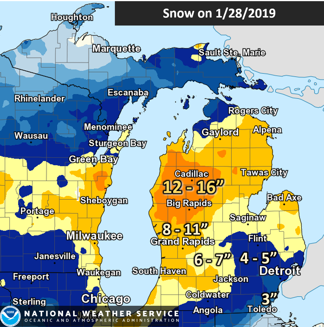
January 28th Snowstorm
A strong low pressure system swing through the Lower Great Lakes on January 27th and reached Lower Michigan on January 28th. Blizzard conditions were common from North Dakota to southern Wisconsin, with snow falling heavily in Lower Michigan on the 28th. Snowfall totals were generally from 4 to 10 inches with a stripe of higher amounts along and north of Highway 10.
Location Amount 2 E Walker 13.0 in Grandville 12.5 in 6 NW Scottville 12.4 in 1 WSW Grandville 12.2 in 1 E Walker 11.8 in Big Rapids Water Works 11.0 in 3 ESE Big Rapids 10.6 in Plainwell 10.6 in Bloomingdale 10.6 in Grandville 10.0 in Hastings 10.0 in Hopkins 1 N 9.4 in Ludington State Park 9.3 in 8 SW Skeels 9.2 in 1 W Ada 9.2 in 2 WNW Belmont 9.2 in 1 N East Grand Rapids 9.1 in Hart 8.7 in Mears 8.7 in 1 SSW Dutton 8.4 in 3 W Portage 8.3 in East Grand Rapids 8.3 in Holland 8.3 in Rockford 8.0 in 3 ESE Mount Pleasant 8.0 in 2 NW Sylvester 8.0 in 4 WSW Fremont 8.0 in 4 SSE Shepherd 7.7 in 2 NE Saranac 7.5 in 3 NW Palo 7.0 in 3 NNE Paw Paw 7.0 in 1 ESE Pulaski 6.6 in 1 N Haslett 6.2 in Western Michigan University 6.1 in Muskegon 4 SE 5.8 in Plainwell 5.4 E 5.7 in Nws Forecast Office Grand Ra 5.6 in Saint Johns 5.5 in Grand Ledge 5.1 in Saint Louis 5.1 in 4 SE Woodville 4.8 in 1 NE Paw Paw 4.3 in Alma 4.1 in |
|
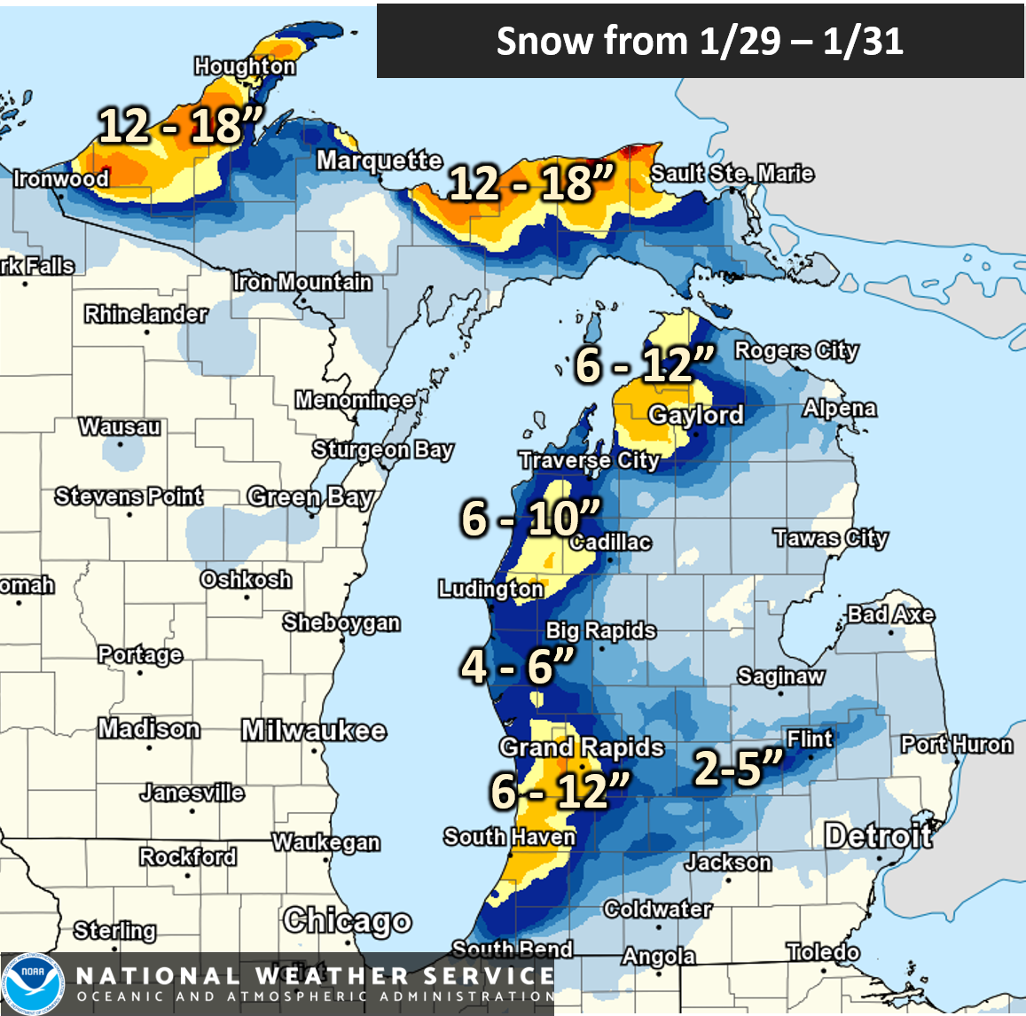
January 29 - 31st Lake Effect Snow
As the arctic air mass moved over the Midwest, lake effect snow increased over the eastern Lake Michigan shore and continued almost nonstop from January 29th to 31st. Normally a prolonged period of lake effect snow would lead to impressive snow totals, but the extremely cold air mass did not allow for efficient snowflake production. Nonetheless, the small snowflakes combined with gusty winds lead to a prolonged period of low visibility to near-blizzard conditions, especially along and west of US-131. The lake effect snow finally ended Thursday evening, leaving behind an additional 6 to 12 inches of snow, locally higher (especially in the U.P. of Michigan).
Location Amount CASTLE PARK 10.2 IN GRANDVILLE 13.0 IN 2 E WALKER 12.0 IN EAST GRAND RAPIDS 9.8 IN 2 W ZEELAND 9.0 IN NWS FORECAST OFFICE GRR 8.2 IN 2 WNW BELMONT 7.6 IN 1 SSW DUTTON 7.0 IN 4 WSW FREMONT 7.0 IN 6 NW SCOTTVILLE 6.8 IN PLAINWELL 6.6 IN 2 NW BEECHWOOD 6.5 IN 1 W ADA 6.4 IN MUSKEGON COUNTY AIRPORT 6.1 IN 1 NE PAW PAW 5.3 IN 3 NNE PAW PAW 5.0 IN 4 NNW DANSVILLE 5.2 IN HOPKINS 1 N 4.9 IN ROCKFORD 4.5 IN HASTINGS 3.5 IN LOWELL WWTP 3.4 IN 2 NE SARANAC 3.2 IN HART 2.6 IN PLAINWELL 5.4 E 2.4 IN ALMA 2.4 IN 1 N HASLETT 2.2 IN GRAND HAVEN WWTP 2.2 IN 3 W PORTAGE 2.0 IN EATON RAPIDS 1.4 IN 4 SE WOODVILLE 1.9 IN BIG RAPIDS WATER WORKS 1.7 IN 3 ESE BIG RAPIDS 1.2 IN 3 NNW STANWOOD 1.1 IN 2 NW SYLVESTER 1.0 IN 4 SSE SHEPHERD 1.0 IN |
|
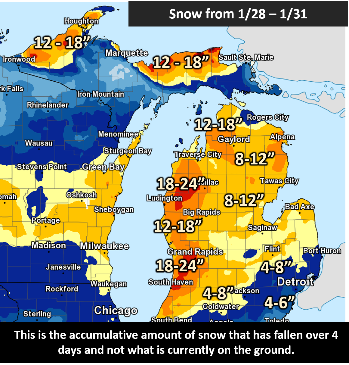
Total Snowfall Amounts from January 28th - 31st
Over a four-day period, total snow accumulations reached 12 to 18 inches across western Lower Michigan, with locations close to the Lake Michigan shoreline picking up nearly 2 feet! Note however that the map below shows the total accumulated snowfall over 4 days but not what was actually seen on the ground (snow settles when reaching the ground). The total *snow depth* went up to 12-18" in the hardest hit areas.
 |
Hazardous Travel
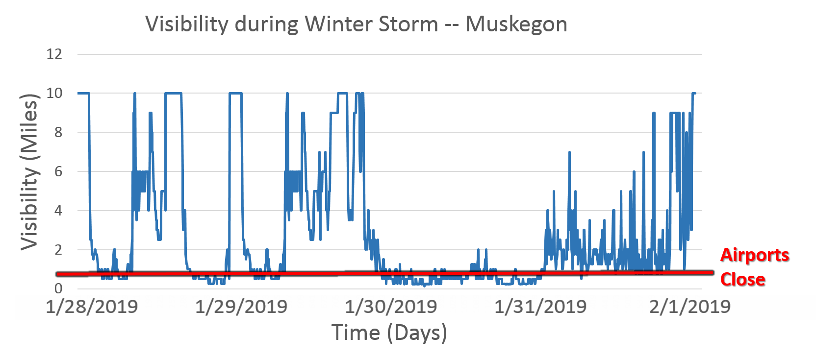
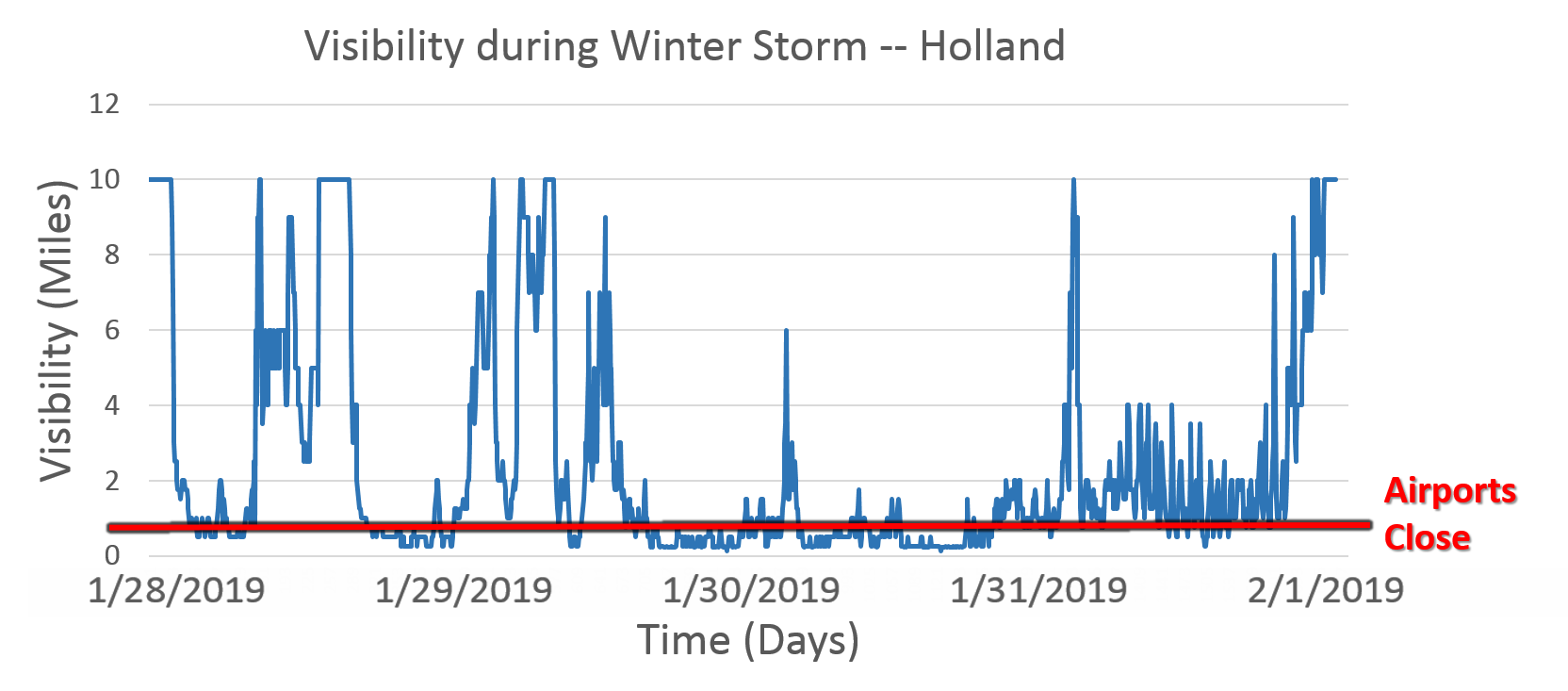
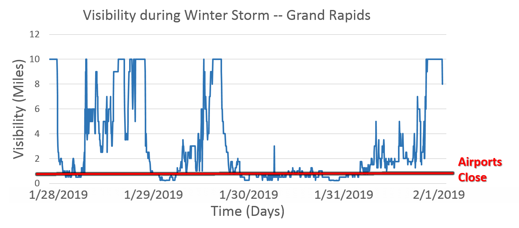
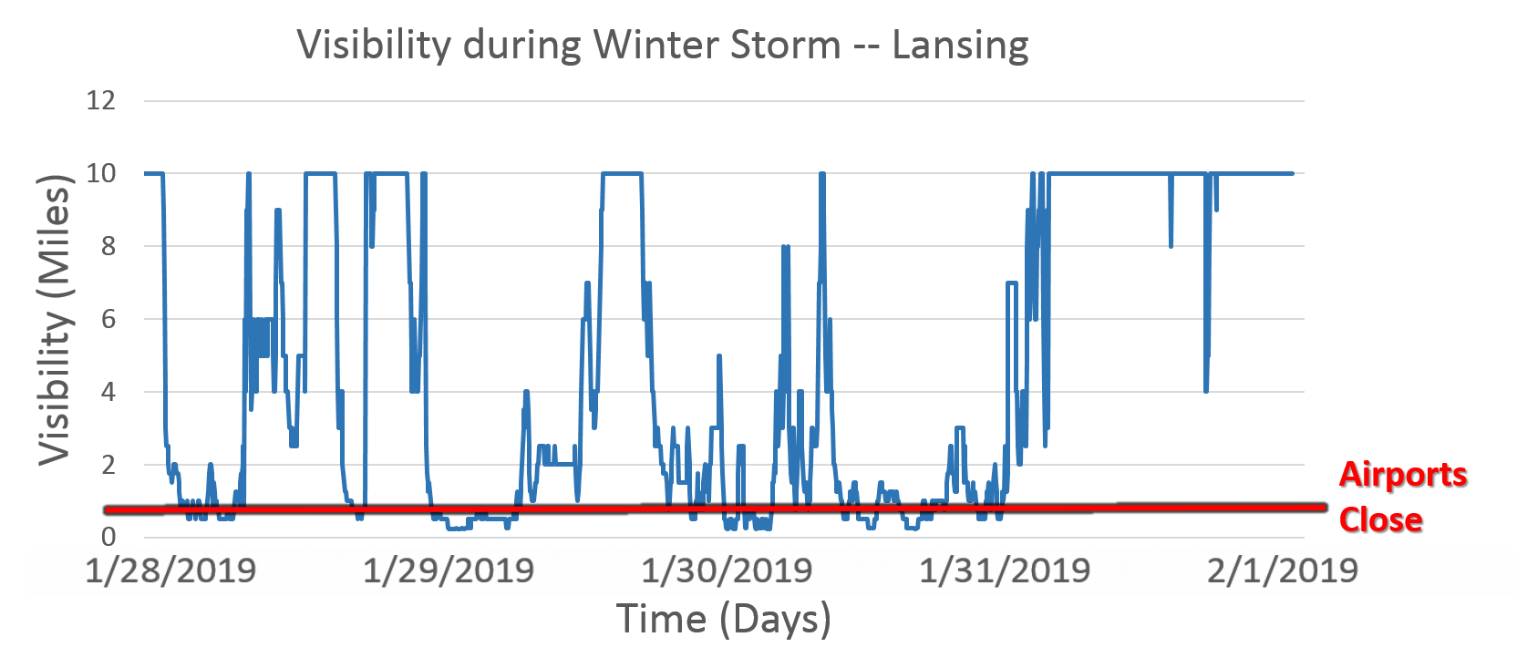
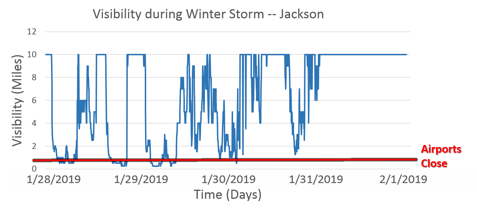
The combination of falling snow, gusty winds, and light snow led to considerable blowing snow restricting visibilities across Low Michigan for a prolonged period of time. In many areas, visibility was at or below 3 miles for days in a row, with extended periods of at or below 1/4 of a mile (the point at which airports close). Check out the plots below showing the visibility with time at Holland, Grand Rapids, Muskegon, Kalamzoo, Jackson, and Lansing.
 |
 |
 |
 |
 |
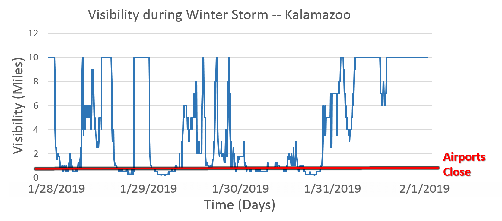 |
At the same time, temperatures were so cold that traditional snow removal efforts were difficult to impossible. Often times when a road was scraped or plowed, blowing snow would re-cover the roadway. Black ice also formed on many roadways, making what seemed like dry pavement actually even more dangerous. There were countless car accidents across Lower Michigan with several multi-car pile-ups on major interstates and highways. All in all, conditions became extremely dangerous for travel and served as a major impetus for closing area businesses and schools.
 |
Media use of NWS Web News Stories is encouraged! Please acknowledge the NWS as the source of any news information accessed from this site. |
|