Tropical Depression Two is expected to gradually strengthen and could bring tropical storm conditions to the Florida Panhandle beginning late Monday. Areas of flash flooding will be possible through Thursday along the eastern and central Gulf Coast. Severe thunderstorms will develop and move along a cold front crossing the Upper Midwest Monday, and through the Ohio Valley/Mid-Atlantic on Tuesday. Read More >
September 11th, 2019: High Winds Strike Greater Grand Rapids Area
|
|
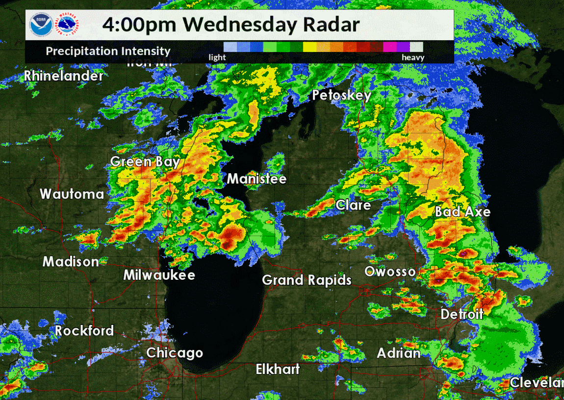
| Radar loop from 4:00 to 9:30 PM 9/11/2019. Note the line of storms that went through Grand Rapids, Michigan, where the most concentrated damage was reported. |
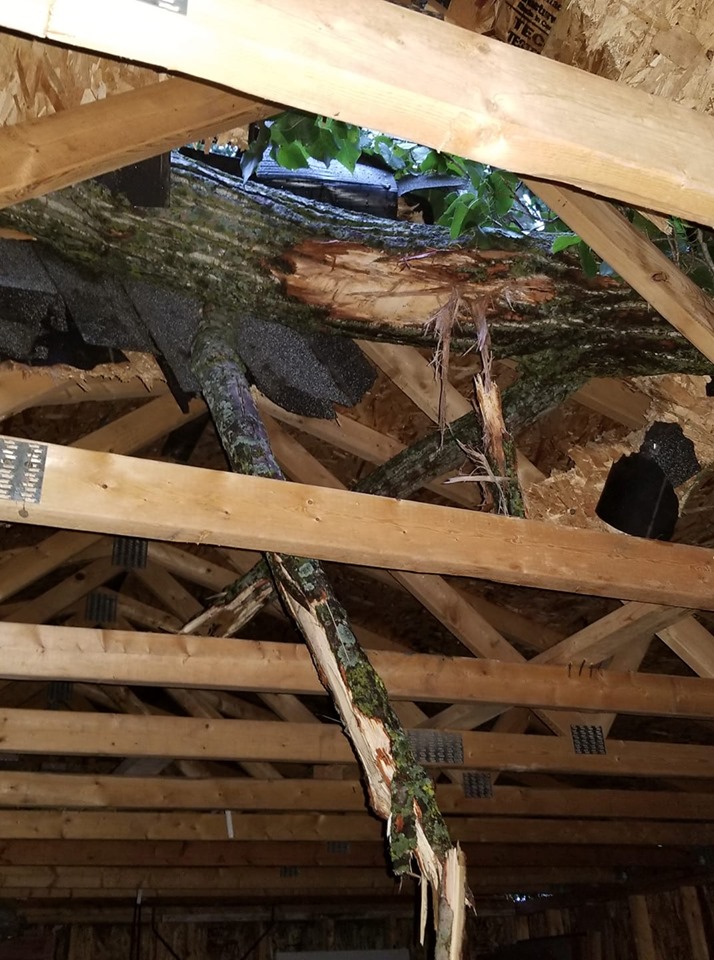
During the afternoon and evening hours of September 11th, strong to severe storms moved across western Lower Michigan. A ~50 mile swath of damage occurred from Walker to Lake Odessa with uprooted and snapped trees and numerous power outages due to estimated 65 to 80 MPH winds. A more concentrated area of damage was found in Grand Rapids especially east of US-131, where wind gusts locally approached 100 mph. Along the entire swath, there was little evidence lofted debris which would be typical of tornadoes, though brief swirls likely occurred in the swath.
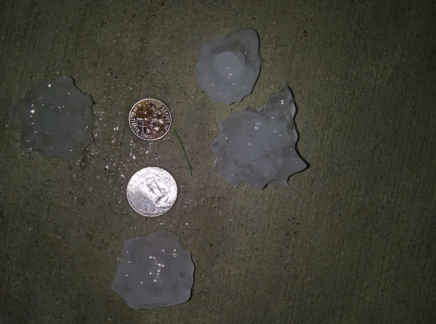
Earlier in the day, hail as large as ping pong balls (1.5" in diameter) and scattered wind damage was also reported, especially across Newaygo and Montcalm counties.
Finally, the storms provided much needed rainfall with swaths 1-2" across western Lower Michigan.
Swath of High Winds:
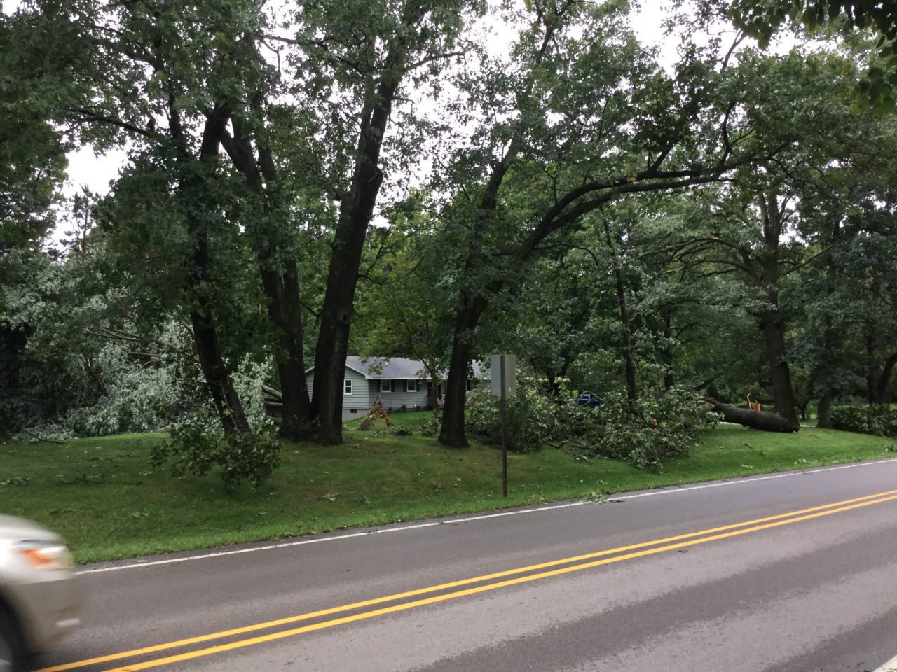
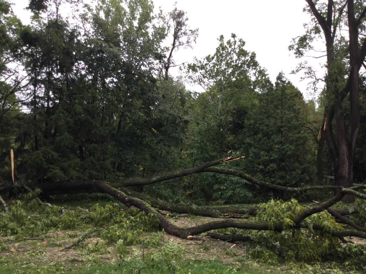
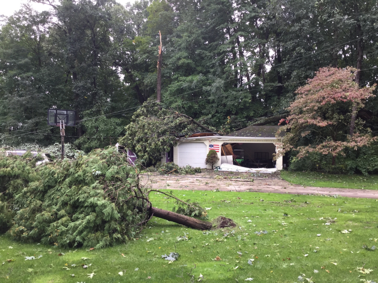
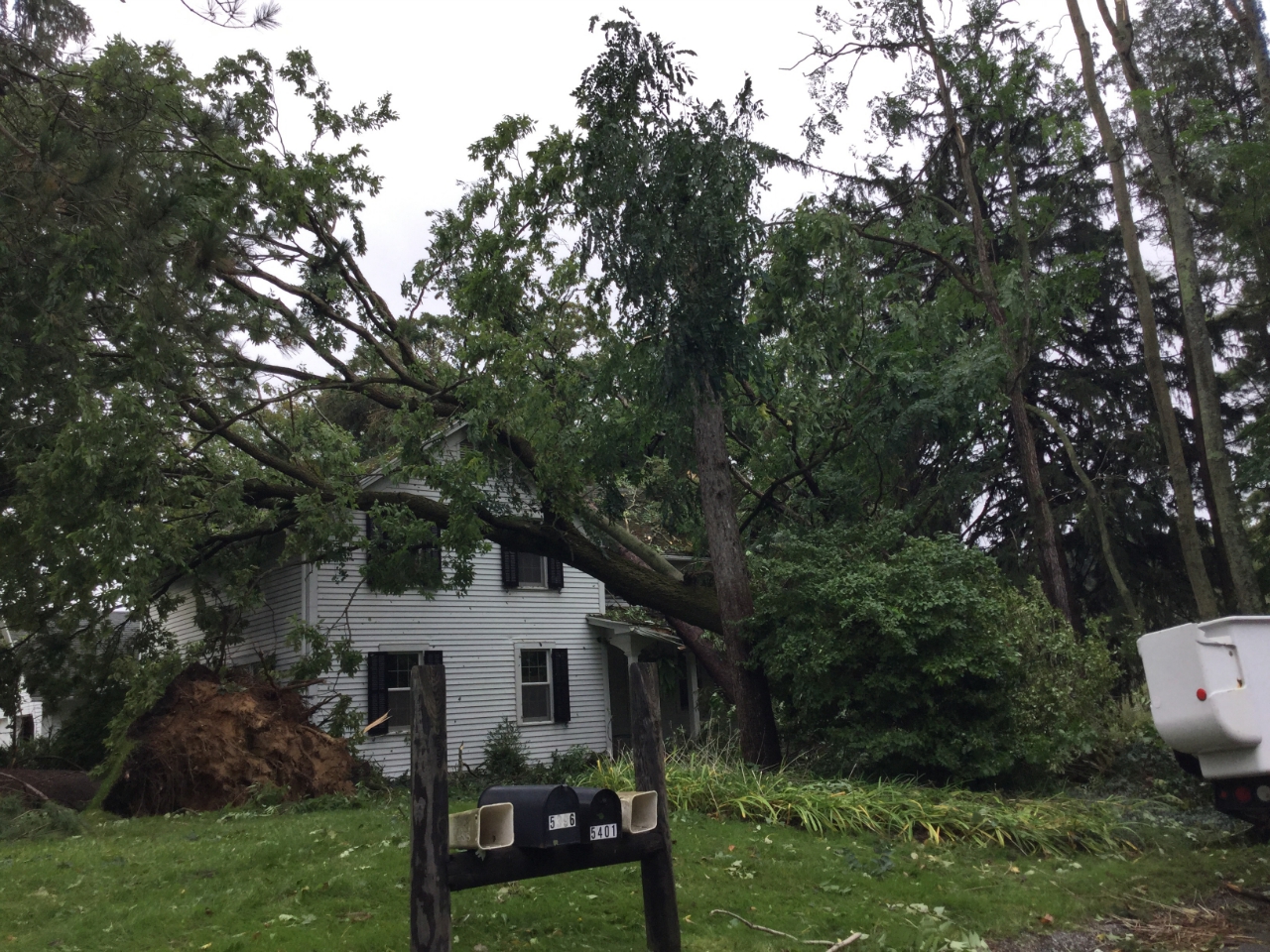
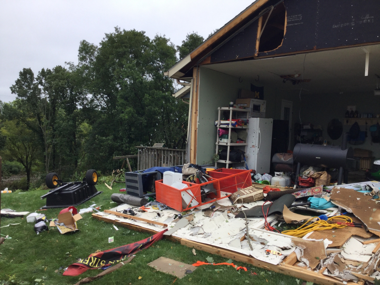
As a line of storms moved toward Grand Rapids, they intensified rapidly and produced a roughly 50 mile long swath of 65 to 80 mph winds from Marne to Sunfield. The north side of Grand Rapids was hit particularly hard where wind gusts likely approached 100 mph. The damage along the swath was immense, with trees snapped and uprooted and damage to buildings, especially in the Belknap Lookout neighborhood of north Grand Rapids.
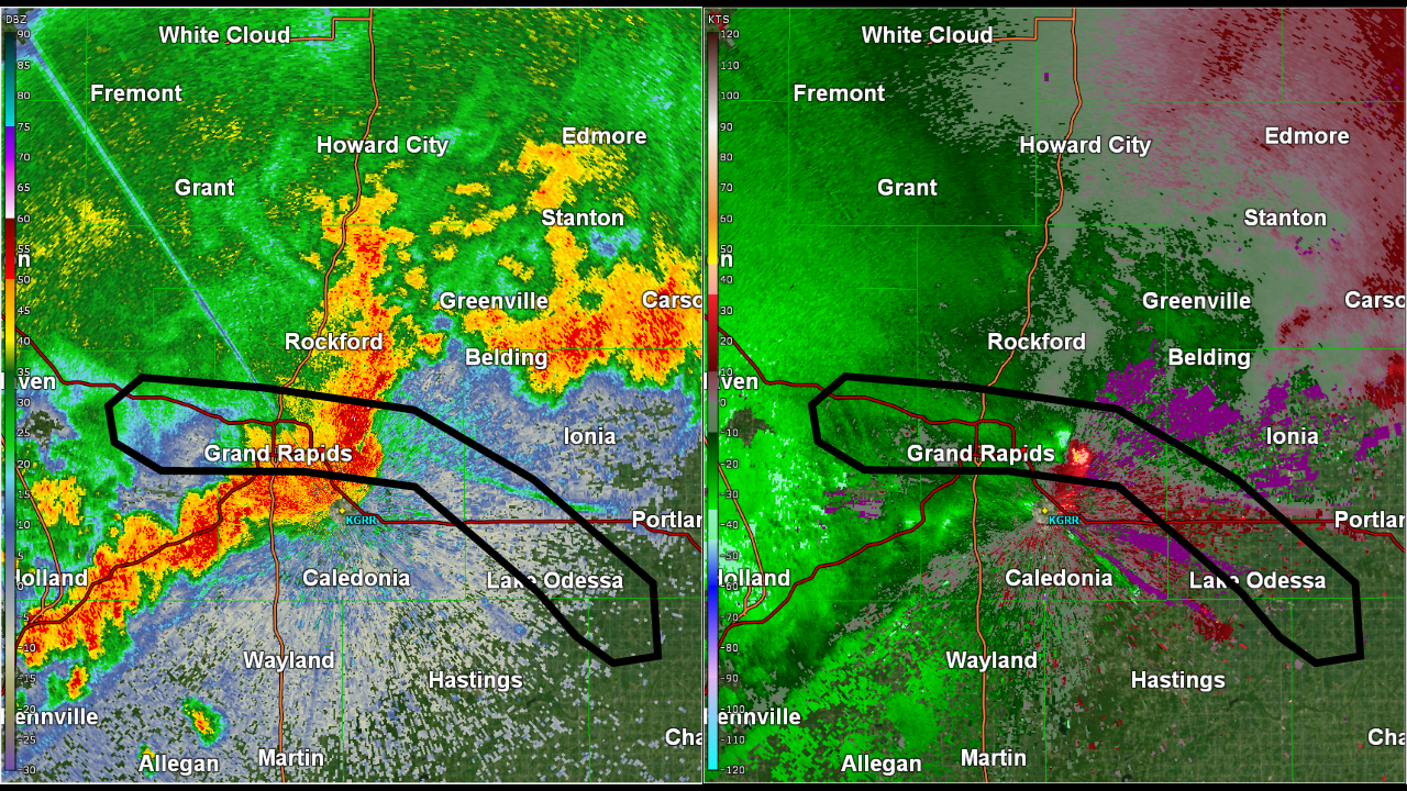 |
| Radar reflectivity (left) and radial velocity at 7:54 PM as the line of severe storms moved through the Grand Rapids area. The black line denotes the swath of the most intense damage. Note the fine green line on the left image ahead of the line of storms showing the location of an outflow boundary--this was key to identifying the location of where the strongest winds would occur with this storm. |
Two NWS Damage Survey teams combed through the damage to determine what occurred. The damage survey process includes looking at the damage from the ground, talking to those who witnessed the storm, and reviewing radar data. Oftentimes, the determination between tornadic and non-tornadic winds is not trivial, which was certainly the case with this storm.
|
Damaging Wind Swath
Track Map 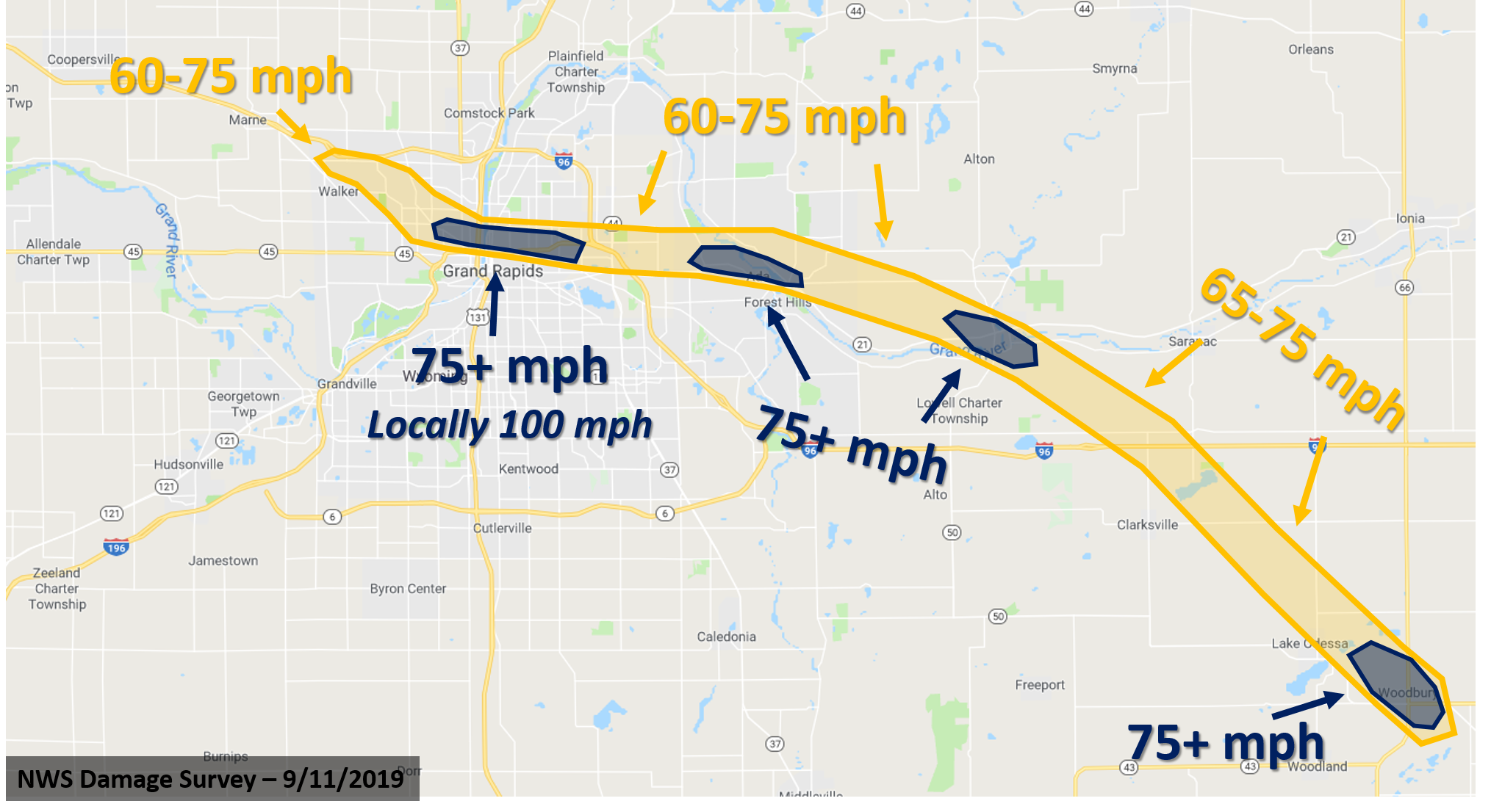 |
 |
 |
 |
 |
| Woodbury Township Area | Lake Odessa Area | Ada Township Area | Ada Township Area |
| NWS Damage Survey | NWS Damage Survey | NWS Damage Survey | NWS Damage Survey |
 |
 |
 |
 |
| Grand Rapids Township | Forest Hills Area | Grand Rapids Township Area | Grand Rapids |
| NWS Damage Survey | NWS Damage Survey | NWS Damage Survey | NWS Damage Survey |
 |
 |
 |
| Grand Rapids | Grand Rapids | Grand Rapids |
| NWS Damage Survey | NWS Damage Survey | NWS Damage Survey |
Newaygo, Montcalm, and Gratiot Counties:
Numerous thunderstorms moved over Newaygo, Montcalm, and Gratiot counties during the late afternoon hours producing large hail and damaging winds. The largest hail was reported near Stanton and Vestaburg, with concentrated wind damage near Vestaburg. Check out some of the photos below that were shared with us on social media.
 |
 |
| Hail that fell in Vestaburg - Courtesy of Adam Marshall relayed via WOODTV. | Hail that fell in Stanton - Courtesy of Jenn Treece relayed via WOODTV. |
 |
 |
| Wind damage from Vestaburg - Courtesy of Marlena DeHate Burggren | Wind damage from Vestaburg - Courtesy of Marlena DeHate Burggren |
Rainfall Reports:
24 Hour Precipitation Reports

...ALLEGAN COUNTY...
WAYLAND 2.0 W                1.29 IN   0715 AM 09/12   42.67N/85.68W
W MICH REGIONAL ARPT         1.28 IN   0753 AM 09/12   42.75N/86.10W
HOLLAND 4.1 WSW              1.27 IN   0700 AM 09/12   42.76N/86.18W
HOPKINS                      1.21 IN   0840 AM 09/12   42.64N/85.68W
NORTH DORR                   1.15 IN   0844 AM 09/12   42.76N/85.73W
HOPKINS 0.6 NNE              1.04 IN   0700 AM 09/12   42.63N/85.76W

...BARRY COUNTY...
MIDDLEVILLE                  1.77 IN   0842 AM 09/12   42.70N/85.40W
4 SSW HASTINGS               1.02 IN   0600 AM 09/12   42.59N/85.32W

...CALHOUN COUNTY...
BATTLE CREEK                 1.92 IN   0840 AM 09/12   42.32N/85.11W
MARSHALL                     1.55 IN   0800 AM 09/12   42.27N/84.97W
MARSHALL BROOKS FIELD        1.13 IN   0835 AM 09/12   42.23N/84.95W

...CLARE COUNTY...
HARRISON 5.2 ESE             1.60 IN   0700 AM 09/12   43.99N/84.70W
LEOTA                        1.28 IN   0812 AM 09/12   44.12N/84.92W

...CLINTON COUNTY...
DE WITT 1.2 W                1.48 IN   0700 AM 09/12   42.83N/84.60W
1 NW DEWITT                  1.09 IN   0700 AM 09/12   42.85N/84.58W

...EATON COUNTY...
EATON RAPIDS 6.6 N           1.30 IN   0723 AM 09/12   42.60N/84.67W
EATON RAPIDS                 1.17 IN   0800 AM 09/12   42.52N/84.65W

...GRATIOT COUNTY...
ITHACA AG MESONET            1.50 IN   0800 AM 09/12   43.32N/84.49W
MIDDLETON                    1.23 IN   0843 AM 09/12   43.19N/84.70W
...INGHAM COUNTY...
MASON 5.8 ENE                1.67 IN   0800 AM 09/12   42.61N/84.34W

...IONIA COUNTY...
SARANAC 2.6 NE               1.57 IN   0630 AM 09/12   42.96N/85.17W
BELDING 1.5 SSE              1.15 IN   0804 AM 09/12   43.07N/85.23W
SARANAC                      1.02 IN   0202 AM 09/12   42.96N/85.20W

...ISABELLA COUNTY...
MOUNT PLEASANT               1.68 IN   0845 AM 09/12   43.59N/84.77W
SHEPHERD                     1.37 IN   0840 AM 09/12   43.47N/84.67W

...JACKSON COUNTY...
JACKSON COUNTY-REYNOLDS FIEL 1.26 IN   0826 AM 09/12   42.27N/84.47W
JACKSON 1.2 ENE              1.19 IN   0800 AM 09/12   42.25N/84.38W

...KENT COUNTY...
LOWELL 5.5 NW                2.00 IN   0800 AM 09/12   42.99N/85.42W
WYOMING 1.7 NW               1.97 IN   0747 AM 09/12   42.91N/85.73W
1 E BYRON CENTER             1.78 IN   0844 AM 09/12   42.81N/85.70W
TRUFANT 1.8 SE               1.68 IN   0800 AM 09/12   43.29N/85.33W
EAST GRAND RAPIDS 0.7 SSW    1.66 IN   0700 AM 09/12   42.94N/85.61W
2 WNW KENTWOOD               1.58 IN   0845 AM 09/12   42.90N/85.63W
2 NNW CALEDONIA              1.43 IN   0600 AM 09/12   42.83N/85.53W
CALEDONIA 2 NE               1.38 IN   0700 AM 09/12   42.82N/85.48W
LOWELL 1.4 ESE               1.36 IN   0700 AM 09/12   42.92N/85.32W
ALTO 4.5 SW                  1.32 IN   0700 AM 09/12   42.82N/85.45W
CALEDONIA 4.4 WNW            1.22 IN   0620 AM 09/12   42.83N/85.59W
GERALD R FORD INTL           1.20 IN   0753 AM 09/12   42.88N/85.52W
GRAND RAPIDS 3.0 NW          1.04 IN   0645 AM 09/12   42.99N/85.69W
BELMONT 1.0 WNW              1.01 IN   0700 AM 09/12   43.08N/85.63W

...LAKE COUNTY...
BALDWIN                      1.36 IN   0838 AM 09/12   43.88N/85.85W

...MECOSTA COUNTY...
BIG RAPIDS 5.4 S             1.96 IN   0700 AM 09/12   43.63N/85.48W
LAKEVIEW 2.5 NNE             1.83 IN   0800 AM 09/12   43.48N/85.26W
BIG RAPIDS WATER WORKS       1.82 IN   0700 AM 09/12   43.70N/85.48W

...MONTCALM COUNTY...
FENWICK 3.3 E                2.70 IN   0700 AM 09/12   43.15N/85.01W
STANTON 5.0 ENE              1.63 IN   0700 AM 09/12   43.31N/84.99W

...MUSKEGON COUNTY...
WHITEHALL                    1.20 IN   0831 AM 09/12   43.37N/86.42W

...NEWAYGO COUNTY...
CROTON DAM                   2.55 IN   0800 AM 09/12   43.43N/85.67W
GRANT 4.8 NW                 1.96 IN   0700 AM 09/12   43.38N/85.88W
WHITE CLOUD 7.5 ENE          1.80 IN   0700 AM 09/12   43.61N/85.64W
FREMONT                      1.69 IN   0800 AM 09/12   43.42N/85.95W
FREMONT 4 WSW                1.52 IN   0700 AM 09/12   43.45N/86.03W
...OCEANA COUNTY...
HURON-MANISTEE EAST PORT     1.81 IN   0816 AM 09/12   43.51N/86.17W
HART                         1.32 IN   0700 AM 09/12   43.70N/86.37W
MONTAGUE 8.1 NW              1.07 IN   0700 AM 09/12   43.50N/86.47W

...OSCEOLA COUNTY...
EVART                        1.35 IN   0813 AM 09/12   43.90N/85.25W

...OTTAWA COUNTY...
ALLENDALE 1.7 SE             1.31 IN   0700 AM 09/12   42.97N/85.93W
HUDSONVILLE                  1.16 IN   0845 AM 09/12   42.87N/85.87W
HOLLAND                      1.10 IN   0700 AM 09/12   42.80N/86.12W
...VAN BUREN COUNTY...
DECATUR 7.0 WNW              1.39 IN   0700 AM 09/12   42.13N/86.11W
|
 |
Media use of NWS Web News Stories is encouraged! Please acknowledge the NWS as the source of any news information accessed from this site. |
|