
Heat expands across the Desert Southwest, Plains, Mississippi Valley and Midwest into Monday. Fire weather concerns continue for portions of the Intermountain West. Active monsoonal moisture fuels thunderstorms over the Southwest with possible flash flooding. Tropical cyclone Fausto in the Pacific, should weaken as it approaches Hawaii; Dangerous surf, swells and rip currents are expected. Read More >
July 20th, 2019 Severe Weather, Flooding, and Record Rainfall
 |
| Damage to a home in Jenison, Michigan after a line of severe storms moved through western Lower Michigan during the early morning hours of July 20th, 2019. |
During the early morning hours of July 20th, 2019, a line of severe storms raced southeast across Lower Michigan downing trees and power lines. Microbursts with winds estimated near 80 mph severely damaged a home in Jenison and snapped trees in Cascade, and numerous measured wind gusts of 60-70 mph were measured as the line went through Muskegon, Ottawa, and Kent counties. Around 150,000 people lost power due to the storms with over 50,000 people in Kent county, alone.
Additional thunderstorms developed after sunrise in Mason and Lake counties and remained stationary for several hours. Radar-estimated rainfall amounts ranged from 8 to 12 inches in the hardest-hit locations leading to widespread areal flooding and road closures. A new state record 24-hour rainfall was measured in Sheridan Township (Mason County) where 12.92 inches of rain fell due to the storms.
Several more rounds of storms rolled through Lower Michigan during the afternoon hours of the 20th, but only sparse reports of damage and additional power outages were received.
This weather event also impacted northern Wisconsin. Check out the news article created by NWS Green Bay!
Early Morning Damaging Winds
As the line of storms rolled through Lower Michigan, widespread wind gusts of 45 to 55 mph lead to downed tree limbs and blown-over lawn furniture. Stronger winds went through Muskegon, Kent, Ottawa, and Ionia counties with measured gusts from 60 to 70 mph. The hardest-hit areas were near Jenison where an NWS Damage Survey determined peak wind gusts broached 80 mph in a microburst, with a second microburst identified in Cascade where numerous trees were snapped. The NWS Grand Rapids office located near Gerald R. Ford International Airport experienced two wind gusts of 69 mph on the outer edge of the microburst that impacted Cascade.
Power Outages
The widespread nature to the strong to damaging winds in combination with frequent lightning strikes lead to numerous power outages across the state of Michigan. The line of storms was responsible for around 150,000 customer outages. Strong winds in the southern portion of the Upper Peninsula as well as damage from storms during the evening of 7/19 contributed to a total of ~250,000 customer outages statewide by sunrise of 7/20/2019.
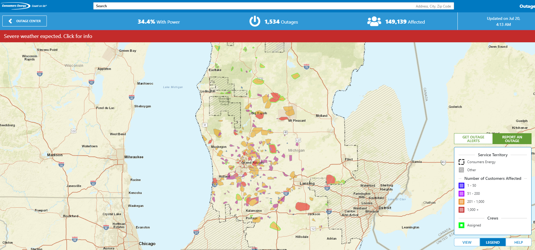 |
| Power Outage map "snapshot" at 4:00 AM showing nearly 150,000 customers without power after a line of severe storms moved through western Lower Michigan. Image courtesy of Consumers Energy. |
Jenison Damage Survey
Lines of storms can produce large areas of damaging winds. However, in intense lines of storms, embedded pockets of stronger winds called microbursts can lead to localized pockets of enhanced damage. Such was the case in Jenison, where wind gusts likely topped 80 mph. The winds were strong enough to knock in a garage door and lift the roof off of a home, uproot several trees, and make common objects air-born.
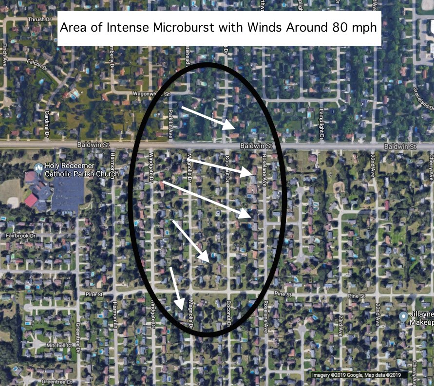 |
| Areal estimation of damage zone form a microburst in Jenison during the early morning hours of July 20th, 2019 based on an NWS Damage Survey. |
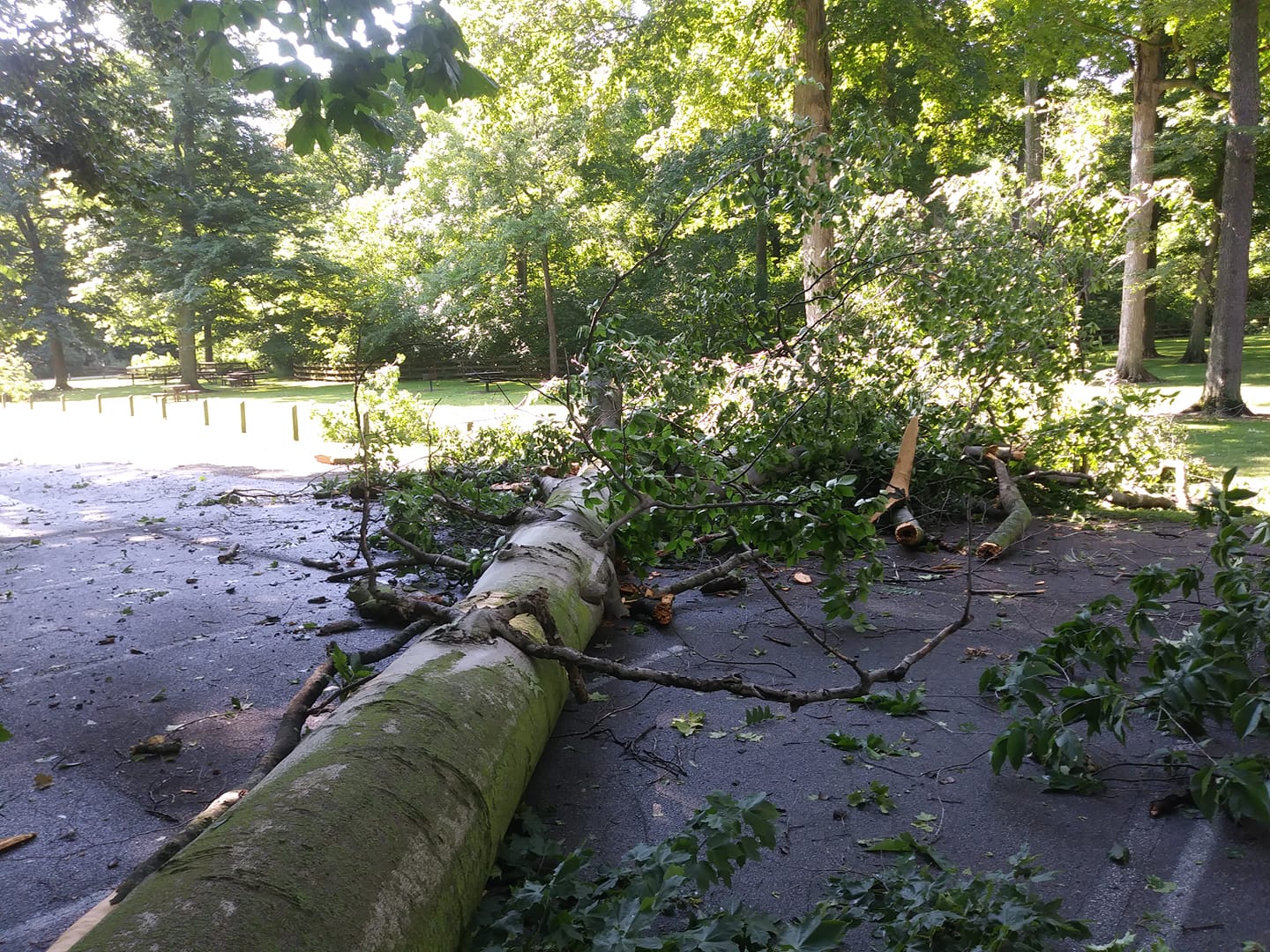
(Click on the images below to make them larger)
 |
|
 |
| Damage to a home in Jenison - NWS Damage Survey | Damage to a home in Jenison - NWS Damage Survey | Damage to a home in Jenison - NWS Damage Survey |
 |
 |
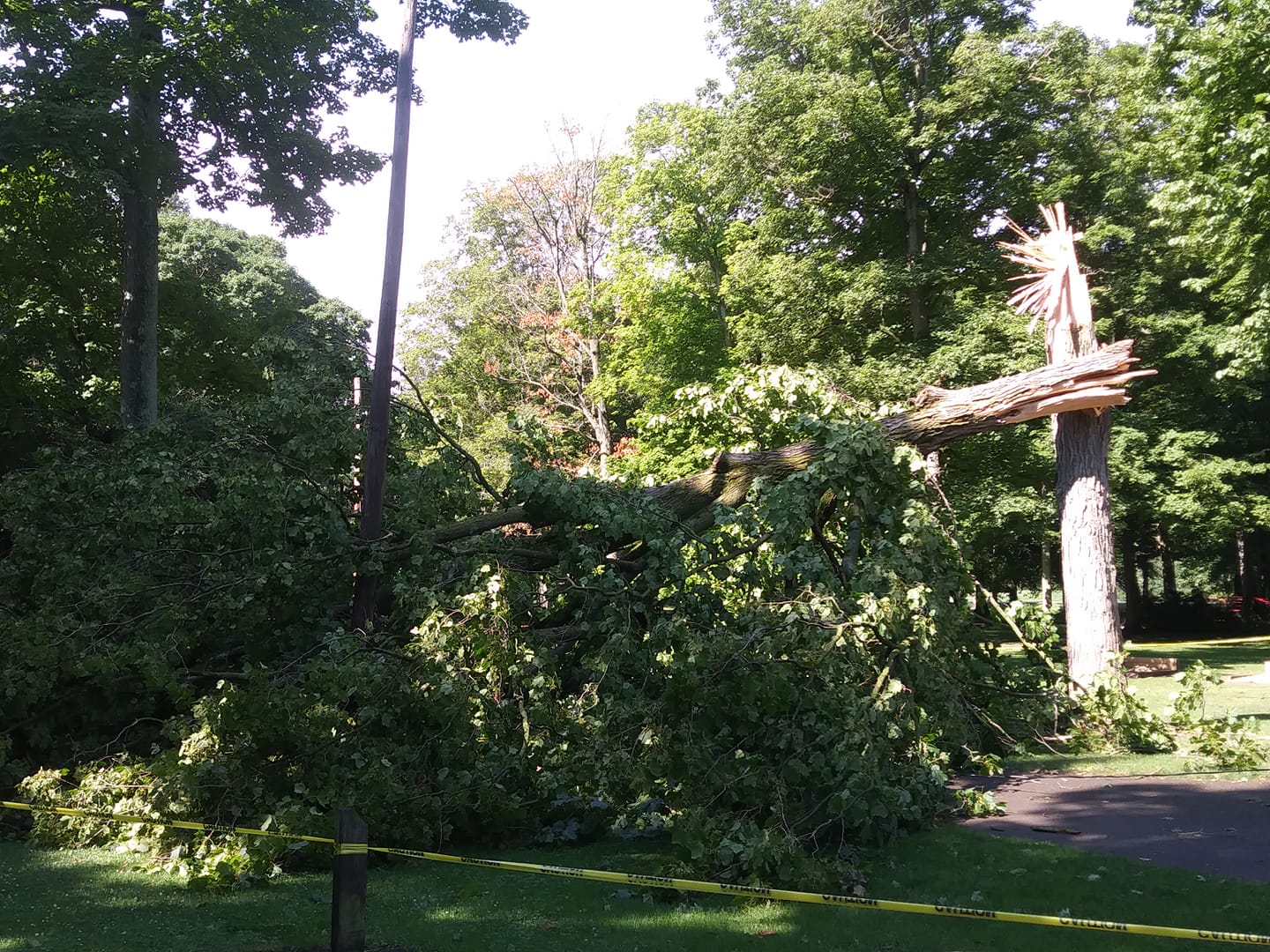 |
| Damage to a home due to a fallen tree in Jenison - NWS Damage Survey | Damage to trees in Hager Park in Jenison - Courtesy of Erik Buys | Damage to trees in Hager Park in Jenison - Courtesy of Erik Buys |
Highest Measured Wind Gusts:
Location                     Speed

        NWS Grand Rapids             69 MPH (twice)
Hudsonville                  67 MPH
Muskegon Airport             65 MPH
East Grand Rapids            61 MPH
Ludington                    58 MPH
Battle Creek                 58 MPH
Springfield                  56 MPH
Muskegon North Breakwater    51 MPH
8 NNW Ludington              49 MPH
Big Rapids                   48 MPH
1 SSE Reeman                 46 MPH
2 ENE Ludington              46 MPH
4 S Ionia                    46 MPH
1 NNW Big Rapids             45 MPH
|
Heavy Rain and Flooding:
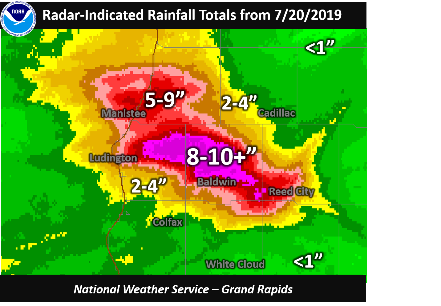
Behind the line of storms, thunderstorms developed over Lake Michigan and moved over a small portion of Lower Michigan for nearly 10 continuous hours. With such a moisture-rich atmosphere, heavy rainfall totals were achieved with a broad swath of 8-10" across Mason and Lake counties, with localized reports in excess of 12". The heavy rain lead to considerable areal flooding, road closures, and sinkholes especially in Mason and Lake counties. The highest reported rainfall was 12.92 inches by a mesonet rain gauge 6 miles east of Fountain in Mason County.
Rainfall Map and Reports
 |
|
Ten-hour rainfall totals across western Lower Michigan after nearly continuous thunderstorms during the morning of July 10th, 2019. |
Location                     Amount

 6 E Fountain                12.92 in*
1 NNE Custer                 9.50 in
Luther                       7.42 in
3 N Walhalla                 6.66 in
Chase                        6.40 in
8 NNE Ludington              6.04 in
8 SSE Irons                  6.00 in
6 N Ludington                5.63 in
1 E Chase                    4.59 in
Baldwin                      4.45 in
3 S Ashton                   4.00 in
Hersey                       3.37 in
2 SE Hersey                  3.24 in
3 N Walhalla                 2.60 in
6 N Ludington                2.51 in
1 NE Custer                  2.38 in
4 NW Montague                2.10 in
*State Record 24-Hour Rainfall |
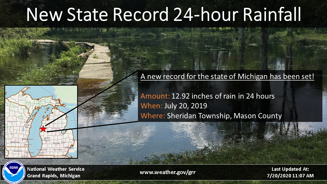
State Record 24-Hour Rainfall
The previous state record 24 hour rainfall was 9.78 inches measured in Bloomingdale on August 31, 1914. After the July 20th event, multiple reports of rainfall amounts greater than 10 inches were received. The National Weather Service in Grand Rapids investigated one such report report of 13.53 inches of rain received on July 20th, and visited the observer to performed a calibration on the automated rain gauge. A slight overcatch was noted and an adjustment factor was determined using a gauge calibration kit, resulting in a final value of 12.92 inches. The National Weather Service recommended that the state climate extremes committee review the proposed state record precipitation value of 12.92 inches. The Committee, which was comprised of five voting members representing local, state, and national climate experts, met on September 13th, 2019 and unanimously agreed to accept the 12.92 inches as the new state record 24 hour precipitation.
 |
|
Additional Information about the State Record 24 Hour Rainfall |
Fatalities Related to the Flooding
As the water worked its way through the rivers and into Lake Michigan, the outlet currents at the river mouths increased significantly. At the mouth of the Big Sable River near Ludington, multiple swimmers were swept out into deeper waters in Lake Michigan. Tragically, two swimmers drowned (July 22nd and July 25th) owing to the anomalously strong river mouth currents.
Damage Photos
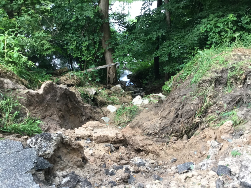
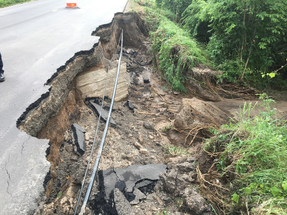
The National Weather Service in Grand Rapids surveyed the damage due to flooding with emergency management officials across Mason and Lake counties on July 23rd, 2019. The surveyors found washed-out roads, landslides, and evidence of high water marks on trees and power poles. A few photos taken during the survey are presented below.
(Click on the images below to make them larger)
 |
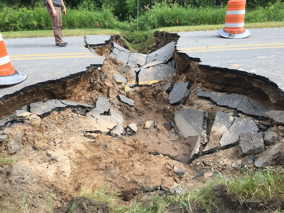 |
| Partial road collapse and landslide - NWS Damage Survey | Culvert failure and resultant road collapse - NWS Damage Survey |
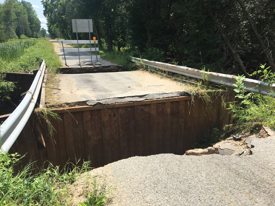 |
 |
| Partially collapsed bridge - NWS Damage Survey | Damaged road and culvert - NWS Damage Survey |
Radar Imagery:
Early Morning Damaging Winds:
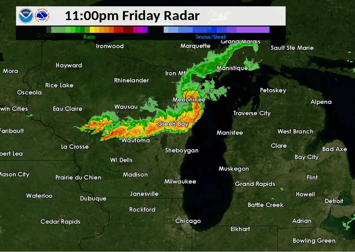 |
| Regional radar imagery from 11 PM 7/19 to 5 AM 7/20 showing the line of storms racing through western Lower Michigan. |
|
Radar imagery via KGRR from roughly 12:30 to 4:00 AM 7/20/2019 corresponding to when the line of storms was producing the most damage. Radar reflectivity (dBZ) and base velocity (kts) are shown on the left and right panels, respectively, with damage icons displaying as the line rolled through Lower Michigan. |
Heavy Rain and Flooding:
 |
|
Loop of radar reflectivity from ~5 AM to 3 PM July 20, 2019, focused on Mason and Lake counties in Lower Michigan. |
 |
Thank you to everyone who gave us permission to use their photos! Media use of NWS Web News Stories is encouraged! |
|
Page Last Updated: 9/25/2019

