
Tropical Depression Two is expected to gradually strengthen and could bring tropical storm conditions to the Florida Panhandle beginning late Monday. Areas of flash flooding will be possible through Thursday along the eastern and central Gulf Coast. Severe thunderstorms will develop and move along a cold front crossing the Upper Midwest Monday, and through the Ohio Valley/Mid-Atlantic on Tuesday. Read More >
Grand Junction, CO
Weather Forecast Office
Winter Storm Threat Increasing Next Week
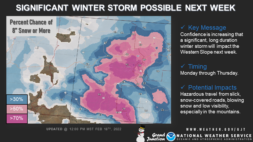
The potential for a significant winter storm next week is increasing across the Western Slope. A series of potent disturbances will result in a prolonged winter storm beginning on Monday and lasting through Wednesday night or Thursday. Potential impacts include hazardous travel from slick, snow-covered roads, blowing snow and low visibility. The mountains of western Colorado stand to face the greatest impacts, but adjacent valleys will also be at risk. Stay tuned to the forecast through the weekend and consider making alternate travel plans for next week.
Hazards
Detailed Hazards Viewer
National Briefing
Outlooks
Transportation Decision Support
Winter Storm Severity Index
Forecasts
Aviation Weather
Fire Weather
Forecast Discussion
Forecast Points
Local Area
Severe Weather
Soaring Forecast
Winter Weather
Hydrology
Recreational River Report
River Forecast
Weather Safety
Preparedness
NOAA Weather Radio
StormReady
SkyWarn
US Dept of Commerce
National Oceanic and Atmospheric Administration
National Weather Service
Grand Junction, CO
2844 Aviators Way
Grand Junction, CO 81506-8644
970-243-7007
Comments? Questions? Please Contact Us.

