
Tropical Depression Two is expected to gradually strengthen and could bring tropical storm conditions to the Florida Panhandle beginning late Monday. Areas of flash flooding will be possible through Thursday along the eastern and central Gulf Coast. Severe thunderstorms will develop and move along a cold front crossing the Upper Midwest Monday, and through the Ohio Valley/Mid-Atlantic on Tuesday. Read More >
Grand Junction, CO
Weather Forecast Office
Thanksgiving Climatology for Eastern Utah and Western Colorado
*Please note that 1919 brought an intense snowstorm to eastern Utah and western Colorado. However, some of our stations have not been around since 1919, so the "snowiest" Thanksgiving listed below is only since records were kept for those sites*
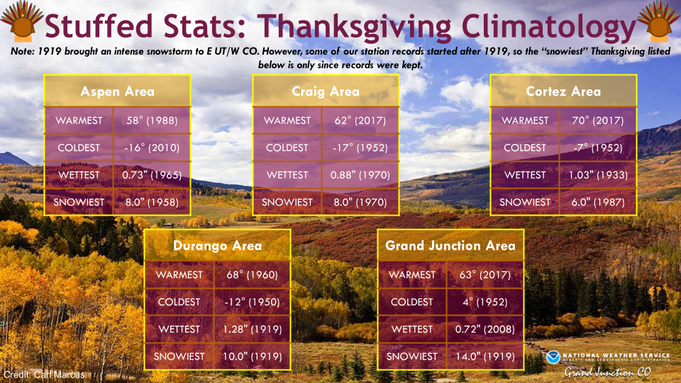
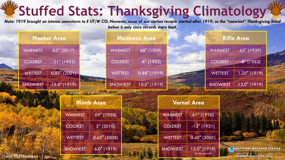
Let's take a look back at Thanksgivings past with some "Stuffed Stats" (aka Thanksgiving Climatology). By far the most impressive Thanksgiving took place on November 27, 1919 when an intense snowstorm dropped in from the northwest into eastern Utah and western Colorado. That storm produced record 24-hour snowfall totals for several of our climate sites including 14 inches in Grand Junction!
For more climate information from other sites, please visit our climate page on our website at https://www.weather.gov/wrh/climate?wfo=gjt. You can also follow us on Facebook (@NWSGrandJunction) or Twitter (@nwsgjt).
Hazards
Detailed Hazards Viewer
National Briefing
Outlooks
Transportation Decision Support
Winter Storm Severity Index
Forecasts
Aviation Weather
Fire Weather
Forecast Discussion
Forecast Points
Local Area
Severe Weather
Soaring Forecast
Winter Weather
Hydrology
Recreational River Report
River Forecast
Weather Safety
Preparedness
NOAA Weather Radio
StormReady
SkyWarn
US Dept of Commerce
National Oceanic and Atmospheric Administration
National Weather Service
Grand Junction, CO
2844 Aviators Way
Grand Junction, CO 81506-8644
970-243-7007
Comments? Questions? Please Contact Us.

