
Tropical Depression Two is expected to gradually strengthen and could bring tropical storm conditions to the Florida Panhandle beginning late Monday. Areas of flash flooding will be possible through Thursday along the eastern and central Gulf Coast. Severe thunderstorms will develop and move along a cold front crossing the Upper Midwest Monday, and through the Ohio Valley/Mid-Atlantic on Tuesday. Read More >
Grand Junction, CO
Weather Forecast Office
Spring Equinox Climatology for Eastern Utah and Western Colorado
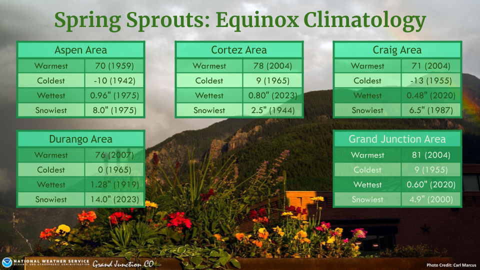
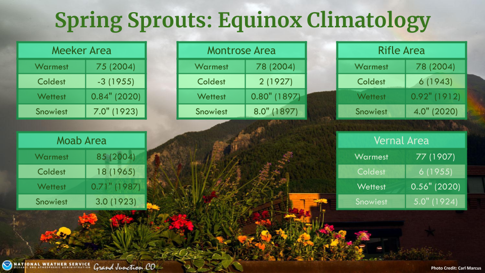
Let's take a look at some "Spring Spouts" (aka Spring Equinox Climatology) for selected cities across eastern Utah and western Colorado. The Equinox of 1923 must have felt more like winter than spring for the Meeker and Moab areas, where they received 7 and 3 inches of snow respectively. The lowest minimum temperature on the Spring Equinox thus far was -13F, which occurred in the Craig Area in 1955. The warmest Spring Equinox temperature was 85F, which occurred in the Moab Area in 2004. The wettest and snowiest Spring Equinox both occurred in the Durango Area. The wettest was in 1919, where 1.28 inches of liquid precipitation fell, and the snowiest was in 2023 when the area received up to 14 inches of snow.
For more climate information from other sites, please visit our climate page on our website at https://www.weather.gov/wrh/climate?wfo=gjt. You can also follow us on Facebook (@NWSGrandJunction) or X (@nwsgjt).
Hazards
Detailed Hazards Viewer
National Briefing
Outlooks
Transportation Decision Support
Winter Storm Severity Index
Forecasts
Aviation Weather
Fire Weather
Forecast Discussion
Forecast Points
Local Area
Severe Weather
Soaring Forecast
Winter Weather
Hydrology
Recreational River Report
River Forecast
Weather Safety
Preparedness
NOAA Weather Radio
StormReady
SkyWarn
US Dept of Commerce
National Oceanic and Atmospheric Administration
National Weather Service
Grand Junction, CO
2844 Aviators Way
Grand Junction, CO 81506-8644
970-243-7007
Comments? Questions? Please Contact Us.

