
Tropical Depression Two is expected to gradually strengthen and could bring tropical storm conditions to the Florida Panhandle beginning late Monday. Areas of flash flooding will be possible through Thursday along the eastern and central Gulf Coast. Severe thunderstorms will develop and move along a cold front crossing the Upper Midwest Monday, and through the Ohio Valley/Mid-Atlantic on Tuesday. Read More >
Grand Junction, CO
Weather Forecast Office
Easter Climatology for Eastern Utah and Western Colorado
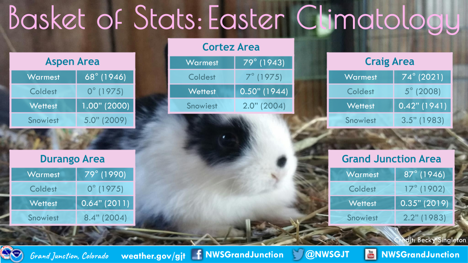
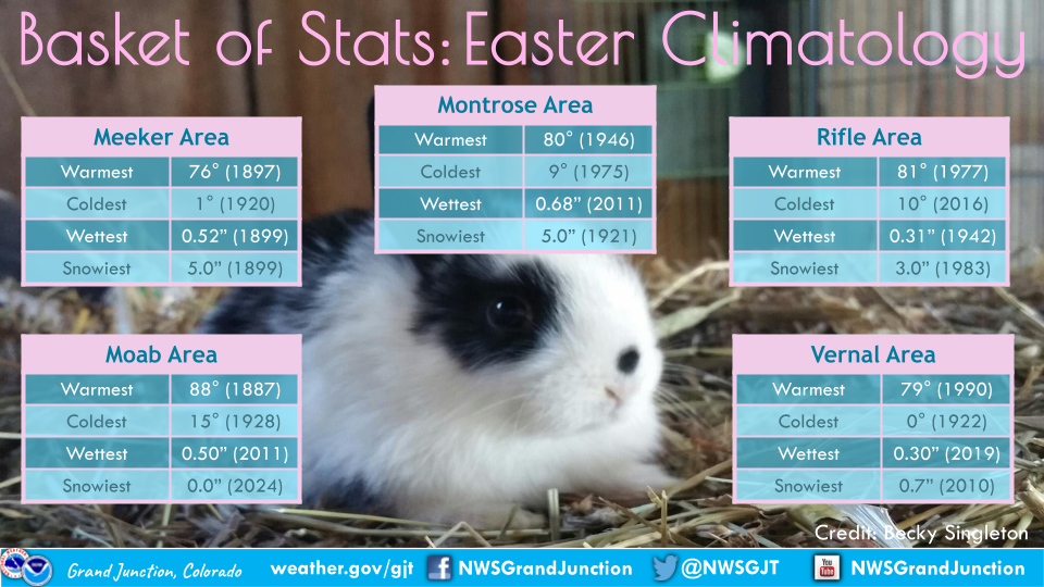
*Please note that all data mentioned is collected from our automated observing stations from 10 different airports across eastern Utah and western Colorado.*
The Spring season tends to be a wild ride most of the time with a mix of everything from snow to rain and hot to cold. That is evident in our Easter Climatology where some years have brought nearly 90-degree temperatures and others have ended with over 8 inches of snow!
For more climate information from other sites, please visit our climate page on our website at https://www.weather.gov/wrh/climate?wfo=gjt. You can also follow us on Facebook (@NWSGrandJunction) or X (@nwsgjt).
Hazards
Detailed Hazards Viewer
National Briefing
Outlooks
Transportation Decision Support
Winter Storm Severity Index
Forecasts
Aviation Weather
Fire Weather
Forecast Discussion
Forecast Points
Local Area
Severe Weather
Soaring Forecast
Winter Weather
Hydrology
Recreational River Report
River Forecast
Weather Safety
Preparedness
NOAA Weather Radio
StormReady
SkyWarn
US Dept of Commerce
National Oceanic and Atmospheric Administration
National Weather Service
Grand Junction, CO
2844 Aviators Way
Grand Junction, CO 81506-8644
970-243-7007
Comments? Questions? Please Contact Us.

