
Tropical Depression Two is expected to gradually strengthen and could bring tropical storm conditions to the Florida Panhandle beginning late Monday. Areas of flash flooding will be possible through Thursday along the eastern and central Gulf Coast. Severe thunderstorms will develop and move along a cold front crossing the Upper Midwest Monday, and through the Ohio Valley/Mid-Atlantic on Tuesday. Read More >
Grand Junction, CO
Weather Forecast Office
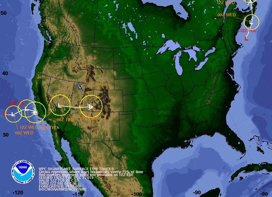
A Pacific storm off the southern California coast will move ashore Wednesday evening before tracking eastward across southern Nevada, southern Utah and onto the Four Corners region by Thursday morning. Though the arrival of the storm's center is a ways out, its impacts will be felt as early as Wednesday morning across southeast Utah and southwest Colorado as isolated to scattered light showers develop. A wintry mix of weather will spread north and eastward across the region as Wednesday progresses with the best chances for precipitation coming Wednesday night into Thursday morning as the storm moves to the Four Corners region. The latest model output suggests snowfall amounts of up to one foot are possible over portions of the San Juan Mountains and up to 8 inches across the La Sal, Abajo Mountains of southeast Utah and portions of the Uncompahgre Plateau and Grand Mesa in western Colorado. Conditions improve later on Thursday as the storm shifts to the southern Plains during the afternoon.
Storm Track
5 PM this evening to 5 AM Thursday 12/5
Total Snow Forecast
Tonight through 5 AM, December 6

Hazards
Detailed Hazards Viewer
National Briefing
Outlooks
Transportation Decision Support
Winter Storm Severity Index
Forecasts
Aviation Weather
Fire Weather
Forecast Discussion
Forecast Points
Local Area
Severe Weather
Soaring Forecast
Winter Weather
Hydrology
Recreational River Report
River Forecast
Weather Safety
Preparedness
NOAA Weather Radio
StormReady
SkyWarn
US Dept of Commerce
National Oceanic and Atmospheric Administration
National Weather Service
Grand Junction, CO
2844 Aviators Way
Grand Junction, CO 81506-8644
970-243-7007
Comments? Questions? Please Contact Us.

