Cold, Hot, Dry, Wet: 2014 Had it all for RGV Year in Review: Cool, Dry Start; Wet Finish Dry, Hot Summer Gives Way to Wet, Cooler Autumn that Turned Valley Lush |
|
 |
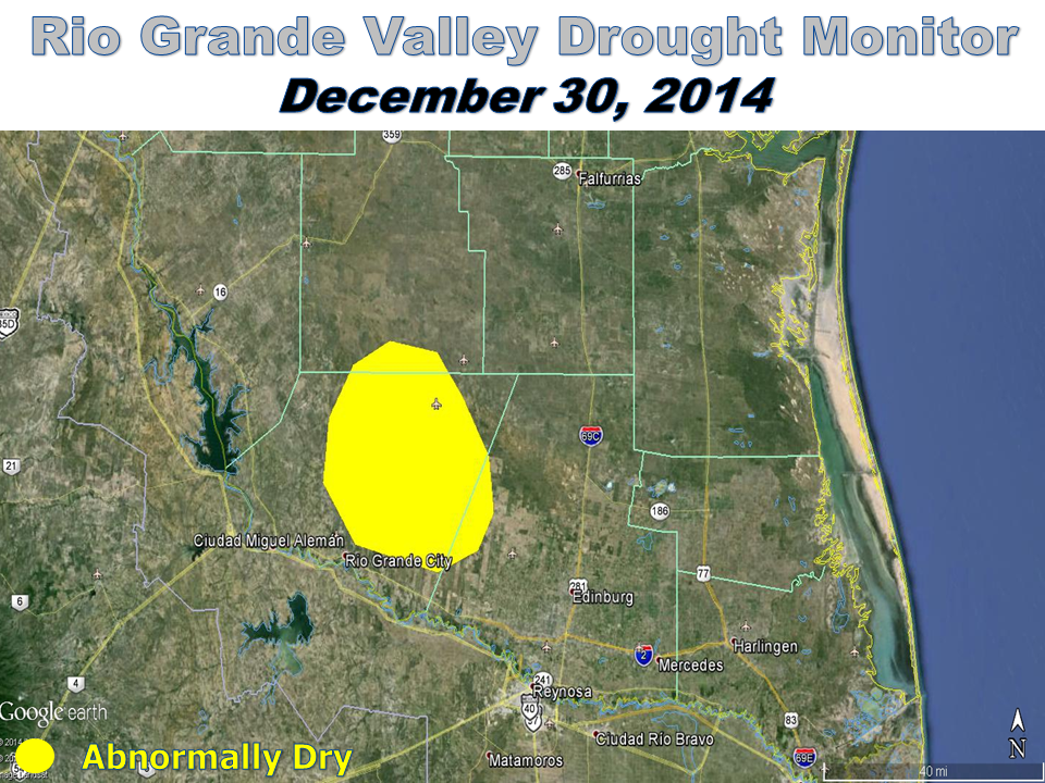 |
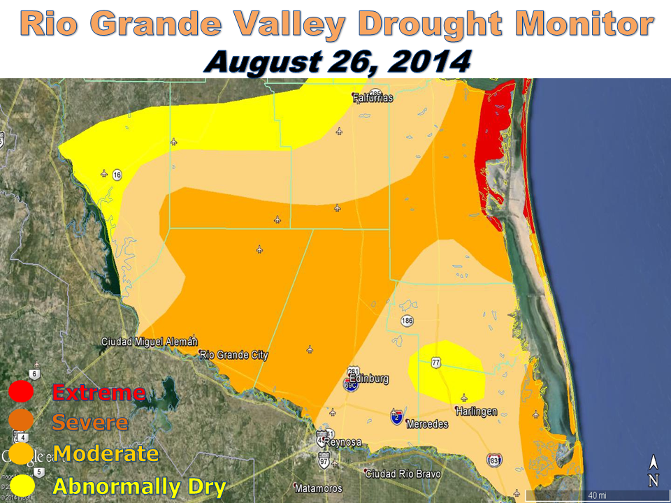
| Above: Drought monitor improvement from late August to the end of December 2014. Details on drought classification can be found here. | |
| July to September: 2013 Redux: Seasonable Heat Early Turns to Wetness Late | |
|
For a second summer in a row, July and August lived up to the generally hotter, and slightly drier, than average billing. While "La Canícula" prevailed most the time ("La Canícula" is most common between July 15 and August 15), periodic atmospheric disturbances punctuated the pattern with pockets of rainfall that only allowed a slow degradation of drought conditions. By the end of August (above, left), severe drought had expanded to cover much of the Upper Valley and portions of the central ranch lands, extending to the King Ranch. These conditions were much improved from the same time in 2013, when extreme to exceptional drought of late August, 2013. One of the aforementioned disturbances combined with a leftover surface boundary and the sea breeze to kick off a series of Mid Valley microbursts on August 13th, which destroyed poorly built mobile homes and blew down trees and power poles causing tens of thousands in property damage between Weslaco and Edinburg. Wet weather that arrived at summer’s end was a harbinger of September soakings to come, but not enough to change a dry and hot June through August – one that featured nearly 20 straight days of 100°F or higher afternoon temperatures in McAllen. September once again lived up to its billing as the wettest month on average across the Rio Grande Valley and Deep South Texas. The big rains that effectively eliminated the drought came without a direct strike from a tropical cyclone. Though no direct strike, the arrival of the outer bands from Tropical Storm Dolly on September 2nd and 3rd set the tone for the month, which would feature two more significant, widespread rain events. Rains from "Baby Dolly" turned the Valley green. Widespread rains of 3 to more than 6 inches, mainly on September 13th, brought widespread urban flooding and pockets of more than 3 feet of water to poor drainage areas in parts of Weslaco, Pharr, McAllen, and Mission. A final torrential band dropped another 2 to 4 inches in Greater Brownsville on the 15th, creating road closures and a mix of nuisance and flash flooding. By the 15th, Greater Brownsville had struck liquid gold, with between 10 and nearly 13 inches for the period. Even when the common pattern of deep east–southeast flow across South Texas was disrupted, along came a favorable upper level pattern from the southwest to close the month, and assist with pockets of torrential rain from Rio Grande City to Rio Hondo on the 26th and 27th. The result was more than six inches in Rio Grande City and more than 7 inches in northeast Cameron County, along with local flash flooding into some properties. More than fourteen inches fell from northeast Cameron to Greater Brownsville, as well as along and just west of U.S. 281 in Hidalgo County. |
|
| October to December: Temperatures Fall; Sunshine Turns Gray | |
|
The weather settled down in October for most of the Valley, with the sole exception of Cameron County, where two bouts of locally heavy rainfall mid–month kept the green going. A pocket of heavy rain from Brownsville northeast through the Laguna Madre in Willacy County dropped between 2 and 4 inches and caused some urban flooding between Brownsville and San Benito. A sunrise dump of 2 to 3 inches of rain over downtown Brownsville on the 22nd produced dangerous flash flooding in poor drainage locations downtown and on the west side, wreaking havoc on the morning commute and school transit. All Rio Grande Valley locations failed to see afternoon temperatures any lower than 80°F in October; the usual late month ’norther that brings pleasantly cool daytime temperatures never arrived. For Brownsville, the first sub–80°F day waited until November, one of a handful of years where the "endless summer" ended that late. Any talk of endless summer would be put to rest in November. A mild start was quickly undone by the fall season’s first "gray ’norther", which crashed daytime temperatures into the lower 60s. Upper level energy lifted tropical moisture over the cooler air, and welcome rainfall covered most of Deep South Texas, with 1 ½ to 3 inches common everywhere. Some of the higher rain totals covered northern Starr and southern Jim Hogg County, and finally eliminated the last of any drought category (moderate) from Deep South Texas. The four–day rainfall was two to three times the total monthly average. More would come before month’s end, but not until the Valley had a taste of winter between the 12th and 14th. The "Polar Express" arrived early, courtesy of atmospheric pattern buckling provided by a record strong cyclone in the Bering Sea between Alaska and Asia. Record low temperatures in the upper 30s joined stiff north winds, especially in the Lower Valley, to bring unusually chilly wind chill values in the mid to upper 20s on the 13th. In fact, the 24–hour change from November 11 to November 12 (noon to noon) in Harlingen was 37°F, a reminder of the seven occurrences during the 2013–2014 cool season. The unseasonable chill, which brought a four day period of more than 15°F below average temperatures, and was followed by a reinforcing shot on the 17th and 18th, ensured a top ten coldest finish, despite a brief warm up headed into the weekend before Thanksgiving. That weekend brought another round of rough weather, beginning with hail and damaging wind in Zapata and finishing with locally heavy rainfall from Weslaco to Harlingen on the 22nd. The Noisy November turned to a quiet December, which featured few extremes but plenty of mild to warm, humid, and often overcast weather. Light rainfall embedded with the clouds kept pace with the paltry average (a little over an inch) until the month’s closing act, which pushed totals above the long term average for most areas and marked at least a three of four month wet streak for the Lower Valley and parts of the Mid and Upper Valley. The prolonged warm and humid spell held overnight/early morning temperatures to levels seen in April, and fooled grasses and plants into growing like it was April. Rather than sleigh bells, lawn mowers were the sound of the season when dry air briefly arrived in time for Christmas. The final days of 2014 brought a resurgence of the "Gray ’norther", but the chill was not enough to reverse the warm outcome, with monthly temperatures averaging some 2 to 4° above the 1981–2010 benchmark. Deja Vu All Over Again? New Year’s Eve ended 2014 cold (40s, feels like 30s) and wet (a heavy mist), with a number of outdoor festivities moved indoors. |
|
| To Page 1 |
|

