Extremely critical fire weather concerns for portions of the southern High Plans as strong wind and very dry conditions could result in rapid spread of any fires. Meanwhile, severe thunderstorms are expected once again across areas of the Central and Southern Plains, then spreading in the Mississippi Valley regions on Monday. Damaging winds, very large hail and strong tornadoes are possible. Read More >
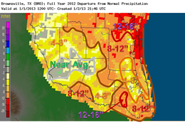
  Lower image: Departures from normal rainfall in 2012. Yellow, orange, and red colors denote departures below normal, defined as the 30 year cycle from 1981 to 2010. |
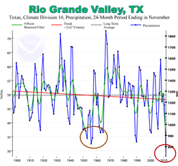
 Above: Average rainfall for 24 month cycles ending in November for Texas Climatological Division 10 (Hidalgo, Cameron, Willacy), back to 1900. Brown circle indicates period of 1950s and early 1960s drought. Red circle indicates current (2011/2012) drought, with the lowest 24 month precipitation (December 2010 to November 2012) on record, by far. |
| "Hail" of a Warm Year 2012: Record Warmth, Persistent Drought, and Memorable Thunderstorms Tropical Cyclones Steer Clear of the Rio Grande Valley |
|
| July to September: Scorching Heat, Little Rain (Again) | |
|
July and August were once again the perfect backdrop for many trips to the beach for Rio Grande Valley residents: Typically hot days, warm nights, and fresh breezes. Rainfall became scarce once again, with a few exceptions. Brownsville and points east had a lucky hit on July 13th and again on August 6th. Farther west, ranches from southern/central Jim Hogg County through western Starr County benefitted from slow moving thunderstorms during mid July. Meanwhile, the summer heat continued to build, and drought conditions began deteriorating once again. Moderate (level 1) to severe (level 2) drought at the beginning of July worsened to severe (level 2) to exceptional (level 4) drought by the end of August. At the end of summer, average temperatures landed in the top five hottest on record for most Rio Grande Valley residents; rainfall was equally sparse for all but a patch around Brownsville, and pockets along Highway 83 near the Roma (Starr County) bend northward through some of the ranchlands of Jim Hogg, Starr, and Zapata County. Click here for details. Typically wet September proved to be a mixed bag in 2012, but once again leaned toward the hot and dry side. With the exception of Rio Grande Plains, which was helped by remnant rains from Pacific Tropical Storm Norman, and pockets of the King Ranch in Kenedy and Brooks County, which got some fortunate rains from slow moving afternoon thunderstorms, monthly totals were generally 1 to 3 inches below average. By the end of September, the persistent high pressure ridge known as "La Canícula" had effectively shut down the Texas Gulf Coast Tropical Cyclone season. In short, significant drought relief would have to wait until 2013 – at least. |
|
| October to December: Summer Fades to...Spring? | |
|
October 2012 was better known as "Endless Summer". Persistent heat kept the fire burning, and despite the autumn’s first legitimate cold front just before Halloween, monthly temperatures finished among the top ten warmest at most Valley and Brush Country locations. Prior to the front, values were closing in on all time hottest levels, crystallized by a heat spike on October 18th ahead of an advancing trough which broke all–time records for the date, and for the month. Those temperatures, which reached as high as 108°F in La Joya, fueled a line of thunderstorms which quickly became nasty. Damaging hurricane force wind gusts, golf ball sized hail, and dangerous lightning hammered mainly rural Willacy and eastern Hidalgo County during the late afternoon. "Hot–tober", indeed! November kept the warm, dry theme going. Dry weather is expected as November ranks among the top three or four driest months of the year; with flattening high pressure holding firm from the Gulf occasionally back into northern Mexico, temperatures continued to rank among the top ten warmest. The only substantial rain occurred the Saturday evening after Thanksgiving, when a cold front eased across the Rio Grande Valley and brought welcome rains of more than an inch to Hidalgo and Starr counties as well as portions of the ranchlands in Jim Hogg and Brooks County. "April in December" aptly describes the final month of 2012, which finished the year on a high (temperature–wise) note. Average temperatures were more than five degrees above average across the Valley; at one point after Christmas Day, the values were still more than 7 degrees above average before a series of cold fronts kept readings down until New Year’s Eve. Once again, the monthly averages fell among the top ten warmest on record. An early month front was preceded by just enough instability to produce a small band of damaging wind and hail producing thunderstorms, which raced through Willacy and northern Cameron County around midnight on December 5th. The drought intensified further during the final two weeks of the month, with worsening conditions spreading west into the ranchlands of Starr, Jim Hogg, and Zapata County. Extremely dry fronts left 25 to 30 mph winds and relative humidity below 15 percent in their wake. Fortunately, no large wildfires were reported. New Year’s Eve finished the year appropriately: Warm, humid, and breezy, with temperatures in the 70s and lower 80s. To Page 1 |
|