National Weather Service United States Department of Commerce


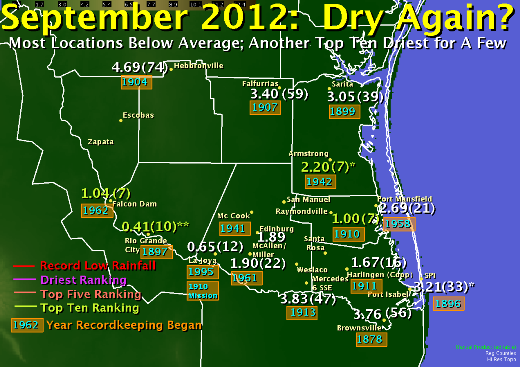
Rainfall rankings for selected locations across the Rio Grande Valley, September 2012
Rainfall rankings for selected climate locations across the Rio Grande Valley.
* Location missing approximately one third of data in sample.
** Location had several gaps in data years, which may have began in 1892.
Hot, Dry Theme Extends into Start of 2012/2013 School Year
 
2012 Atlantic Hurricane Season Ends for Texas Coast
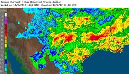
Estimated rainfall totals for September 2012 across the state of Texas
Rainfall Estimates for the State of Texas, September 2012.
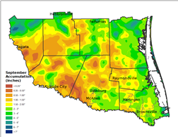
Estimated rainfall for the Rio Grande Valley, from bias corrected rainfall and observations, September, 2012
Rainfall Estimates, from bias corrected radar and ground observations, for the Rio Grande Valley, September 2012.
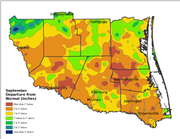
Estimated departure from average rainfall for the Rio Grande Valley, from bias corrected rainfall and observations, September, 2012
Rainfall Departure from Average (Estimates), from bias corrected radar and ground observations, for the Rio Grande Valley, September 2012. Departures are based on the 1981 to 2010 30 year sample.

Endless summer, again?

It sometimes seemed like it in September 2012. While not as searing hot, or dry, as September 2011, the general heat and lack of ranifall that dominated the summer of 2012 continued into the first quarter of September. Afternoon temperatures continued to soar over 100°F away from the coast, with overnights remaining above 80°F through the 8th. McAllen/Miller Airport added another seven days to their annual century mark tally, with 75 days through early October. The first front of the early (climatological) autumn pulled temperatures toward or just below seasonal averages for the second and third quarter of the month (90s in most areas). The final quarter saw similar temperatures, which ended up a few degrees above average as the high pressure ridge that dominated northern Mexico and the Southwest U.S. persisted...until just before month’s end. On the 28th and 29th, remnants from Eastern Tropical Pacific Tropical Storm Norman brought much of Texas much needed, efficient tropical rains, which dropped 4 to 8 inches of rain from the Coastal Bend to the Rio Grande Plains, and 5 to 10 inches from West Texas through the Hill Country, with another batch across East Texas (above left).

For the Rio Grande Valley, rain fell again in fits and starts. Fits and starts typically does not add up to the wettest month of the year, when rainfall averages from just under 4 inches across the Rio Grande Plains to just over 6 inches along the southeast Cameron County coast. Indeed, with the exception of ranchland from northern Jim Hogg through northern Zapata County, where the bulk of the month’s rain fell overnight on the 28th and 29th, and a sliver along the coast from South Padre Island to Boca Chica Beach, most of the Rio Grande Valley fell 2 to more than 3 inches short of these averages (left). Even Brownsville, which came close to catching up during the final three days of the month, still fell short.

Preliminary Temperature and Rainfall, September 2012
Location
Average Temp.
Hot Ranking
McAllen/Cooperative (since 1941)
85.6
3
McAllen/Miller Airport (since 1961)
85.57
3
La Joya/Mission (since 1910)
85.9
3
Armstrong (since 1942)*
82.2
5
Mercedes (since 1913)
82.7
12
Brownsville (since 1878)
83.35
13
Port Isabel (since 1928)
82.8
15
Falcon Dam (since 1962)
83.7
17
Hebbronville (since 1904)*
81.8
19
Harlingen/Coop (since 1911)
82.8
20
Rio Grande City (since 1897)
83.9
23
Raymondville (since 1913)
82.2
24
Port Mansfield (since 1958)
79.6
34
*Missing more than 25 percent of data or years broken up (Armstrong).
Please note that some sites do not have a complete record back to the listed starting year.

How Now, Drought?
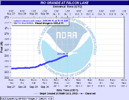
The lack of rainfall during summer, 2012, combined with the large area of more than 2 inches below September average told the tale by month’s end: Extreme to Exceptional Drought in many areas, with pockets of improvement across the Upper Valley Ranchlands after local deluges overnight on the 28th into the 29th. While local water tables in growing areas remained low, and would likely not change much through October, typically a rapidly drying month, there was some small hope for a temporary stanching of the water decreases in Falcon and Amistad International Reservoirs, at least through the first half of October. Torrential and efficient tropical rainfall across the Rio Grande Basin, courtesy of Tropical Storm Norman and other plumes related to the remnants of Hurricane Miriam, allowed for at least some notable rise in Falcon Reservoir, and a temporary reversal of necessary releases from Amistad (right). As of October 2nd, non–release induced rises at Amistad were helping the reservoir rise toward 25 percent capacity, a slight but important increase over the near sub–19 percent minimum in mid August.

The drought, meanwhile, soldiers on. The latest outlook through the rest of 2012 suggest some improvement but not complete erasure, as the combined impact of the puzzle pieces of a weak El Niño and other factors such as the North Atlantic/Arctic Oscillation and regional patterns were very uncertain as the Valley moved deeper into autumn.

Graph of slight rises at Falcon International Reservoir from the end of September into early October 2012
Rainfall Estimates for the State of Texas, September 2012.
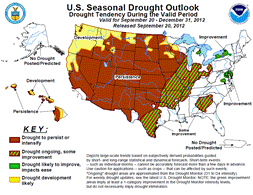
National Droughtlook issued in late September 2012 for the remainder of the calendar year 2012
National "Droughtlook" for the end of September through December 31, 2012.