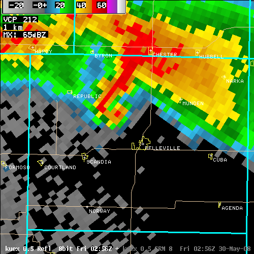
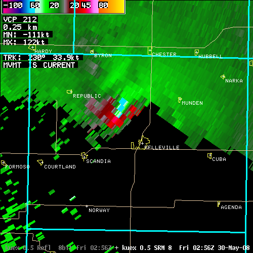
Thursday evening May 29th, a supercell thunderstorm moving across north central Kansas, produced a number of tornadoes. As the storm moved into Republic county, the first report of a tornado touchdown in that county was from 4 miles south of Courtland. The supercell then moved northeast and exited the county northwest of Munden. There were numerous reports of power poles down and power outages, with several farmsteads damaged from near Courtland to north of Belleville.
Additionally, shortly after that, a bow echo moved east across Republic county producing straight line wind damage.
Meteorologists from the National Weather Service in Topeka, along with emergency management in Republic county, have completed the damage survey of Republic County. A complete write-up is now available below.
| ...STORM SURVEY...REPUBLIC COUNTY TORNADO MAY 29TH... ...A DAMAGE SURVEY HAS BEEN COMPLETED BY NWS TOPEKA STORM SURVEY TEAM FOR THE TORNADO THAT STRUCK REPUBLIC COUNTY THE NIGHT OF MAY 29TH. IT WAS DETERMINED THAT A SINGLE TORNADO CAUSED DAMAGE ACROSS NORTHWEST REPUBLIC COUNTY. THE TORNADO WAS RATED EF-3 AND HAD A CONTINUOUS PATH OF 30 MILES ACROSS THE COUNTY. THE TORNADO CROSSED FROM JEWELL COUNTY (NWS-HASTINGS COUNTY WARNING AREA) INTO REPUBLIC COUNTY NEAR THE INTERSECTION OF TIMBER AND 10 ROADS. AT THAT LOCATION...THERE WERE NUMEROUS TREES DAMAGED AND SEVERAL OUTBUILDINGS DESTROYED AT A RESIDENCE...AND AN OLD ROCK HOME WAS DESTROYED. THE TORNADO CONTINUED NORTHEAST...AND PASSED JUST SOUTH OF COURTLAND. SEVERAL AREAS OF TREE DAMAGE...POWERLINE DAMAGE...AND OVERTURNED CENTER PIVOT IRRIGATION UNITS WERE OBSERVED. ONE MILE SOUTHEAST OF COURTLAND...POWERLINES WERE DOWNED...A LARGE METAL OUTBUILDING WAS DAMAGED...AND TREES WERE DAMAGED. THREE MILES NORTH AND TWO MILES EAST OF SCANDIA...SIGNIFICANT TREE DAMAGE WAS OBSERVED. NUMEROUS TREES WERE COMPLETELY UPROOTED AND THROWN FOR HUNDREDS OF YARDS. ONE RESIDENCE FEATURED MINOR DAMAGE TO THE HOME...BUT HAD SEVERAL OUTBUILDINGS DESTROYED. METAL I-BEAMS WERE OBSERVED TO HAVE BEEN BLOWN INTO THE FIELDS EAST AND WEST OF THIS LOCATION. THE UNION VALLEY CEMETERY SUSTAINED SIGNIFICANT DAMAGE TO CEDAR TREES AND HEADSTONES. AN OLD SCHOOL HOUSE WAS ALSO DESTROYED. THE WIDTH OF THE DAMAGE PATH AT THIS LOCATION WAS 3/8THS OF A MILE WIDE. FIVE MILES NORTH AND TWO MILES WEST OF BELLEVILLE NEAR THE INTERSECTION OF 150TH AND HICKORY ROADS...SIGNIFICANT DAMAGE WAS OBSERVED AT A HOME. PORTIONS OF THE ROOF WERE REMOVED FROM THE HOME...A PICTURE WINDOW ON THE NORTH SIDE OF THE HOME WAS BROKEN OUT...AND THE EAST SIDE WALL OF THE HOME WAS BLOWN OUT. SEVERAL LARGE BARNS...OUTBUILDINGS...AND GRAIN BINS WERE DESTROYED AT THIS RESIDENCE AS WELL. NORTH OF THIS RESIDENCE ALONG 150TH ROAD...FOUR GRAIN BINS WERE DESTROYED...AND SOME FARM EQUIPMENT WAS DAMAGED. A CONTINUOUS PATH OF DAMAGE WAS OBSERVED IN THE TREES BETWEEN THE DAMAGED RESIDENCE AND THE DESTROYED GRAIN BINS. THE DAMAGE PATH WAS 3/4THS OF A MILE WIDE AT THIS LOCATION. THE TORNADO CONTINUED TO MOVE TO THE NORTHEAST AND CROSSED HIGHWAY 81...1/4 MILE NORTH OF FIR STREET. THERE...THE TORNADO PRODUCED DAMAGE TO TREES...DESTROYED OUTBUILDINGS...AND SLIGHTLY DAMAGED A HOME. THE DAMAGE PATH WAS 1/10TH OF A MILE WIDE AT THIS LOCATION. THE TORNADO CONTINUED MOVING NORTHEAST...AND CAUSED DAMAGE TO TREES AND POWERLINES ALONG ITS PATH. THE TORNADO CROSSED THE STATE LINE AND MOVED IN NEBRASKA AT THE INTERSECTION OF 240 ROAD AND ASH STREET...AND CAUSED DAMAGE IN HUBBELL. AGAIN...THE TORNADO TRAVELED ALONG A CONTINUOUS PATH INTO NEBRASKA. DETAILS ON THE NEBRASKA PORTION OF THE PATH ARE AVAILABLE ON THE WEBSITE FOR THE NATIONAL WEATHER SERVICE OFFICES IN HASTINGS AND OMAHA. THE TORNADO HAD A PATH LENGTH OF 30 MILES IN REPUBLIC COUNTY ALONE. THE TORNADO WAS RATED AN EF-3 FROM ITS ENTRANCE INTO REPUBLIC COUNTY UNTIL IT CROSSED HIGHWAY 81. THE TORNADO WAS DETERMINED TO HAVE CAUSED EF-2 DAMAGE FROM HIGHWAY 81 UNTIL ABOUT TWO MILES SOUTH OF THE STATE LINE. THEREAFTER...THE TORNADO WAS DETERMINED TO HAVE CAUSED EF-1 DAMAGE. FOR A DESCRIPTION OF THE ENHANCED FUJITA (EF) SCALE...PLEASE VISIT WWW.SPC.NOAA.GOV/EFSCALE |
 |
| Reflectivity image at 956 PM May 29 2008. |
 |
| Storm Relative Velocity image at 956 PM May 29 2008 |
Click on any of the images below for a larger view.