
Tropical Depression Two is expected to gradually strengthen and could bring tropical storm conditions to the Florida Panhandle beginning late Monday. Areas of flash flooding will be possible through Thursday along the eastern and central Gulf Coast. Severe thunderstorms will develop and move along a cold front crossing the Upper Midwest Monday, and through the Ohio Valley/Mid-Atlantic on Tuesday. Read More >
Discrete supercells pushed from north central Kansas to east central Kansas the morning of June 2nd, and produced extremely large hail and damage winds. In addition, heavy rainfall led to localized flooding. A complete write-up of the severe weather event will be available sometime tomorrow. For now, a list of the Storm Reports received locally are available below.
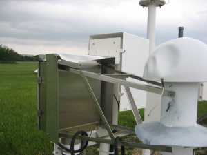
The Manhattan ASOS (Automated Surface Observation Station) sustained damage during the storms as well. Note the "softball sized" dents on the instrumentation below. Local Electronics Technicians have since been able to repair the ASOS, and data flow had returned to normal.
(Click images for a larger view)
 |
 |
|
Manhattan (KMHK) ASOS Hygrothemometer (Temperature/Dewpoint Sensor) |
Manhattan (KMHK) ASOS Hygrothemometer (Temperature/Dewpoint Sensor) |
 |
 |
|
Hail damaged cars near the airport |
Damaged car near the airport |
An NWS-Topeka Storm Survey crew sruveyed the straight line wind tree and property damage in northern Franklin County . Winds were estimated to have gusted to 60-70 mph.
(Click images for a larger view)
 |
 |
|
Powerlines blown down |
Large tree limbs blown down |
Flash flooding was also a concern at several locations. Storms were exceptionally efficient rainfall producers. The Topeka ASOS recorded 1.69 inches of rainfall in one hour, between 11am and noon! 0.57" fell between 10am and 11am. Manhattan also recorded heavy rain--with 1.08 inches measured between 10am and 11am, and 0.61" the hour before that.
(Click images for a larger view)
 |
 |
|
Flooding near the airport |
Flooding near the airport |

