
A Nor'easter will create hazardous marine and coastal conditions along the Mid-Atlantic coast through mid-week, with significant coastal flooding and beach erosion possible. Meanwhile, another strong storm system is forecast to bring high winds and heavy precipitation to portions of southern Alaska. Elsewhere, relatively benign weather is expected through the first half of the work week. Read More >
A potent area of low pressure pushed across the southern plains on Wednesday and Thursday November 29th and 30th. After record high temperatures on Tuesday...a cold front pushed through northeast Kansas Tuesday night bringing thunderstorms to far eastern Kansas along with a quick end to the warm weather for the entire area. A round of sleet and freezing rain was experienced on Wednesday...this brought very slick roads and hazardous driving conditions to much of the region. The upper low then tracked across Oklahoma, southeast Kansas and into Missouri. As is usually the case with these types of winter storms, a steep gradient of snowfall was observed. Snowfall totals ranged from a trace or less from a Lawrence to Council Grove line to up to 8 to 10 inches in Anderson, Coffey and Franklin counties. In Douglas county alone, Lawrence saw a few flakes while in the southeast part of the county, Baldwin City picked up 6 to 8 inches.
Below is a graphical representation of the snowfall amounts from the storm, followed by a county summary of snow fall.
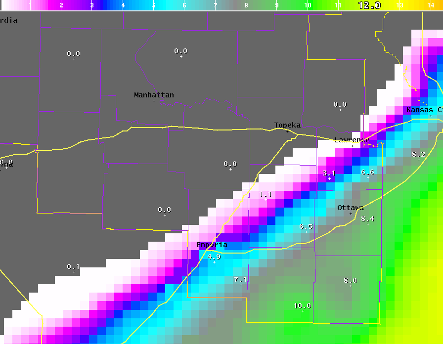
ANDERSON COUNTY...GENERALLY 6 TO 8 INCHES WITH A FEW LOCATIONS
REPORTING 9 TO 10 INCHES. SOME DRIFTS AS HIGH AS 15 INCHES WERE REPORTED.
COFFEY COUNTY...8 TO 10 INCHES. SOME DRIFTING OF SNOW.
DOUGLAS COUNTY...LITTLE IF ANY ACCUMULATIONS IN THE CITY OF
LAWRENCE BUT 6 TO 8 INCHES IN THE BALDWIN CITY VICINITY...WITH
DRIFTING ACROSS ROADS IN THAT AREA.
FRANKLIN COUNTY...6 TO 11 INCHES FOR THE COUNTY...WITH 10 TO 11
INCHES IN THE OTTAWA VICINITY. DRIFTS AS HIGH AS 2 FEET WERE
REPORTED.
LYON COUNTY...AROUND 5 INCHES IN EMPORIA. REPORTS OF 6 TO 7 INCHES
IN THE HARTFORD AREA. DRIFTING OCCURRING ESPECIALLY NEAR THE
COFFEY COUNTY LINE.
OSAGE COUNTY...6 TO 8 INCHES WITH DRIFTING OF SNOW ACROSS SOME ROADS.


 Follow us on X
 Follow us on Facebook
 Follow us on YouTube
 TOP RSS Feed