|
Tornadoes and Severe Weather Events September 7, 2001
Severe storms erupted over central Kansas Friday afternoon, September 7, and moved east across north central and northeast Kansas during the evening hours. The storms formed ahead of a strong cold front entering the region.
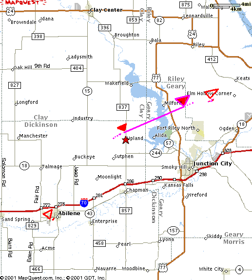
Numerous reports of severe weather (3/4 inch or larger hail, and/or 58 mph or higher wind) and tornadoes occurred across the WFO Topeka county warning area. Most significant damage occurred in 3 tornadoes that moved across parts of Dickinson, Geary and Riley counties:

In addition, widespread wind damage was reported through Coffey, Anderson, Osage, Franklin, Douglas and Jefferson counties.
The initial tornado began near Upland about 525PM in northeast Dickinson county, moving northeast into Geary county, before dissipating just east of Milford Lake. Tree damage was extensive along the path with about a half dozen structures also damaged. No injuries nor deaths occurred. This tornado was rated F1 with winds estimated in the 73 to 112 mph range. The same parent thunderstorm produced another short F0 (winds up to 72 mph) tornado in Riley county over Ft Riley military base shortly after 6pm. Here are a few radar images from the evening:
Another tornado reformed southwest of Abilene and caused damage in and around the park in the city of Abilene about 6pm. This tornado was also rated F0. Again, no injuries or fatalities occurred.
Winds estimated from 70 to 100 mph tore across east central Kansas damaging numerous trees and several structures. Damage was especially significant in around the Lawrence, Baldwin City, Ottawa and Garnett communities. Large hail accompanied many of the storms during the evening also.
Pictures of Douglas County Wind Damage
Photos courtesy of Mike Umscheid and Lawrence Journal-World
Pictures of Dickinson and Geary County tornado and damage
Photos courtesy of Billy Hansen
|
