| April 24, 2010 Tornadoes | ||||||||
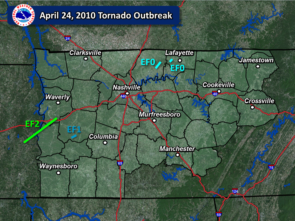
| # | Counties | Rating | Time (CST) | Length (miles) | Width (yards) | Fatalities | Injuries | |
| 1 | Decatur/Perry/Humphreys | EF2 | 1526 | 25.6 | 400 | 0 | 0 | |
| 2 | Hickman | EF1 | 1736 | 1.84 | 100 | 0 | 0 | |
| 3 | Sumner | EF0 | 1824 | 3.75 | 50 | 0 | 0 | |
| 4 | Macon | EF0 | 1840 | 1.51 | 50 | 0 | 0 | |
| Reports & Outlooks | |
| SPC Outlooks | SPC Storm Reports |
| SPC Event Archive | Public Information Statements |
| EF2 Decatur/Perry/Humphreys Tornado | |
| Counties: | Decatur/Perry/Humphreys |
| Time: | 3:26 PM CST |
| EF Scale: | EF2 |
| Wind Speed Estimate (Perry/Humphries Counties): | 115 MPH |
| Damage Path Length: | 25.6 miles |
| Damage Path Width (Perry/Humphreys Counties): | 400 yards |
| Start Point: | 35.684/-88.1386 |
| End Point: | 35.882/-87.754 |
| Fatalities: | 0 |
| Injuries | 0 |
|
Damage: SHAMBURGER (2024) - The severe degree of tree damage from this tornado on high resolution satellite imagery across Decatur County strongly suggests an EF2 rating is warranted for this tornado instead of the official rating of EF1, although the damage across Perry and Humphreys County was EF1. The path of this tornado was also adjusted based on the damage path on high resolution satellite imagery. |
|
| EF1 Hickman County Tornado | |
| Counties: | Hickman |
| Time: | 5:36 PM CST |
| EF Scale: | EF1 |
| Wind Speed Estimate: | 90 MPH |
| Damage Path Length: | 1.84 miles |
| Damage Path Width: | 100 yards |
| Start Point: | 35.6478/-87.5184 |
| End Point: | 35.6674/-87.4962 |
| Fatalities: | 0 |
| Injuries: | 0 |
|
Damage: SHAMBURGER (2024) - The official time of this tornado at 5:15 PM CST is incorrect and does not match up with radar data, and was corrected here. The tornado path was also adjusted slightly from official Storm Data records using high resolution satellite imagery. |
|
| EF0 Sumner County Tornado | |
| Counties: | Sumner |
| Time: | 6:40 PM CST |
| EF Scale: | EF0 |
| Wind Speed Estimate: | 85 MPH |
| Damage Path Length: | 3.75 miles |
| Damage Path Width: | 50 yards |
| Fatalities: | 0 |
| Injuries: | 0 |
|
Damage: SHAMBURGER (2024) - This tornado, which is not in any official records or storm reports, was found using high resolution satellite imagery and a strong velocity couplet on OHX radar data. This small, weak tornado touched down west of Rock Bridge Road and moved northeast across rural, hilly terrain west of Bethpage. The tornado then crossed Red Tuttle Road and Mount Vernon Road before lifting east of Duffer Hollow Road. Several trees were snapped and uprooted in a strongly convergent pattern along the path, and one old barn suffered minor damage on Red Tuttle Road. |
|
| EF0 Macon County Tornado | |
| Counties: | Macon |
| Time: | 6:40 PM CST |
| EF Scale: | EF0 |
| Wind Speed Estimate: | 85 MPH |
| Damage Path Length: | 1.51 miles |
| Damage Path Width: | 50 yards |
| Start Point: | 36.534/-86.19 |
| End Point: | 36.554/-86.179 |
| Fatalities: | 0 |
| Injuries: | 0 |
|
Damage: SHAMBURGER (2024) - The time and path of this tornado were adjusted slightly from official Storm Data records using radar data and high resolution satellite imagery. |
|

