
Tropical Depression Two is expected to gradually strengthen and could bring tropical storm conditions to the Florida Panhandle beginning late Monday. Areas of flash flooding will be possible through Thursday along the eastern and central Gulf Coast. Severe thunderstorms will develop and move along a cold front crossing the Upper Midwest Monday, and through the Ohio Valley/Mid-Atlantic on Tuesday. Read More >
Omaha/Valley, NE
Weather Forecast Office
A storm system brought snow to parts of the area on Easter Sunday, April 1st. Some locations in southeast Nebraska received 6 to 10" of snow, while other parts of the local area received no snow at all. The snow set up in a very narrow band that was only about 10 to 25 miles wide.
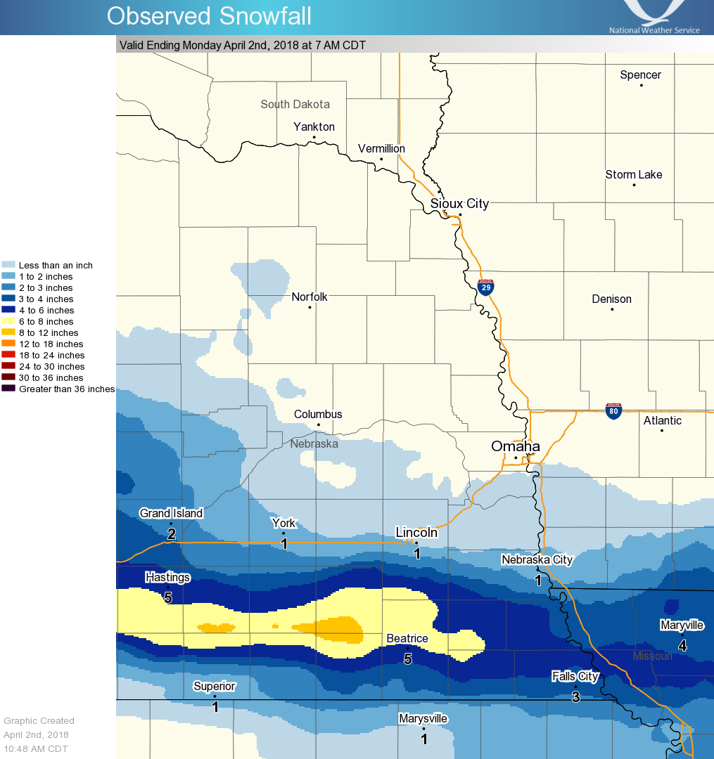
Here are some notable snowfall totals:
Crete, NE 10"
Tobias, NE 9"
Daykin, NE 6.7"
Auburn, NE 6.2"
Tecumseh, NE 6.0"
Table Rock, NE 6.0"
Adams, NE 5.5"
Falls City, NE 5.5"
Fairbury, NE 5.5"
Hickman, NE 5.0"
Wilber, NE 5.0"
Beatrice, NE 4.7"
Virginia, NE 4.0"
Salem, NE 4.0"
Verdon, NE 4.0"
Shubert, NE 4.0"
Clarinda, IA 1.5"
Malcom, NE 1.1"
Sidney, IA 1.1"
Lincoln, NE (airport) 0.8"
Seward, NE 0.5"
Omaha, NE (airport) 0
Warnings/Hazards
Forecast Discussion
Winter Weather
Severe Weather
Fire Weather
Drought
Storm Prediction Center
SubmitReport
Rivers And Lakes
River Forecasts
Missouri River Overview
Platte River Overview
Elkhorn River Overview
Ice Jam Risk
Local Information
Latest Briefing Packet
Weather Monitor
Winter Monitor
Preparedness
Storm Spotters
About Us
Other Useful Links
US Dept of Commerce
National Oceanic and Atmospheric Administration
National Weather Service
Omaha/Valley, NE
6707 North 288th Street
Valley, NE 68064-9443
402-359-5166
Comments? Questions? Please Contact Us.

