|
Storms Visit Parts of West Texas |
 |
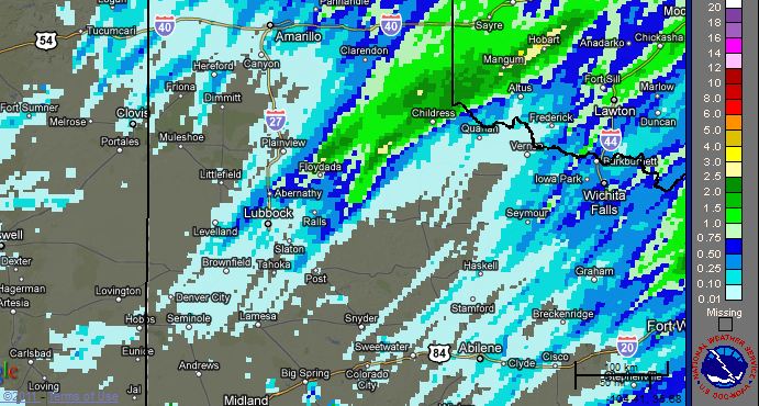
| Radar estimated rainfall for the 24 hour period from 6 am on Monday (21 November 2011) to 6 am on Tuesday (22 November 2011). To view a map with observed rain totals CLICK HERE. |
|
The combination of a cold front and lift from an approaching upper level storm system was enough to generate showers and thunderstorms over part of the South Plains and Rolling Plains on Monday, 21 November 2011. Even though temperatures at ground level were only in the 30s and 40s, much warmer and moister air was present a couple thousand feet above the ground. When this warm and moist air was lifted, scattered thunderstorms quickly developed Monday morning, then raced to the northeast. Activity continued to redevelop over some of the same spots through the afternoon hours before shifting northeast of the area. Locations from the northeast South Plains into the southeast Texas Panhandle received the heaviest rains (see the above graphic), in some cases over 2 inches. |
|
|
| Lubbock WSR-88D base reflectivity animation from 8 am to 4 pm on 21 November 2011. The "KLBB" marks the location of the radar at the airport in Lubbock. |
|
Childress officially recorded 2.38 inches of rain on the day, a new daily and monthly record. In addition, this rainfall pushed Childress to 10.53 inches for the year. Although still over 12 inches below normal for the year, this does now ensure that 2011 will not be an all-time record dry year for Childress. The driest year on record at Childress is 1956, when only 10.44 inches fell. Lubbock, on the other hand, only recorded 0.22 inches. This raised Lubbock's yearly total to a paltry 4.30 inches, or 13.83 inches below normal. Unless the end of the year brings unprecedented precipitation, 2011 is likely to go down as the driest year on record for Lubbock. Currently, the driest year on record at Lubbock is 1917, when 8.73 inches of rain was recorded. To view a more complete tabular summary of rain totals around the area CLICK HERE. |
| The Maximum Expected Size of Hail (MESH), as estimated from radar, for 21 November 2011. The blue swaths correspond to pea to quarter sized hail. Click on the image for a larger view. |
| The storms not only brought rain and intense lightning, the stronger cells also produced hail. Most of the hail was rather small, but a few storms did generate hail to around an inch in diameter, including at Smyer and near Abernathy. The above image displays where automated algorithms, using radar data, indicate that swaths of larger hail fell. |
| Visible satellite image taken at 4:15 pm on 21 November 2011. Taller clouds corresponding to showers and thunderstorms are noted in eastern New Mexico and from North Texas into Oklahoma and the eastern Texas Panhandle. Low stratus clouds are in place across the South Plains into the Rolling Plains. Click on the picture to enlarge. |