National Weather Service United States Department of Commerce

Regional Outbreaks of Severe Weather Through Early Next Week; Early Season Heat Wave across the South

Active spring pattern across the center of our nation with several episodes of severe weather and heavy rainfall expected into next week. The potential for very large hail, long track tornadoes, severe wind gusts, frequent cloud to ground lightning strikes and flash flooding are in the outlook. Furthermore, dangerous early season heat wave continues for the Gulf Coast states into early next week. Read More >


The Emergency Managers Weather Information Network -- EMWIN -- is a service that allows users to obtain weather forecasts, warnings, and other information directly from the National Weather Service (NWS) in almost real time. EMWIN is intended to be used primarily by emergency managers and public safety officials who need timely weather information to make critical decisions.

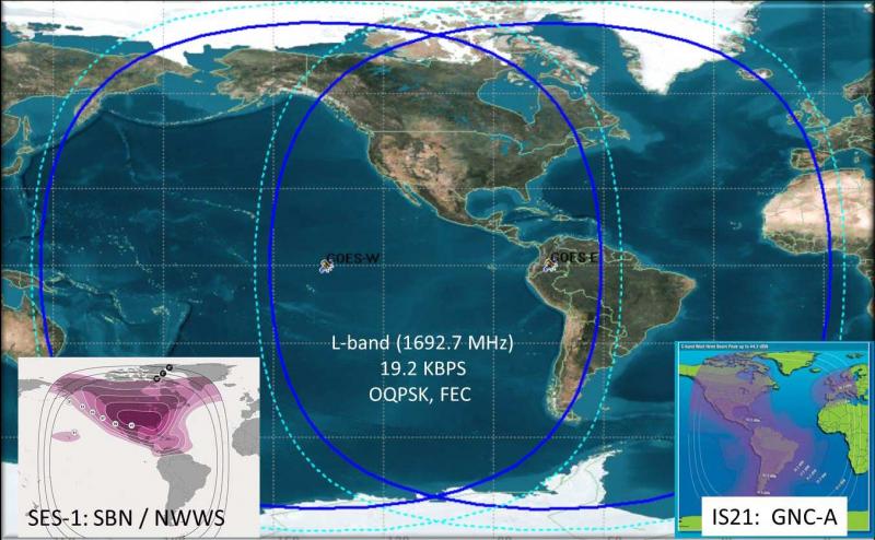
Emergency Managers Weather Information Network (EMWIN) offers an economical way to receive all products available on the NWWS, plus graphical forecasts and select satellite data. Compared to the NWWS, typically, an additional broadcast delay of 5 to 20 seconds can be expected for watches and warnings, as compared to the NWWS delay. The EMWIN system is monitored on 24 hours per day, 7 days a week, and has an estimated availability of at least 99%. EMWIN systems are available from many private industry suppliers. The service itself is free.

  • Developed in partnership with the National Oceanic and Atmospheric Administration (NOAA) National Environmental Satellite, Data, and Information Service (NESDIS), and other public and private organizations
  • Provides open public access without fee, to a managed set of US National and World Meteorological Organization (WMO) International warnings, watches, forecasts, and other products.
  • Sequences highest-priority/most-urgent products ahead of all lower priorities products
  • Supplements other US NOAA/NWS dissemination services, including:
    • NESDIS GEONETCast Americas (GNC-A) satellite broadcast service
    • NOAA Weather Wire System (NWWS) satellite broadcast and Internet services
    • SBN-NOAAPORT Broadcast System
    • NOAA Weather Radio (NWR) VHF Broadcast Service
    • NWS Information Dissemination Service (NIDS) Internet Services
    • NWS Global Telecommunication System (GTS) Internet File Service (GIFS)


GOES Satellite Footprint Extent of EMWIN Broadcast

EMWIN satellite broadcast footprint image


EMWIN Dissemination Platforms and Stakeholders

EMWIN Dissemination Platforms:

Stakeholders:

  • EMWIN, LRIT and GOES-R HRIT/EMWIN Broadcast Interface Community
    • Broadcast Receivers and Antenna Systems
  • Application Software Community
  • Information End User Communities:
    • US National Users – Government, commercial, public and private
    • WMO Regional Association IV (RA-IV) Member States
    • Adjacent WMO Regions (RA-III and RA-V; Pacific Ocean Region)