Record setting heat is expected over the next several days from the Intermountain West through the northern Plains. Furthermore, fire weather concerns increase with dry and breezy conditions. Meanwhile, heavy rainfall and severe thunderstorm threats for the Ohio/Tennessee Valleys, central Appalachians and Southeast today. The threat shifts to central Gulf Coast and across central Texas this week. Read More >
Overview
|
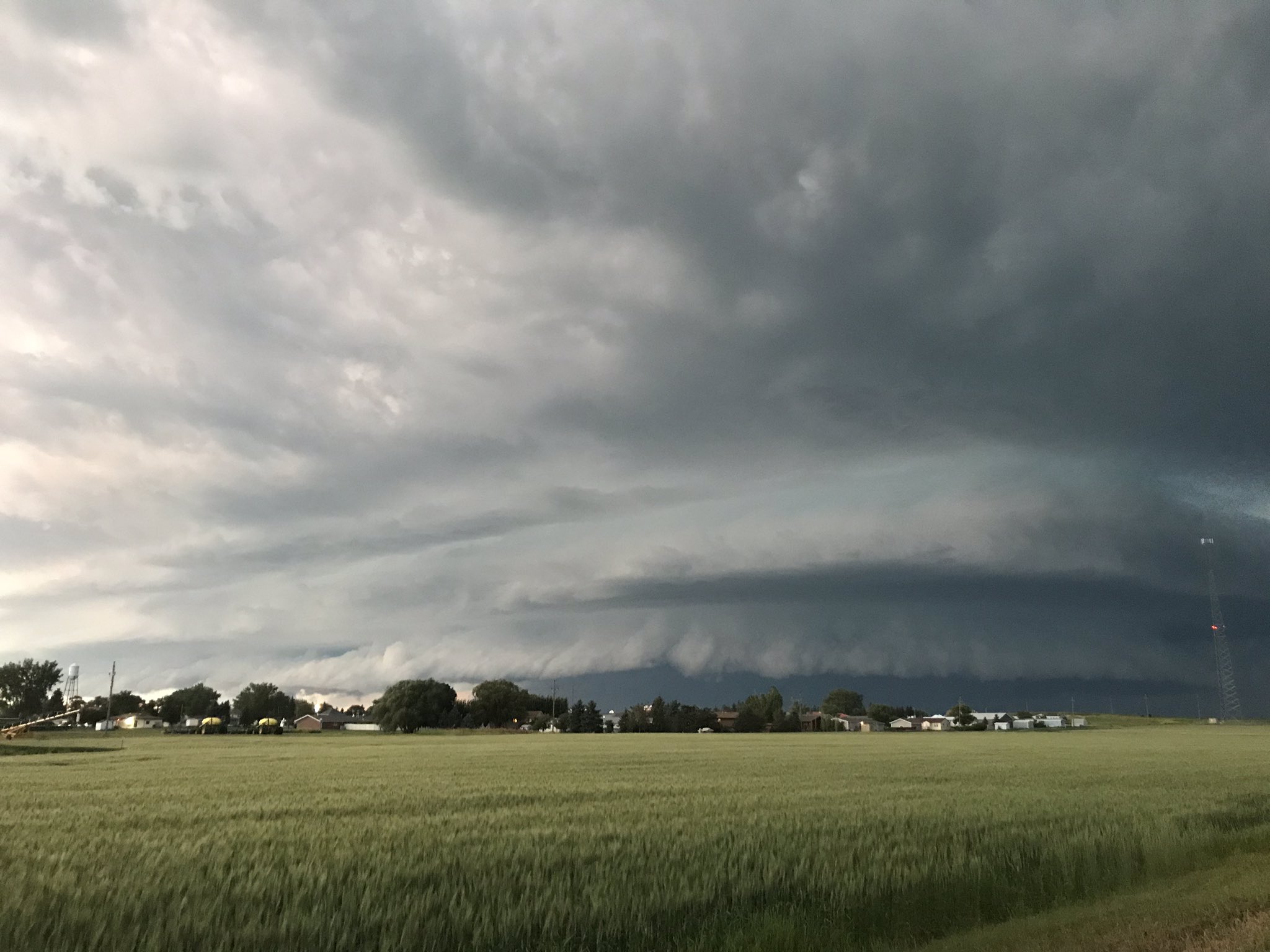
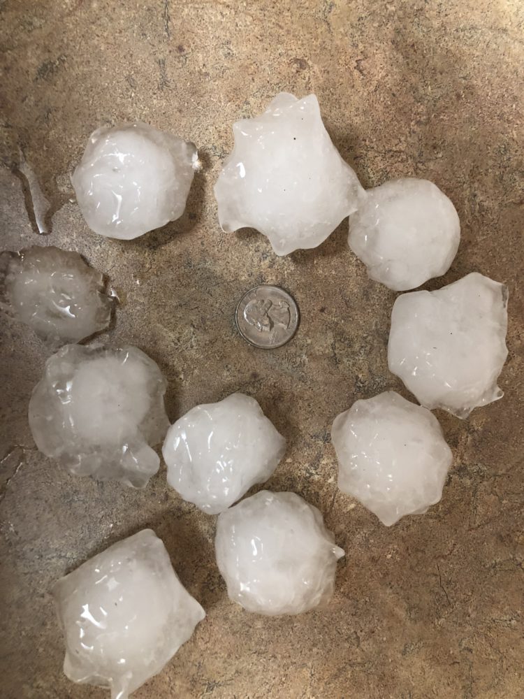
Late in the afternoon on July 12, 2019, several discrete supercell thunderstorms developed across the Canadian border in southern Saskatchewan. These storms went on to produce severe weather across parts of northwestern North Dakota, including a measured 68 mph wind gust near Tioga, ND. As evening approached, new storms began to rapidly intensify further south around Dickinson, ND. One of these new storms quickly developed an intense mesocyclone, dropping golf ball size hail around Lefor, ND before heading towards Mott, ND. Just north of Mott, an EF-1 tornado touched down around 9:24 MDT moving south southeast. Wind gusts of 72 mph and 90 mph were measured by a North Dakota Agricultural Weather Network (NDAWN) station, likely associated with the outer edge of the tornadic circulation. The tornado then tracked through northeastern Mott before lifting just east of town about eight minutes later, near Mott Golf Course on highway 21. Storms continued well into the morning hours of July 13, 2019, producing more sporadic severe wind and hail reports across parts of southwestern and central North Dakota. |
(Courtesy of Nadra Auch) |
Tornadoes:
|
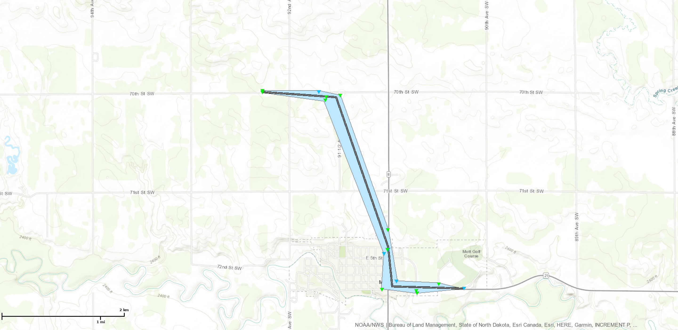
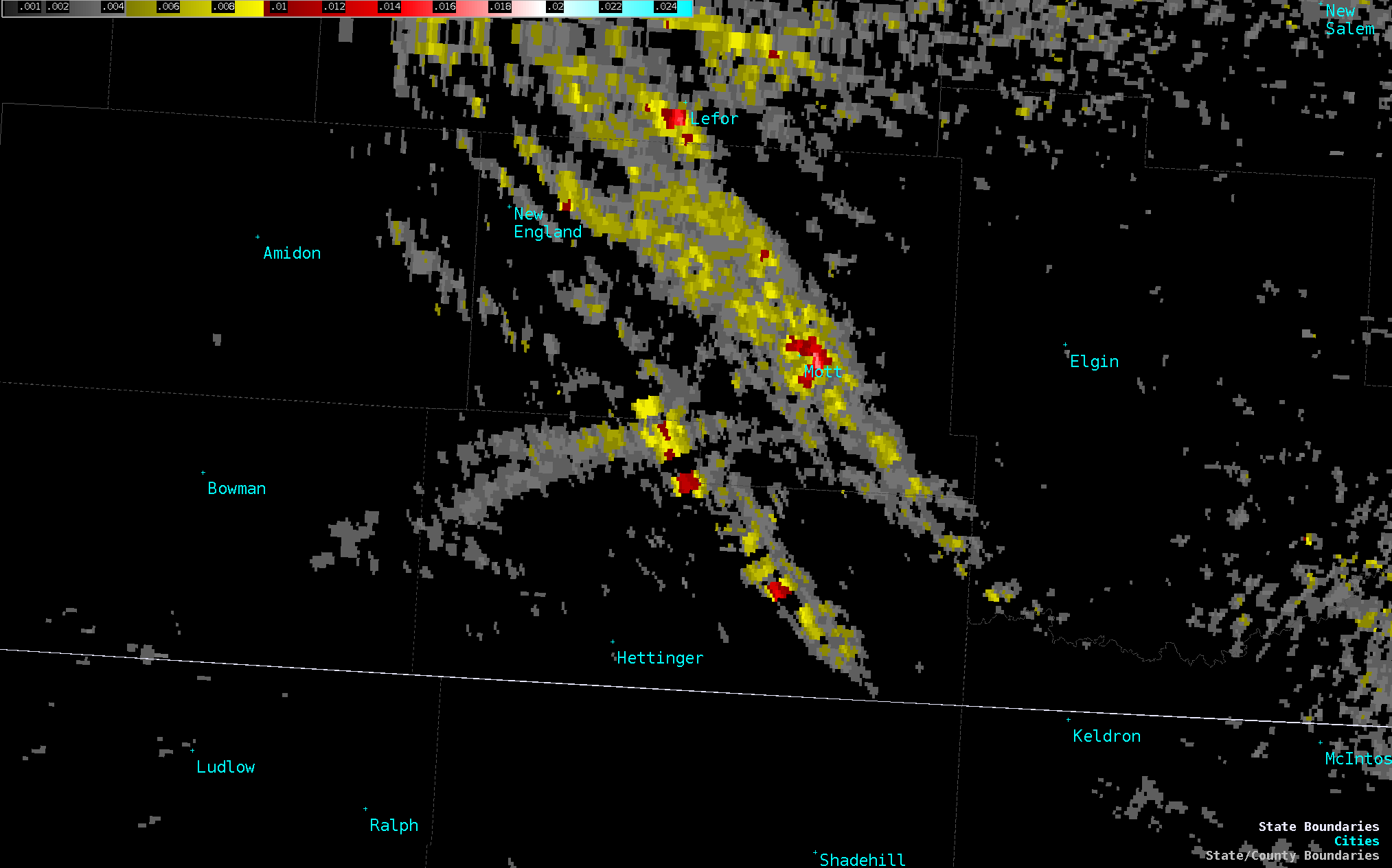
Tornado - MOTT, NORTH DAKOTA
Track Map 
|
||||||||||||||||
The Enhanced Fujita (EF) Scale classifies tornadoes into the following categories:
| EF0 Weak 65-85 mph |
EF1 Moderate 86-110 mph |
EF2 Significant 111-135 mph |
EF3 Severe 136-165 mph |
EF4 Extreme 166-200 mph |
EF5 Catastrophic 200+ mph |
 |
|||||
Photos & Video
 |
 |
 |
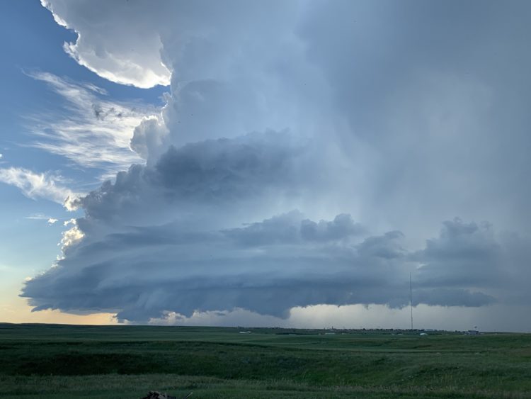 |
| Supercell Over Mott, ND (Courtesy of Nadra Auch) |
Looking Toward Mott, ND from Burt, ND (Courtesy of Jessica Jantzen) |
Golfball Size Hail: 1 Mile South of Lefor, ND (Courtesy of Deana Glaser) |
Supercell: 10 Miles West of Williston, ND (Courtesy of Ashley Fultz) |
Radar
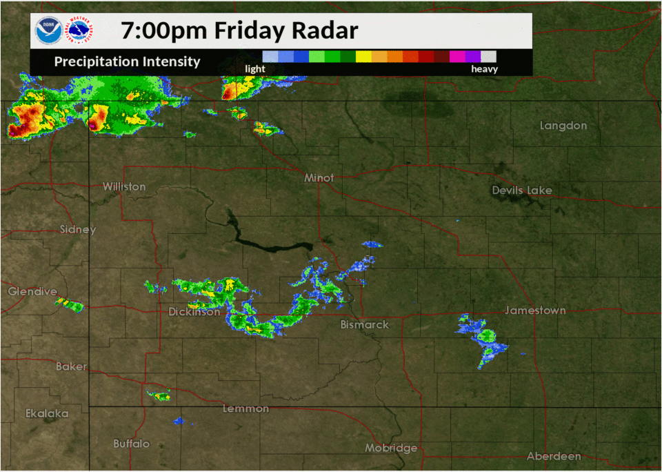 |
 |
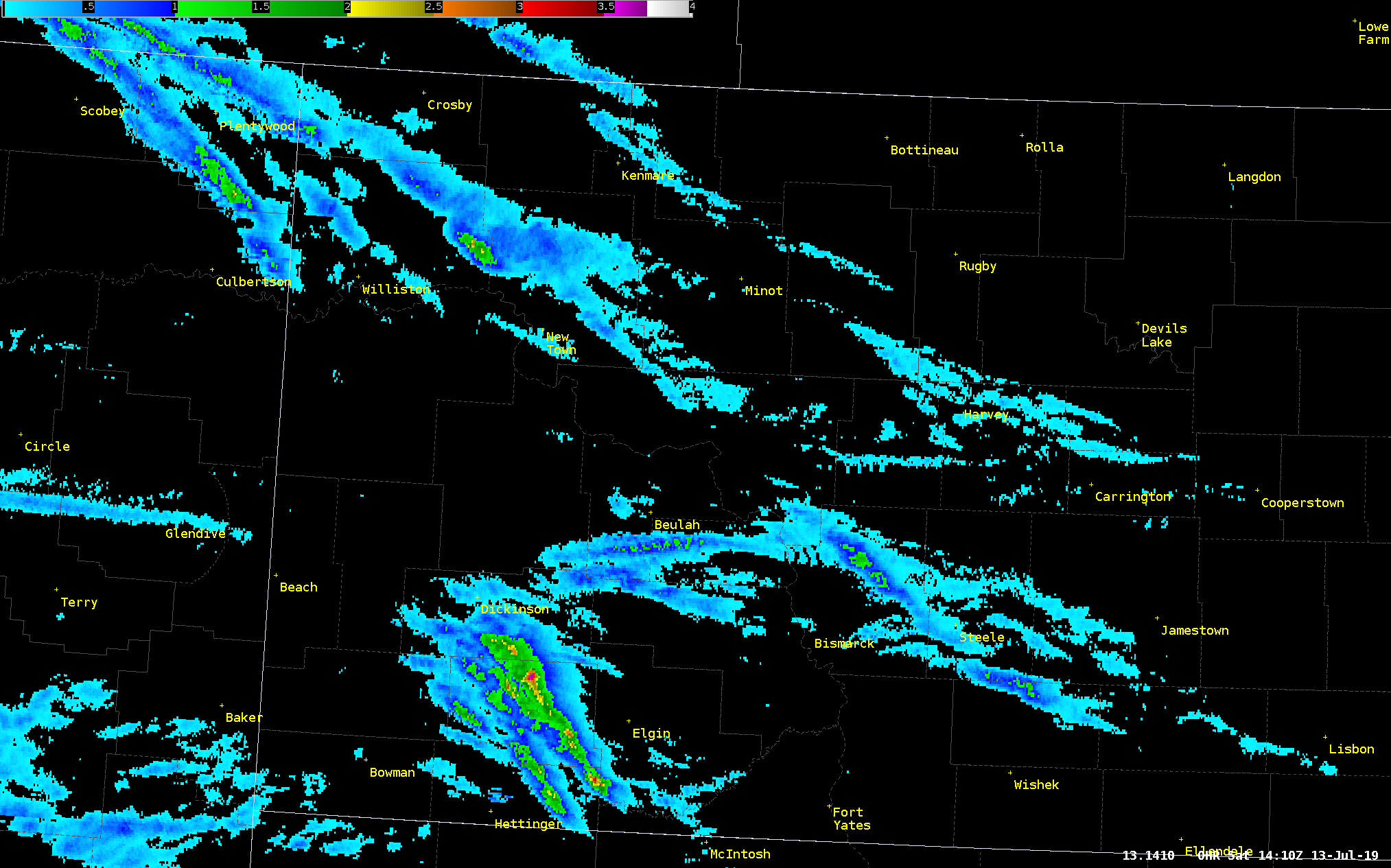 |
| Radar Loop: 7:00pm CDT Friday to 1:00am CDT Saturday | Multi-Radar Multi-Sensor (MRMS) Derived Rotational Tracks | Multi-Radar Multi-Sensor (MRMS) Derived Hail Swaths |
Storm Reports
..TIME... ...EVENT... ...CITY LOCATION... ...LAT.LON...
..DATE... ....MAG.... ..COUNTY LOCATION..ST.. ...SOURCE....
..REMARKS..
0707 PM Tstm Wnd Gst 8 N Grenora 48.73N 103.94W
07/12/2019 M59 MPH Divide ND Mesonet
NDAWN mesonet site.
0835 PM Tstm Wnd Gst 2 SE Tioga 48.38N 102.90W
07/12/2019 M68 MPH Williams ND AWOS
0840 PM Tstm Wnd Dmg 4 S Tioga 48.34N 102.94W
07/12/2019 Williams ND Trained Spotter
Large 8 inch tree branch broken. Time
estimated via radar.
0932 PM Tstm Wnd Gst 1 SW Stanley 48.30N 102.41W
07/12/2019 E60 MPH Mountrail ND Trained Spotter
0935 PM Hail 1 SSW Lefor 46.67N 102.57W
07/12/2019 E1.75 inch Stark ND Trained Spotter
Small tree branches also broken. Time
estimated from radar.
1020 PM Hail 10 S Beulah 47.12N 101.78W
07/12/2019 E1.00 inch Mercer ND Public
Delayed report. Mostly dime to quarter size
hail. Time estimated from radar.
1024 PM Tstm Wnd Gst 1 N Mott 46.39N 102.33W
07/12/2019 M72 MPH Hettinger ND Mesonet
North Dakota Agricultural Weather Network
(NDAWN) station.
1025 PM Hail 7 NW Hannover 47.17N 101.55W
07/12/2019 E1.00 inch Oliver ND Trained Spotter
Delayed report. Mostly pea to nickel size
hail with a few quarters mixed in. Only
lasted about a minute.
1025 PM Tstm Wnd Gst 1 N Mott 46.39N 102.33W
07/12/2019 M90 MPH Hettinger ND Mesonet
North Dakota Agricultural Weather Network
(ndawn) station.
1027 PM Tornado 2 NNE Mott 46.39N 102.31W
07/12/2019 Hettinger ND Law Enforcement
Hettinger County sheriff deputy reports
tornado on the ground northeast of Mott.
1030 PM Tstm Wnd Dmg Mott 46.37N 102.32W
07/12/2019 Hettinger ND Trained Spotter
12 inch diameter tree branch snapped off.
Reports of broken windows in Mott.
1115 PM Hail 11 S Bentley 46.16N 102.03W
07/12/2019 E1.00 inch Adams ND Public
Delayed report. A lot of small hail with a
few stones mixed in as large as a quarter.
Extensive crop damage. Time estimated from
radar.
0110 AM Hail 8 S Havelock 46.36N 102.72W
07/13/2019 E1.00 inch Hettinger ND Trained Spotter
Delayed report. A few quarters but did not
last long. Time estimated from radar.
0120 AM Tstm Wnd Dmg 4 W Regan 47.16N 100.61W
07/13/2019 Burleigh ND Public
Delayed report. Roof blown off of a brand
new farm shop. Time estimated from radar.
 |
Media use of NWS Web News Stories is encouraged! Please acknowledge the NWS as the source of any news information accessed from this site. |
|