|
December Dust Storm 19 December 2012 |
|
|
While certainly not the worst ever dust storm that our part of West Texas has seen, it was certainly of historic significance. Not since December 16th of 1977 have we seen a dust storm of longer duration than that of the 19th of December 2012. Widespread 30 to 45 mph sustained winds were observed over much of the South Plains and Southwestern Texas Panhandle during the day while points east across the Rolling Plains remained under 20 mph for much of the day as high clouds persisted. However, with the arrival of a Pacific front followed by a Canadian front, the entire area saw windy conditions. This event was well forecast with the first mention of the event potential on Saturday, December 15th. A high wind watch was posted on the afternoon of Monday December 17th with an upgrade to a High Wind Warning the next afternoon. A dust storm warning was issued for the affected area in the early morning hours of Wednesday.
|
|
|
Blowing dust across the South Plains Wendesday afternoon as seen from a plane flying overhead. Photo courtesy of Chris Manno. |
|
|
The high clouds previously mentioned always present a challenge in forecasting wind events as their presence tends to reduce the ability of stronger winds aloft to mix down to the surface. In this case, the clouds across the right portion of the image below originated from Pacific moisture which interacted with the mountains of West Texas and Central New Mexico. On Tuesday, it appeared that the clouds would thin and likely push east to near the Caprock Escarpment by about lunchtime and this assumption was quite close. As the thick cloud deck moved east and skies cleared near the Texas/New Mexico state line, winds rapidly increased to the forecast speeds and allowed for the rapid lofting of large amounts of dust. |
|
|
|
|
| NASA MODIS satellite image showing the blowing dust Wednesday afternoon, December 19th, 2012. Click on image for a large view. Notice the white sand being lofted from the White Sands National Monument area. | |
|
|
|
| Scene near site of fatal accident north of Lubbock courtesy of Fox34 TV Lubbock | |
|
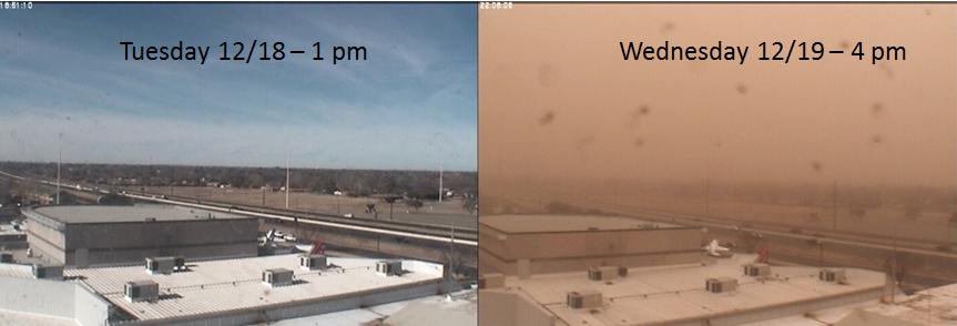
While it is quite common to see wind events with the same velocities as those observed on the 19th, the dust was much denser. Was it the storm which was so strong that it lofted the dust? Actually, the scenario for a high-density dust event has been in the making for some time. With the low precipitation totals experienced the past two years, the amount of vegetation is somewhat reduced. Thus, there is less to hold the dirt in place. More recently, the dust and wind the previous Friday also helped prime the area for more dust. Blowing dust was observed before a fast moving squall line. One would initially surmise that a rain would reduce dust potential. If enough rain falls, completely saturating the top layer, that is true. However, a quick burst of rain with large drops tends to aid in lifting smaller particles to the ground surface. Then, it is quite easy for the finer particulates to be lofted again. Visibility reductions from dust were much more significant outside of urban areas though still notable. The image below depicts the view in South Lubbock along Texas Loop 289. Sky color changes were noted throughout the event as dust from different source regions passed. Shades of oranges and grays were the most common. |
|
|
|
|
| Image looking west from the Science Spectrum around 1pm. Photo courtesy of Joe Jurecka | |
 |
|
| Imagery from the NWS webcam at the Science Spectrum from Tuesday and Wednesday. | |
|
There are no means at this time for meteorologists to ascertain the particle distribution in area soils. Therefore, experience and careful review of recent weather is one of the few tools available to assist with the decision process for forecasting intense dust. Some 36 hours before the event, NWS Lubbock forecasters inserted "definite blowing dust" across the area into the forecast. Then, during the overnight shift before the event early Wednesday morning, a Dust Storm Warning was issued. As an aside, many users received their first Commercial Mobile Alert System (CMAS) message on their cellular phones alerting them to the impending event. For most individuals, the wind/dust was merely a nuisance that residents of West Texas have to deal with from time to time. But, as indicated above, this event did prove fatal for one with many others injured due to multiple traffic accidents on area roadways. Motor vehicle accidents associated with the winds and dust were noted along Interstate 27 from New Deal to Abernathy, near the Caprock Escarpment along US Highway 84 near Post, and along US Highway 84 near Littlefield. More deaths are attributed with dust storm events in the last 10 years than any other weather type in the Lubbock forecast area than any other weather hazard, including tornadoes.
|
|
| Meteorology and Fire Weather | |
|
The synoptic weather setup was that of a classic wind event across West Texas. A strong (80-90kt) wind maximum around 18,000' moved over the area. We have seen a couple of systems with slightly stronger winds at this level over the past two years, but this was certainly up in the higher end. Typically, we observe that dust plumes initially develop under the core of the 500mb jet and this event was no exception.
|
|
| 500mb analysis of weather image around noon CST on December 19th | |
|
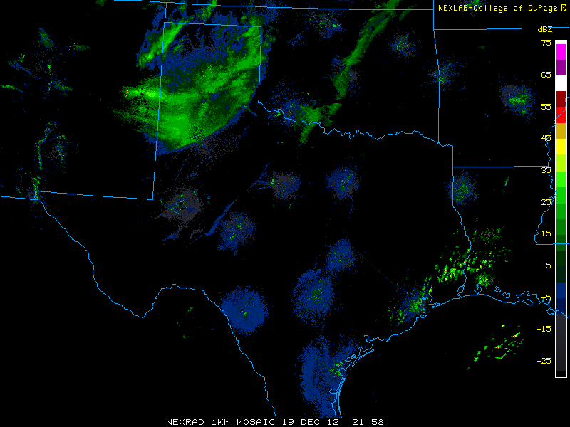
Radar echoes during the late morning hours depicted dust plumes originating from points north of Roswell toward Clovis. These plumes can be seen across portions of the South Plains and extreme southern Texas panhandle in the following image of radar reflectivity just before 4 pm.
|
|
 |
|
| Composite radar reflectivity image of the Southern Plains just prior to 4 pm CST on December 19th. | |
|
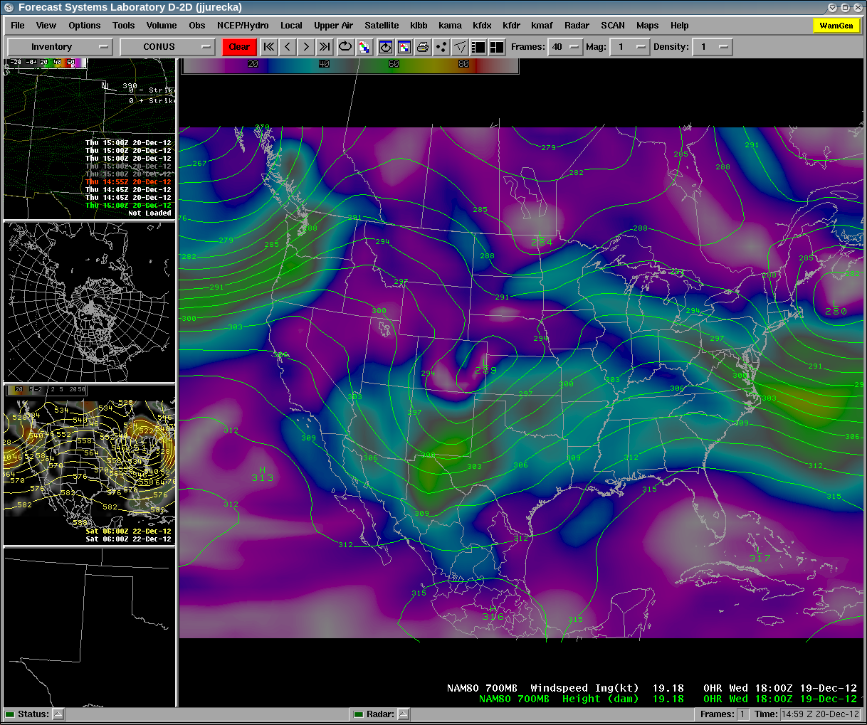
Closer to the surface, at 700mb, or near 5000 ft MSL, we can see a wind maxima around 60kts entering the area from the west. This was coincident with the higher winds seen across the western half of the area where clouds were clearing. Meteorologists at the NWS in Lubbock often use the pressure height gradient at this level as a rough approximation for the wind speeds expected at the surface. In this case, these gradients were 80-90 meters per 200 nm which yields a surface wind speed from 35 to 45 mph.
|
|
 |
|
| 700mb analysis of weather image around noon CST on December 19th | |
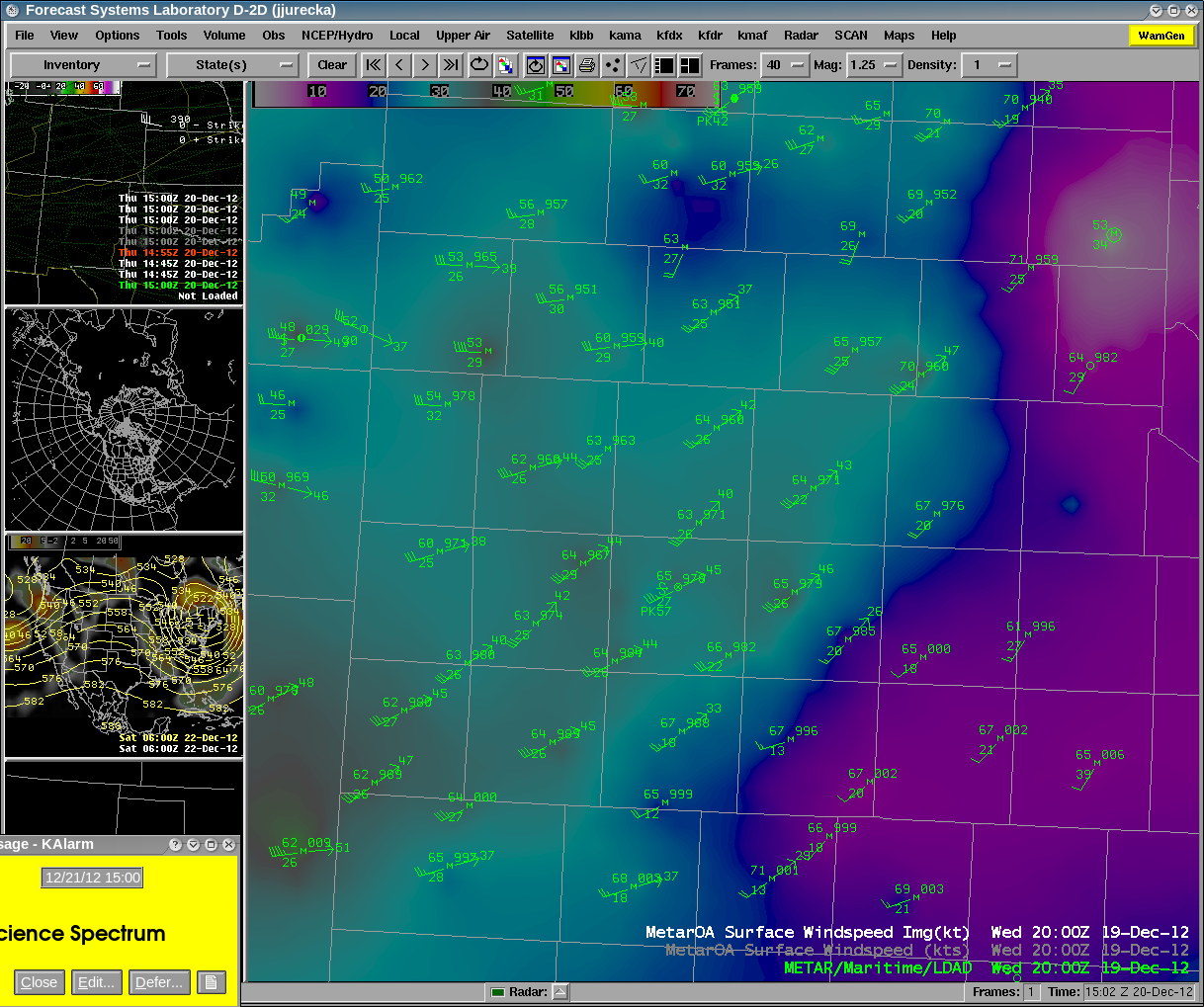
| At the surface, we can see the result of these dynamic features aloft with the resultant wind speeds. | |
 |
|
| 2 pm surface observations across West Texas. At this time, 30 to 40 kt sustained winds with higher gusts were occuring. The shading depicts wind velocities. | |
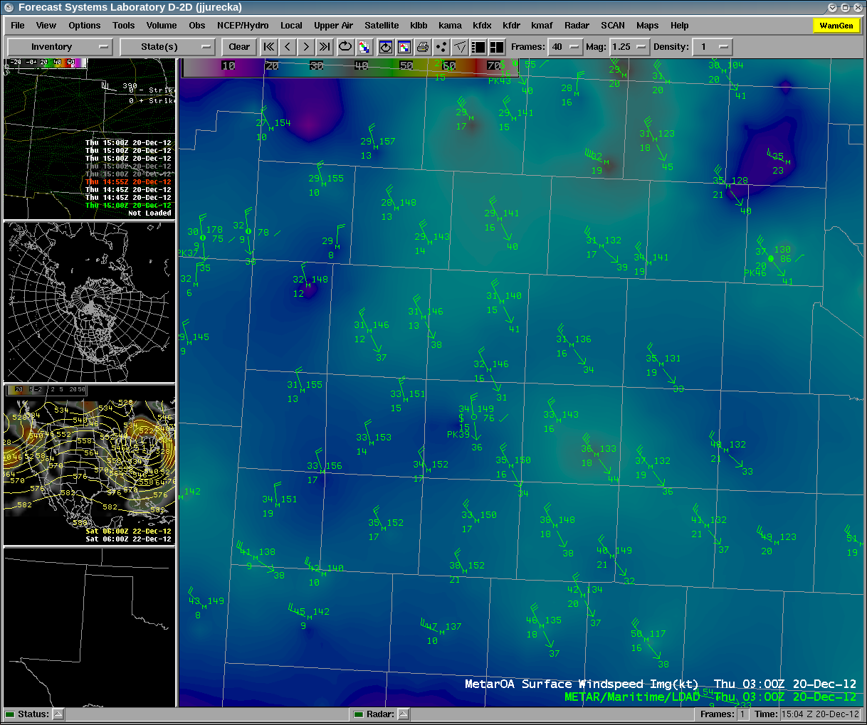
| During the afternoon, the Pacific front rapidly pushed east through the area. Other than dropping temperatures about 10 degrees and shifting the winds to more of a west-northwesterly direction, little change was noted by residents across the region. However, late in the afternoon, a fast moving cold front moved in from the north triggering snow across the northern Texas and Oklahoma Panhandles. The image below shows the surface observations and wind speeds. Wind speeds decreased about 10-15 kts behind the front, but also quickly dropped temperatures. Winds behind the front stayed up overnight due to a tight pressure gradient across the area. | |
 |
|
| 8 pm surface observations across West Texas. At this time, 25 to 30 kt sustained winds with higher gusts were occuring. The shading depicts wind velocities. | |
|
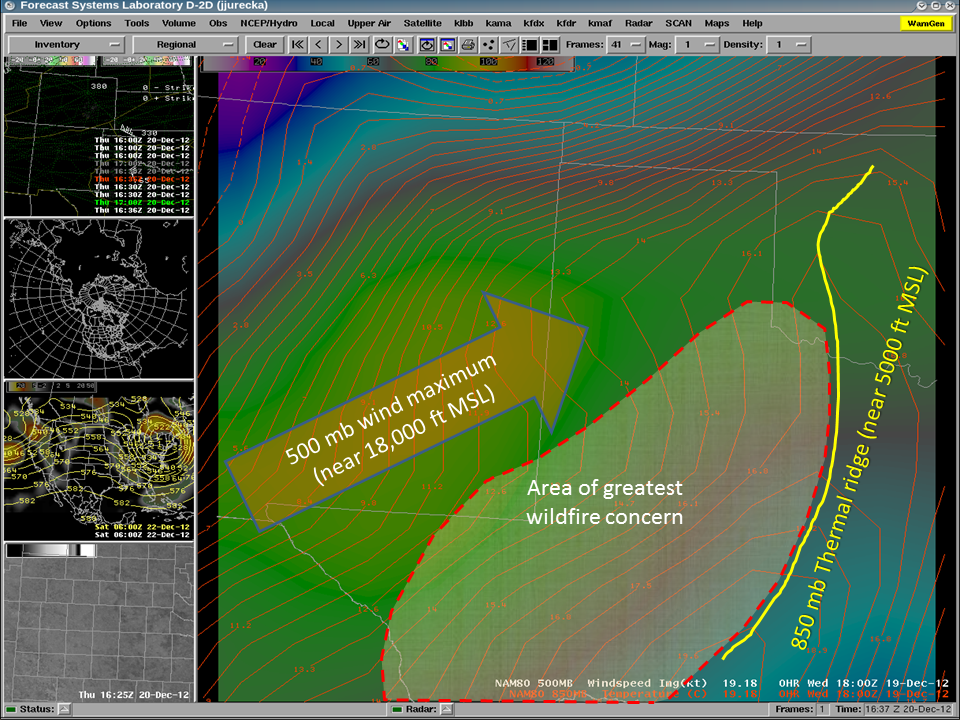
From a fire weather perspective, this event was not anticipated to be a significant event like we experienced last year. First, while fuel energy release component values were on the rise, there is not nearly the quantity of fuels (grass) that existed in early 2011. Second, NWS forecasters in West Texas have determined, through careful study of previous fire events, that the highest danger for large grassfires tends to exist in the region between the 500mb wind max and the 850 mb thermal ridge. The location of these two features are outlined in the area below along with the area of greatest risk. This area was expected to experience lighter winds during the period of the day when the humidity was lowest (and also under cloud cover.) Third, surface humidity values were 10 to 15 percent higher than those typically required for outbreak-type fire weather days. There were a few wildfires reported across the area triggered by downed power lines, but no signifcant fire reports have been received as of this writing.
|
|
 |
|
| 500 mb winds and 850 mb temperatures around noon CST December 19th | |
|
Without question, many people will long remember the dust storm of December 19th, 2012. It was a significant event from a generational timeframe perspective. But, it is also important to note that events such as this are not unprecendented. Many intense dust storms were observed in the 1930s, 1950s, and some in the 1970s. Agricultural practices have reduced to the frequency of large dust storms as compared to what was seen in the 1930s. Eastern New Mexico has far less farming yet significant dust regions exist. So, agriculture, while a contributor to the dust, is not the sole cause. To further put this event into perspective, the last 300 to 500 years have been anomalously wet across West Texas compared to longer term historical perspectives. This is a dry region, near 30 degrees north, a region of the globe that naturally trends toward hot and dry conditions. Periodic dust storms have been a fact of life in this region and this will continue to be the case in the future. |
|
| The map below shows some of the peak wind reports from the event: | |
|
Wind reports from the West Texas Mesonet and National Weather Service on 19 December 2012. Click on the image to view a larger version. |
|
| West Texas Mesonet Daily Summary Data: | |
| Click HERE to view the summay data for 12/19/2012 | |
| Preliminary Local Storm Reports: | |
|
Click HERE to view the local storm reports from this event |
|