National Weather Service United States Department of Commerce


 More Heavy Rain and Snow

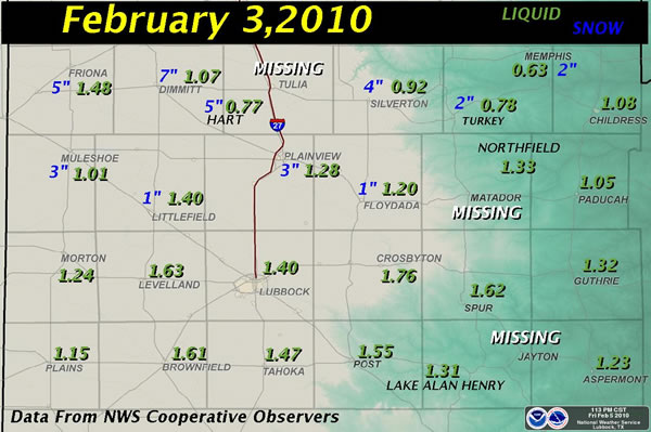
Graphic displaying the amount of rain (green) and snow (blue) observed from the February 3rd storm.  Amounts are in inches. Click on the image for a larger view.

Graphic displaying the amount of rain (green) and snow (blue) observed from the February 3rd storm.  Amounts are in inches. Click on the image for a larger view.


Another moisture-rich storm system, the second in a week, affected West Texas on Wednesday, February 3, 2010. Similar to the prior system on January 28th, the precipitation started out as a chilly rain across the area, with even a little freezing rain across the northern sections. However, unlike the previous week's storm, colder air was slower to advance into the area, which kept rain as the primary mode from the central South Plains into the Rolling Plains. Still, it did become just cold enough for the rain to change to snow for some, initially across the southwest Panhandle by around midday, and then into portions of the South Plains by late afternoon and evening.

Before the winter storm was all said and done, it provided the region with another round of beneficial precipitation. The above graphic shows that most locations recorded anywhere from an inch to an inch and a half of liquid, with even a few slightly higher amounts over the central and southern South Plains. Additionally, the southern Panhandle into the northern South Plains saw widespread 2 to 5 inch snows, with locally heavier amounts. Dimmitt was the snowfall winner, reporting 7 inches.

To view the public information statement issued regarding this event CLICK HERE.  To read the local storm report referencing the snow CLICK HERE.

 
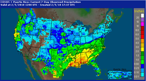
 Imaging depicting the 7-day observed precipitation across the United States ending at 6 am CST on February 5, 2010. Click on the image for a larger view.

Imaging depicting the 7-day observed precipitation across the United States ending at 6 am CST on February 5, 2010. Click on the image for a larger view.


The generous precipitation was not confined to West Texas, as the above image illustrates. This storm system also brought widespread moderate to heavy precipitation to most of the southern United States east of the Rocky Mountains, with the 7-day total precipitation through 6 am February 5th indicating a large swath in excess of 2 inches from southeast Texas through Alabama and portions of Georgia and the Carolinas. This same storm system was also responsible for heavy snow in the mid-Atlantic. 

 
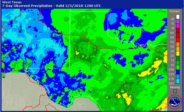
 Graphic showing the 7-day observed precipitation across western Texas, western Oklahoma and eastern New Mexico ending at 6 am CST on February 5, 2010. Click on the image for a larger view.

Graphic showing the 7-day observed precipitation across western Texas, western Oklahoma and eastern New Mexico ending at 6 am CST on February 5, 2010. Click on the image for a larger view.


The above map shows a closer view of the total 7-day precipitation that fell in and around West Texas. The recent wet storm systems have pushed the region well above normal for the year. Through February 4th, the Lubbock airport had measured 2.87 inches for the year, which was 2.29 inches above the average of 0.58 inches. Lubbock also had officially received 8.7 inches of snow since December 1st, which was 2.9 inches above the normal of 5.8 inches. The story was comparable at Childress where they were 1.72 inches above normal for the year, with 2.40 inches of liquid equivalent having fallen through February 4th.