 |
|
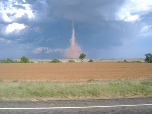
Image of a landspout tornado captured by a KCBD viewer on September 27, 2007. The tornado formed with a storm located west of Cotton Center in Hale County. (Image courtesy of KCBD)
|
The combinations of a warm and unstable airmass and numerous convergent boundaries were enough to generate a number of strong storms during the afternoon and evening of Thursday, September 27, 2007. The stronger storms brought large hail and high winds to a number of locations both on the Caprock and off, with even one tornado produced west of Cotton Center. The larger hail reports generally topped out around one inch in diameter, though one storm did produce golf ball size hail near Kirkland in Childress County, while the stronger winds blew some larger tree limbs and tents down in the Guthrie area.
The tornado that occurred west of Cotton Center developed under a rapidly growing storm. This storm updraft was present above a surface convergent boundary that already possessed some spin. As this spinning air near the ground was stretched rapidly upward it was able to form a landspout tornado. Since these type of tornadoes have their origin near the ground, often before there is much of a visible storm on radar, they are very difficult to detect by radar. This is in contrast to the more widely understood supercellular tornado which forms from a well developed rotating storm that can be interrogated much more readily by radar. Regardless, both methods can generate a tornado. Although the supercell tornadoes are responsible for the very strongest (and often most deadliest) tornadoes on the earth, landspout tornadoes must too be respected. Thankfully, though tough to detect by radar, often times landspout tornado can be visible from long distances and from many or all directions because they form near the beginning of a thunderstorm lifecycle before there is much rain and hail falling from the cloud to obscure their view. Thus, spotters can be very effective in detecting such hazards.
The following images show a number of different views of the landspout tornado that formed with a storm located west of Cotton Center in Hale County. Please click on each image to see a larger version. (Images courtesy of KCBD)
|
|
|
The below images show field flooding and hail associated with the storm in western Hale County on September 27, 2007. Please click on each image to see a larger version. (Images courtesy of KCBD)
|
|
|
Although landspout tornado events can be somewhat unusual, they are certainly not unheard of across the South Plains. In fact, there was another more prolific such event just earlier this year, on March 25. To read about the March 25, 2007 landspout tornado event CLICK HERE.
Additionally, if you would like to view the preliminary local storm reports for the September 27 event CLICK HERE.