Lubbock, TX
Weather Forecast Office
Soaking Rains Hit the South Plains Region
8 -10 May 2007
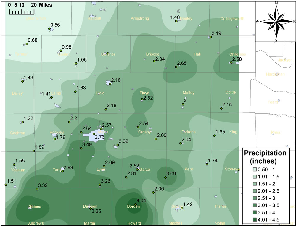
Above is an image displaying the rainfall totals (inches) that fell between 8 May and 6 pm on 10 May 2007. Additionally, plotted on top of the image are the observed rainfall amounts that were recorded by the West Texas Mesonet and the National Weather Service. Click on the image for a larger view.
A persistent upper level storm system combined with abundant amounts of moisture to bring a couple of rounds of moderate to heavy rains across the South Plains region. Rainfall amounts for the Lubbock International Airport over the two day period (8-9 May 2007) reached 2.56 inches. This two day total exceeded the normal monthly rainfall of the entire month of may by exactly a quarter inch.
Also of note is the rainfall total for the Lubbock International Airport for the time period from January through May. The total rainfall through 15 May 2007 stood at 11.54 inches. This ranks as the 5th wettest start to the year since records began in 1911. The following are the top 6 wettest January through May periods for Lubbock:
1. 1941 19.64
2. 1949 14.78
3. 1915 13.31
4. 1957 11.70
5. 2007 11.54
6. 1992 11.20
A listed of the compiled three day rainfall totals (from 8 May through 6 pm on 10 May 2007) can be found HERE.

US Dept of Commerce
National Oceanic and Atmospheric Administration
National Weather Service
Lubbock, TX
2579 S. Loop 289
Suite 100
Lubbock, TX 79423-1400
806-745-3916
Comments? Questions? Please Contact Us.


 Follow us on X
 Follow us on Facebook
 Follow us on YouTube
 LUB RSS Feed


