Lubbock, TX
Weather Forecast Office
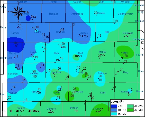
| Image of the low temperatures (°F) observed across the region on November 16, 2005. The above image was created with data from the Texas Tech West Texas Mesonet and from the NWS COOP network. County names are also displayed. |
A cold Canadian airmass that moved in quickly on the heels of a strong cold front allowed for very cold temperatures across the entire region Wednesday morning (November 16, 2005). The combination of clear skies, very dry air, and light winds resulted in nearly ideal radiational cooling conditions. This meant cool morning lows, with most locations falling well below 28 °F for an extended period.
Additionally, the cool morning resulted in the first freeze of the season for those locations that had not already experienced one (generally across the Southern South Plains and portions of the Rolling Plains). The Lubbock International Airport officially fell to the 32 degree mark for the first time this fall at 8:27 pm on Tuesday, November 15. This was well after the average freeze date of October 31.

US Dept of Commerce
National Oceanic and Atmospheric Administration
National Weather Service
Lubbock, TX
2579 S. Loop 289
Suite 100
Lubbock, TX 79423-1400
806-745-3916
Comments? Questions? Please Contact Us.


 Follow us on X
 Follow us on Facebook
 Follow us on YouTube
 LUB RSS Feed


