
A winter-like pattern will continue over much of the Lower 48 over the next few days, with snow stretching from the Rockies today into the Middle Mississippi Valley on Monday. Showers and thunderstorms will develop along the Gulf Coast and Southeast on Monday. As the storm moves northward late Monday into Tuesday, winter weather is possible from the Central Appalachians to Interior New England. Read More >
Overview
|
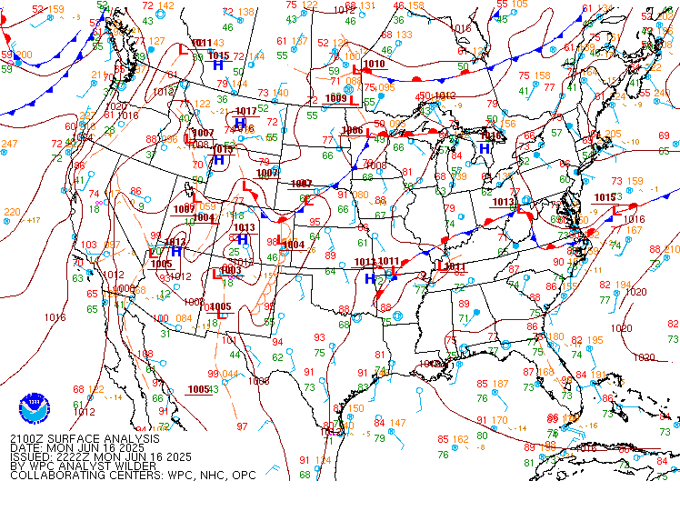
An area of low pressure moved from eastern South Dakota to Lake Superior on the 16th. As the low tracked to the northeast, it lifted a warm front into central Minnesota. To the south of the warm front and to the east of a cold front, a very warm and moist unstable airmass was in place. Morning thunderstorms across the region left cloud cover in place over much of the Northland, but areas of clearing were able to develop in the vicinity of the low across the central part of the state. This heating led to rapid destabilization and the development of low-topped supercells in central Minnesota. Low level winds were strong and somewhat veered leading to a good environment for tornadoes early in a storm's lifecycle.
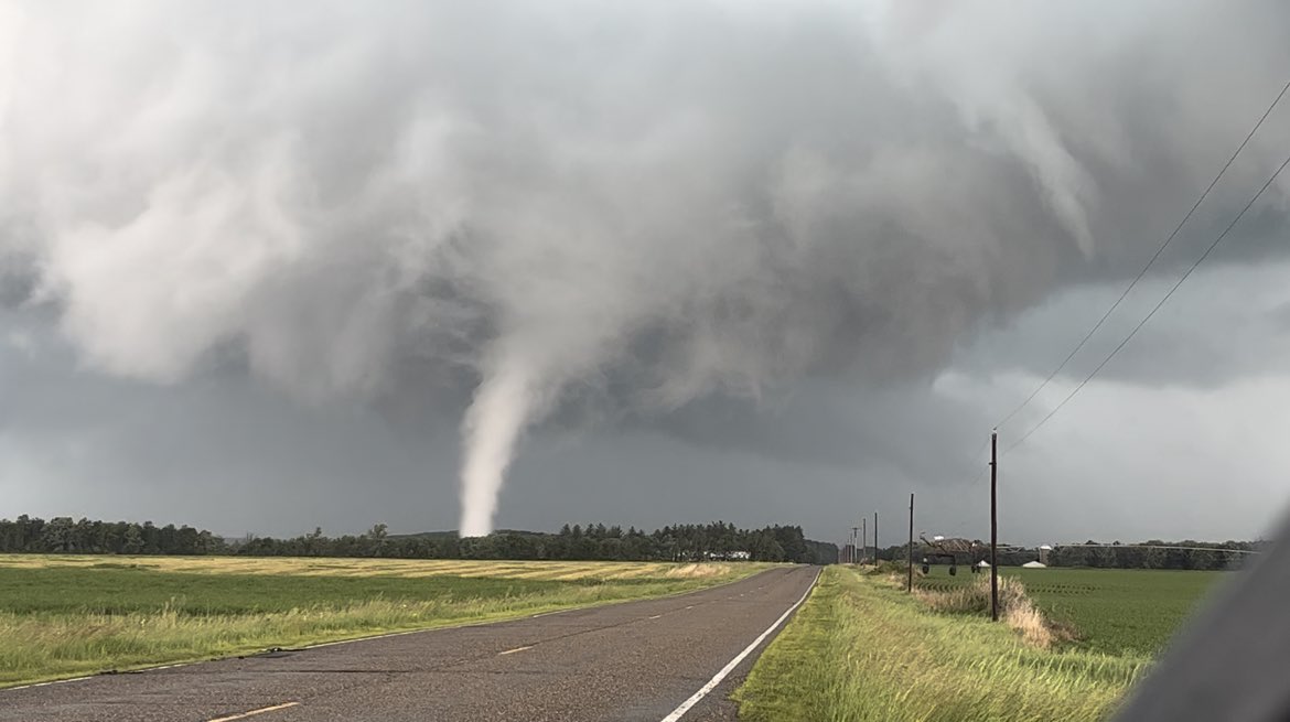
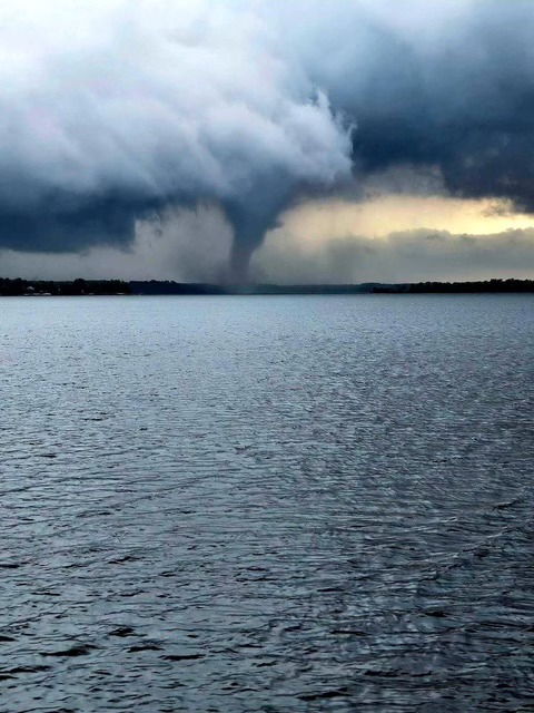
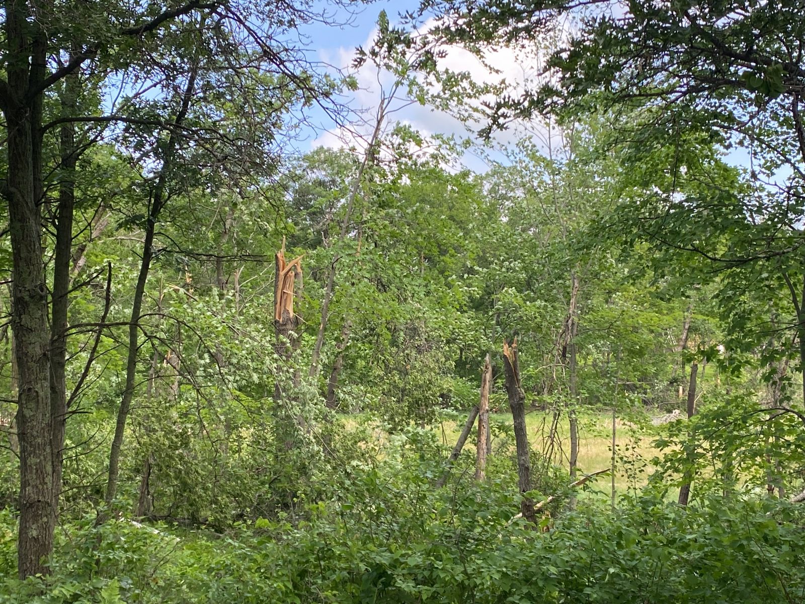
As a broken line of storms moved in to the Brainerd Lakes area, one storm produced a large EF-1 tornado that began near Casino and moved over Gull Lake before dissipating shortly after moving back onto land near Minnesota Highway 371 just north of Brainerd. This tornado was well documented by chasers in the area. The storm cycled and produced another EF-1 tornado that touched down to the west of Merrifield and moved to the east through the northern part of town and into an inaccessible area along the Mississippi River before ended in Cuyuna State Park along the north shore of Huntington Mine Lake. Extensive tree damage was observed with both tornadoes with many being snapped some ten to 20 feet above the ground. Other areas of tree damage were reported as the line of storms progressed to the east, but no additional tornadoes were found. Some minor flash flooding was reported across the Iron Range as well with this activity.
|
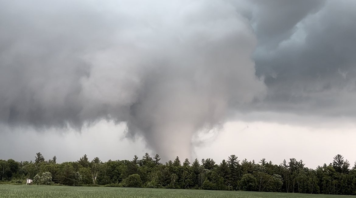 A view of the Casino tornado not too long after touching down. Photo courtesy of Ben Williams. |
Tornadoes
Select a tornado from the table to zoom into the track and view more information. The default table view is limited to 8 tracks, but can be scrolled by a mouse wheel or dynamically expanded. Additionally, the table can fill the entire window by clicking the small circular expanding arrow icon at the very top right of the table and returned to its original size by clicking the button again. The side information panel that opens over the map can be closed using the "X" on the upper right corner of the pop-up. Zoom into the map and click damage points to see detailed information and pictures from the surveys.
|
NOTE: times shown below are local to your device's time zone. |

The Enhanced Fujita (EF) Scale classifies tornadoes into the following categories:
| EF0 Weak 65-85 mph |
EF1 Moderate 86-110 mph |
EF2 Significant 111-135 mph |
EF3 Severe 136-165 mph |
EF4 Extreme 166-200 mph |
EF5 Catastrophic 200+ mph |
 |
|||||
| Tornadoes that fail to impact any ratable damage indicators on the EF-Scale are rated EF-Unknown (EF-U) | |||||
Photos & Videos
Photos
 |
 |
 |
| Another early view of the Casino tornado. (Ben Williams photo) |
The Casino tornado as it began to cross Gull Lake between Nisswa and Brainerd. (Tom Whitehead photo) |
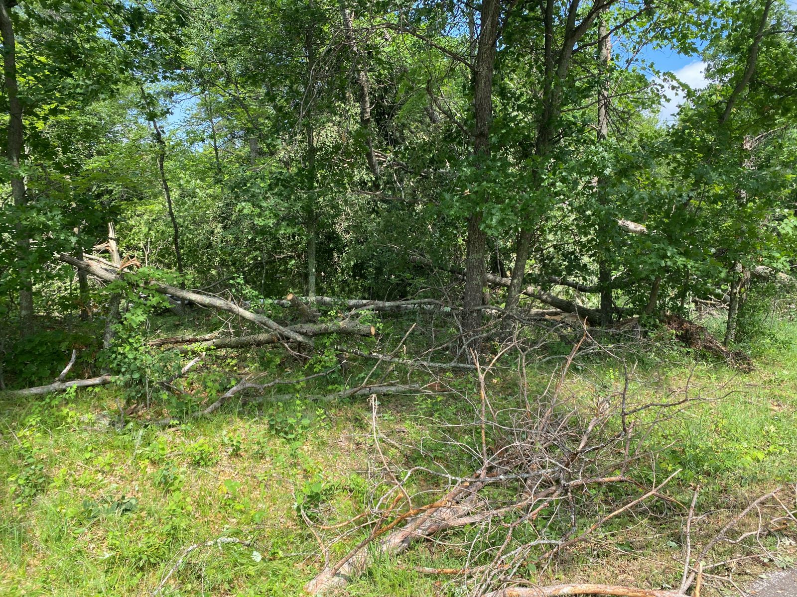
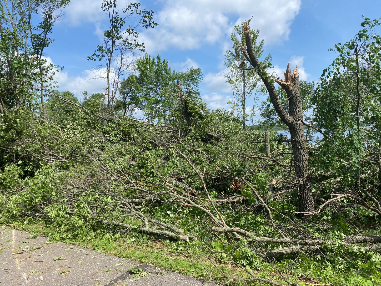
Tree damage from the tornado near Merrifield. Much of the damage was similar to this with trees being snapped about 10 to 20 feet above the ground. (NWS photo) |
 |
 |
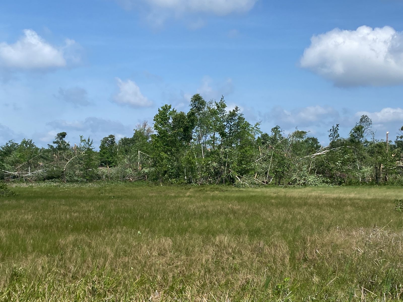 |
| Tree damage from the tornado near Merrifield. Much of the damage was similar to this with trees being snapped about 10 to 20 feet above the ground. (NWS photo) |
Tree damage from the tornado near Merrifield. Much of the damage was similar to this with trees being snapped about 10 to 20 feet above the ground. (NWS photo) |
Tree damage from the tornado near Merrifield. Much of the damage was similar to this with trees being snapped about 10 to 20 feet above the ground. (NWS photo) |
Videos
Casino, Minnesota #tornado captured by drone on Monday. It was its strongest in the trees seen here over the Pillsbury State Forest where there are absolutely zero roads. @NWSduluth has rated this an EF-1. Was a wild day across Minnesota.#minnesota #weather #mnwx @MyRadarWX pic.twitter.com/qQuJVxC4ue
— Jordan Hall (@JordanHallWX) June 19, 2025
Radar
 |
 |
 |
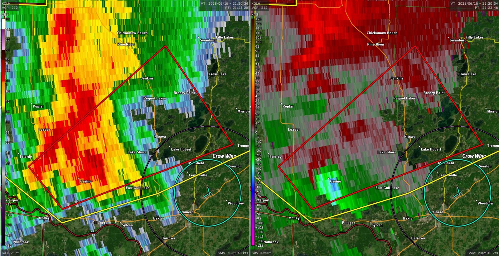
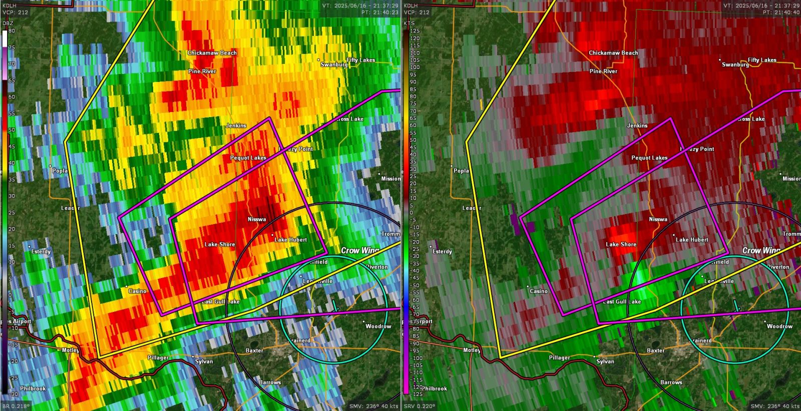
| KDLH Reflectivity (Z) on the left and Storm-Relative Velocity (SRV) on the right at 4:23PM, just after the tornado formed. A cell merger had just occurred and the tornado developed quite quickly with very strong vorticity present in the low levels. (NWS photo) |
KDLH Reflectivity (Z) on the left and Storm-Relative Velocity (SRV) on the right at 4:40PM, as the tornado was moving over Gull Lake near Nisswa. It would lift just past the eastern shore of the lake before reaching SR 371. (NWS photo) |
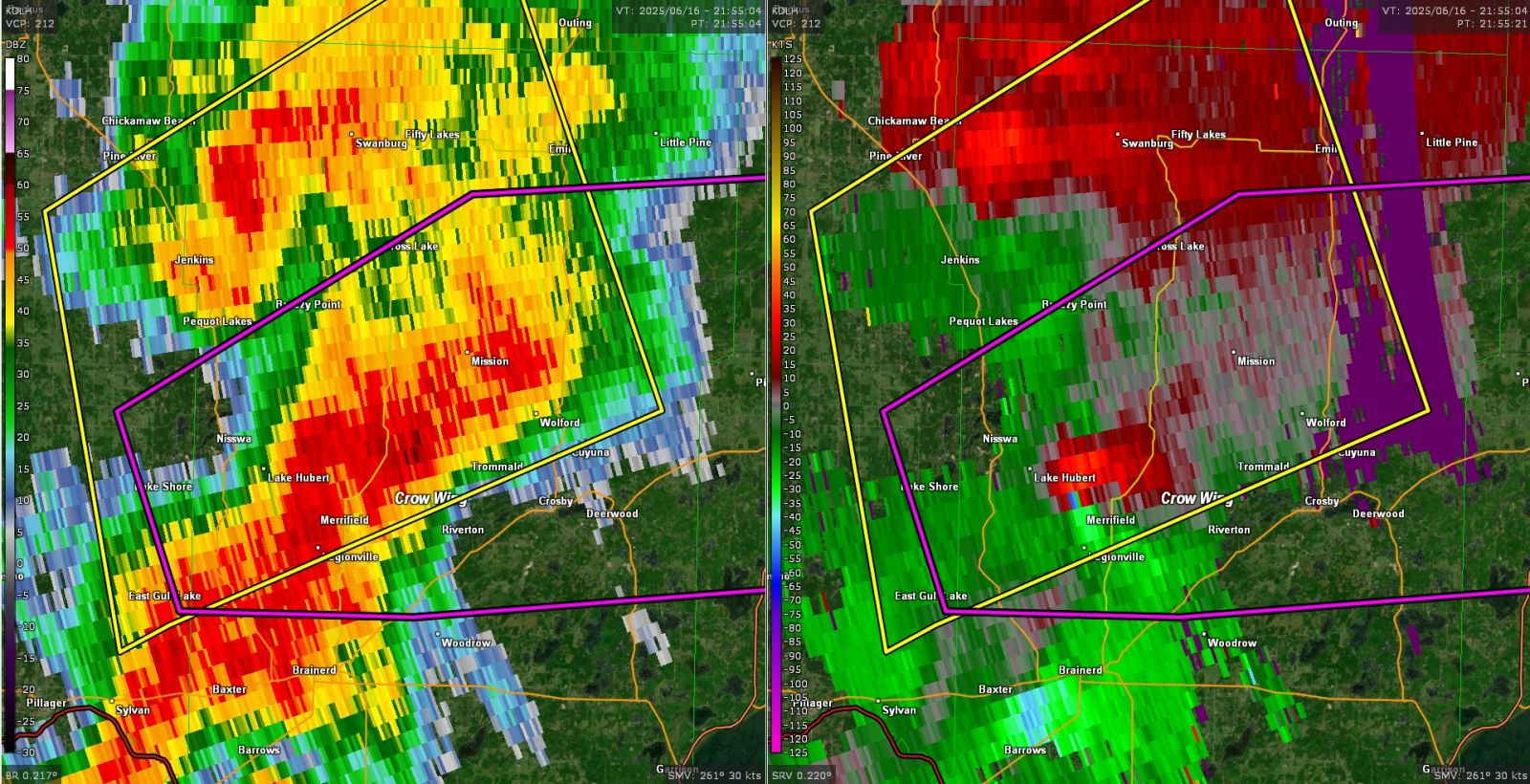
KDLH Reflectivity (Z) on the left and Storm-Relative Velocity (SRV) on the right at 4:55PM, about 10 minutes after the second tornado had formed west of Merrifield. This was a rain-wrapped tornado as evidenced by the rotation being embedded in the strong reflectivity and from photos that were received from Merrifield. (NWS photo) |
Storm Reports
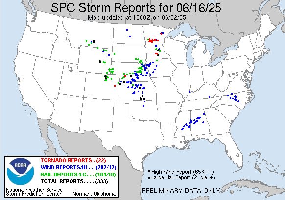
Click the image above for Storm Reports from around the country.
View a Local Storm Reports map here: https://www.mesonet.agron.iastate.edu/lsr/?by=wfo&wfo=KDLH&sts=202506160500&ets=202506170500&settings=0110100.
..TIME...   ...EVENT...      ...CITY LOCATION...     ...LAT.LON...
..DATE...   ....MAG....      ..COUNTY LOCATION..ST.. ...SOURCE....
            ..REMARKS..

0436 PM     Hail             Lake Shore              46.50N 94.36W
06/16/2025  M0.70 Inch       Cass               MN   Trained Spotter


0440 PM     Hail             1 NNE Lake Shore        46.51N 94.35W
06/16/2025  M1.25 Inch       Cass               MN   Public

            Photo was received showing larger than
            quarter-sized hail.

0442 PM     Hail             1 NNW Lake Shore        46.51N 94.37W
06/16/2025  M1.00 Inch       Cass               MN   Trained Spotter


0450 PM     Tstm Wnd Dmg     1 NW Merrifield         46.47N 94.19W
06/16/2025                   Crow Wing          MN   Public

            Many trees down. Some uprooted and some
            snapped anywhere from 10 to 20 ft. Plastic
            chair flung into and broken onto and around
            a tree trunk. Time estimated from radar.

0450 PM     Tstm Wnd Dmg     Merrifield              46.47N 94.17W
06/16/2025                   Crow Wing          MN   Public

            Several pictures received of downed trees
            that appeared to be a combination of snapped
            and uprooted...a business sign...and fence
            damage due to strong thunderstorm winds at
            the intersection of County Road 127 and 3 in
            Merrifield MN. There was also similar damage
            such as trees down over a roadway about one
            quarter mile north of this intersection.

0458 PM     Tstm Wnd Dmg     1 N Merrifield          46.48N 94.17W
06/16/2025                   Crow Wing          MN   Trained Spotter

            Trees fallen in multiple directions at the
            location. Time estimated from radar.

0613 PM     Flash Flood      Kelly Lake              47.42N 93.01W
06/16/2025                   St. Louis          MN   Public

            Facebook photo received of water covering a
            road intersection and nearby grassy
            surfaces. Estimated depth was 6 inches.

0617 PM     Tstm Wnd Dmg     Hibbing                 47.42N 92.95W
06/16/2025                   St. Louis          MN   Public

            Around an 8 inch diameter pine tree down.
            Multiple other branches down. Time estimated
            by radar.

0628 PM     Tstm Wnd Dmg     1 NNW Virginia          47.54N 92.54W
06/16/2025                   St. Louis          MN   Public

            Large limb broken off mature tree. Time
            estimated from radar.

0630 PM     Tstm Wnd Dmg     1 NNW Virginia          47.54N 92.54W
06/16/2025                   St. Louis          MN   Public

            Large tree branch broken off mature tree,
            several inches in diameter. Photo via social
            media. Time estimated.

0700 PM     Flash Flood      Calumet                 47.32N 93.28W
06/16/2025                   Itasca             MN   Law Enforcement

            Report of water over the roadway at the
            intersection of US-169 and Gary Street from
            earlier in the evening. Time is estimated by
            radar. As of midnight, the flooding had
            receded.

0730 PM     Flash Flood      Hibbing                 47.42N 92.94W
06/16/2025                   St. Louis          MN   Public

            Storm sewer system overwhelmed- water
            spraying up through manhole cover. Water
            ponded around manhole. Via Social Media.
            Time Estimated.

0730 PM     Flash Flood      1 NNE Eveleth           47.48N 92.53W
06/16/2025                   St. Louis          MN   NWS Storm Survey

            Water over Old Highway 53, and minor washout
            of road surface. Time estimated.

0747 PM     Flash Flood      1 SW Virginia           47.51N 92.55W
06/16/2025                   St. Louis          MN   Public

            Public report relayed via emergency
            management of water coming quickly into the
            basement of a house on 10th Street South in
            the city of Virginia.

0750 PM     Flash Flood      1 NNE Eveleth           47.48N 92.53W
06/16/2025                   St. Louis          MN   Public

            In Eveleth, where 53 is being rerouted down
            the little road behind Lundgrens, the road
            was not only flooded over but the current
            was so strong (coming down that hill) that
            the tires of my car started to slip. Time
            estimated from MRMS FLASH CREST Unit
            Streamflow signature.

0800 PM     Flash Flood      Virginia                47.52N 92.54W
06/16/2025                   St. Louis          MN   Public

            Flooded street, with water up to the rims of
            an SUV 3 to 5 inches deep. Time and location
            estimated. Via Social Media.

0800 PM     Flash Flood      1 ESE Hibbing           47.41N 92.92W
06/16/2025                   St. Louis          MN   Public

            Flooded streets above curbs on the east side
            of Hibbing. Via social media.

0830 PM     Flash Flood      1 NNE Eveleth           47.48N 92.53W
06/16/2025                   St. Louis          MN   Public

            Report of a flooded roadway behind Lundgren
            Motors in Eveleth. Report was received via
            Facebook. Time is approximate between 830 PM
            and 845 PM. Location is approximate.


&&

$$
Rain Reports
823
NOUS43 KDLH 171125
PNSDLH
MNZ010>012-018>021-025-026-033>038-WIZ001>004-006>009-172325-

Public Information Statement
National Weather Service Duluth MN
625 AM CDT Tue Jun 17 2025

...24-HOUR PRECIPITATION REPORTS (1 INCH OR GREATER) AS OF 6:20 AM
6/17/2025...

Location                     Amount    Time/Date       Lat/Lon
Mountain Iron 2.0 ESE        4.58 in   0515 AM 06/17   47.51N/92.59W
2 W Iron Junction            4.00 in   0950 PM 06/16   47.42N/92.65W
Iron Junction 3.4 NNW        3.91 in   0345 AM 06/17   47.46N/92.63W
NASHWAUK                     3.27 in   1109 PM 06/16   47.53N/93.19W
Aurora 0.6 SSE               3.00 in   0550 AM 06/17   47.52N/92.24W
3 W Leonidas                 3.00 in   0810 PM 06/16   47.46N/92.63W
Seagull Lake RAWS            2.72 in   0604 AM 06/17   48.12N/90.84W
16 N Grand Marais - Superior 2.71 in   0539 AM 06/17   48.02N/90.14W
10 NE Deer River             2.70 in   0700 PM 06/16   47.43N/93.64W
KEEWATIN                     2.63 in   0610 AM 06/17   47.40N/93.08W
Superior Qd No. 4            2.60 in   0542 AM 06/17   47.98N/90.36W
Embarrass                    2.49 in   0600 AM 06/17   47.66N/92.20W
Eveleth                      2.48 in   0609 AM 06/17   47.29N/92.55W
Ely RAWS                     2.41 in   0604 AM 06/17   47.83N/91.84W
Chisholm-Hibbing Airport     2.36 in   1053 PM 06/16   47.38N/92.83W
Ely RAWS                     2.33 in   1104 PM 06/16   47.83N/91.84W
Hibbing RAWS                 2.30 in   0607 AM 06/17   47.39N/92.83W
1 NE Hibbing                 2.27 in   0615 AM 06/17   47.42N/92.93W
Superior Qd No. 2            2.25 in   0539 AM 06/17   47.66N/92.61W
8.4 E Babbitt                2.23 in   0530 AM 06/17   47.69N/91.76W
Winton                       2.21 in   0610 AM 06/17   47.98N/91.43W
Hog Creek                    2.19 in   0518 AM 06/17   47.80N/90.95W
Eveleth-Virginia Airport     2.17 in   0615 AM 06/17   47.42N/92.50W
Embarrass                    2.16 in   1000 PM 06/16   47.66N/92.20W
Chippewa Port No. 1          2.16 in   1059 PM 06/16   47.40N/94.36W
Eveleth-Virginia Airport     2.15 in   1055 PM 06/16   47.42N/92.50W
Chippewa Port No. 1          2.15 in   0559 AM 06/17   47.40N/94.36W
Winton                       2.13 in   1110 PM 06/16   47.98N/91.43W
Meander RAWS                 2.08 in   0604 AM 06/17   48.12N/92.16W
Deer River 6.5 S             2.05 in   0600 AM 06/17   47.25N/93.81W
3.1 SW Embarrass             2.01 in   0600 AM 06/17   47.63N/92.24W
Grand Marais                 1.97 in   0600 AM 06/17   48.14N/90.87W
Aurora                       1.92 in   0600 AM 06/17   47.52N/92.24W
Seagull Lake RAWS            1.90 in   1104 PM 06/16   48.12N/90.84W
Fernberg RAWS                1.86 in   0513 AM 06/17   47.95N/91.50W
3.1 SW Embarrass             1.84 in   1000 PM 06/16   47.63N/92.24W
Aurora                       1.80 in   1100 PM 06/16   47.52N/92.24W
8.4 E Babbitt                1.78 in   1030 PM 06/16   47.69N/91.76W
Superior Qd No. 4            1.76 in   1042 PM 06/16   47.98N/90.36W
16 N Grand Marais - Superior 1.74 in   1039 PM 06/16   48.02N/90.14W
Grand Portage                1.69 in   0600 AM 06/17   47.97N/89.69W
Grand Marais                 1.63 in   1100 PM 06/16   48.14N/90.87W
8 E Boy River - Chip Port No 1.63 in   0559 AM 06/17   47.18N/93.96W
Grand Portage RAWS           1.57 in   0544 AM 06/17   47.95N/89.78W
GRAND RAPIDS                 1.55 in   0610 AM 06/17   47.22N/93.52W
Hoyt Lakes 3.0 SSW           1.52 in   0600 AM 06/17   47.52N/92.13W
GRAND MARAIS                 1.48 in   0605 AM 06/17   47.82N/90.11W
Fernberg RAWS                1.44 in   1013 PM 06/16   47.95N/91.50W
3.4 SE Little Swan           1.44 in   0545 AM 06/17   47.25N/92.81W
Grand Marais                 1.42 in   0609 AM 06/17   47.75N/90.44W
4.4 SE Babbitt               1.40 in   1000 PM 06/16   47.67N/91.86W
3.7 SE Celina                1.35 in   0545 AM 06/17   47.82N/93.02W
5.9 N Brevik                 1.34 in   1030 PM 06/16   47.17N/94.29W
4.4 SE Babbitt               1.34 in   0500 AM 06/17   47.67N/91.86W
5.9 N Brevik                 1.34 in   0530 AM 06/17   47.17N/94.29W
3.7 SE Celina                1.33 in   1045 PM 06/16   47.82N/93.02W
Remer 8.8 SW                 1.31 in   0600 AM 06/17   46.98N/94.07W
Hog Creek                    1.30 in   1018 PM 06/16   47.80N/90.95W
Skibo RAWS                   1.30 in   0522 AM 06/17   47.49N/91.99W
Grand Marais 4.4 W           1.28 in   0530 AM 06/17   47.75N/90.44W
1.8 E Cohasset               1.27 in   0515 AM 06/17   47.25N/93.59W
3.8 E Embarrass              1.27 in   0600 AM 06/17   47.67N/92.12W
Chisholm-Hibbing Airport     1.26 in   0553 AM 06/17   47.38N/92.83W
Colvin Creek nr Hoyt Lakes   1.21 in   0545 AM 06/17   47.53N/92.00W
Grand Rapids Airport         1.21 in   0556 AM 06/17   47.22N/93.52W
8 SSW Cohasset               1.17 in   0603 PM 06/16   47.15N/93.66W
Bay Of Grand Marais          1.14 in   0556 AM 06/17   47.75N/90.34W
Hill City 0.9 N              1.13 in   0700 PM 06/16   46.99N/93.60W
East Gull Lake               1.12 in   1015 PM 06/16   46.41N/94.35W
Skibo RAWS                   1.12 in   1022 PM 06/16   47.49N/91.99W
East Gull Lake               1.12 in   0515 AM 06/17   46.41N/94.35W
Pequot Lakes 9.8 WSW         1.11 in   0700 PM 06/16   46.54N/94.49W
Grand Rapids Airport         1.10 in   1056 PM 06/16   47.22N/93.52W
Cutfoot RAWS                 1.10 in   0604 AM 06/17   47.54N/94.05W
Lutsen                       1.08 in   0545 AM 06/17   47.64N/90.71W
Brainerd Airport             1.06 in   1053 PM 06/16   46.40N/94.13W
Brainerd Airport             1.06 in   0553 AM 06/17   46.40N/94.13W
Walker Community Center      1.05 in   0600 AM 06/17   47.15N/94.65W
Cutfoot RAWS                 1.04 in   1104 PM 06/16   47.54N/94.05W
Hill City RAWS               1.03 in   0607 AM 06/17   46.96N/93.60W
Colvin Creek nr Hoyt Lakes   1.02 in   1045 PM 06/16   47.53N/92.00W
Grand Rapids 5.0 SE          1.01 in   0745 PM 06/16   47.17N/93.47W
3.8 E Embarrass              1.01 in   1000 PM 06/16   47.67N/92.12W
Hackensack 8.9 E             1.00 in   0530 PM 06/16   46.94N/94.33W
1 WSW Side Lake              1.00 in   0638 PM 06/16   47.66N/93.04W

Observations are collected from a variety of sources with varying
equipment and exposures. We thank all volunteer weather observers
for their dedication. Not all data listed are considered official.

$$
Environment
 |
 |
 |
|
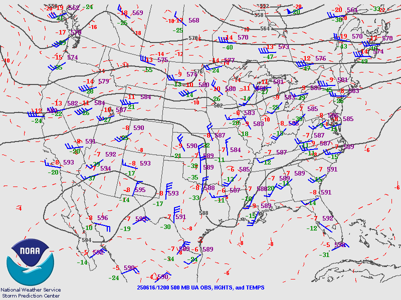
Figure 1: 500 mb heights analysis at 7AM from the Storm Prediction Center showing a shortwave trough approaching over the Northern Plains. (NWS SPC Photo) |
Figure 2: Surface analysis from the Weather Prediction Center showing a low pressure system over north-central Minnesota at 4PM, very near where the tornadoes developed. (NWS WPC Photo) |
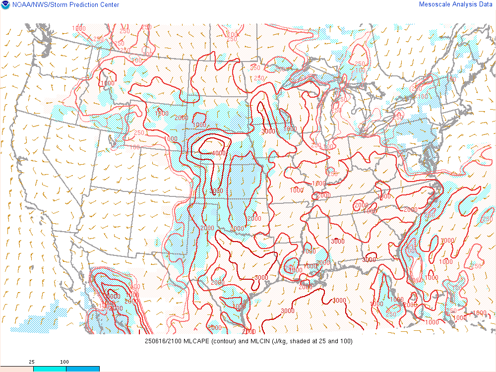
Figure 4: Mixed Layer CAPE built into central and southern Minnesota by the mid-afternoon on June 16 to aid in storm development as seen by the 16/21Z RAP Mixed Layer CAPE analysis. (NWS SPC Photo) |
 |
 |
 |
|
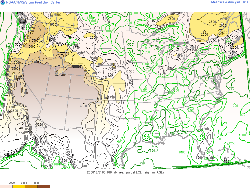
Figure 4: LCL heights of 500-750 meters, as seen in this 16/21Z RAP LCL Heights analysis, supported lower wall clouds and tornado development. (NWS SPC Photo) |
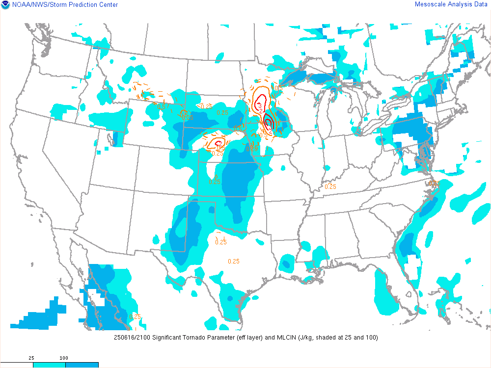
Figure 5: Enhanced values of the Significant tornado Parameter were analyzed over central Minnesota by the 16/21Z RAP analysis. (NWS SPC Photo) |
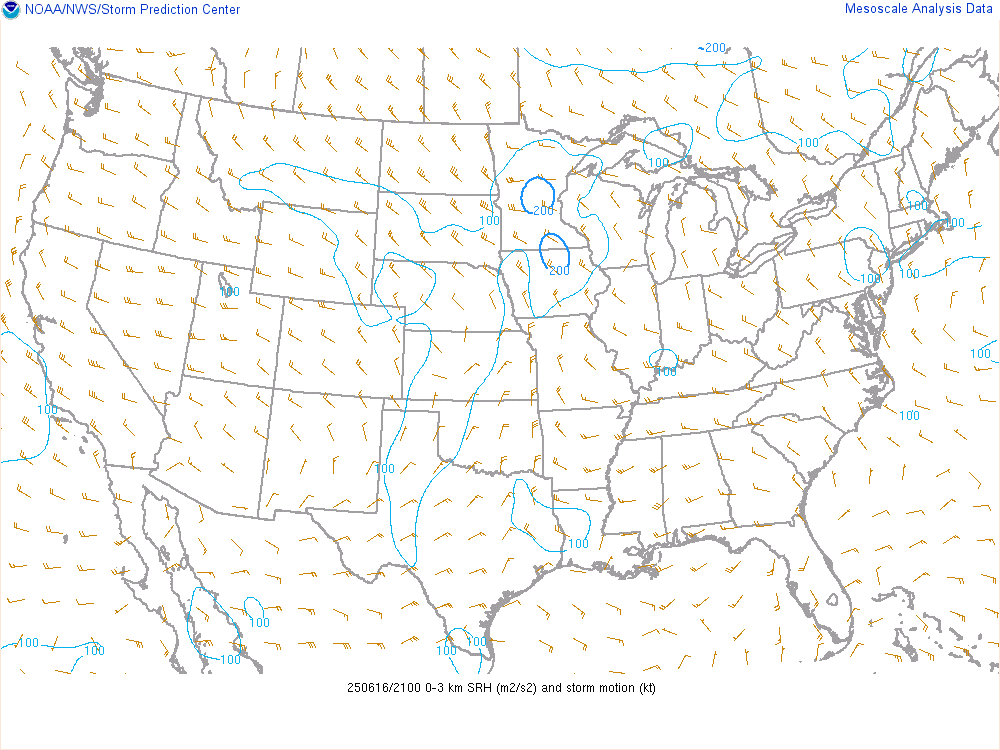
Figure 6: A pocket of enhanced 0-3km SRH was in place over central Minnesota as seen by the 16/21Z RAP analysis. (NWS SPC Photo) |
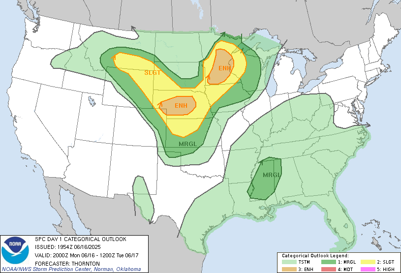
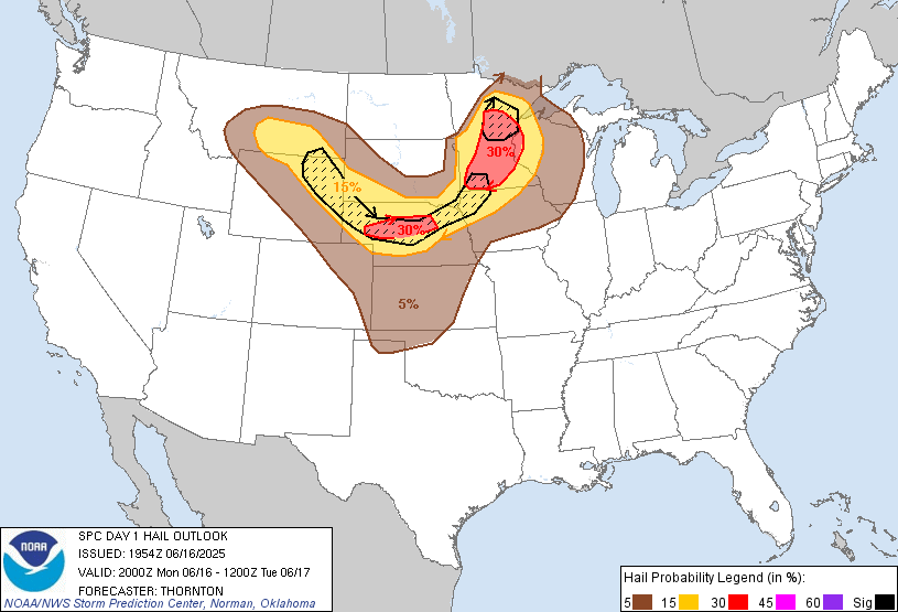
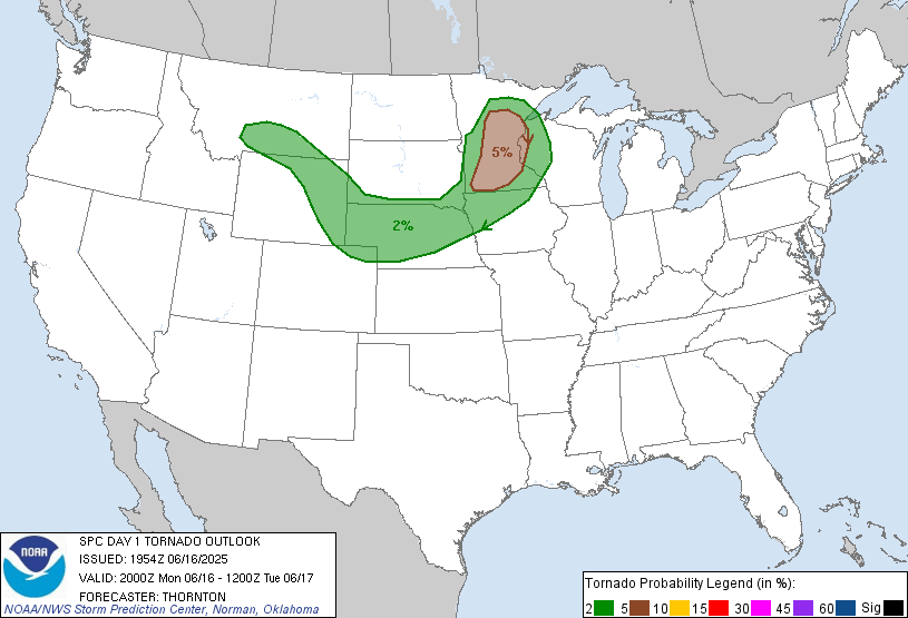
SPC Day 1 Outlooks
 |
 |
 |
 |
|
2000z Day 1 Categorical Outlook (NWS SPC Photo) |
2000z Day 1 Hail Outlook (NWS SPC Photo) |
2000z Day 1 Tornado Outlook (NWS SPC Photo) |
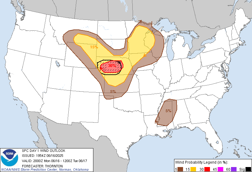
2000z Day 1 Wind Outlook (NWS SPC Photo) |
SPC AC 161954

   Day 1 Convective Outlook
   NWS Storm Prediction Center Norman OK
   0254 PM CDT Mon Jun 16 2025

   Valid 162000Z - 171200Z

   ...THERE IS AN ENHANCED RISK OF SEVERE THUNDERSTORMS THIS AFTERNOON
   AND EVENING OVER PARTS OF NEBRASKA AND PARTS OF MINNESOTA...

   ...SUMMARY...
   Scattered severe thunderstorms capable of producing severe/damaging
   gusts, large to very large hail, and a few tornadoes are forecast
   today across parts of the northern/central Plains into the Upper
   Mississippi Valley.

   ...20z Update...
   Only minor adjustments were made to trim probabilities behind the
   low/cold front in the Midwest and northern Plains. Otherwise, the
   forecast remains on track with no large changes needed.

   Scattered thunderstorm activity is expected to intensify across
   portions of MN/IA this afternoon, with potential for damaging winds,
   large hail, and a couple of tornadoes. See MCD#1311 for additional
   information.

   Across the northern Plains, a couple of supercells have developed in
   southeastern SD producing a few instances of severe hail. Additional
   development is expected across portions of NE/KS this afternoon,
   with potential for large to very large hail and damaging winds. See
   previous discussion of more information.

   ..Thornton.. 06/16/2025

   .PREV DISCUSSION... /ISSUED 1125 AM CDT Mon Jun 16 2025/

   ...MN/IA...
   Morning water vapor imagery shows a shortwave trough over the
   eastern Dakotas.  As this trough moves eastward this afternoon, a
   surface low will deepen over central MN with a trailing cold front
   sweeping across the state.  Morning convection is getting out of the
   way, which should allow several hours of strong
   heating/destabilization.  Afternoon MLCAPE values of 3000+ J/kg are
   expected, with little inhibition.  This should lead to rapid
   thunderstorm development by mid-afternoon near the surface low, with
   at least widely scattered development southward along the cold front
   into northern IA.  Low-level winds are somewhat veered but strong.
   This coupled with favorable westerly flow aloft should promote a few
   supercells capable of large hail and damaging winds.  A tornado or
   two is also possible.
SPC Mesoscale Discussions
 |
 |
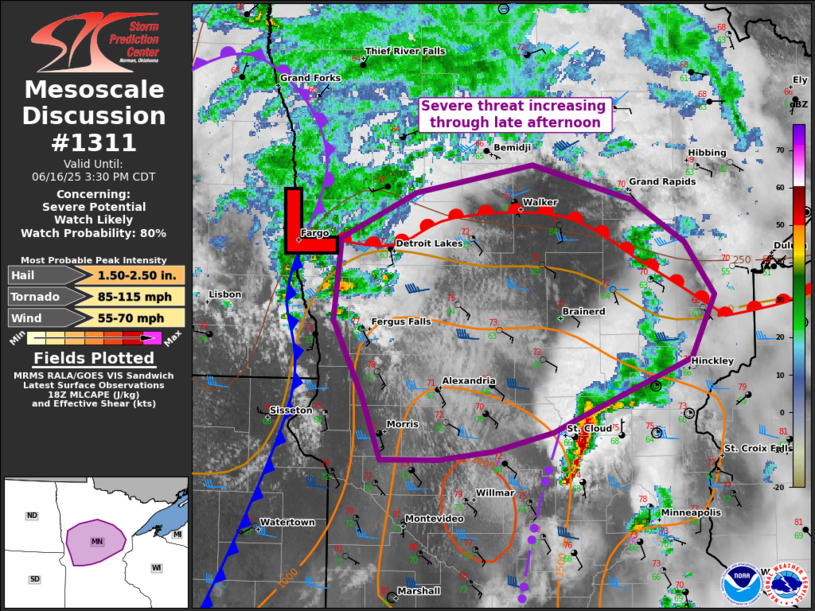
   Mesoscale Discussion 1311
   NWS Storm Prediction Center Norman OK
   0125 PM CDT Mon Jun 16 2025

   Areas affected...central MN

   Concerning...Severe potential...Watch likely

   Valid 161825Z - 162030Z

   Probability of Watch Issuance...80 percent

   SUMMARY...Thunderstorms should intensify ahead of an eastward-moving
   surface cyclone, starting in west-central Minnesota. A few
   supercells capable of large hail, damaging winds, and a couple
   tornadoes are possible. A watch will likely be needed with
   uncertainty on southern extent of the threat.

   DISCUSSION...Initial low-topped convection has increased near the
   southeast ND/west-central MN border area in vicinity of a surface
   cyclone. A corridor of greater insolation persists ahead of this low
   into the Brainerd Lakes area, northwest of regenerative elevated
   convection across east-central MN to northeast IA. This should yield
   further low-level destabilization and increasing moderate buoyancy
   into late afternoon. While 12Z CAMs largely underplayed the morning
   elevated convection, the RRFS has consistently signaled the
   surface-based convection may remain largely confined to near the
   surface low/warm front across central MN. Low-level shear is modest,
   but a belt of stronger 700-mb winds attendant to the shortwave
   impulse should support a few supercells in an emerging cluster that
   spreads east into early evening.

   ..Grams/Hart.. 06/16/2025

   ...Please see www.spc.noaa.gov for graphic product...

   ATTN...WFO...DLH...MPX...FGF...

   LAT...LON   46899636 47209562 47399446 47159349 46869297 46519268
               46079291 45669405 45579426 45459485 45389538 45389596
               45819613 46349643 46899636

   MOST PROBABLE PEAK TORNADO INTENSITY...85-115 MPH
   MOST PROBABLE PEAK WIND GUST...55-70 MPH
   MOST PROBABLE PEAK HAIL SIZE...1.50-2.50 IN
|
   Mesoscale Discussion 1314
   NWS Storm Prediction Center Norman OK
   0349 PM CDT Mon Jun 16 2025

   Areas affected...east-central to northern MN

   Concerning...Tornado Watch 423...

   Valid 162049Z - 162215Z

   The severe weather threat for Tornado Watch 423 continues.

   SUMMARY...The severe threat should increase into early evening as
   additional storms develop southward in central Minnesota and spread
   east.

   DISCUSSION...Initially low-topped convection has gradually deepened
   over the past hour. Cells near the surface cyclone in west-central
   MN have mainly had a brief tornado threat thus far. But an arcing
   line of towering CU towards Willmar ahead of the surface cold front
   suggests additional storms should form into the instability axis
   characterized by moderate buoyancy with MLCAPE of 1500-2500 J/kg.
   This activity should intensify into early evening and support a more
   sustained severe threat beyond brief tornadoes. The overall severe
   threat may peak into early evening with any sustained supercells
   that can interact with residual outflow from storms that have spread
   into west-central WI. MPX VWP data has sampled enhanced low-level
   SRH near this outflow.

   ..Grams.. 06/16/2025

   ...Please see www.spc.noaa.gov for graphic product...

   ATTN...WFO...DLH...MPX...FGF...

   LAT...LON   46569500 46879463 47279334 47329303 47219281 46939292
               46669272 46439272 46159290 45769304 45039312 44949354
               44979399 45179462 45589465 45969473 46249491 46569500

   MOST PROBABLE PEAK TORNADO INTENSITY...85-115 MPH
   MOST PROBABLE PEAK WIND GUST...55-70 MPH
   MOST PROBABLE PEAK HAIL SIZE...1.50-2.50 IN
|
 |
Media use of NWS Web News Stories is encouraged! Please acknowledge the NWS as the source of any news information accessed from this site. |
|

