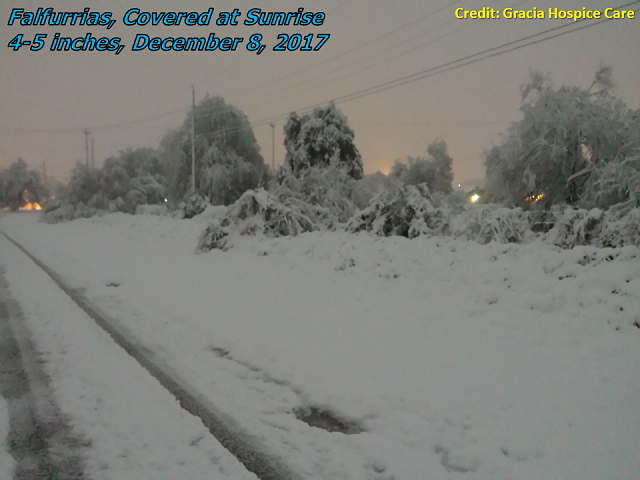
 Photos from across the Rio Grande Valley during and after the historic snow of December 8, 2017. Credits: NWS Brownsville/Rio Grande Valley, Rio Grande City Fire, Edinburg Fire, Harlingen CISD, US Border Patrol, Gracia Hospice Care of Falfurrias, Texas Commission on Environmental Quality, Texas Department of State Health Services. |
|
| Walking in a Winter Wonderland! Earliest Widespread Measurable Snow on Record Brings Out Christmas Spirit |
|
|
Report For the first time since the wondrous White Christmas of 2004, the entire Rio Grande Valley awoke to winter weather at or shortly after daybreak on December 8th. The winter weather was even more stunning, in light of what had been a record–warm 2017, a top–five (for most) warmest autumn (September–November), and late summerlike conditions hanging on for the first five days of December where even the beaches of South Padre Island were an appropriate place to relax, out or in the still warm (75°F) surf. On December 6th, "summer" was rudely erased by the first big cold front of the season. Afternoon temperatures between the 5th and 6th crashed more than 35°F, from the balmy mid 80s to the chilling upper 40s. Combined with gusty northwest winds, it felt colder still (upper 30s to lower 40s). As high pressure with roots in northwest Canada continued to push to the edge of the western Gulf tropics on the 7th, temperatures continued to fall, dipping to the mid to upper 30s across the Rio Grande Plains and low to mid 40s across the Valley during the day Thursday. Feels like temperatures fell into the upper 20s to mid 30s, as stiff north winds combined with occasional light rain or drizzle from somewhat warmer and more humid air overrunning the cold surface air to add more misery to the biting chill that followed so many warm and humid days to end November and start December. Overnight on the 7th, and continuing into the 8th, an embedded upper level disturbance descended the back side of a growing upper level trough that would soon stretch across the entire eastern two–thirds of the nation. The disturbance provided several critical pieces of the atmospheric puzzle (see Pattern Matters section) that would change miserable biting rain into a snowscape that brought impromptu celebrations of the season on a Friday, less than three weeks before Christmas. Light rain mixed with sleet and snow before changing to all snow, from northwest to southeast, on the 8th. The initial changeover occurred across the Rio Grande Plains of Jim Hogg and Zapata County between midnight and 2 AM, and would quickly scoot through the remaining ranch country before 4 AM, and reach much of the populated Valley before 6 AM. Because the low levels of the atmosphere were marginally conducive to snow, the highest accumulations were seen in stronger bands that fell before sunrise at the slighly higher elevation of the ranchlands (see radar loop, below), which allowed temperatures to fall to 32 or 33°F for the duration of the band. In locations where the bands tapered off, or where bands were less intense, snow accumulation was limited and often the snow would become mixed with rain again. Highest accumulation, ranging from 3 to nearly 6 inches, fell in a stripe from southwest Zapata County through northwest and northern Starr, southern Jim Hogg, and western Brooks County, extending northeast to areas west of Kingsville and ultimately to the Corpus Christi metro area, where 4 to 6 inches piled up before daybreak. Multiple bands developed or re–developed between 5 AM and noon, with additional snow for the aforementioned stripe from Zapata through Brooks but also sliding into the more populated Rio Grande Valley, mainly along and north of Interstate 2. Much of these bands fell after daybreak, which allowed low–latitude daylight to counter the moderate snow and hold accumulation down to around an inch. The final band exited southeast Cameron County (Brownsville to South Padre Island) soon after noon. The heavy, wet snow clung to trees, buildings, fences, windmills, etc. across the South Texas Brush Country, for a rare scene of beauty that could be a once or twice in a lifetime scene. In Falfurrias, snowfall rates reached 1 to 2 inches per hour and coated even paved roads with 1 to 2 inches (at least) of white, which closed a number of roads for a time during the morning of the 8th in and near Falfurrias. There were also some vehicle incidents in areas where slush or snow impacted roads, including around Falfurrias, along US 77 in northern Kenedy County, and along US 83 north of Zapata (where a school bus was hit by another vehicle that slid on an elevated bridge). For many others, however, the snow was a wonder to behold; children took time out to build small snowmen and taste the rare snow flakes from above during school breaks. Sunshine returned to the Mid and Upper Valley/Rio Grande Plains by mid afternoon, with temperatures rising into the lower 50s. Roads quickly dried up, though the snow pack from Zapata through Brooks County remained into early Saturday, and north–facing roofs, vehicles, etc. in the Lower Valley still had a dusting through noon on Saturday, December 9. While it may not technically have been a "Christmas" snow, for the Rio Grande Valley, it was the next best thing. 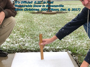 It’s Official! For the first time since December 25, 2004, measurable snow occurred at Brownsville/South Padre Island International Airport, measured at noon, December 8, 2017 |
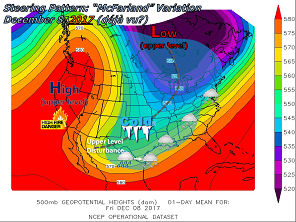 500 mb (~18,000 feet) steering pattern, and the general weather situation, for December 8, 2017 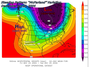 500 mb (~18,000 feet) steering pattern for December 24/25, 2004. Can you see the similarity? Pattern Matters 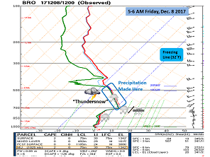 Atmospheric sounding (profile) from 6 AM, December 8, 2017, in Brownsville. As the atmosphere cooled from top to bottom, precipitation changed to snow. At the time of this images, sleet was falling in Brownsville – a result of the last warm layer at roughly 9,000 feet above ground. That warm layer would be erased soon after, and Brownsville saw several hours of light snow. In the snow production zone, instability was sufficient to produce "thunder snow", an event more familiar to east coast storms than the Rio Grande Valley. Thunder snow was also reported late at night near Corpus during heavier bands there. Almost forgotten amidst the snow was the bone chilling cold and Gulf Gale. The same upper level pattern (above) that supported snow helped develop a western Gulf Gale, again an event more common to the east coast Nor’easters than the southern tip of Texas. The Gale churned up 11 to 15 feet of rollicking seas (Beaufort Scale 7) with frequent winds of 34 knots or greater, and cranked up northwest winds east of US 77/Interstate 69E to over 20 mph overnight through early Friday morning. Wind chill temperatures plummeted into the 20s across Deep South Texas and the Valley, with lowest values on South Padre Island (20°). Later Friday and Friday night, the entire disturbance plowed eastward and led to the season’s first snow event from Louisiana through northern Mississippi, Alabama, and Georgia, the western Carolinas, and the mid Atlantic and New England states. Sunny skies and moderating temperatures melted all snow on the 9th, and 70 degree weather returned by December 10th. |
|
Quick Stats
Other notable snow events that affected many or parts of the Valley and Ranch areas*:
†Unknown how far west into the Rio Grande Valley or ranchlands these particular events stretched; data were not available for sites well inland.
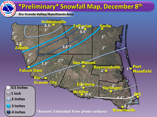 Preliminary snowfall map for December 8, 2017. Data from a mix of spotters, public safety officials, Collaborative Rain Hail and Snow Network (CoCoRaHS), trusted social media photographs, and the National Operational Hydrologic Remote Sensing Center. This map will be updated.  Radar loop of base reflectivity at 0.5° elevation, from around 11 PM CST on December 7 to 1 PM CST December 8th. 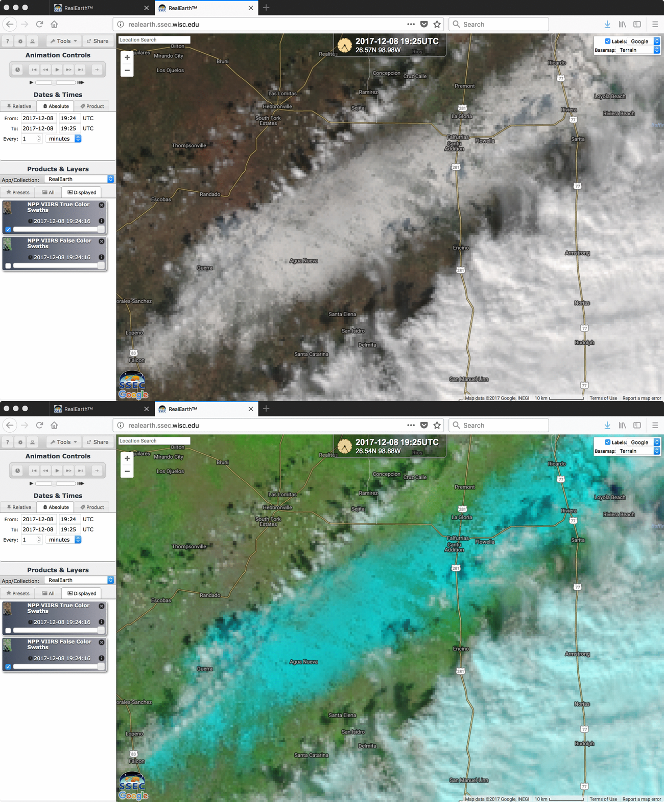 True and False color satellite photo of the stripe of heaviest snow from Zapata County through northern Starr, southern Jim Hogg, and western Brooks into the Corpus Christi area shortly after clouds cleared on December 8th. Data courtesy of the Cooperative Institute for Meteorological Satellite Studies at the University of Wisconsin-Madison. 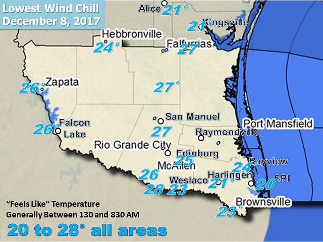 Minimum feels like (wind chill) temperatures early on December 8, 2017, across the Rio Grande Valley and South Texas Brush Country. |
|