|
In a year where rainfall and humidity had already left one of the greenest, lushest landscapes in recent memory for early April, a week of active weather provided more rainfall, as well as the first periodic lightning storms as the early spring chill that started the season (March) evolved into sultry, "soupy" days and nights for the first three weeks of April. Frequent upper level disturbances acted on the sultry air mass and triggered a combination of heavy rainfall and flooding (April 10, 12/13, and 14), frequent lightning strikes which led to some reported fires (April 10/11, 12/13, 14, 18), and minor wind damage and hailstorms - mainly across Zapata, Starr, and Jim Hogg Counties (April 12 and 18). The unsettled pattern had a connection from the eastern tropical Pacific Ocean – a probably sign of Ocean/Atmospheric Coupling due to a strengthening El Niño.
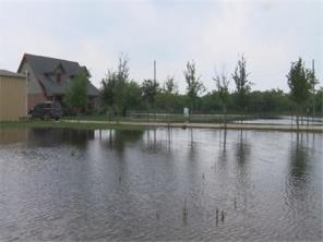
Photo of remnant high standing water along North Seminary Road in Edinburg on April 17th, 2015, one full week after torrential rains of up to 6 inches inundated the area and nearby locations from north Mission through Alton. Credit: KGBT-TV-4 Action News.
April 10th: Pooled Moisture Sets Stage for Flooding
A dissipating front edged south to the Rio Grande during the afternoon and evening. Hot, humid air with temperatures to around 90°F combined with the surface front and upper level energy to initiate rapidly developing storms (top left); moisture "pooling" along and just behind the front aided storm redevelopment over the same areas, centered on southwest to central Hidalgo County. After the rains tapered, measured and estimated totals indicated 4 to 6 inches from Peñitas/La Joya northeast through north Mission, Alton, and parts of Edinburg. Poor drainage areas, particularly around the colonias of Alton along and near State Road 107, were hardest hit; several homes had standing water, up to 2 feet in depth, inside them.
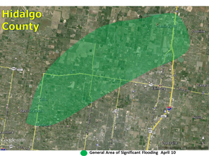
Estimated significant flood area in west central Hidalgo County during/after April 10th deluge. Some yards still had a foot or more of water a full week later (April 17).
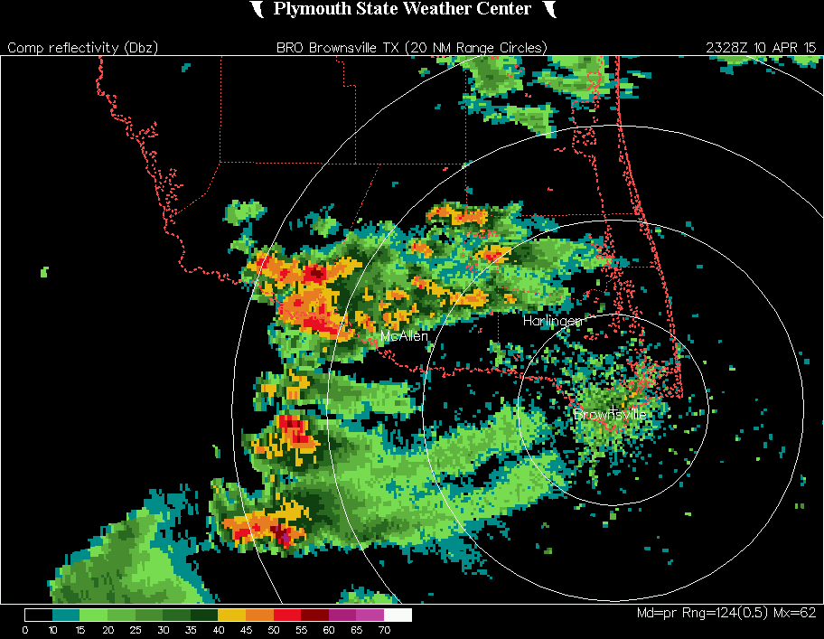
April 12th/13th: Season’s First Squall Rakes Rio Grande Plains
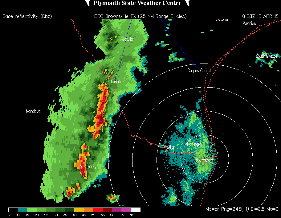
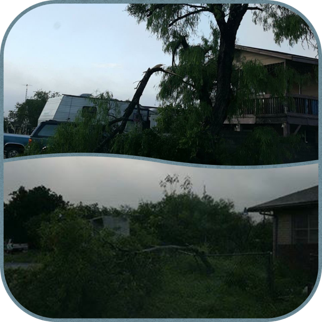
Very unstable air along the Sierra Madre Oriental during the late afternoon of Sunday, April 12th was activated by another, fairly potent upper level disturbance emanating from a persistent trough located along the Arizona/New Mexico border with Mexico. Several lines of storms, with bow–shaped segments, developed along/west of the Rio Grande from the Big Bend region south ward deep into Mexico’s Nuevo Leon and Coahuila State. One of these lines accelerated east and quickly reached Zapata County by mid evening on the 12th (above, right). At one point, Doppler radar in Brownsville indicated 90-100 mph winds with the storm, above 10,000 feet! The storm would rake the City of Zapata with estimated winds of 60 to 65 mph, knocking down dozens of limbs and power lines (above right). Fortunately, the core of the storm crossed a neighborhood of well built homes; as of this writing, no structural damage was reported.
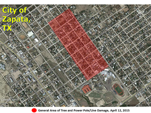
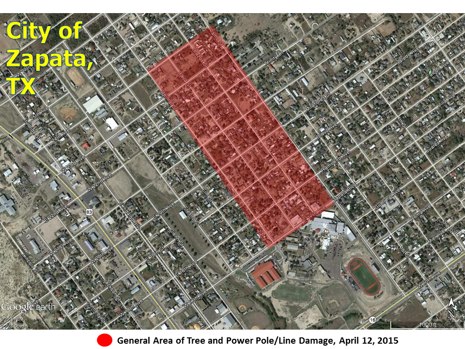
Estimated location of tree and power line damage in the City of Zapata, between 917 and 930 PM April 12th 2015.
|
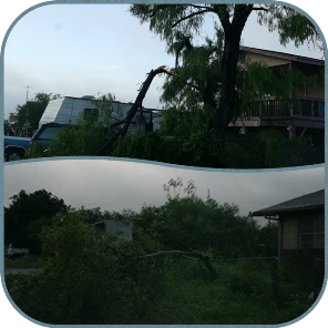
Photos of tree damage in the City of Zapata after estimated 60 to 65 mph wind raked neighborhoods between 17th and 24th Avenue. Credit: Alfonso "Poncho" Lopez of Zapata County
April 12th/13th: Season’s First Squall Rakes Rio Grande Plains Continued
The line continued marching into the ranchlands of Jim Hogg and Starr County, with unknown wind impacts but certainly plenty of lightning and downpours. Farther south, another segment moved along the river and reached the McAllen metropolitan region, with another inch of rainfall, frequent lightning, and gusty winds over 40 mph. That segment would continue through Cameron County and weaken off the coast with similar impacts in the Brownsville/Harlingen region; winds gusted to 47 mph at Valley International Airport just prior to midnight on the 12th. Boundaries left behind the initial line fired another slower moving band of thunderstorms from southeast Hidalgo through central Cameron County from 3 to 6 AM on the 13th, dropping another 1"+ inch; in total, parts of the Harlingen area received more than 2½ inches of rain from the event, with nuisance flooding of fields and some roads.
April 14: Ranch Storms Blow Front through Valley
The atmosphere quickly recovered by the afternoon of April 13th, with a lone severe thunderstorm dropping quarter (or larger) sized hail over Zapata by late afternoon. Another disturbance approached overnight, and by daybreak torrential rains had returned to the ranchlands from Zapata through Jim Hogg and Brooks County. A surface front was given momentum by the storms, and surged through the RGV before mid morning, stabilizing the atmosphere and killing off the threat for nothing more than showers. More than 3 inches fell in bands across northern Brooks County and the King Ranch in northern Kenedy County.
April 17: Near Miss – Stable Atmosphere Spares RGV Another Round
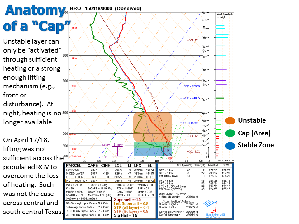
A deeper upper level disturbance that moved from Canada south into the southern Rockies and produced late season heavy snow that was partly to blame for vehicle/freight damage which closed Interstate 80 in Wyoming, linked up with the persistent subtropical jet farther south to generate widespread dangerous thunderstorms, including wind, hail, and even tornadoes, across much of Texas from April 17th into the 18th. The Rio Grande Valley was spared the action by a robust inversion, or "cap" of warm dry air overtop relatively cooler and moist air near the surface. The storms, which initiated just before sunset east of the Sierra Madre, produced some action across the Upper Valley/Ranchlands, where pea sized hail and 40 to 45 mph winds were observed near Lopeno (Zapata County). The loss of heating increased the cap strength as the storm(s) moved toward the mid Valley prior to midnight.
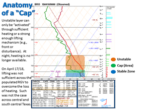
Atmospheric sounding (profile) from Brownsville at 7 PM April 17th, 2015. The strength of the cap, combined with lack of heating and the best lifting mechanisms north of the region, quickly eliminated the threat for dangerous thunderstorms prior to midnight.
|


