|
May 29th: Morning Surprise!
In a spring where the little engine (rainfall) really could, a line of thunderstorms, which was born in west Texas east of Lubbock and Midland and initially swept through the Dallas/Fort Worth Metroplex during the evening of May 28th, would get momentum from the atmosphere in the form of a rightward nudge, and soon impact areas from Del Rio to San Antonio during the late evening with local flooding and strong winds. Typically, linear thunderstorm systems that arrive in south central Texas toward midnight struggle to survive much beyond the Coastal Bend and Laredo area. Not this time. Strong storms eased into the northern ranchlands during the pre–dawn hours with a combination of gusty winds (44 mph at Laredo at 317 AM; 411 mph at Hebbronville, 37 mph at Brooks County/Falfurrias, 32 mph at Zapata, all between 415 and 430 AM),brief downpours, and plenty of lightning. The storms faded into a broken line as they headed for the coast, dropping moderate rainfall, 0.5 to 1.5 inches, across much of the mid and upper Valley for the Friday morning commute and also spiking briefly in McAllen and Edinburg, where wind gusts reached 54 mph at Miller Airport at 739 AM.
As the line neared the coast, the combination of the slowing momentum with convergence from light southeast flow cranked up the convection across eastern Cameron County between 930 and 1130 AM; the heaviest rainfall of the event brought 2.49 inches of soaking rain to east Brownsville (NWS office) and nearly 2 inches to Bayview. Minor flooding of poor drainage areas in Brownsville ensued. Equally, if not more, impressive than the rainfall was the rapid development of what is known as a "wake low" – an area of low pressure that sometimes follows the surge of high pressure than comes with sinking, cooler air in downdrafts and rain in the core of a strong thunderstorm. The low swung winds around to the east or southeast for about an hour near Brownsville, with peak winds cranking to 46 mph. The winds quickly shifted to the northwest behind an impressive roll cloud; the same winds continued for nearly two hours at South Padre Island, with frequent gusts over gale force (39 mph) which roughened surf and pushed water up to the dunes (below). Surface pressure fell five millibars, or 0.16 inches of mercury, with the passage of the low.
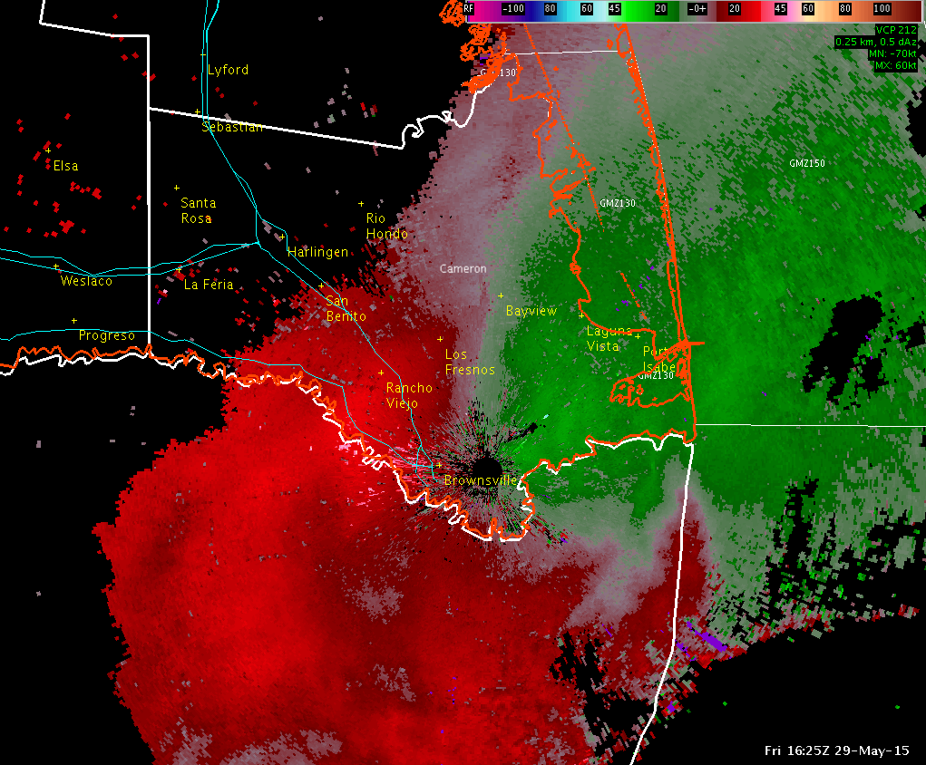
0.5° Base Velocity loop from 1125 AM to 125 PM May 29th 2015. Note the passage of the strong outbound velocity (red) which became strong inbound (green), all from the southeast, as the wake low (trough) passed by Brownsville.
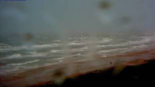
Rough surf running to the dune line on South Padre Island during the peak of the strong winds ahead of passage of a "wake low" behind strong thunderstorms in southeast Cameron County. Photo credit: https://spadre.com |
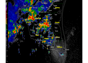
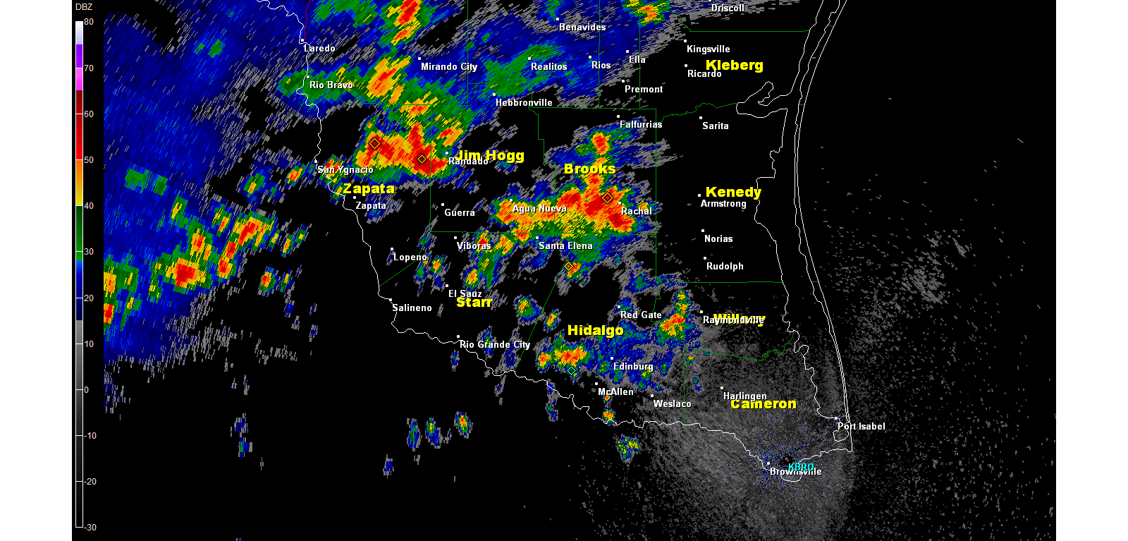
0.5° Base Reflectivity loop from around 6 PM through 8 PM CDT, May 30th 2015, showing development of heavy rain producing thunderstorm clusters from Hidalgo and Brooks County west through Starr, Zapata, and Jim Hogg County
May 30th: Afternoon Soaker
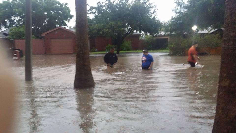
The combination of an approaching late season front from the north, warm humid air across the Deep South Texas, light winds that allowed an afternoon sea breeze to develop, and boundaries from storms moving south from Del Rio and Laredo set the stage for multi&nash;cell thunderstorm clusters to fire, mainly from northwest Cameron and eastern Hidalgo westward to the Rio Grande Plains during the mid to late afternoon, which carried into the early evening before sliding into Tamaulipas (Mexico) and dissipating. Stronger cells produced an estimated 3 to 4 inches just north of the Rio Grande in the San Juan/Alamo area, and another measured 4 inches in Rio Grande City (Starr County), pushing their monthly total over a foot (12.73 inches through the 30th)! The torrential rain pockets left a combination of urban and more life/property–threatening flash flooding, in both the San Juan/Alamo area (above left) where the rain overwhelmed septic systems and flooded streets with known poor drainage with at least 3 of water, and near Rio Grande City, where U.S. Highway 83 was flooded near Garceño and at least one home was evacuated from floodwaters near Escobares around 7 PM. Other heavy rains, estimated up to 4 to 5 inches, fell over open ranchlands of eastern Zapata and central Brooks County.
May 31st: Brownsville Blast
The remains of the aforementioned front washed out along the Rio Grande on the 31st, and just enough moisture was left behind to work along the sea breeze and assorted other old boundaries to kick off scattered afternoon showers and thunderstorms across Deep South Texas. Atmospheric dry air was able to sneak into the region and reduced the coverage of activity. Before the dry air arrived, a band of heavy rain with rolling thunder snuck across the Rio Grande in southeast Cameron County around daybreak, dropping nearly an inch from Brownsville to Bayview. During the late afternoon, a slow moving band of developing storms dropped a small area of very heavy rainfall around Harlingen; soon after, another cell would form from the Rio Grande near the Sabal Palm Sanctuary, then develop northwest to east Brownsville and park for nearly two hours, dumping more than 2.5 inches of rain! Prior to May 29th, Brownsville’s 3.73 inches ranked 32nd wettest (since 1878), and the official station needed a whopping 5.4 inches to break the prior May record of 9.12 inches set in 1982. Unbelievably, the local storms on the 29th (once) and 31st (twice) added 5.99 inches to shatter the prior record. A sports fan might look at this situation similar to a football game: Team down by three touchdowns (21 points) with five minutes to go in the game, and rallies to win on a last second field goal!
Thus, May bookended a record month, and record spring, for much of the Rio Grande Valley/Deep South Texas Ranchland region, a record that was also shattered in Texas to much more dire results from rapid water flash flooding, which killed over two dozen during the latter half of the month. And, like a light switch, June would "flip the script" and begin dry, which allowed the Rio Grande Valley to finally begin drying out.
|


