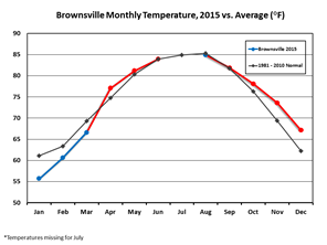
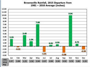
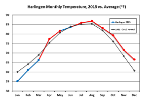
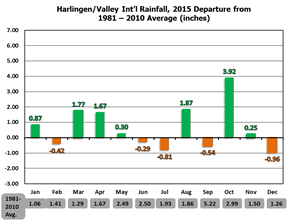
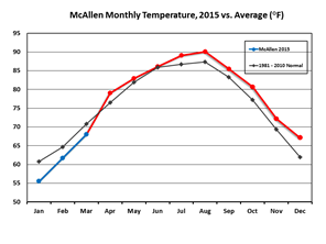
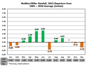
| Temperature and Precipitation Trends Brownsville, Harlingen, McAllen, in 2015 Cool weather with periodic precipitation opened 2015, but was quickly followed by an influx of warmer, humid air and repeated upper level disturbances from the southwest U.S. that energized the atmosphere and produced record to near record spring rains into May, with another round in late June ending the March to June period with a flourish and more than 40 inches for some locations across the King Ranch. Warm and relatively dry weather returned for most of summer, though punctuated by locally heavy rainfall in late August. A relatively dry September was followed by a very wet October, before the year closed out warm (temperature wise) and slightly below average (rainfall wise). Calendar year 2015 was the first in eight years with no Severe–level drought in Deep South Texas. The charts below show monthly temperature averages (left, line charts) and precipitation departures from the 1981–2010 average (right, bar charts) through the year. Averages and departures are based on the data sample of record, which dates back to 1878 for Brownsville, 1953 for Harlingen (Valley Airport), and 1961 for McAllen (Miller Airport). January through March were below the long term average for temperature, before the warmer patterns took over in mid to late spring. Summer (June to August) was slightly above average; the combination of El Niño with a positive phase Pacific Decadal Oscillation, with an assist from a positive phase North Atlantic and Arctic Oscillation, were the puzzle pieces that opened up an "endless summer" type scenario from September through December, with the first significant cooling not arriving until New Year’s Eve. Notable were the departures from average precipitation. In Brownsville, a three day surge to close May brought a new official record; lesser departures, but still notable (2 to 3 times average) values were seen elsewhere in May. September, easily the wettest month of the calendar year, actually fell a shade below average for most of the Rio Grande Valley as well as Texas as a whole. October made up the difference in a huge way, especially for the Lower and mid Valley; rainfall from Weslaco to Willacy and everywhere in between was two to as much as five times average (average for October ranges from 3 to 4 inches)! The helpful rainfall across the Rio Grande Valley in 2016 was not necessarily a boon for Falcon International Reservoir, but a continuation of improved rainfall across the Rio Grande Basin in Texas and northern Mexico also improved reservoir levels, which stood at 53.1 percent of conservation (Texas share) at year’s end; upstream Amistad was a hair above 66 percent of conservation(Texas share). For both locations, the levels were the highest seen since 2011, when the reservoirs were still releasing water from the incredible flows from 2010’s Hurricane Alex and its remains. |
|
 |
 |
 |
 |
 |
 |