
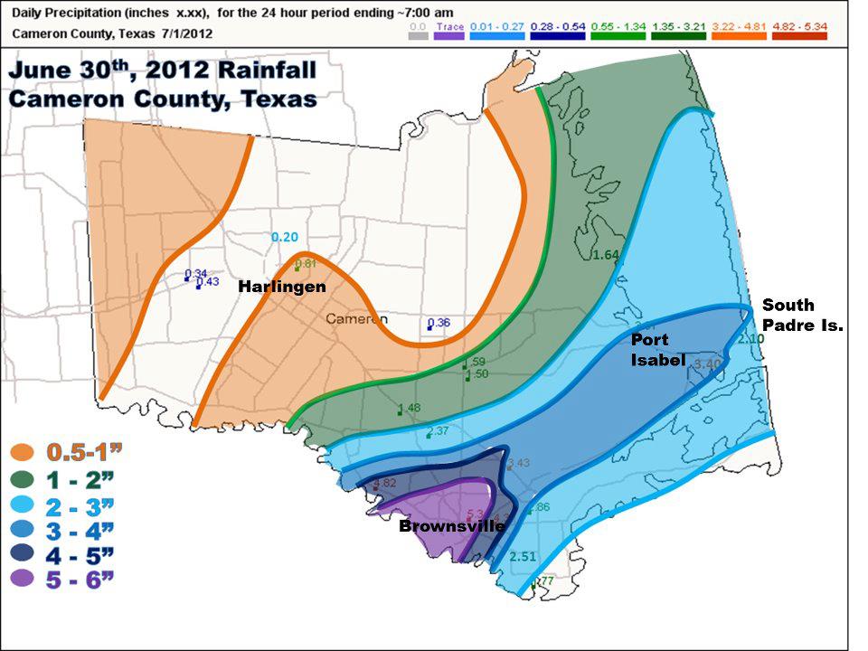
Rainfall map for Cameron County, June 30th 2012. Data include Community Collaborative Rain, Hail, and Snow (CoCoRaHS) network, cooperative sites, local airports, and wildlife refuges. |
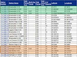
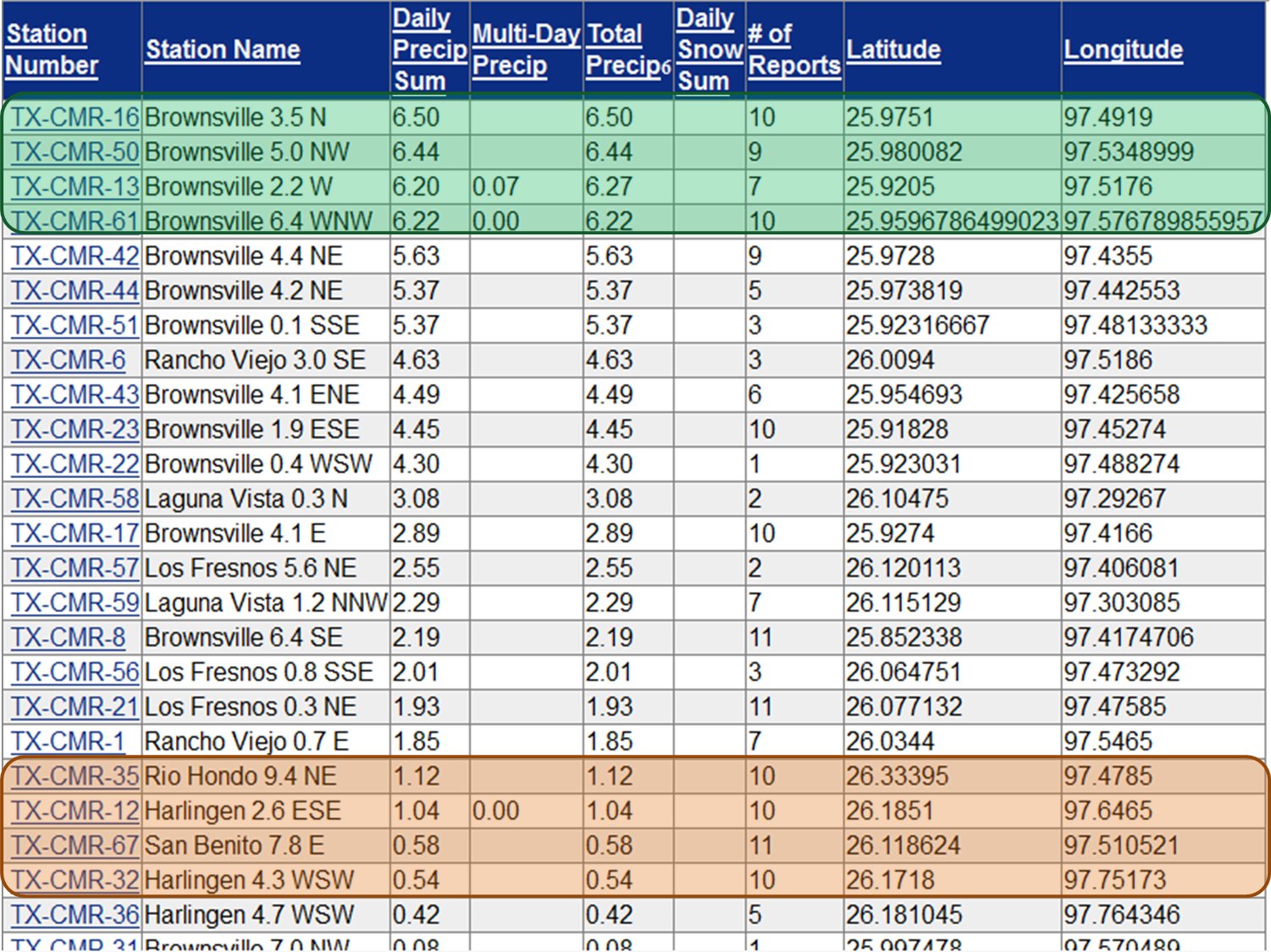
Tabular listing of CoCoRaHS rainfall data, Cameron County, June 29th through July 8th, inclusive. |
|
Summary
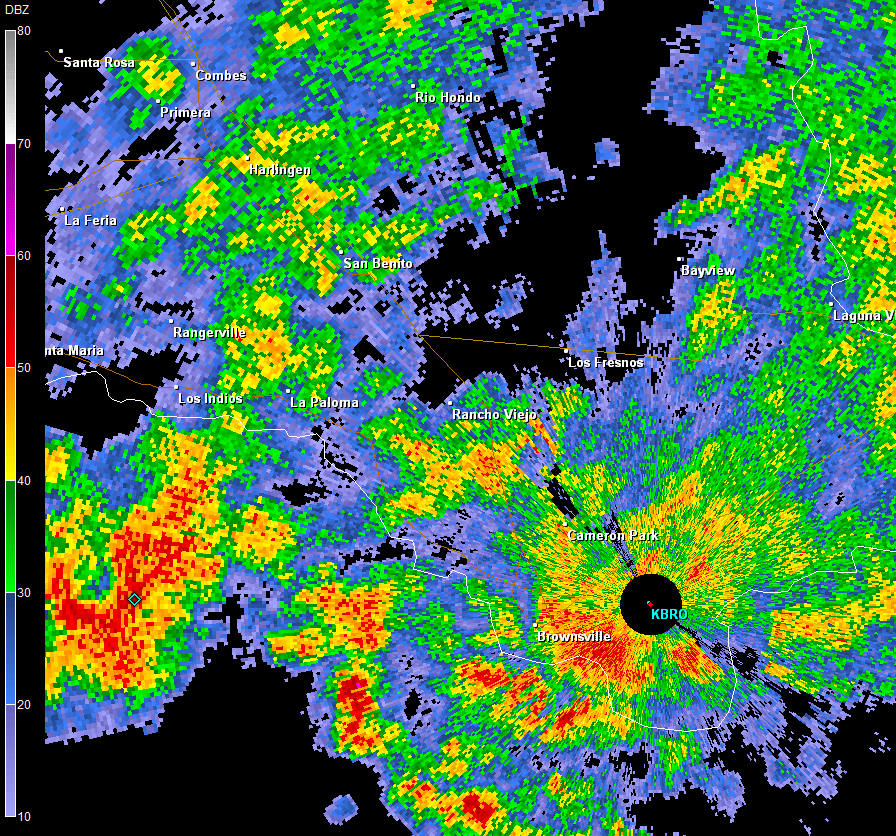
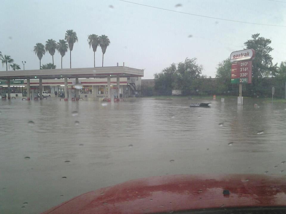
A weak upper level disturbance, which had produced a few days of healthy thunderstorms in the western Gulf of America during the final week of June, crossed the coast on June 30th and produced local downpours that flooded small portions of Cameron and Zapata/western Starr County. The disturbance combined with sea breeze influences and boundaries from activity across the Coastal Bend to enhance initial thunderstorms along the coast of eastern Willacy and Cameron County around noon. Boundaries from these storms combined with the circulation of the upper disturbance to create a system of thunderstorms which persisted in a very small area along and west of Highway 77 from Matamoros, Tamaulipas, Mexico to the north side of Brownsville, from 1 PM until a little after 5 PM. A final round of torrential rains swept through Brownsville just prior to 11 PM and dropped another inch in some areas of the city. Farther west, boundaries from stronger cells across the Rio Grande Plains near Laredo and just west of the river set up a "train" of storms that hugged the Rio Grande for several hours into the early evening of the 30th. A number of locations along and near Federal Highway 83 reported water across the road from near Roma to Lopeño, along the Starr/Zapata border. For Brownsville to South Padre Island, June 30th, 2012 marked the third consecutive year with more than 3 inches of rainfall. In 2010, inner feeder bands from Hurricane Alex dumped more than six inches of rain; in 2011, outer feeder bands from Tropical Storm Arlene dropped a wide area of 2 inches, with pockets of more than 3 inches.
A Tale of Two Cities
Between June 29th and July 8th, portions of north and west Brownsville turned into a lush tropical paradise, as grass grew tall, flowers bloomed, and mosquitoes and other insects flourished. Four individual events (June 29th and 30th; July 5th and 6th) did the trick with at least six inches of rain, and perhaps more than 7 inches between rain gauges. Just 20 miles northwest, less than an inch of rain fell during the same period, with un–irrigated grasslands showing tinges of green and much less growth and thickness. Such is the nature of boundary and sea breeze–driven thunderstorms. One city’s "feast" is another’s "famine". For parts of Brownsville on June 30th, the feast was too much (below right); floods closed several roads, overtopped resacas, and reached into properties near and in downtown. Until widespread rainfall soaks the entire Valley, drought conditions will vary markedly across the region.
Beyond the Brownsville and Harlingen differences, a similar feast/famine situation extended from the upper Valley near the river just a couple dozen miles into the ranch and brush country, where little or no rainfall fell June 30th and beyond. Such is the nature of routine summer storms across the Valley.
|

