|
Overview
A vigorous cold front, with an air mass sourced in the Canadian Prairies (below), drove through the Rio Grande Valley with quite a punch at the end of Thanksgiving Weekend, bringing extremely dry air on blustery northwest winds. From Saturday evening November 26th through Sunday afternoon November 27th, winds blew at 20 to 30 mph with occasional gusts to 40 mph. These winds swept out nearly all traces of moisture, replaced by relative humidity which fell below 30 percent at night and into the single numbers in most areas Sunday and Monday afternoon. Lighter winds Sunday night and starry skies set the stage for steady temperature drops; readings fell to or below freezing in many areas.
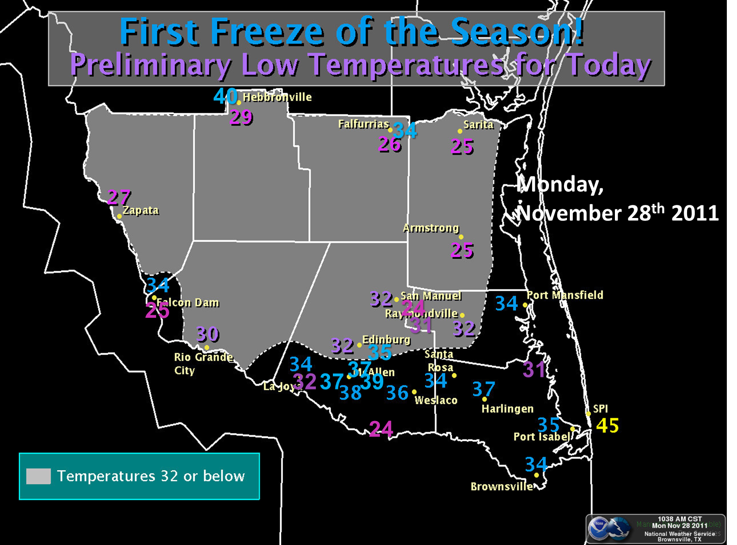
First Freeze of The Season: November 28th
Extremely dry air "airmailed" direct from the Canadian Prairies and surging across the drought–stricken southern Plains brought dew point temperatures down to near 0°F, a value seldom measured outside of true arctic air masses. Afternoon temperatures in the 60s on November 27th fell steadily during the evening and overnight, reaching the upper 20s and 30s across all of Deep South Texas and the Rio Grande Valley (above). More interesting than the temperature was the startling difference in values from one location to the next. This difference was a result of two factors: first, a continuation of very dry air through the night; dew points remained in the single digits and teens, keeping humidity between 20 and 40 percent! Second, winds between 5 and 7 feet above the surface (eye level) continued at 3 to 7 mph in most areas, reducing the potential for radiational cooling. Or did they? Temperature readings immediately above the surface and in wind protected areas fell much more sharply just before daybreak, with several locations dipping to the mid 20s for a few hours – a hard freeze.
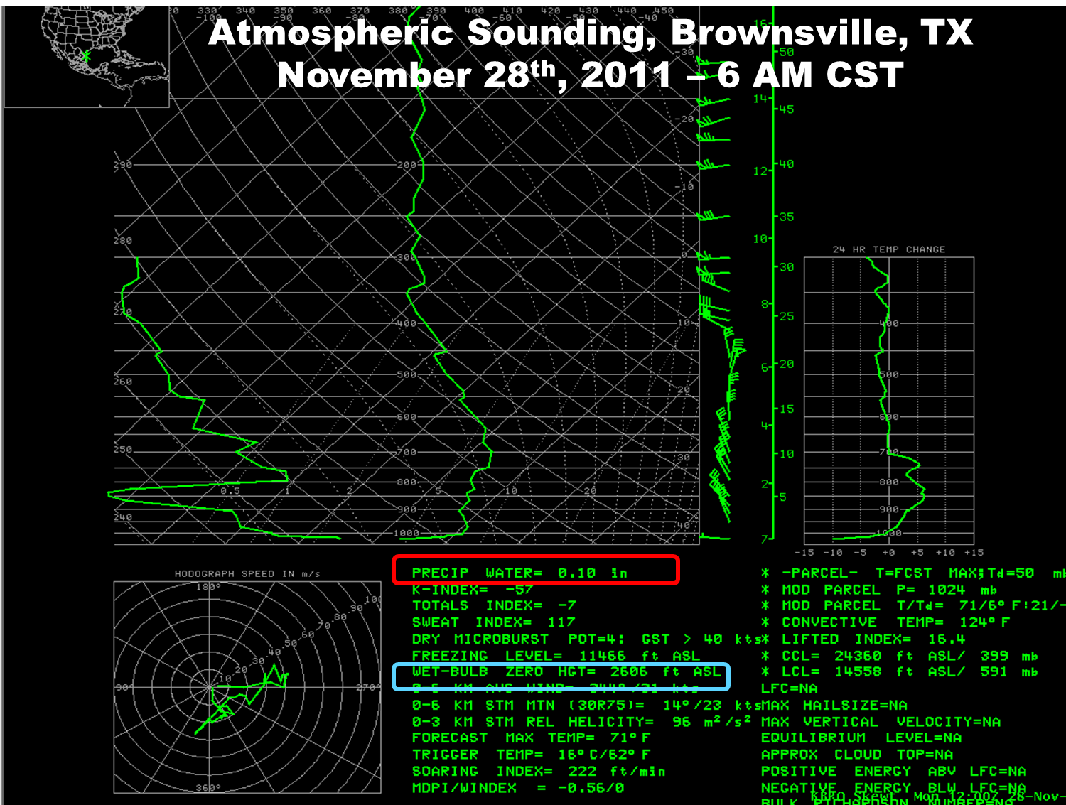
Agricultural and Residential Impacts: Just how widespread was the November 28th freeze? Probably more than we knew at the time; details will be provided in future assessments. While the ambient (air) temperature was above 32°F for much of the night, the wet bulb temperature, a critical parameter that measures the lowest temperature that can be achieved purely evaporative cooling of a water or ice "wetted*" surface, remained well below freezing. Calculated wet bulb temperatures generally ranged from 22°F to 31°F; most of the wet bulb temperatures were around 30°F when air temperature was between 34° and 36°F.
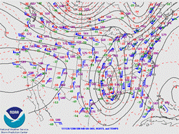
500 mb (generally, 15 to 18,000 feet) chart showing atmospheric flow pattern and wind speed/direction at 6 AM November 28th, 2011. Note the "express delivery" of Canadian air on pure northerly flow behind developing low latitude trough of low pressure over the southeastern U.S. |
Why the Wet Bulb is Important. Tender tropical vegetation, including citrus and sugar cane, contain moisture within the leaf, branch, and fruit structure. In very dry air, this moisture readily evaporates; this effectively cools the surrounding tissue to the wet bulb temperature. On November 28th, it was possible that exposed cold sensitive vegetation had effective temperatures below freezing due to evaporative cooling. Vegetation in wind protected areas likely saw a few hours of sub freezing ambient temperatures; additional evaporation may have brought effective temperatures well into the hard freeze range (below 28°F). These areas would include locations in the agriculture–rich Lower Rio Grande Valley.
For full details on how citrus and other cold sensitive crop growers use wet bulb temperatures to assess the need for damage mitigation, click here.
Windy
The surge of cold, dry air doesn’t arrive by magic; it takes energy. That energy manifest itself in heavy northerly winds, starting after dark Saturday evening across the ranchlands and spreading across the Lower Rio Grande Valley before midnight. A brief lull around sunrise early Sunday disappeared into a fairly constant roar of 20 to 30 mph winds, gusting near or above 40 mph at times, for most of the daylight hours Sunday. Peak gusts included 44 mph at Harlingen/Valley International, 46 mph at Bayview/Cameron County Airport, and 41 mph at McAllen/Miller Airport. While there were no specific reports of damage, the pulsing gusts made for difficult travel into and out of the Rio Grande Valley at the end of the holiday weekend.
Extremely Dry
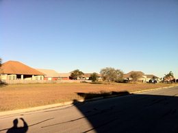
Occasionally, relative humidity plunges into the single digits across the Rio Grande Valley. Rarely has afternoon humidity plunged into the single digits on three consecutive afternoons. The incredibly dry air, which measured as low as 0.08 inches through the depth of the entire atmosphere during the late afternoon of Sunday the 27th, held in place through the 29th. Dew points only nudged from the single digits in most areas on the 27th and 28th into the teens on the 29th; air temperatures recovered well into the 80s by the 29th, leading to the third day of single digit afternoon humidity. The graphic at the bottom of the article shows the morning profile on the 28th; the photo below shows true Canadian sky blue at the same time.
Dedicated efforts by ranchers, residents, and visitors were crucial in having no significant wildfire starts through the period. Thanks to all who kept the Valley safe this Thanksgiving weekend!
 |

