 |
|
| Finally! Fast and Furious Rain Floods Poor Drainage Areas June 22/23, 2011 |
|
|
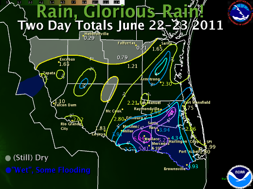
Overview Reasons On the 23rd, the surface low parked across Cameron County. Old boundaries, a pesky upper disturbance, and some heating into very unstable air triggered another round of tropical torrents from late morning through late afternoon. These rains spared the Brush Country and Rio Grande Plains, but inundated parts of the Lower Valley with 2 to 4 more inches of rain – some which fell in the same spots on the 22nd. By the 24th, the disturbance and surface low pressure area exited stage right, taking the precipitation with them. Impacts How Now, Drought? Thanks to our Facebook followers for providing photos and information through the first big rain event of the "wet" season of 2011. Thanks also to our CoCoRaHS observers, spotters, and others who provided valuable rainfall and other information through the event. |
|
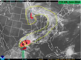 Satellite photo prior to the onset of torrential rains in Deep South Texas. The yellow dashed area shows energy boundary, stretching from the Great Lakes/Northeast U.S. southwest into central Texas. Red shaded area denotes active thunderstorm complex moving south into rich tropical moisture (green arrow). |
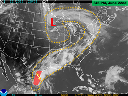 Satellite photo during peak of heavy rains in the Rio Grande Valley. Note the extent of activity well into Mexico; yellow dashed area shows entire energy boundary covering much of North America. |
|
The following are preliminary rain totals from June 22nd through 23rd for Deep South Texas and the Rio Grande Valley.
PUBLIC INFORMATION STATEMENT
NATIONAL WEATHER SERVICE BROWNSVILLE TX
1115 AM CDT FRI JUN 24 2011

AN UPPER LEVEL LOW PRESSURE SYSTEM AND ABUNDANT TROPICAL MOISTURE
PRODUCED WELCOME RAINS ACROSS PARCHED DEEP SOUTH TEXAS ON WEDNESDAY
AND AGAIN ON THURSDAY. LOCALLY HEAVY RAINFALL ACROSS CERTAIN AREAS,
REPLENISHED BADLY NEEDED SOIL MOISTURE. THE FOLLOWING ARE 2 DAY
RAINFALL AMOUNTS FOR SELECT LOCATIONS ENDING AROUND 8 AM THIS
MORNING.

AIRPORTS/ASOS/AWOS/RAWS
============================
BROWNSVILLE             4.93 INCHES
SANTA ANA               3.57
MCALLEN                 3.54
LAGUNA ATASCOSA         2.06
HARLINGEN               1.97
LINN-SAN MANUEL         1.39
EDINBURG                1.15
ZAPATA                  0.63
HEBBRONVILLE            0.06
FALFURRIAS              0.06


NWS COOPERATIVE OBSERVERS
============================
WESLACO                 6.04 INCHES
MERCEDES                5.41
HARLINGEN               4.34
SANTA ROSA              3.94
EDINBURG                2.80
RAYMONDVILLE            2.60
ARMSTRONG               2.30
RIO GRANDE CITY         2.02
SOUTH PADRE ISLAND      1.99
LA JOYA                 1.83
MCALLEN                 1.80
PORT ISABEL             1.80
PORT MANSFIELD          1.75
ESCOBAS                 1.65
SARITA                  1.65
FALCON RESERVOIR        1.02
HEBBRONVILLE            0.20

COCORAHS/HYDROLOGIC GAGES/MISC
===============================
RAYMONDVILLE  5.8 E      6.43 INCHES
HARLINGEN     4.7 WSW    5.27
HARLINGEN     4.3 WSW    4.72
BROWNSVILLE   4.1 E      4.44
MISSION       1.9 ENE    4.25
BROWNSVILLE   2.2 W      4.03
BROWNSVILLE   6.4 SE     3.87
BROWNSVILLE   1.9 ESE    3.84
BROWNSVILLE   0.1 SSE    3.68
HARLINGEN     2.6 ESE    3.40
ALAMO         1.5 NNE    3.40
RIO HONDO     4.4 NE     3.27
EDINBURG      1.1 ESE    3.18
BROWNSVILLE   4.4 NE     3.06
SAN BENITO    5.0 SSE    2.93
LOS FRESNOS   0.3 NE     2.32
BROWNSVILLE   0.7 E      1.97
RANCHO VIEJO  0.7 E      1.82
BAYVIEW       2.9 N      1.70
BROWNSVILLE   5.0 NW     1.69
LA JOYA       11.1 N     1.69
|
|
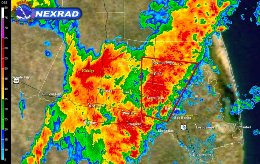 Base reflectivity, 05° elevation, at 230 PM CDT June 22nd. Red box was for severe thunderstorm warning, triggered by similar looking storms that produced a 66 mph wind gusts an hour earlier at Valley International Airport. |
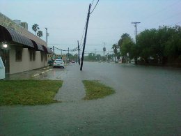 Urban flooding, 9th and Kimball in Raymondville. Courtesy of Willacy Skywarn via Facebook. |