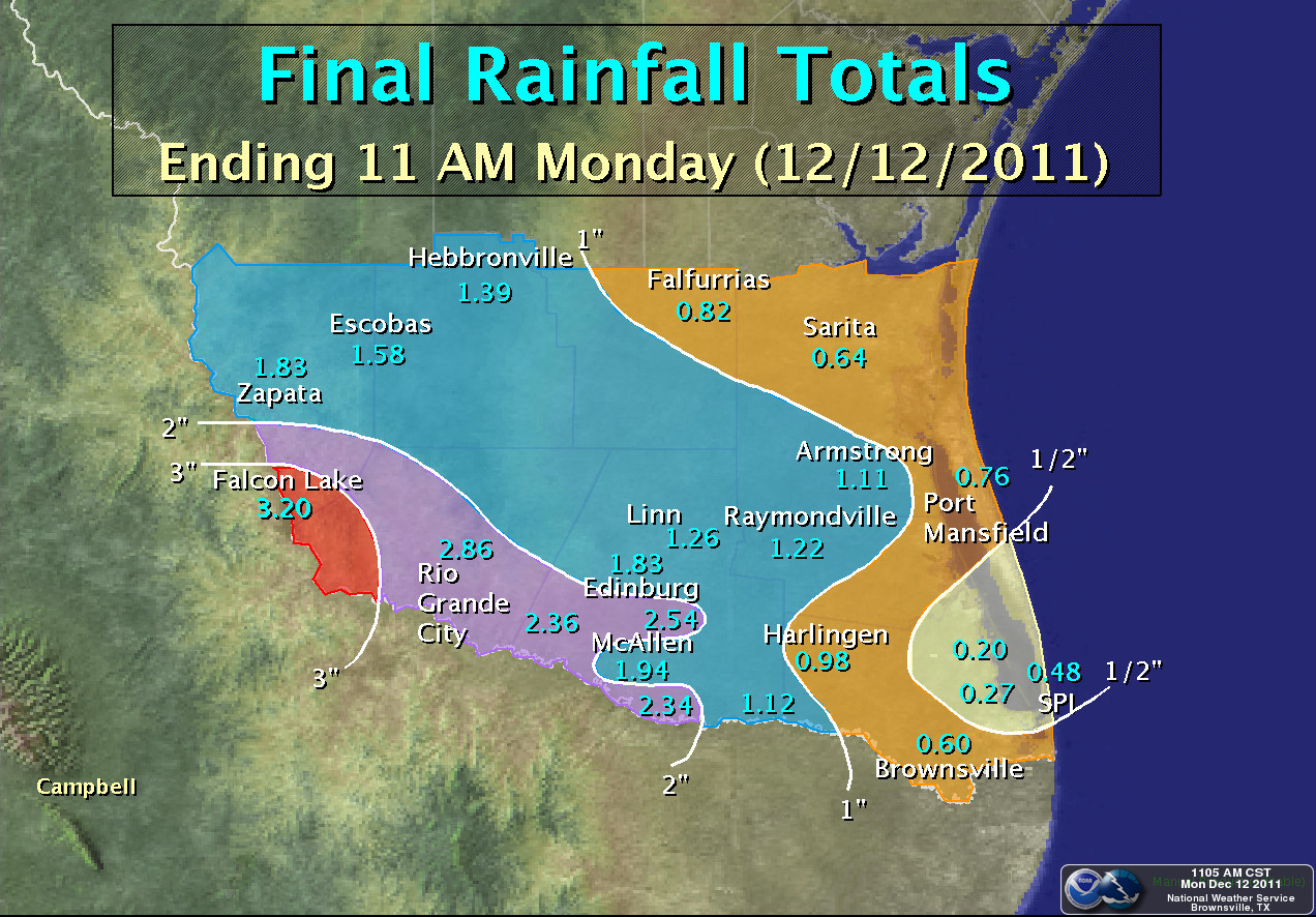
 Observed rainfall, from 12 AM (Midnight) December 10th through 11 AM December 12th, 2011. |
|
| Worth the Wait! Steady Rains Drench the Valley December 10–11 |
|
|
Summary Though more rains are needed to significantly alleviate the drought, the combination of a slow, soaking rain followed by two days of persistent clouds, cool temperatures, high humidity, and light winds allowed for much of the water to soak into the soil rather than evaporate quickly. Warm, humid conditions that followed help bring at least temporary green back to a number of locations, a nice change from the tan and dusty landscape since mid summer. The following summary lists observed rainfall from airport stations, cooperative observers, and weather enthusiasts. Thanks to everyone who provided detailed measurements to help fill in gaps that were not readily apparent on radar, which underestimated storm total rainfall significantly in areas where totals were greatest.
PUBLIC INFORMATION STATEMENT...UPDATED
NATIONAL WEATHER SERVICE BROWNSVILLE TX
842 AM CST SUN DEC 11 2011

...FIRST WIDESPREAD RAINS IN NEARLY A YEAR SOAK THE VALLEY...

A SERIES OF MID AND UPPER LEVEL DISTURBANCES COMBINED WITH A LOW
PRESSURE TROUGH ALONG THE LOWER TEXAS COAST TO LIFT MOISTURE INTO
SIGNIFICANT RAINS FROM THE RIO GRANDE VALLEY TO THE RANCHLANDS OF
ZAPATA...JIM HOGG...BROOKS...AND KENEDY COUNTY. EVENT TOTALS AS OF
8 AM DECEMBER 11TH RANGED FROM AROUND ONE HALF INCH NEAR THE CAMERON
COUNTY COAST TO MORE THAN 2 INCHES FROM HIDALGO TO ZAPATA COUNTY.

FOR LOCATIONS IN WESTERN HIDALGO AND EASTERN STARR COUNTY...THE
TWO DAY RAINFALL DECEMBER 10TH AND 11TH WAS NEARLY 50 PERCENT OF THE TOTAL
RAINFALL OBSERVED DURING THE PRIOR FOURTEEN MONTHS!

THE FOLLOWING IS A PRELIMINARY SUMMARY OF RAINFALL AS OF 8 AM CST
DECEMBER 11TH.  THIS LIST WILL BE UPDATED AS INFORMATION CHANGES FROM
ADDITIONAL RAINFALL AND/OR NEW OBSERVATIONS.

NOTE: UPDATED FOR LEGEND DESCRIPTIONS


CITY/TOWN                   COUNTY        RAIN     OBS TYPE

FALCON LAKE                 STARR         2.98      RAWS
RIO GRANDE CITY**           STARR         2.60      COOP
MCALLEN 2.4 NE              HIDALGO       2.40      COCORAHS
MISSION 1.9 ENE             HIDALGO       2.23      COCORAHS
SANTA ANA/LOWER RGV NWR     HIDALGO       2.22      RAWS
LA JOYA                     HIDALGO       2.00      COOP
PHARR 5.1 N                 HIDALGO       1.96      COCORAHS
LAREDO/INTL ARPT            WEBB          1.94      ASOS
MCALLEN 3 SW*               HIDALGO       1.93      CWOP
MISSION 1.5 E*              HIDALGO       1.92      CWOP
MCALLEN 3 N*                HIDALGO       1.90      CWOP
MCALLEN/MILLER INTL ARPT    HIDALGO       1.86      ASOS
ALAMO 1.5 NNE               HIDALGO       1.82      COCORAHS
MISSION 2 E*                HIDALGO       1.73      CWOP
ZAPATA/ZAPATA CO ARPT       ZAPATA        1.68      AWOS
EDINBURG                    HIDALGO       1.52      COOP
HEBBRONVILLE                JIM HOGG      1.39      COOP
RAYMONDVILLE                WILLACY       1.22      COOP
LINN/SAN MANUEL NWR         HIDALGO       1.20      RAWS
WESLACO 3.5 N*              HIDALGO       1.12      CWOP
ARMSTRONG                   KENEDY        1.07      COOP
WESLACO/MID VALLEY ARPT     HIDALGO       1.00      AWOS
LOS FRESNOS 0.3 NE          CAMERON       0.99      COCORAHS
HARLINGEN                   CAMERON       0.97      COOP
SAN MANUEL 5 E              HIDALGO       0.96      CRN
HEBBRONVILLE/JIM HOGG CO    JIM HOGG      0.96      AWOS
PORT MANSFIELD              WILLACY       0.76      COOP
EDINBURG/INTL ARPT***       HIDALGO       0.75      AWOS
HARLINGEN/VALLEY INTL ARPT  CAMERON       0.73      ASOS
HARLINGEN 2.6 ESE           CAMERON       0.70      COCORAHS
KINGSVILLE/NAS              KLEBERG       0.69      ASOS
FALFURRIAS                  BROOKS        0.68      COOP
BROWNSVILLE 2.2 W           CAMERON       0.67      COCORAHS
FALFURRIAS 0.5 WNW          BROOKS        0.65      COCORAHS
SARITA                      KENEDY        0.64      COOP
BROWNSVILLE 6.4 SSE         CAMERON       0.62      COCORAHS
BROWNSVILLE/SPI ARPT        CAMERON       0.57      ASOS
FALFURRIAS/BROOKS CO ARPT   BROOKS        0.50      AWOS
BROWNSVILLE 0.1 SSE         CAMERON       0.56      COCORAHS
SOUTH PADRE ISLAND          CAMERON       0.48      COOP
BAYVIEW/CAMERON CO ARPT     CAMERON       0.27      ASOS
LAGUNA ATASCOSA NWR         CAMERON       0.20      RAWS


OBS TYPE LEGEND:
ASOS - AUTOMATED SURFACE OBSERVING SYSTEM (NWS/DOD)
AWOS - AUTOMATED WEATHER OBSERVING SYSTEM (FAA/OTHERS)
COOP - COOPERATIVE OBSERVER (NWS)
CWOP - CITIZENS WEATHER OBSERVING PROGRAM
RAWS - REMOTE AUTOMATED WEATHER SYSTEM
CRN - CLIMATE REFERENCE NETWORK
COCORAHS - COMMUNITY COLLABORATIVE RAIN HAIL AND SNOW NETWORK

*ESTIMATED BASED ON 24 HOUR LISTED TOTALS
**NO INFORMATION FOR EARLY MORNING DECEMBER 10TH.
***MEASUREMENT MAY NOT BE REPRESENTATIVE OF NEARBY LOCATIONS
|
|

