 (T)raining and Flooding in Cameron County 4 to 7 inches Blitz Brownsville, Los Fresnos September 19th 2010 |
|
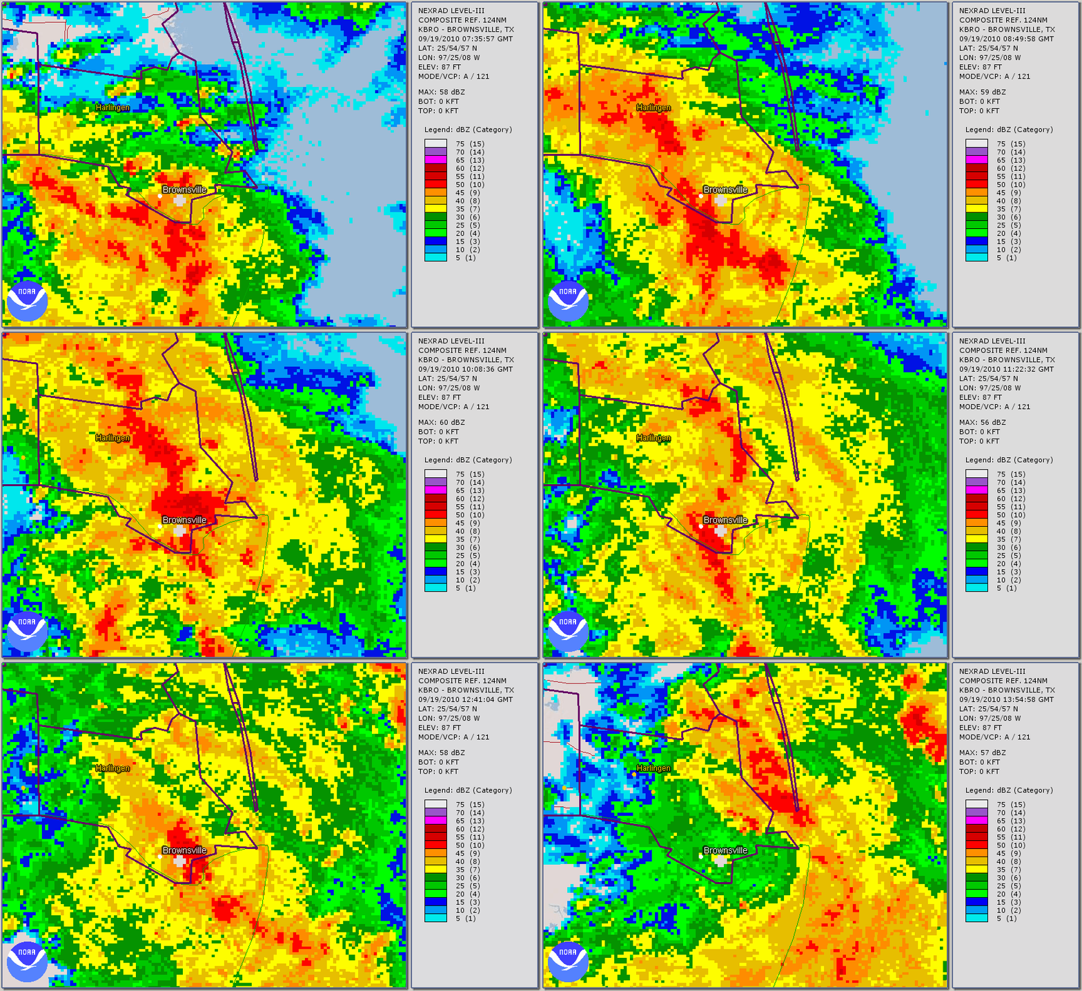
Overview The deep moisture struck jackpot for torrential rains and dangerous flooding early on September 19th, when upper level atmospheric energy combined with lower level converging air (and possible nocturnal low level jet of extremely moisture laden air from the Gulf). This synergy produced a prolonged band of torrential rains in the area of the peak convergence, just inland from the Gulf and covering south central Cameron County roughly between 3 AM and 8 AM, before the area pushed off to the east and northeast between 8 and 9 AM CDT (below). Between 5 and 7 inches of rain fell from Brownsville to near San Benito, creating extensive flooding in the area including impacting perhaps 100 or more structures, particularly in poorly draining areas. Much of the flooding in Brownsville was the result of a domino effect from most resacas being filled, causing a general backup in the normal drainage flow from the resacas to the city water treatment plant and beyond. The slowed drainage left some areas with high water several days after the main event. Impacts
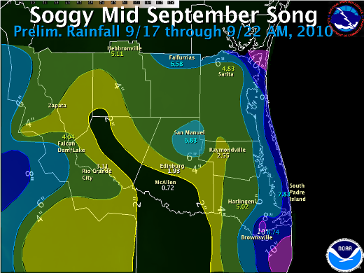
Thanks to City of Brownsville Emergency Management, Cameron County Emergency Management, and The Brownsville Herald for many of the reports listed here. In addition to the heavy rains, persistent fetch of moderate east winds maintained dangerous rip currents across the beaches of South Padre Island through the weekend of September 18th and 19th and into the 20th, along with high surf. Tides ran 1 to 1.3 feet above predicted, including exceeding 2.5 feet at Port Isabel on the 19th (2.59 feet at 330 AM CDT). Tidal run–up reached just below the dune lines, but likely shut down the county beach access points to vehicular traffic during the period. As of this writing, there were no injuries or fatalities due to the active surf and high tides. Rainfall Text Table PUBLIC INFORMATION STATEMENT NATIONAL WEATHER SERVICE BROWNSVILLE TX 1242 PM CDT THU SEP 23 2010 ...PRELIMINARY FINAL RAINFALL SEPTEMBER 17TH THROUGH 22ND... UPDATED...INCLUDES DATA RECORDED DURING THE MORNING OF SEPTEMBER 23RD. THE FOLLOWING ARE PRELIMINARY RAINFALL TOTALS DURING THE PERIOD OF SEPTEMBER 17TH THROUGH 22ND...WHEN DEEP TROPICAL MOISTURE ASSOCIATED WITH A SERIES OF UPPER LEVEL DISTURBANCES MOVED ACROSS DEEP SOUTH TEXAS AND PRODUCED SEVERAL INCHES OF RAINFALL. IN THE TABLE BELOW...INFORMATION THAT FOLLOWS THE LOCATION NAME...FOR EXAMPLE BROWNSVILLE 4.2 NE...INDICATES DISTANCE IN MILES AND COMPASS DIRECTION FROM THE CENTER POINT OF THE CITY OR TOWN. NOTES: BROWNSVILLE/SOUTH PADRE INTERNATIONAL AIRPORT SHATTERED ITS PREVIOUS RECORD FOR SEPTEMBER 19TH. UNOFFICIALLY...6.48 INCHES FELL WHICH WAS 1.24 INCHES ABOVE THE PRIOR RECORD OF 5.24 INCHES FOR THE DATE. FOR SEPTEMBER 2010 THUS FAR...BROWNSVILLE/SOUTH PADRE INTERNATIONAL AIRPORT HAS EXCEEDED 10 INCHES AND IS NOW UNOFFICIALLY AT 12.32 INCHES...WHICH RANKS UNOFFICIALLY AS THE 10TH WETTEST SEPTEMBER ALL TIME...SINCE RECORDS BEGAN IN THE LATE 19TH CENTURY. IT LOOKS NEARLY CERTAIN THAT BROWNSVILLE WILL RISE FARTHER UP THE CHART WITH MORE RAIN TO COME BEFORE MONTH`S END. REACHING NUMBER ONE IS VERY UNLIKELY. IN 1886...A WHOPPING 30.57 INCHES FELL IN SEPTEMBER...MAKING IT THE ALL TIME WETTEST MONTH IN RECORDED HISTORY AT BROWNSVILLE. LOCATION COUNTY RAINFALL OBS TYPE REMARKS BROWNSVILLE 4.2 NE CAMERON 10.26 COCORAHS THRU 900 AM 9/22* BROWNSVILLE 4.4 NE CAMERON 9.91 COCORAHS THRU 900 AM 9/22 BROWNSVILLE 4.1 E CAMERON 9.40 COCORAHS THRU 900 AM 9/23 BROWNSVILLE 4.9 NW CAMERON 9.39 COCORAHS THRU 900 AM 9/23 BROWNSVILLE 0.1 SSE CAMERON 9.17 COCORAHS THRU 900 AM 9/23 BROWNSVILLE/SPI ARPT CAMERON 8.81 ASOS THRU 900 AM 9/23 BROWNSVILLE 3.5 N CAMERON 8.56 COCORAHS THRU 900 AM 9/23 LOS FRESNOS 0.3 E CAMERON 8.50 COCORAHS THRU 900 AM 9/23 BROWNSVILLE 5.0 NNW CAMERON 8.35 COCORAHS THRU 900 AM 9/23 BROWNSVILLE 2.2 W CAMERON 8.29 COCORAHS THRU 900 AM 9/23 SOUTH PADRE ISLAND CAMERON 7.83 MESONET THRU 900 AM 9/23 RANCHO VIEJO 0.7 E CAMERON 7.61 COCORAHS THRU 900 AM 9/23 BROWNSVILLE 0.9 SW CAMERON 7.17 COCORAHS THRU 900 AM 9/21 HARLINGEN 2.6 ESE CAMERON 6.99 COCORAHS THRU 900 AM 9/23 BROWNSVILLE 0.8 NNW CAMERON 6.88 COCORAHS THRU 900 AM 9/22* RANCHO VIEJO 3.0 SE CAMERON 6.84 COCORAHS THRU 900 AM 9/20 LINN/SAN MANUEL NWR HIDALGO 6.88 MESOWEST THRU 900 AM 9/23 FALFURRIAS BROOKS 7.68 COOP THRU 700 AM 9/23 LAGUNA ATASCOSA NWR CAMERON 6.35 MESOWEST THRU 900 AM 9/23 BAYVIEW/ARPT CAMERON 6.30 ASOS THRU 900 AM 9/23 SAN MANUEL HIDALGO 5.96 COOP THRU 900 AM 9/23 SAN BENITO 5.0 SSE CAMERON 5.74 COCORAHS THRU 900 AM 9/23 HEBBRONVILLE JIM HOGG 5.32 COOP THRU 815 AM 9/23 ARMSTRONG KENEDY 5.26 COOP THRU 645 AM 9/23 SARITA 7 E KENEDY 5.25 COOP THRU 800 AM 9/23 HARLINGEN CAMERON 5.04 COOP THRU 800 AM 9/23 RIO HONDO 9.4 NE CAMERON 4.88 COCORAHS THRU 900 AM 9/21 PALM VALLEY 2.2 SSW CAMERON 4.50 COCORAHS THRU 900 AM 9/23* HARLINGEN 3.3 WSW CAMERON 4.14 MESONET THRU 900 AM 9/22 HARLINGEN 4.7 WSW CAMERON 4.13 COCORAHS THRU 900 AM 9/20 HARLINGEN 4.3 WSW CAMERON 4.11 COCORAHS THRU 900 AM 9/23* FALCON LAKE STARR 4.04 MESOWEST THRU 900 AM 9/23 MERCEDES HIDALGO 3.80 COOP THRU 700 AM 9/23 HARLINGEN/VIA CAMERON 3.70 ASOS THRU 900 AM 9/23 LA JOYA 11.1 N HIDALGO 3.60 COCORAHS THRU 900 AM 9/23 RIO GRANDE CITY STARR 3.11 COOP THRU 715 AM 9/23 EDINBURG 1.1 WSW HIDALGO 2.64 COCORAHS THRU 900 AM 9/22 RAYMONDVILLE WILLACY 2.57 COOP THRU 730 AM 9/23 LA JOYA HIDALGO 2.56 COOP THRU 615 AM 9/23 FALCON DAM STARR 2.05 COOP THRU 830 AM 9/23 ALAMO 1.5 NNE HIDALGO 1.88 COCORAHS THRU 900 AM 9/23 SANTA ANA NWR HIDALGO 0.90 MESOWEST THRU 900 AM 9/23 MCALLEN/MILLER HIDALGO 0.72 ASOS THRU 900 AM 9/23 MCALLEN 1.7 SSE HIDALGO 0.60 COCORAHS THRU 900 AM 9/22 MCALLEN HIDALGO 0.33 COOP THRU 700 AM 9/23 *DATA INCOMPLETE. |
 Loop of composite reflectivity, 230 AM until 9 AM CDT, September 19th. Note repeating, or "training" red and maroon echoes along and just east of the Federal Highway 77 corridor between Brownsville and San Benito for most of the period. |