|
Overview
The Rio Grande Valley dodged a tropical bullet during the afternoon and evening of June 30th, 2010, as Hurricane Alex twisted, turned, and tightened into a formidable cyclone as it slammed into the north central coast of Tamaulipas, Mexico, likely causing significant damage to fishing village which had been fortunately been evacuated. With the inner core, or eyewall, making landfall around 100 miles south of the Rio Grande, the Valley was subject to persistent outer feeder bands which brought moderate to strong tropical storm force (39 to 66 mph) winds, heavy rains causing scattered flooding, and embedded tornadoes and probably some waterspouts.
Track History
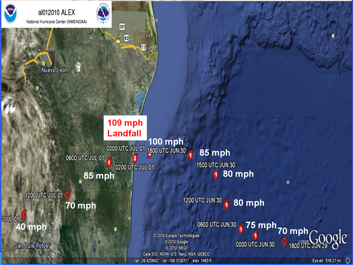
Alex began as an early season tropical wave over the very low latitudes of the central Atlantic Ocean during mid June, which ebbed and flowed but never dissipated while moving through warmer than average waters in the deep tropics. By June 24th, Alex was showing signs of organizing in the western Caribbean, but was still fighting wind shear. Finally, the cyclone became a Tropical Depression on the 25th, and named Tropical Storm Alex on the 26th. Alex began organizing steadily during the afternoon of the 26th, before crashing into Belize as a Tropical Storm. Alex crossed Belize and the Yucatan Peninsula overnight on the 26th and through most of Sunday, June 27th, before emerging as a battered – but still well organized – tropical depression. On June 28th, Alex began moving slowly away from the Yucatan and into the southwest Gulf, and struggled to intensify.
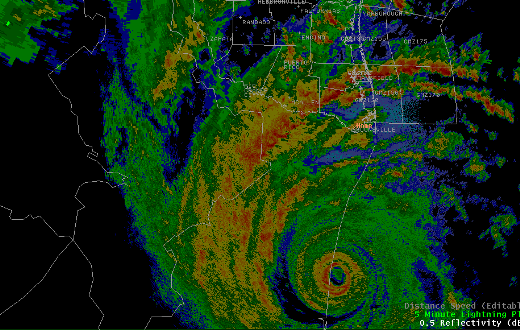
The cyclone, fighting areas of dry air and some wind shear, struggled to intensify on the 29th, but finally developed a classic banded circulation by afternoon and winds reached hurricane force by evening. Despite a steady pressure fall overnight, the cyclone remained a Category 1 wind storm with a small inner core. However, tropical storm force winds expanded and covered a good portion of the larger envelope by daybreak on the 30th. Alex, which had nudged on a due west track on the 29th, returned to a northwest track early on the 30th while continuing to intensify. At noon, the cyclone was around 130 miles southeast of Brownsville. Alex began wrapping up during the afternoon, eventually showing a clear eye late in the day. During the same period, high pressure building to the north of the storm helped turn the cyclone on a due west track while accelerating, and that track would bring the storm onshore near Punta de Piedras, Mexico just before 8 PM CDT, with a rapidly deepening center and excellent, though small, radar presentation around the center (above). The winds at landfall were 105 mph.
Impacts
Heavy rains began pelting the Lower and Middle Rio Grande Valley as isolated bands during the afternoon of the 29th, and returned after midnight on the 30th. More frequent bands arrived by mid morning, with the heaviest bands reaching into Willacy through eastern Hidalgo County, and another from just east of South Padre Island through southwest Cameron County, by early afternoon. These bands produced frequent wind gusts above 40 mph, rainfall of 2 to 5 inches, and embedded circulations which dropped at least three tornadoes in Cameron and Willacy County. As Alex approached the Tamaulipas coast, the strongest sustained winds arrived, generally at or just above tropical storm strength (39 mph) near the immediate coast. Gusts above 50 mph were common in eastern Cameron, Willacy, and Kenedy County, and 35 to 45 mph in Hidalgo and Brooks County. Additional late afternoon and evening rains brought more widespread moderate urban flooding, most common in poor drainage areas. Farther west, from Starr through Zapata and Jim Hogg County, the rainfall was a boon to maintaining drought and wild fire free conditions as the 4th of July weekend approached.
For the coast, significant storm surge was avoided with the inner core landfall well south of the area. Still, the enlarged envelope of tropical storm force winds brought seas up over 20 feet, and the east to northeast swell pushed tides above 4 feet on the east facing shorelines of South Padre Island and Port Isabel. Storm surge values exceeded 3 1/2 feet, and fortunately predicted astronomical tides were low, sparing most residences. The beach had moderate erosion and wave setup riding into the dunes, more than Gustav but less than Ike in 2008.
Click here for the latest text summary.
|

