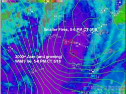
3.9 micron satellite image, at around 430 PM CT March 18th, showing explosive wild fire growth at the corner of Hidalgo, Brooks, Jim Hogg, and Starr County. Note the pixellated area in the larger circle. |

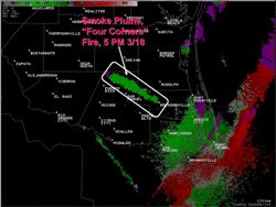
Doppler radar 0.5 elevation velocity image, around 4 PM CT March 18th, showing reflectivity plume (in light green) spreading southeast from the "Burns Ranch" wild fire. |
As advertised, a vigorous upper level cyclone moving northeast from northern Mexico through the heart of Texas during the Monday and Tuesday of Semana Santa induced an equally strong surface cyclone over the middle Rio Grande Valley of southwest Texas and extreme northern Mexico. This cyclone moved slowly east through the Lower Rio Grande Valley, producing persistent strong gusty winds, often averaging around 30 mph sustained with frequent gusts between 40 and 50 mph; building surf and swell to very high levels on South Padre Island, causing severe rip currents and minor coastal flooding, and leaving dangerous potential for explosive wild fire growth, which was realized on the 18th when very dry air flowed southeast on 50 mph wind gusts across parched land generally west of a McAllen to Falfurrias line.
Wind
Persistent southerly winds across the populated lower Rio Grande Valley eventually resulted in several reports of structural damage across the populated lower Rio Grande Valley, both on the 17th and 18th. News reports estimated more than 2000 customers without power for a time on the 17th, along with scattered minor damage to signs, tree limbs, power lines, and the like. Slightly stronger south winds across Brownsville and Harlingen on the morning of the 18th likely caused additional minor damage in these areas. However, the more notable damage on the 18th was reserved for mid afternoon in Hidalgo County and possibly other locations farther west, as a surge of sustained winds near 40 mph with gusts of at least 52 mph produced additional structural damage at industrial buildings, more downed power lines, and some tree damage. Two minor injuries were reported near McAllen from a partial roof or wall collapse at an old building. As of this writing, an estimated 7000 customers had lost power in portions of the area due to the winds. Peak wind Speeds for both March 17th and 18th are shown in tables, below:
|
Table 1: Peak Wind Speeds for Selected Locations, March 17th
|
Location
|
Peak Wind
|
Time (LT)
|
|
Harlingen/Valley Arpt
|
54 mph
|
1227 PM
|
|
Brownsville/Intl Arpt
|
48 mph
|
1044 AM
|
|
McAllen/Miller Arpt
|
48 mph
|
149 PM
|
|
Weslaco/Arpt
|
48 mph
|
200 PM
|
|
Port Isabel/Bayview Arpt
|
47 mph
|
120 PM
|
|
Edinburg
|
44 mph
|
305 PM
|
|
Falfurrias/Brooks Co. arpt
|
43 mph
|
245 PM
|
|
Hebbronville/Jim Hogg arpt
|
32 mph
|
1105 AM
|
|
Table 2: Peak Wind Speeds for Selected Locations, March 18th
|
Location
|
Peak Wind
|
Time (LT)
|
|
Harlingen/Valley Arpt
|
52 mph
|
1044 AM
|
|
Brownsville/Intl Arpt
|
52 mph
|
929 AM
|
|
Edinburg
|
52 mph*
|
410 PM
|
|
McAllen/Miller Arpt
|
51 mph*
|
309 PM
|
|
Laredo
|
48 mph*
|
156 PM
|
|
Hebbronville
|
47 mph*
|
605 PM
|
|
Falfurrias/Brooks Co. arpt
|
45 mph*
|
405 PM
|
|
Kingsville NAS
|
45 mph*
|
456 PM
|
*Northwest wind behind the front
|
|
Wild Fire
While there were several fire starts over the weekend and into the 17th, the explosive growth occurred during the afternoon of the 18th, when northwest winds of 25 to 35 mph with gusts locally near or above 50 mph combined with plummeting humidity values into the teens and 20s to help rapidly spread at least one fire, and perhaps up to three more. A brush and scrub fire near the intersection of Jim Hogg, Brooks, Hidalgo, and Starr Counties rapidly become a 2000 acre conflagration within only a couple of hours; other fires were noted near Hebbronville, Falfurrias, and in southeastern Starr County. The brush, scrub, and grass fire, eventually known as the Burns Ranch Fire, eventually scarred at least 26,500 acres of land, particularly in northern Hidalgo County, where the blaze was able to jump across federal highway 281. Another 3000 acre fire rapidly developed on the 19th near Encino (Brooks County), aided by gusty northwest winds as high pressure gradually built southeast into the lower Rio Grande Valley. The fire near Hebbronville, known as the Dana Fire, required fast action to protect residence of Hebbronville during the evening of the 18th.
While total structural damage from all of the fires is still being assessed, the latest information indicates that at least one property valued at $1 million was destroyed in the Burns Ranch Fire, and nearly 100 cattle were killed, with many more injured.
Seas and Surf
The strength and persistence of the cyclone extended well into the western Gulf, including a prolonged fetch of 20 knot or higher wind from deep in the Bay of Campeche. By mid afternoon on the 18th, sea heights had built to near 16 feet at the NOAA Buoy east of Padre Island (Kenedy County), and given a wave period of 10 to 11 seconds, both tidal overwash and rough, confused, and high surf was observed along South Padre Island, where thousands of people were enjoying Spring Break. Unfortunately, a number of vehicles were briefly stranded along the beach near and during high tide each afternoon. For mariners, winds generally remained between 17 and 27 knots, except at the coast where gale force gusts were observed, especially on Monday. Stronger winds were expected to surge across the waters overnight into March 19th.
Additional information may be posted on these events as it is received by the NWS office in Brownsville.
|

