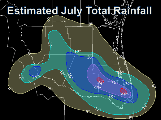
 July 2008: Early Soaking, Dolly Kill Drought Immense amounts of rain bookended the month of July, with torrential bursts from Hurricane Dolly not only ending the drought, but shattering some all time monthly records by several inches across much of the Lower Rio Grande Valley. The highest totals were found in extreme eastern Hidalgo, southwestern Willacy, and northern and central Cameron County. Unfortunately, a number of surface reporting stations, including airports, cooperative observers, and Community Collaborative Rain, Hail, and Snow (CoCoRaHS) network observers either did not report, or were unable to report, rainfall due to power outages in the path of Dolly's strongest winds across northern Cameron into southern Willacy County. A prolonged period of clouds and rain during the first full week of the month, followed by Dolly, and later, resulting slow evaporation of surface moisture which followed the storm, held monthly temperatures substantially below average for the middle of summer. Across the Lower Rio Grande Valley, temperatures were generally 1 to 2 degrees below the 30 year average, placing Brownsville, Harlingen, and McAllen within the top 20 coolest July's since records began (1878 in Brownsville, 1911 in Harlingen, and 1941 in McAllen). Harlingen (8th coolest) and McAllen (15th coolest) data are incomplete due to power loss after Dolly. Here are a couple of more interesting facts from Dolly's rains (6.68 inches) in Brownsville on July 23rd:
Below is a table of rain totals for July. Many locations, both official and unofficial, reported no data, insufficient data, or incomplete data. Locations such as Port Isabel/Cameron County Airport were knocked off line just as the heaviest rains were arriving during Dolly; available data was deemed too unrepresentative to include in this report. The table will be updated if and when additional representative rainfall information trickle in.
*Data Estimated.
i = Data Incomplete. . |
|||||||||||||||||||||||||||||||||||||||||||||||||||||||||||||||||||||||||||||||||||||||||||||||||||||||||||||